
Lautenbach (Ortenaukreis)
| coat of arms | Germany map | |
|---|---|---|

|
Coordinates: 48 ° 31 ' N , 8 ° 7' E |
|
| Basic data | ||
| State : | Baden-Württemberg | |
| Administrative region : | Freiburg | |
| County : | Ortenau district | |
| Height : | 215 m above sea level NHN | |
| Area : | 21.55 km 2 | |
| Residents: | 1875 (Dec. 31, 2018) | |
| Population density : | 87 inhabitants per km 2 | |
| Postal code : | 77794 | |
| Area code : | 07802 | |
| License plate : | OG, BH , KEL, LR, WOL | |
| Community key : | 08 3 17 067 | |
| Address of the municipal administration: |
Hauptstrasse 48 77794 Lautenbach (Ortenaukreis) |
|
| Website : | ||
| Mayor : | Thomas Krechtler ( CDU ) | |
| Location of the community Lautenbach (Ortenaukreis) in the Ortenaukreis | ||
  |
||

Lautenbach is a municipality in the Ortenaukreis in Baden-Württemberg .
geography
location
Lautenbach is located at the entrance to the Renchtal in the northern Black Forest . More than two thirds of the community area consists of forests.
Neighboring communities
The community borders in the north on Kappelrodeck , in the east on Ottenhöfen , in the south on the city of Oppenau and in the west on the city of Oberkirch .
Community structure
The Lautenbach community includes the villages Lautenbach and (Hinter and Vorder) Winterbach with Lierbach, the hamlets Hohenrain, Hubacker, Sendelbach, Unter-Rüstenbach, the mining settlement, the Zinken Ober-Rüstenbach, the courtyards Allerheiligensteig, Altschmatt, Braunberg, Hoferers Dobel, Oberhof, Otschenfeld, (Unterer) Sohlberg, Spitzenberg, Steighof, Sulzbach and Waldmühle and the residential areas of the electricity works and the forester's house in the Herrschaftswald. In the municipality are the abandoned villages Zur Birken, Hochberg, Sauhof and Trudkindesberge.
history
Until the 18th century
In 1233 the Lautenbach estate was mentioned in a document from the Allerheiligen monastery , other properties in the lower Renchtal were mentioned as early as the 10th century. However, no closed settlement developed, but Lautenbach remained a collection of hamlets and farmsteads in scattered locations for centuries. From 1316 to 1803 the place belonged to the diocese of Strasbourg , which is why it is still Roman Catholic today.
19th and 20th centuries
In 1803 Lautenbach came to the Grand Duchy of Baden along with the other possessions of the bishopric of Strasbourg on the right bank of the Rhine .
In 1815 Lautenbach became an independent municipality, which had long belonged to the Offenburg district and which merged with the new Ortenau district in 1973. During the municipal reform of the 1970s, the municipality was able to maintain its independence.
21st century
In 2007 there was a referendum to give up self-employment and to join the Lautenbach community with Oberkirch. The referendum, however, resulted in a narrow majority (52%) in favor of maintaining independence.
Population development
Population figures according to the respective area
|
politics
Administrative community
The community belongs to the agreed administrative community of the city of Oberkirch.
Municipal council
The election to the municipal council on May 25, 2014 led to the following result with a turnout of 61.7% (- 2.9):
| list | Share of votes | + / - | Seats | + / - |
| CDU | 44.8% | - 0.9 | 4th | - 1 |
| Citizen List | 26.9% | + 0.9 * | 3 | + 1 |
| BI "Future Lautenbach" | 28.4% | 3 | ± 0 |
* In the state statistics, the voter associations are only listed in summary.
mayor
- 1945–1976: Josef Müller (provisional, deployed by the French occupation forces)
- 1976–2000: Richard Bißdorf ( CDU / Free Voters)
- 2000–2015: Karl Bühler (CDU)
- 2015 to date: Thomas Krechtler (CDU)

Pilgrimage Church of
Maria Coronation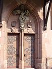
Entrance to the pilgrimage church


Culture and sights
Lautenbach's landmark is the late Gothic pilgrimage church of the Coronation of the Virgin , built between 1471 and 1488 . As a master builder, Hans Hertwig created sophisticated architecture in which the net vaults are particularly noteworthy. The late Gothic glass paintings come from the workshop of Peter Hemmel von Andlau . The panel paintings of the Gothic winged altar were created by an unknown artist who is often referred to as the master of the Lautenbach high altar .
A special sign of the deep-rooted belief is the large number of the Virgin Mary shrines that can be found throughout the Lautenbacher district.
Economy and Infrastructure
Lautenbach changed after the Second World War from a purely rural community to a residential community with several hundred commuters in the industrial and commercial areas of the area. There was also tourism in the Renchtal, of which the municipality can book a good share of 20,000 overnight stays per year.
Viticulture
The Agriculture Lautenbach is by vineyards and fruit growing coined. The documents belonging to the wine region Ortenau in the wine region Baden . In 2001/02 Lautenbach presented the Baden wine queen for the first time with Andrea Vogt. The municipal coat of arms indicates viticulture.
traffic
The community is connected with the Renchtalbahn ( Offenburg - Bad Griesbach ) with many places in Ortenau and is part of the Ortenau tariff association . The local rail guides the SWEG southwestern German state traffic company through which its trains as Ortenau-S-Bahn marketed. In addition, the community is on the federal highway 28 .
education
In Lautenbach there is a primary school with the Abt-Wilhelm-Schule . There is also a Roman Catholic kindergarten and the Sonnenkinder natural garden . All secondary schools are in the surrounding cities.
Individual evidence
- ↑ State Statistical Office Baden-Württemberg - Population by nationality and gender on December 31, 2018 (CSV file) ( help on this ).
- ^ The state of Baden-Württemberg. Official description by district and municipality. Volume VI: Freiburg region Kohlhammer, Stuttgart 1982, ISBN 3-17-007174-2 . Pp. 377-379
- ↑ State Statistical Office of Baden-Württemberg ( Memento of the original from February 4, 2015 in the Internet Archive ) Info: The archive link was inserted automatically and has not yet been checked. Please check the original and archive link according to the instructions and then remove this notice. and Lautenbach municipality
Web links

Achern | Appenweier | Bad Peterstal-Griesbach | Berghaupten | Biberach | Durbach | Ettenheim | Fischerbach | Friesenheim | Gengenbach | Gutach (Black Forest Railway) | Haslach im Kinzigtal | Hausach | Hofstetten | Hohberg | Hornberg | Kappel-Grafenhausen | Kappelrodeck | Throat | Kippenheim | Lahr / Black Forest | Run | Lautenbach | Mahlberg | Meißenheim | Mühlenbach | Neuried | Nordrach | Oberharmersbach | Oberkirch | Oberwolfach | Offenburg | Ohlsbach | Oppenau | Ortenberg | Ottenhöfen in the Black Forest | Renchen | Rheinau | Ringsheim | Rust | Sasbach | Sasbachwalden | Schuttertal | Schutterwald | Schwanau | Seebach | Seelbach | Steinach | Willstätt | Wolfach | Zell am Harmersbach
Rheinau (municipality-free area)