
Rench
| Rench | ||
 Course of the Rench ( interactive map ) |
||
| Data | ||
| Water code | EN : 2354 | |
| location |
Black Forest
|
|
| River system | Rhine | |
| Drain over | Rhine → North Sea | |
| source | at Kniebis near Bad Griesbach in the Black Forest - refuge Q. Schöngrundbächle 48 ° 29 ′ 27 ″ N , 8 ° 14 ′ 49 ″ E |
|
| Source height | approx. 915 m above sea level NHN | |
| muzzle | at Rhine km 314.8, at Rheinau / Lichtenau / Helmlingen in the Rhine Coordinates: 48 ° 43 '22 " N , 7 ° 58' 0" E 48 ° 43 '22 " N , 7 ° 58' 0" E |
|
| Mouth height | 123 m above sea level NHN | |
| Height difference | approx. 792 m | |
| Bottom slope | approx. 14 ‰ | |
| length | 57 km | |
| Catchment area | 306.1 km² | |
| Discharge at the Ramsbach A Eo gauge : 108 km² Location: 38.1 km above the mouth |
NNQ (09/04/1949) MNQ 1929/2009 MQ 1929/2009 Mq 1929/2009 MHQ 1929/2009 HHQ (06/27/1994) |
97 l / s 630 l / s 3.69 m³ / s 34.2 l / (s km²) 65.7 m³ / s 190 m³ / s |
| Drain |
MQ |
8.37 m³ / s |
| Left tributaries | Ödsbach, Hesselbach | |
| Right tributaries | Lierbach , Acher (subset) | |
| Small towns | Oppenau , Oberkirch , Renchen | |
| Communities | Bad Peterstal-Griesbach , Lautenbach , Erlach | |
| Residents in the catchment area | 88650 | |
 Rench dam near Lautenbach |
||
|
Tributaries and hydraulic structures
|
|||||||||||||||||||||||||||||||||||||||||||||||||||||||||||||||||||||||||||||||||||||||||||||||||||||||||||||||||||||||||||||||||||||||||||||||||||||||||||||||||||||||||||||||||||||||||||||||||||||||||||||||||||||||||||||||||||||||||||||||||||||||||||||||||||||||||||||||||||||||||||||||||||||||||||||||||||||||||||||||||||||||||||||||||||||||||||||||
The Rench is a right tributary of the Rhine in the Ortenau ( Middle Baden ) coming from the Black Forest .
Surname
The Rench was mentioned in 1291 as rivus Reineche . Albrecht Greule sees an Indo-European root * reg- with the basic meaning “to be moist”.
course
The Rench rises on the southern edge of the northern Black Forest at Kniebis near Bad Griesbach in the Black Forest . The Schöngrundbächle rises at around 915 m above sea level at the source furthest from the mouth of the Refuge district of the Black Forest community near the former youth hostel . NN , which, after passing through its steep slope , flows together with other streams first to the Alten , then to the Wild Rench , which is only called Rench below Bad Griesbach . The Rench runs altogether in a distinctive south curve through the Middle Black Forest and, crossing the hilly Ortenau fruit and wine-growing region, emerges into the Rhine plain. After almost 57 km it flows at Rhine km 314.8 between Helmlingen ( Rheinau ) and Lichtenau without separating strip of land next to the Mühlbach in the Rhine .
The Rench flood canal was built between 1936 and 1953 for the Acher-Rench correction to divert floods . It branches off from the Rench at Erlach , takes up the Acherkanal at Rheinau and reunites with the actual Rench at Memprechtshofen .
Valley landscape
The upper Renchtal around Bad Peterstal-Griesbach is initially cut into wooded red sandstone plateaus and turns into a more open, very restless and steeply relief valley landscape, the center of which is the small town of Oppenau . There the Lierbach, known for its waterfalls, flows from the right . In Lautenbach , the valley suddenly widens into the foothills zone with the town of Oberkirch at the foot of vineyards and the small town of Renchen , whose surroundings are characterized by fruit growing.
The B 28 leads through the Renchtal , an important Black Forest crossroad that connects the Strasbourg area with the upper Neckar area. Above Bad Griesbach it leads steeply and serpentine up to the Alexanderschanze (968 m). The Renchtalbahn runs from Appenweier to Bad Griesbach . It also contributed to the development of the spa in the Renchtal, which began in Bad Griesbach in the 16th century and which soon expanded to Bad Antogast near Oppenau (especially high nobility), Bad Peterstal and Bad Freiersbach (now Bad Peterstal-Griesbach).
gallery

Rench in Oppenau
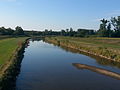
Rench near Helmlingen when the water level is low

Rench in the alluvial forest near Helmlingen

The Rench flows into the Rhine


Individual evidence
- ↑ a b According to the contour image or the digital terrain model on the geodata viewer.
- ↑ Length of the Rench according to LUBW-FG10 (data record entry).
- ↑ Total catchment area of the Rench according to LUBW-BRSWEB, catchment areas, aggregated areas 04 (data record entry).
- ^ German Hydrological Yearbook Rhine Region, Part I 2009 State Institute for Environment, Measurements and Nature Conservation Baden-Württemberg, p. 88, accessed on January 22, 2016 (PDF, German, 1.85 MB).
- ↑ Freiburg Regional Council: TBG accompanying documentation Acher-Rench (33), Tab. A 7.2.1, Freiburg i. Br. 2009 (converted from m³ / a).
- ↑ Freiburg regional council: TBG accompanying documentation Acher-Rench (33), Freiburg i. Br. 2009.
- ^ Albrecht Greule: The origin and meaning of the place name Regensburg. Online publication of the University of Regensburg from March 1st, 2008. It also makes comparative references to the Latin rigare (“to water ”) and the Icelandic rakr (“moist”).
Web links
- "LUBW-BRSWEB": State Institute for the Environment Baden-Württemberg (LUBW) ( information )
-
Geoportal Baden-Württemberg ( information ), especially with the partial maps / layers
- the State Institute for the Environment, Measurements and Nature Conservation Baden-Württemberg (LUBW)
- "LUBW-FG10": River 1: 10,000
- "LUBW-SG10": Standing water 1: 10,000
- "LUBW-GEZG": water catchment areas
- the State Institute for the Environment, Measurements and Nature Conservation Baden-Württemberg (LUBW)
- Map of the Rench from source to mouth on OpenStreetMap on OpenStreetMap