Acher-Rench correction
The Acher-Rench correction (abbreviated Areko ) was a hydraulic engineering measure carried out in Mittelbaden between 1936 and 1967 . With the measure in the Upper Rhine plain between the cities of Offenburg and Baden-Baden , the flood protection in the catchment area of the rivers Acher and Rench on the right bank of the Rhine should be improved and the agriculturally usable areas expanded.
Natural space and waters
Acher and Rench arise on the western slope of the northern Black Forest , the mountains of which are over 1000 m above sea level. Reach NN . Annual precipitation of 800 to 2000 millimeters per year and the steep drop in the river valleys of the Black Forest to the Upper Rhine Plain lead to very rapid flood runoff , which can occur both in summer and in winter.
Along the Black Forest, at the edge of the Rhine Plain, there is a damp depression known as the Kinzig-Murg Rinne , in which the rivers from the Black Forest used to turn north and only after a long run in the Rhine Plain flowed into the Rhine . After the rivers had formed alluvial cones at the point of entry into the Rhine Plain , they were able to shorten their course and flow to the Rhine on a more direct route.
To the south of Bühl, in the part of the Rhine plain through which the Acher and Rench flows, depressions dominate, so that up to 80% of the area used to be flooded. Linear gravel ridges, so-called Hurste, which were preferred to found settlements, were flood-proof. Place names such as Wagshurst or Gamshurst refer to this .
prehistory
There was river construction on the Rench before the 19th century; The aim of the non-coordinated measures was to protect individual settlements. Since 1816, river construction was regulated by the Baden River Construction Edict, with which the protection of flood-prone river sections was combined in the State River Construction Association and subjected to uniform planning. The state of Baden assumed two thirds of the costs; the rest had to be borne by the communities. In 1810, under the direction of Johann Gottfried Tulla , the regulation of the Rench began. As with other Black Forest rivers, the river, which was previously up to 400 meters wide near Oberkirch , was straightened and laid in a bed with a double trapezoidal profile. In 1885 the correction of the upper Rench run to Erlach was finished.
There were various drafts for the lower reaches of the Rench, the realization of which failed due to the disagreement of the communities involved. A plan by Robert Gerwig from 1855 provided for a flood canal that was to run to the left of the Rench from Erlach to Memprechtshofen . In 1909 a memorandum of the Grand Ducal Direction of Water and Road Construction was written on the correction of the reindeer and the improvement of the May forest . This was an area traversed by the Rench between Wagshurst in the south and Memprechtshofen in the north, which until 1811 had been used jointly by several communities as the Markwald . In 1811, the Maiwald was divided between the communities and largely cleared in the following years. The resulting meadows were swampy due to frequent flooding by the Rench and hardly usable for agriculture. The memorandum of 1909 provided for the elimination of the floods by building the flood canal; Moreover, the Maiwaldgebiet with irrigation and drainage ditches should be subjected to a systematic Wiesenwässerung allow.
Between 1927 and 1929 the plans to improve the May forest were implemented in a simplified form. The Rench was straightened in the Maiwald ; In addition, a canal was built to drain the Rench floods. Further work was not done due to the global economic crisis .
activities
After the transfer of power to the National Socialists , the Reich Labor Service (RAD) began planning flood protection measures for the Acher and Rench in 1933. In view of the prolonged unemployment in Baden, these were also viewed as job creation measures. At gatherings to propagate the production battle in 1934, farmers are said to have pointed out that “it would have little value to fertilize properly, because a flood would destroy all work.” According to the permit application for the Acher-Rench correction, the “given favorable climatic and geographical conditions ”in the correction area“ not properly exploited. The rivers coming from the Black Forest and flowing into the Rhine are to blame for this condition ”. The planning was based on the assumption that 150 new hereditary farms or 600 additional smallholder positions could be created in the correction area. The total effort was estimated at around 500,000 daily work .
In March 1936 a “law to improve the water management conditions in the Rhine valley between the Kinzig and the Sandbach (Acher-Rench correction)” was passed. The law named 66 municipalities that had to finance a third of the costs. Procedures under water law in connection with the development of water bodies were omitted; also have been land acquisition and expropriation easier. The main aim of the Acher-Rench correction was to ensure flood protection. In addition, swampy and wet areas should be drained. Uses in the existing waters such as mills and meadow irrigation should continue to be possible. The corrective measures affected an area of 120 square kilometers, three quarters of which were used for agriculture and a quarter for forestry.
The first cut of the spade for the Acher-Rench correction took place on July 2, 1936 in Memprechtshofen by the NSDAP Gauleiter Robert Wagner . Several thousand employees of the Reich Labor Service were used for the construction work. They were largely withdrawn in May 1938 and transferred to the Siegfried Line; With the beginning of the Second World War , the work was stopped. Between 1940 and 1942, up to 500 French prisoners of war from a camp in Renchen worked on building the Acher-Rench correction. The continuation of the work during the war was justified, among other things, by the fact that the correction work was necessary for the construction of the Reichsautobahn from Baden-Baden to Strasbourg . After the end of the war, construction work was resumed in 1949. From 1954, land consolidation procedures for the construction of the motorway from Karlsruhe to Basel (today's federal motorway 5 ) determined the construction process.
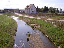
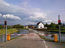
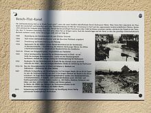
The construction work initially concentrated on the construction of the flood channels for Acher and Rench; In 1940 the lower part of the Rench flood canal and the Acher flood canal were completed. The upper part of the Rench Flood Canal went into operation in 1954 after the construction of a branch structure near Erlach. On the Rench, the three flood retention basins Holchen, Hürben and Mürbig were created in forest areas, which can hold five million cubic meters of water over four square kilometers. The Sandbach flood channel and a retention basin for two million cubic meters of water in the Abtsmoor were built on the Bühlot , which enters the Rhine valley near the city of Bühl and bears the name Sandbach in the lower reaches. A common flood channel was built for Sasbach , Laufbach and Röderbach, which ends west of Ottersweier in the Hägenich retention basin . The Durbach-Kammbach-Wannenbach Canal (DKW Canal) feeds the water from the three eponymous brooks that leave the Black Forest between Appenweier and Offenburg to the Rench flood canal. In addition, numerous other drainage ditches and receiving waters were built, such as the Rhine Low Canal , which was completed in 1960 , in which the bottom and the lower part of the embankment were often secured with stone paving to prevent bottom erosion. After the drainage, 22 emigrant farms were built in the May Forest .
After its completion, the Acher-Rench correction was described in 1969 as “one of the largest water management and regional cultural companies in the state of Baden-Württemberg”, “which has significantly changed the face and value of the Central Baden landscape”. 8.22 million RM (1938–1948) and 47.5 million DM (1948–1968) were invested. 216 kilometers of water bodies were expanded or newly built and 85 kilometers of river dikes were built. Five railway bridges and 141 road bridges as well as around 300 weirs , falls, locks and culverts were built . With regard to the set goals, the Acher-Rench correction is considered a success and “outstanding engineering achievement”. During floods in 1978, 1983 and 1994, most of the facilities built proved themselves. The implementation of the Acher-Rench correction enabled more intensive agricultural use of the area; in addition, the settlement areas could expand considerably. From the 1970s onwards, the ecological disadvantages of river development became clear and led to a change in which water bodies were renatured and their own dynamic development encouraged.
Further development
Investigations to improve flood protection in the 1990s showed that the dykes at the Rench and Acher flood channels and at the retention basins had to be rehabilitated. At the same time, a higher drainage capacity in sections of the Rench flood canal was considered necessary in order to achieve protection against a hundred-year flood . Between 1998 and November 2011, 38 kilometers of dams and dykes were rehabilitated; In addition, the control system of a regulating weir was renewed. In 2011, around 40 kilometers of dyke were still in need of renovation.
Inventories of the European Water Framework Directive classified almost all bodies of water in the area of the Acher-Rench Correction as "significantly morphologically impaired". Long stretches of the Rench flood canal are said to have high ecological potential. One of the largest populations of the river mussel in Baden-Württemberg has settled in the artificial body of water ; The fish species bitterling and brook lamprey were also found. The canal has been designated as a Natura 2000 area. In order to maintain the efficiency of the canal, water maintenance is necessary, in which the foreland is removed, the mean water bed cleared and mowed . In order to give animals the opportunity to retreat, water maintenance is carried out on one side and only when necessary.
Between 1987 and 2002, 30 kilometers of water in the area of the Acher-Rench Correction were remodeled in a natural way. Further measures are aimed at restoring the continuity of waters for migratory fish . With the help of an extensification program for agriculture, an attempt was made to convert strips of watercourse into extensively used grassland .
literature
- Sandra Röck: Nature quality and assessment of artificial waters using the example of two flood channels in the Upper Rhine Plain. (= Culterra , Volume 53) Institute for Land Care, Freiburg im Breisgau 2008, ISBN 978-3-933390-40-0 .
- Sandra Röck: The Rench flood canal. The nature of an artificial body of water. In: Christoph Ohlig (Ed.): Water development in the cultural landscape. (= Writings of the German Water History Society , Volume 7) Books on Demand, Norderstedt 2005, ISBN 3-8334-3213-6 , pp. 239–249 ( online ; PDF; 12.6 MB).
- Horst Brombacher: The Acher-Rench correction and the use of French prisoners of war. In: Die Ortenau , 2003 (83), ISSN 0342-1503 , pp. 87-106 ( online ).
Web links
- Rench river development and Acher-Rench correction. Regional council Freiburg (PDF, 392 kB).
Individual evidence
-
↑ Bernhard Burkart, Bernhard Walser: The Acher-Rench correction. (PDF) (No longer available online.) In: rp.baden-wuerttemberg.de. Regional Council Baden-Württemberg, p. 1 f. , formerly in the original ; Retrieved April 18, 2012 . ( Page no longer available , search in web archives ) Sandra Röck: Nature quality. P. 61.
- ^ Josef Riegelsberger: Acher-Rench correction. In: Ministry of the Interior of Baden-Württemberg (Ed.): Water management in Baden-Württemberg. Water supply, sewage disposal, river engineering, dam construction, agricultural hydraulic engineering, administration, organization. Verwaltungs-Verlag, Munich 1969, pp. 146–152, here p. 146.
-
^ Bernhard Burkart, Bernhard Walser: Acher-Rench correction. P. 3 f.
Sandra Röck: Nature quality. P. 63. - ^ Adolf Drach: Draft of the Rench correction downwards Erlach and the Maiwaldkultur. Memorandum 1909. (= Contributions to the hydrography of the Grand Duchy of Baden , Volume 15) Braun, Karlsruhe 1913.
- ^ Adolf Drach: Draft of the Rench correction. Pp. 24-52.
-
^ Bernhard Burkart, Bernhard Walser: Acher-Rench correction. S. 5.
Sandra Röck: Quality of nature. P. 64. - ↑ Quoted from Horst Brombacher: Prisoners of War. P. 92.
- ↑ Quoted from Horst Brombacher: Prisoners of War. P. 90.
- ↑ Horst Brombacher: Prisoners of War. P. 93 f.
- ↑ Law to improve the water management conditions in the Rhine plain between the Kinzig and the Sandbach (Acher-Rench correction). Retrieved April 20, 2012.
- ^ Bernhard Burkart, Bernhard Walser: Acher-Rench correction. P. 6.
- ↑ a b Sandra Röck: Nature quality. P. 67.
- ^ Riegelsberger: Acher-Rench correction. P. 147.
- ↑ Horst Brombacher: Prisoners of War. P. 97 ff.
-
^ Bernhard Burkart, Bernhard Walser: Acher-Rench correction. Pp. 6-10.
Sandra Röck: Nature quality. P. 67. - ↑ a b Peter Homagk: Flood protection on the Upper Rhine to Worms in the course of the last 200 years. In: Wasserwirtschaft 1–2 / 2010, pp. 35–41, here p. 37.
-
^ Riegelsberger: Acher-Rench correction. S. 150.
W. Schweinfurth, H. Klüver: Bühl. Natural space and settlement. In: Landesarchivdirektion Baden-Württemberg (ed.): The district of Rastatt. Thorbecke, Stuttgart 2002, ISBN 3-7995-1364-7 . Pp. 381-400, here p. 389. - ↑ a b Riegelsberger: Acher-Rench correction. P. 150.
- ^ Bernhard Burkart, Bernhard Walser: Acher-Rench correction. P. 9 f.
- ^ Riegelsberger: Acher-Rench correction. Pp. 146, 152.
-
^ Riegelsberger: Acher-Rench correction. S. 147.
According to Horst Brombacher: Prisoners of War. Pp. 105, 211 road bridges. - ^ Bernhard Burkart, Bernhard Walser: Acher-Rench correction. P. 11.
- ↑ Sandra Röck: Nature Quality. P. 68.
- ↑ Sandra Röck: Rench flood canal. P. 249.
- ^ Bernhard Burkart, Bernhard Walser: Acher-Rench correction. P. 12 f.
- ↑ Sandra Röck: Nature Quality. P. 87.
- ↑ This assessment by Sandra Röck: Rench-Flutkanal. P. 245.
- ↑ Sandra Röck: Rench flood canal. P. 247 f.
-
^ Bernhard Burkart, Bernhard Walser: Acher-Rench correction. S. 16.
Water Directorate South Upper Rhine / High Rhine (Ed.): Further development of the Acher-Rench correction in the Ortenau district. Flood protection and water ecology in harmony. (PDF) (No longer available online.) Offenburg 2003, p. 14 , formerly in the original ; Retrieved April 20, 2012 . ( Page no longer available , search in web archives )
Coordinates: 48 ° 40 ′ N , 8 ° 1 ′ E


