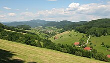
Middle Black Forest
The Middle Black Forest , depending on the natural or cultural structure ( see: Black Forest ), usually refers to the intensely divided section from the Renchtal and the southern foothills of the Kniebis in the north to Freiburg im Breisgau and Donaueschingen in the south. The highest part southeast of the Elz valley is also considered part of the Black Forest. The dominant valley system of the Kinzig cuts through the Middle Black Forest from east to west. Striking elevations are south of the Kinzig Kandel ( 1241.3 m ), Weißtannenhöhe ( 1190.5 m ), Obereck ( 1178.2 m ), Rohrhardsberg ( 1153.2 m ), Brend ( 1149.3 m ), Stöcklewald ( 1069, 2 m ), Mooswaldkopf ( 879.7 m ) and, north of the Kinzig, Brandenkopf ( 945.9 m ) and Lettstädter Höhe ( 966.7 m ).
Gneisses and granites predominate . In contrast to the northern Black Forest , the red sandstone ceiling with its plateau-like mountain shapes is only preserved at certain points and on the eastern edge. Otherwise there are narrow ridges and valley bottoms or, especially in the southeast or in island-like remains, hilly high valley landscapes.
The mean height of the Middle Black Forest is slightly lower than in the northern and southern Black Forest . The relative heights are similar, however; Steep slopes can exceed 700 meters ( Simonswälder Valley ).
Significant partial landscapes and natural monuments
- Kinzigtal
- Glottertal (known from the TV program Die Schwarzwaldklinik )
- Elz Valley
- Simonswälder Valley of the Wild Gutach
- Bernecktal, gorge of the upper Schiltach
- Kostgfall Gorge
- Triberg waterfalls
- Zweribach waterfalls
- Burgbach waterfall
- Glaswaldsee under the Lettstädter Höhe
Important places and cultural monuments
- Vogtsbauernhof open-air museum
- German clock museum in Furtwangen
- Half-timbered towns Schiltach and Haslach in the Kinzig valley
- Wolfach , glassworks and old town
- Gengenbach , formerly a free imperial city (old town with monastery and city fortifications)
- Alpirsbach , Romanesque monastery (construction started around 1050), one of the few preserved in the Hirsau style
- Zell am Harmersbach , formerly the smallest Free Imperial City in the Holy Roman Empire , half-timbered and Art Nouveau
- Schramberg , an important industrial city in the Middle Black Forest
- St. Peter's monastery with a baroque library and monastery church
- Villingen-Schwenningen , largest city on the eastern edge of the Middle Black Forest
- Triberg with its waterfall and the Black Forest local museum
- St. Georgen with the Phonomuseum
Hiking trails
- Hansjakobweg I (circular route 3 days)
- Hansjakobweg II (circular route 4 days)
- Black Forest Cross Path Rottweil – Lahr (4 days)
- Black Forest Cross Path Gengenbach – Alpirsbach (2–3 days)
- Mittelweg (long-distance hiking route)
- Ostweg (long-distance hiking route)
- Westweg (long-distance hiking route)
- Kandelhöhenweg (5 days)
- Zweälersteig (long-distance hiking route 5 days)

