
Hansjakobweg II
| Hansjakobweg II | |
|---|---|
 Information sign at Biberach train station |
|
| Data | |
| length | 92 km |
| location | Germany, Baden-Wuerttemberg , Black Forest |
| Supervised by | Black Forest Association |
| Markers | Black Hansjakobhut in a white diamond |
| Start / finish point |
Haslach 48 ° 16 '33.7 " N , 8 ° 5' 9.7" E |
| Type | Circular hiking trail |
| Height difference | 740 m |
| The highest point | Brandenkopf ( 946 m ) |
| Lowest point | Steinach ( 205 m ) |
| Level of difficulty | light |
| season | Spring to autumn |
| Viewpoints | Brandenkopffturm; Urenkopf tower |
The Hansjakobweg II (also: Großer Hansjakobweg) is a five-day circular hiking route through the central Black Forest from Haslach in the Kinzig valley back to Haslach. The approximately 93 km long hiking trail is named after the Baden folk writer and pastor Heinrich Hansjakob (1837–1916). The path was inaugurated in 1983 and is maintained and looked after by the Black Forest Association.
The path sign is a white diamond with a black Hansjakobhut, the headgear with which Heinrich Hansjakob is depicted in many contemporary pictures and photographs. In addition to the signposting with the signpost, there are explanatory boards at all sights, which mainly refer to the life and work of Hansjakob.
Day tours / stages
First stage: Haslach - Wolfach
Haslach - Sandhaasenhütte - Hausach - Gutach / Turm - Wolfach (16.5 km)
Second stage: Wolfach - Brandenkopf
Wolfach - Hohenlochen - Burzbühl - Bettelfrau - Brandenkopf (11 km)
Third stage: Brandenkopf - Zell am Harmersbach
Brandenkopf - Durben - Oberharmersbach - Mühlstein ( Nordrach ) - Zell am Harmersbach (21 km)
Fourth stage: Zell am Harmersbach - Höhenhäuser
Zell am Harmersbach - Niller Eck - Steinach - Heidenschlössle - Höhenhäuser (Gasthof Kreuz) (27 km)
Fifth stage: Höhenhäuser - Haslach
Höhenhäuser - Biereck - Hansjakobkapelle - Hofstetten - Haslach (17.5 km)

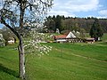
Upper farm in Sulzbachtal (1st stage)

Village church, Hausach-Dorf (1st stage)
At the Vogt on Mühlstein (3rd stage)

Mostbänkle (3rd stage)

Barberast, Welschbollenbach (4th stage)
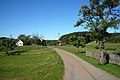
Höhenhäuser (4th / 5th stage)

Fehrenbacher Kreuz (5th stage)


literature
- Martin Kuhnle: Black Forest Middle / North. Bergverlag Rother, Munich 2013, ISBN 978-3-7633-4420-8 , pp. 166-187.
Web links
- Black Forest hiking service : Web application of the Black Forest Association to visualize the Black Forest hiking trails in Google Maps with various overlays (route network, signposts, accommodations, ...)
High trails: Westweg Pforzheim – Basel | Mittelweg Pforzheim – Waldshut | East route Pforzheim – Schaffhausen
Cross paths: Gengenbach – Alpirsbach | Rottweil – Lahr | Black Forest – Kaiserstuhl – Rhine | Freiburg – Lake Constance | Hotzenwald-Querweg | Hochrhein-Querweg
Randwege: Nordrandweg | Kandelhöhenweg | Gäurandweg | Black Forest-Jura-Bodensee-Weg
Others: Kleiner Hansjakobweg | Great Hansjakobweg | Ortenau Wine Trail | Breisgau Wine Trail | Markgräfler Wiiwegli | Renchtalsteig | Schluchtensteig | Zweälersteig