Renchtalsteig
| Renchtalsteig | |
|---|---|
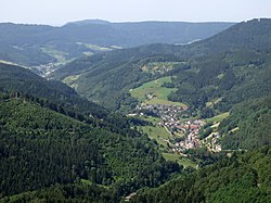
 View from the Bauernkopf into the Renchtal |
|
| Data | |
| length | 98 km |
| location | Germany, Baden-Wuerttemberg , Black Forest |
| Supervised by | Black Forest Association |
| Markers | Blue-green diamond with a stylized "rs" on a white background |
| Starting point |
Bottenau 48 ° 31 '12.4 " N , 8 ° 2' 58.8" E |
| Target point |
Schauenburg ruins 48 ° 32 ′ 19 " N , 8 ° 5 ′ 41.5" E |
| Type | trail |
| Height difference | 863 m |
| The highest point | Schliffkopf ( 1056 m ) |
| Lowest point | Bottenau ( 192 m ) |
| Level of difficulty | medium |
| season | Spring to autumn |
| particularities | Prädikatswanderweg |
The Renchtalsteig is a 98 km long hiking trail in the Black Forest Middle / North Nature Park . It leads in five stages around the Renchtal with start and finish near Oberkirch .
history
The Renchtalsteig was certified for the first time on January 15, 2011 by the German Hiking Association as a "Quality Walk in Germany" and opened on May 22, 2011.
Brief description
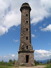
From the starting point in Bottenau , the Renchtalsteig runs through vineyards to Staufenberg Castle and on to Mooskopf with the Moosturm. With partly steep ascents and descents, the path leads on the south side of the Renchtal past Oppenau and Bad Peterstal to the Alexanderschanze . After the Rench spring, the highest point is reached at the Schliffkopf . The path leads down to the Allerheiligen monastery ruins and the waterfalls . Back in the Renchtal, the end point is reached at the ruins of the Schauenburg .
Day tours / stages
First stage: Bottenau - Oppenau
Overview
- Distance: 22.7 km
| Place / sight | Distance (km) |
Height (m above sea level ) |
Further information |
|---|---|---|---|
| Bottenau town hall | 0 | 192 | Bus connection |
| St. Wendelin | 0.8 | 255 | Pilgrimage chapel |
| Staufenberg Castle | 3.5 | 365 | Vineyard with wine bar |
| Brandstetter Chapel | 1.4 | 319 | |
| Furnace hole | 6.1 | 592 | Refuge |
| Moss head | 2.9 | 872 | Observation tower |
| Calicuttons | 4.2 | 503 | Höhenhotel |
| Hugenhöfe | 3.8 | 291 | 0.4 km to Oppenau station |
Directions
The starting point of the Renchtalsteig is the Bottenau town hall on the K 5369. From there it goes via St. Wendelin on scenic paths to Staufenberg Castle. The ascent to the Mooskopf begins at the Brandstetter Chapel and is reached along with the Kandelhöhenweg . From the Moosturm the path leads steadily downwards via Kalikutt to the Hugenhöfe near Oppenau.
Second stage: Oppenau - Bad Peterstal
Overview
- Distance: 16.4 km
| Place / sight | Distance (km) |
Height (m above sea level) |
Further information |
|---|---|---|---|
| Hugenhöfe | 0 | 291 | 0.4 km from Oppenau train station |
| Ibacher Holzplatz | 3.5 | 745 | Lookout point |
| Lochbergwasen | 3.7 | 650 | Hikers' parking lot with kiosk |
| Hermersberger Hut | 5.4 | 825 | Lookout point |
| Kurhaus Bad Peterstal | 3.8 | 400 | 0.4 km to Bad Peterstal train station |
Directions
From the Hugenhöfen the path leads over the Ibacher Holzplatz to the Lochbergwasen pass. The Hermersberger hut is reached together with the Gengenbach – Alpirsbach crossing. The descent to Bad Peterstal begins here.
Third stage: Bad Peterstal - Alexanderschanze
Overview
- Distance: 19.3 km
| Place / sight | Distance (km) |
Height (m above sea level) |
Further information |
|---|---|---|---|
| Kurhaus Bad Peterstal | 0 | 400 | 0.4 km from Bad Peterstal train station |
| Palm spring | 4.6 | 625 | |
| Lake level | 2.2 | 942 | Junction to the Glaswaldsee |
| Lettstädter Höhe | 1.6 | 964 | Refuge |
| Sexauer hut | 2.9 | 769 | Barbecue area with shelter |
| Devil's pulpit | 1.3 | 944 | |
| Hildahütte | 2.1 | 915 | Refuge |
| Alexanderschanze | 4.6 | 968 | Hikers' parking lot, bus connection |
Directions
The path leads from the Kurhaus Bad Peterstal over the Holchen waterfall to the former Waldhotel Palmspring. After the ascent to the lake level, the Renchtalsteig meets the Westweg for the first time . With a view of the Glaswaldsee , we continue to the Lettstädter Höhe. The path leads downwards past the Rappenschliff to the Sexauer Hütte. The Westweg is reached again, steeply uphill through the Teufelskanzel. After the Hildahütte, the scenic high path leads to the Alexanderschanze on the B 28 .
Fourth stage: Alexanderschanze - Allerheiligen waterfalls
Overview
- Distance: 23.2 km
| Place / sight | Distance (km) |
Height (m above sea level) |
Further information |
|---|---|---|---|
| Alexanderschanze | 0 | 968 | Hikers' parking lot, bus connection |
| Renchtalhütte | 5.8 | 752 | Serviced hut |
| refuge | 4th | 954 | Hikers' car park, hotel |
| Lothar path | 2.9 | 930 | Branch to the Lothar path |
| Steinmäuerle | 3.5 | 1,000 | Parking lot for hikers |
| Grinding head | 0.8 | 1,056 | |
| All Saints Day | 3.8 | 637 | Monastery ruins and courtyard |
| All Saints Waterfalls | 2.4 | 518 | Hikers' parking lot, bus connection |
Directions
From the Alexanderschanze the path leads past the Rench spring to the Renchtalhütte. This is followed by the ascent to the refuge, where the Westweg is reached again. With a view of the Lierbachtal and the Vosges , you continue to the Schliffkopf, the highest point of the Renchtalsteig. This is where the descent to the Allerheiligen monastery ruins begins . From there the path leads over lookout rocks above the waterfalls to the hiking car park.
Fifth stage: Allerheiligen waterfalls - Schauenburg castle ruins
Overview
- Distance: 16.4 km
| Place / sight | Distance (km) |
Height (m above sea level) |
Further information |
|---|---|---|---|
| All Saints Waterfalls | 0 | 518 | Hikers' parking lot, bus connection |
| All Saints Day | 1.3 | 637 | Monastery ruins and courtyard |
| Sohlberg | 4.5 | 665 | Parking lot for hikers |
| Simmerbacher Cross | 2.8 | 602 | |
| Rappenschrofen | 0.4 | 641 | Lookout point |
| Schwalbenstein | 4.9 | 410 | Hussar monument, lookout point |
| Schauenburg ruins | 1.9 | 375 | |
| Schauenburg car park | 0.6 | 320 | 1.8 km to Oberkirch train station |
Directions
From the hiking car park, the path leads along the waterfalls back to the Allerheiligen monastery ruins. Via St. Ursula and Sohlberg it goes to the Simmersbacher Kreuz. Following a piece of the rock path, the path leads to the Rappenschrofen and on to the Schwalbenstein with a view of the Rhine plain . The Renchtalsteig ends below the Schauenburg ruins at the parking lot.
literature
- Black Forest Middle / North Nature Park (Ed.): Hiking on the Renchtalsteig .
- Martin Kuhnle: Black Forest Middle / North. Bergverlag Rother, Munich 2013, ISBN 978-3-7633-4420-8 , pp. 122-139.
Web links
- Renchtalsteig - Website of Renchtal Tourismus GmbH
- Renchtalsteig - Website of the Schwarzwald Tourismus GmbH
- Waymarked Trails - overview map, elevation profile and GPX download of the Renchtalsteig based on OpenStreetMap data
- Hiking service Black Forest - hiking portal of the Black Forest Association with different map views and overlays (route network, signposts, accommodations, ...)
Individual evidence
- ↑ press release. (PDF; 82 KB) German Hiking Association, January 13, 2011, archived from the original on October 30, 2014 ; accessed on February 22, 2016 .


