
Oppenau
| coat of arms | Germany map | |
|---|---|---|

|
Coordinates: 48 ° 28 ' N , 8 ° 10' E |
|
| Basic data | ||
| State : | Baden-Württemberg | |
| Administrative region : | Freiburg | |
| County : | Ortenau district | |
| Height : | 277 m above sea level NHN | |
| Area : | 73.04 km 2 | |
| Residents: | 4718 (Dec 31, 2018) | |
| Population density : | 65 inhabitants per km 2 | |
| Postal code : | 77728 | |
| Area code : | 07804 | |
| License plate : | OG, BH , KEL, LR, WOL | |
| Community key : | 08 3 17 098 | |
| LOCODE : | DE OPU | |
| City structure: | Five districts | |
City administration address : |
Rathausplatz 1 77728 Oppenau |
|
| Website : | ||
| Mayor : | Uwe Gaiser (independent) | |
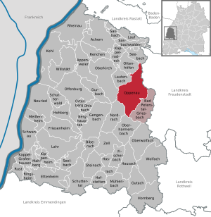
| Location of the city of Oppenau in the Ortenau district | ||
  |
||

Oppenau is a town in the Renchtal , located in the central Black Forest . It is located at the confluence of the Lierbach and Rench at an altitude of 260 to 1055 meters. The closest communities are out of the valley Lautenbach and Oberkirch , in the valley Bad Peterstal-Griesbach . You can reach Freudenstadt via the Oppenauer Steige . The wooded district - 58.5 square kilometers and thus 80 percent of the district area is forested - is bordered by larger Black Forest mountains, including Moos (877 meters), Braunberg (877 meters) and Kniebis (960 meters). The area between the Allerheiligen waterfalls , the Schliffkopf (1055 meters) and the Vogelskopf (1056 m) in the north of the district is part of the Black Forest National Park .
geography

City structure
The town of Oppenau with the communities of Ibach, Lierbach, Maisach and Ramsbach, which were independent until the 1970s, still includes 101 villages, hamlets, Zinken, farms and houses.
Lost places
In the district of Lierbach is the lost village Rotenfels, in the district of Maisach is the lost village of Frauenberg. Gone up in Oppenau are the houses list Matt, the Outbound or renamed village Deiffelsmühle located in the district Oppenau. The village of Reinhartshofen has risen up in Ramsbach, while the villages of Altneustein and Letschenmühle have been lost in the Ramsbach district.
history

In the 12th century, the village of Noppenouwe ("Aue des Noppo") emerged from an agricultural settlement and was under the Zähringer until 1218 . After their extinction, the rulership in the rear Renchtal was severely fragmented, and from this time the Allerheiligen Monastery, founded in 1192 in the Lierbachtal, had significant political, cultural and religious influence on Oppenau . In 1316 the Renchtal came into the hands of the bishops of Strasbourg . The coat of arms of Prince-Bishop Louis René Édouard de Rohan-Guéméné on the upper city gate, originally built in the 16th century, still reminds of this today .
Around 1319, the Strasbourg bishops founded the fortified place of the same name at the exit of the Lierbach valley around Friedberg Castle and granted it city rights . The reason was to secure the property against efforts by Württemberg and Baden to expand their influence in the Renchtal. Both places were conveniently located on the trade route from Strasbourg to Ulm and benefited from the fact that overnight quarters had to be taken on the way over the Kniebis opening credits and often also at night.
Friedberg and Noppenouwe grew together, the name Oppenau, derived from Noppenouwe, became commonplace for both settlements in the 15th century. The complete structural unification of the two places did not take place until 1770 through the so-called Beilerstadt .
From 1592 to 1664 the city was pledged to the dukes of Württemberg . During this time the great fire of 1615 fell. The reconstruction in the Swabian style planned by Heinrich Schickhardt still shapes the cityscape in the upper part of the city with the gable sides facing the street .
In 1668 a Capuchin monastery was built in Oppenau , which was dissolved in 1804. Subsequently, today's town center with Allmendplatz as the central square was built at this point by building the town hall and the parish church of St. Johannes .
In 1803, Oppenau fell to the Grand Duchy of Baden as part of the Reichsdeputationshauptschluss . After the Second World War , Oppenau was part of the federal state of Baden and has belonged to Baden-Württemberg since 1952 .
On October 12, 1990, an assassination attempt on CDU politician Wolfgang Schäuble was carried out during an election campaign in Oppenau , and he was seriously injured.
Incorporations

As a result of the community reform, the formerly independent parishes of Ibach, Lierbach, Maisach and Ramsbach came to Oppenau on July 1, 1974 .
Ibach

The district of Ibach and the district of Lochberg, which belongs to Ibach, are located in the Renchtal between Oppenau and Bad Peterstal on the B 28 . In Locherberg the pass road branches off over the Lochbergwasen to Oberharmersbach and Nordrach . 738 inhabitants live on the 1798 hectare area (as of 2014). The coat of arms of Ibach shows in silver on a green shield base a black trunk, green deciduous tree with a black bird on it.
Lierbach

Lierbach , with 233 inhabitants (as of 2014) the smallest district, stretches along the valley of the same name and is strongly characterized by resettler farms. The district area of 2151 hectares - almost a third of the total area - consists of 90 percent forest. The coat of arms of Lierbach shows a blue sloping beam in silver, symbolizing the river.
Maisach
.png)
The Maisach valley branches off from the Lierbachtal shortly after Oppenau. The Bad Antogast spa, known in the 18th and 19th centuries and visited by the nobility , belongs to Maisach . With 267 inhabitants (as of 2014) on two-fifths of the municipal area consisting of forest, Maisach is also strongly characterized by isolated farms. The talking coat of arms shows in silver a black and silver titmouse looking forward on a forked black branch. According to calculations by the Karlsruhe University of Technology and Economics, Maisach is the central location in Baden.
Ramsbach

Ramsbach is out of the valley from Oppenau im Renchtal and is crossed by the B 28. There are also two stops on the Appenweier – Bad Griesbach railway line . The district has grown rapidly in recent years due to the identification of several new development areas and in 2014 had 965 inhabitants. The district area is 1576 hectares. The coat of arms shows, in silver, a black saw on a black bar-wise saw frame and thus refers to the fact that Ramsbach is the location of many sawmills to this day . There is an industrial area and sports facilities in the village.
Population development

The population of Oppenau developed as follows over the centuries:
- 1299: Seven farms and houses are documented
- 1590: The city has 78 citizens, i.e. around 500 inhabitants
- 1615: The city fire hits 655 residents, 96 of them citizens
- 1803: About 1600 inhabitants, of which 242 citizens
- 1900: about 2000 inhabitants
- 1961: 5093 inhabitants, of which 818 in Ibach, 394 in Lierbach, 327 in Maisach, 2965 in Oppenau and 589 in Ramsbach
- 1970: 5430 inhabitants, of which 914 in Ibach, 732 in Lierbach, 332 in Maisach, 3133 in Oppenau and 679 in Ramsbach
- 1991: 5499 inhabitants
- 1995: 5323 inhabitants
- 2000: 5116 inhabitants
- 2005: 5141 inhabitants
- 2010: 4850 inhabitants
- 2015: 4681 inhabitants
Religions
The population of Oppenau is predominantly Catholic . There is also a Protestant community.
politics
Administrative community
Oppenau is the seat of the Upper Renchtal administrative association , which also includes the neighboring Bad Peterstal-Griesbach.
Municipal council
The municipal council in Oppenau consists of the elected honorary councilors and the mayor as chairman. The mayor is entitled to vote in the municipal council. The local election on May 26, 2019 in Oppenau led to the following final result. The turnout was 64.1% (2014: 56.8%).
| CDU | 9 seats | 49.7% | (2014: 58.2%, 11 seats) |
| Independent voter association Oppenau eV | 10 seats | 50.3% | (2014: 41.8%, 8 seats) |

mayor
Uwe Gaiser has been mayor since October 29, 2017. He succeeds Thomas Grieser, who died in August and who headed the city for 31 years.
coat of arms
|
|
Blazon : "In silver pointy roofed one surrounded by an open-topped battlements ramparts red Torburg on unterhalbem, sharpened, red base with two and beknauften battlements towers, black lancet windows upstairs and reduced, stufengiebligem central building, in an open Spitz portal, increased by a black lancet windows."
The coat of arms has been used since Friedberg Castle was built in 1319. |
Economy and Infrastructure
Due to its location, Oppenau is characterized by agriculture, in particular forestry and the production of spirits are of great importance. There are also companies in the vehicle construction and chemical industry as well as mechanical engineering. The tourism is also an important economic factor.
traffic
Oppenau is on the federal road 28 ( Kehl –Ulm) and the Renchtalbahn ( Offenburg - Bad Griesbach ), on which the Ortenau S-Bahn (OSB) operates. Railway stations and stops in the city are (counting down the valley) Lochberg, Ibach, Oppenau, Ramsbach Birkhof and Ramsbach Höfle.
Rail traffic is supplemented by bus traffic. Buses are the only public connection to the Lierbachtal and in the direction of Kniebis / Schwarzwaldhochstraße .
The nearest international airports are Strasbourg , Stuttgart , Karlsruhe / Baden-Baden and Basel-Mulhouse .
Oppenau is on the Franco-German Heinrich-Schickhardt- Strasse, a tourist route that connects cities where the Württemberg builder has left visible traces.
Educational institutions
In the city center there is a primary and secondary school with a community school . There are also three Roman Catholic kindergartens .

Leisure and sports facilities
- Leisure pool
- several ski lifts in the vicinity
- Günter Bimmerle Hall
- Small level
- Haldenhof sports complex
- Four launch sites for hang-gliders and paragliders in the cardinal directions east, northeast, west and south.
- Stoppomat , permanent timing system that starts in Oppenau on the Kniebis-Steige
Culture and sights

theatre
Annual open-air productions in the nave of the Allerheiligen monastery. Mainly pieces with a general historical (medieval) or local background are performed here.
Museums
Renchtäler Heimatmuseum in the town hall
Buildings
Are particularly worth seeing
- the upper city gate (also Lierbacher Tor)
- the ruins of the former Premonstratensian Abbey of Allerheiligen with the nearby Allerheiligen waterfalls
- the Catholic parish church of St. Johannes Baptist on Allmendplatz, built according to plans by Friedrich Weinbrenner
- the ruin Bärenburg in the district of Ramsbach
- the Röschenschanze built in 1796 , located at the end of the Oppenauer Steige near the Black Forest High Road
- the Schwedenschanze from the 16th century, also at the end of the Oppenauer Steige, on the other side of the street, exactly opposite the Röschenschanze
- the “Buchkopfturm Oppenau”, a 28 m high observation tower at 921 m on the Renchtalsteig east of Maisach. Before its inauguration on May 14, 2015, the eight-storey tower clad with silver fir wood was called the “ White Fir Tower”.
Regular events
Annual events include:
- Alemannische Fasent organized by the Narrenzunft Oppenauer Schlappgret
- The festival week of classical music with four international classical concerts every year, always in the last week in September.
- Concerts by the town and parish bands as well as local music associations, especially accordion and singing.
- City festival around the Oppenauer Allmend , held annually since 1986.
Personalities
Honorary citizen
- 1860: Ignaz Oppenauer Edler von Oppenau (born November 8, 1806 in Krumau / Böhmen; † January 18, 1878 in Oppenau), Austrian colonel, ennobled in 1853, who retired in 1859 and settled in Oppenau due to coincidental identical names
sons and daughters of the town
- The Constance Hanß , a notorious robber in Württemberg, was born in Oppenau in 1759
- Ludwig Huber (born December 10, 1889 in Ibach; † January 18, 1946 there), farmer and politician (NSDAP), member of the Reichstag
- Ernst Haas (born November 4, 1901 in Oppenau; † April 25, 1979 in Villingen-Schwenningen), lawyer and politician (SPD), member of the state parliament
- Robert Huber (born September 8, 1964) former U-15 national soccer player
- Günter Spinner (* 1972), lawyer and judge at the Federal Labor Court
Others
- Adolf Katsch (1813–1906), author of fraternity songs, lived and died in Oppenau .
literature
- Börsig, Josef: History of the Oppenauer Valley , Oppenau o. J. (approx. 1950)
- Frank Flechtmann: When the Gauleitung has their carpets carried into the bunker, planes come. SD reports in an idyll. [At the end of the war 1944–1945 in Strasbourg and Allerheiligen, “Gau Baden-Elsaß”.] In: Die Ortenau , publications of the Historical Association for Central Baden, 75th annual volume, Offenburg 1995, pp. 477–514.
Individual evidence
- ↑ State Statistical Office Baden-Württemberg - Population by nationality and gender on December 31, 2018 (CSV file) ( help on this ).
- ^ The state of Baden-Württemberg. Official description by district and municipality. Volume VI: Freiburg region Kohlhammer, Stuttgart 1982, ISBN 3-17-007174-2 . Pp. 400-405
- ^ Federal Statistical Office (ed.): Historical municipality directory for the Federal Republic of Germany. Name, border and key number changes in municipalities, counties and administrative districts from May 27, 1970 to December 31, 1982 . W. Kohlhammer, Stuttgart / Mainz 1983, ISBN 3-17-003263-1 , p. 513 .
- ↑ Thomas Liebscher, Where is the center of Baden ?, in: Der Sonntag, May 24, 2015, p. 3.
- ↑ Grieser remains mayor of the small Renchtal town of Oppenau ., In the Badische Zeitung of January 18, 2010.
- ↑ Baden-Württemberg State Archives
- ^ Book head tower Oppenau-Maisach on the website of Renchtal Tourismus GmbH
- ↑ Weißtannenturm is now called Buchkopffturm on baden online from April 22, 2015, accessed on December 7, 2017
Web links

Achern | Appenweier | Bad Peterstal-Griesbach | Berghaupten | Biberach | Durbach | Ettenheim | Fischerbach | Friesenheim | Gengenbach | Gutach (Black Forest Railway) | Haslach im Kinzigtal | Hausach | Hofstetten | Hohberg | Hornberg | Kappel-Grafenhausen | Kappelrodeck | Throat | Kippenheim | Lahr / Black Forest | Run | Lautenbach | Mahlberg | Meißenheim | Mühlenbach | Neuried | Nordrach | Oberharmersbach | Oberkirch | Oberwolfach | Offenburg | Ohlsbach | Oppenau | Ortenberg | Ottenhöfen in the Black Forest | Renchen | Rheinau | Ringsheim | Rust | Sasbach | Sasbachwalden | Schuttertal | Schutterwald | Schwanau | Seebach | Seelbach | Steinach | Willstätt | Wolfach | Zell am Harmersbach
Rheinau (municipality-free area)