
Ortenau district
| coat of arms | Germany map |
|---|---|

|

Coordinates: 48 ° 28 ' N , 7 ° 56' E |
| Basic data | |
| State : | Baden-Württemberg |
| Administrative region : | Freiburg |
| Region : | Southern Upper Rhine |
| Administrative headquarters : | Offenburg |
| Area : | 1,860.81 km 2 |
| Residents: | 429,479 (Dec. 31, 2018) |
| Population density : | 231 inhabitants per km 2 |
| License plate : | OG, BH , KEL, LR, WOL |
| Circle key : | 08 3 17 |
| NUTS : | DE134 |
| Circle structure: | 51 municipalities |
| Address of the district administration: |
Badstrasse 20 77652 Offenburg |
| Website : | |
| District Administrator : | Frank Scherer (independent) |
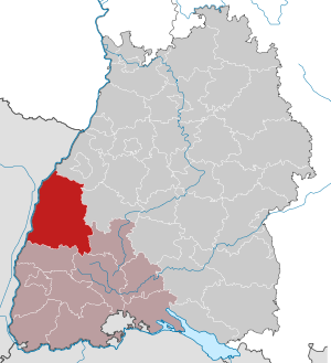
| Location of the Ortenau district in Baden-Württemberg | |
  |
|
The Ortenaukreis is the largest district in Baden-Württemberg . It belongs to the southern Upper Rhine region in the Freiburg administrative region . The district town and at the same time the most populous city in the Ortenau district is Offenburg .
geography
location
The Ortenaukreis is part of the Upper Rhine Plain , the Middle Black Forest and the Northern Black Forest , the highest point of which, the Hornisgrinde , is in the northeastern district. The Ortenaukreis is cut by many valleys, including the Schutter , Kinzig , Rench and Acher river valleys , all four right tributaries of the Rhine , with the Kinzig being the most important Black Forest river in the district.
Neighboring areas
The Ortenaukreis borders in a clockwise direction in the north on the districts of Rastatt , Freudenstadt , Rottweil , Schwarzwald-Baar-Kreis and Emmendingen . In the west, the Rhine forms the natural border with the Grand Est region (until 2015 Alsace ) in France with the local arrondissements Sélestat-Erstein and Strasbourg within the Département Bas-Rhin .
nature
The Ortenaukreis has the following 23 nature reserves . According to the protected area statistics of the State Institute for the Environment, Measurements and Nature Conservation Baden-Württemberg (LUBW), 3504.74 hectares of the district are under nature protection, that is 1.89 percent.
The nature reserves often extend over the boundaries of several municipalities; partly also over the area of other districts (Schliffkopf, Elzwiesen, Taubergießen and Schlossberg-Hauberg).
| Nature reserve | Size (in hectares ) |
District share (in hectares) |
Municipality, district |
|---|---|---|---|
| Grinding head | 1396.3 | 520.1 | City of Oppenau (districts Lierbach and Maisach), Ottenhöfen, Seebach |
| High Geisberg | 21.0 | 21.0 | Schuttertal |
| Sauscholle | 29.2 | 29.2 | Neuried (district Ichenheim) |
| Langwald | 34.5 | 34.5 | Hohberg (district Niederschopfheim) |
| Glaswaldsee | 22.0 | 22.0 | Bad Peterstal-Griesbach (districts Schapbach and Bad Peterstal) |
| Gottschlagtal-Karlsruhe ridge | 151.0 | 151.0 | Ottenhöfen in the Black Forest |
| Forest mats | 58.9 | 58.9 | Schwanau (Wittenweier district) |
| Rosswört | 13.4 | 13.4 | City of Kehl (district Leutesheim) |
| Elzwiesen | 410.8 | 129.3 | Ringsheim, Rust (Baden) |
| Hornisgrinde beaver cauldron | 95.1 | 95.1 | Sasbach (district Obersasbach), Sasbachwalden |
| Hinterwörth-Laast | 82.4 | 82.4 | City of Rheinau (Baden) |
| Altwasser Goldscheuer | 6.1 | 6.1 | City of Kehl (district Goldscheuer) |
| Middle ground helmets | 103.0 | 103.0 | City of Rheinau (Baden) (districts Helmlingen and Freistett) |
| Valley hump | 37.5 | 37.5 | City of Offenburg (district Rammersweier) |
| Salmengrund | 185.0 | 185.0 | Meißenheim, Neuried (Baden) |
| Acid mats | 18.5 | 18.5 | Ettenheim |
| Thomasschollen | 219.5 | 219.5 | Meißenheim, Schwanau |
| Sundheimer reason | 20.2 | 20.2 | City of Kehl, Willstätt |
| Eckenfels | 32.1 | 32.1 | City of Oppenau |
| Dew pouring | 1697.0 | 1349.7 | Kappel-Grafenhausen, Rust (Baden) |
| Underwater mats | 324.4 | 324.4 | Hohberg, Schutterwald, Neuried (Baden) |
| Schlossberg-Hauberg | 107.0 | 17.2 | Hornberg |
| Dörlinbacher Grund-Münstergraben | 34.7 | 34.7 | Ettenheim, Ringsheim, Kappel-Grafenhausen |
| total | 5099.6 | 3504.8 |
history
The district takes its name from the historic Ortenau landscape .
The Ortenaukreis was formed by the district reform on January 1, 1973 by the union of the districts of Kehl (excluding the northern municipalities), Lahr , Offenburg and Wolfach (excluding the eastern municipalities) and the southern part of the Bühl district.
On July 1, 1978, there was an exchange of areas between the cities of Schiltach ( Rottweil district ) and Wolfach .

The current district area belonged to different dominions until 1803 and then came to Baden , which initially retained the existing division of offices (Achern, Appenweier, Rheinbischofsheim, Ettenheim, Gengenbach, Haslach, Hornberg, Kork, Mahlberg, Lahr, Oberkirch, Offenburg and Wolfach). But the first offices were dissolved as early as 1813. Further dissolutions followed, until at the end of the 19th century only the districts of Achern, Bühl, Ettenheim, Kork (from 1881 Kehl), Lahr, Oberkirch, Offenburg and Wolfach existed. In 1924, the administrative districts were converted into administrative districts, with Ettenheim joining Lahr and Achern joining Bühl. In 1936 the Oberkirch district was merged with the Offenburg district and some border adjustments were carried out in the other districts. For the time being, border changes were carried out for the last time in 1939 under the four districts that still existed until they were incorporated into the Ortenau district in 1973.
After the municipal reform has been completed, the Ortenaukreis comprises 51 municipalities and an uninhabited municipality-free area. Of the 51 municipalities, 16 have city rights and five of them have the status of a " large district town " (Achern, Kehl, Lahr / Black Forest, Oberkirch and Offenburg). The largest city is Offenburg, the smallest municipality is Seebach.
Population development
The population figures are census results (¹) or official updates from the Baden-Württemberg State Statistical Office ( main residences only ).
|
|
politics
The district is administered by the district council and the district administrator.
District council
The district council is elected for five years by those entitled to vote in the district. The local elections on May 26, 2019 led to the following result.
The election results of previous elections are shown in the following overview:
| Parties and constituencies | % 2019 |
Seats 2019 |
% 2014 |
Seats 2014 |
% 2009 |
Seats 2009 |
% 2004 |
Seats 2004 |
% 1999 |
Seats 1999 |
% 1994 |
Seats 1994 |
% 1989 |
Seats 1989 |
|
|---|---|---|---|---|---|---|---|---|---|---|---|---|---|---|---|
| CDU | Christian Democratic Union of Germany | 33.62 | 29 | 39.78 | 36 | 38.65 | 36 | 43.3 | 38 | 43.7 | 39 | 39.0 | 37 | 42.0 | 43 |
| FW | Free voters Ortenau | 22.04 | 19th | 19.87 | 18th | 22.28 | 22nd | - | - | - | - | - | - | - | - |
| Flat share * | Electoral associations | - | - | - | - | - | - | 21.6 | 20th | 19.8 | 18th | 17.2 | 18th | 16.8 | 18th |
| SPD | Social Democratic Party of Germany | 14.6 | 12 | 18.76 | 15th | 17.38 | 14th | 20.4 | 17th | 24.5 | 21st | 26.1 | 23 | 25.9 | 25th |
| Green | Alliance 90 / The Greens | 15.05 | 12 | 11.12 | 9 | 9.35 | 7th | 7.7 | 6th | 6.2 | 5 | 9.0 | 8th | 6.9 | 6th |
| FDP | Free Democratic Party | 5.57 | 4th | 5.28 | 5 | 9.86 | 8th | 6.6 | 5 | 4.7 | 4th | 6.0 | 5 | 6.7 | 6th |
| left | Left list Ortenau / Die Linke | 2.16 | 2 | 2.12 | 2 | 2.49 | 1 | - | - | - | - | - | - | - | - |
| AfD | Alternative for Germany | 6.24 | 5 | 2.01 | 1 | - | - | - | - | - | - | - | - | - | - |
| OIL | Ortenau list | 0.72 | 0 | 1.04 | 1 | - | - | - | - | - | - | - | - | - | - |
| REP | The Republicans | - | - | - | - | - | - | - | - | 1.1 | - | 2.3 | 1 | 1.7 | 1 |
| Otherwise. | Others | - | - | - | - | - | - | 0.4 | - | - | - | 0.5 | - | - | - |
| total | 100 | 83 | 100 | 87 | 100 | 88 | 100 | 86 | 100 | 87 | 100 | 92 | 100 | 99 | |
| voter turnout | 48.7% | 50.2% | 52.0% | 54.3% | 66.1% | 61.0% | |||||||||
* WG: Voting associations, as the results from 1989 to 2004 cannot be broken down to individual groups of voters.
District administrators
The district administrator is the legal representative and representative of the district as well as the chairman of the district council and its committees. He heads the district office and is an official of the district. His area of responsibility includes the preparation of the district council meetings and its committees. He calls meetings, chairs them and implements the resolutions passed there. He has no voting rights in the committees . His deputy is the first state official.
|
|
coat of arms
|
|
Blazon : “In silver a red armored and red tongued black double-headed eagle with a gold breast shield; in it the silver armored St. George on a black horse with a redsaddlecloth, killinga green lindworm with a lance. " |
| Justification of the coat of arms: The coat of arms is linked to the coat of arms of the canton of Ortenau of the imperial knighthood. The eagle also stands for the formerly free imperial cities of Offenburg, Gengenbach, Zell am Harmersbach, the free imperial valley Harmersbach as well as for the Upper Austrian provincial bailiwick of Ortenau before the areas fell to Baden in 1805. (The coat of arms was awarded on August 31, 1973; however, the coat of arms had been in use by the district of Offenburg since 1962). |
Economy and Infrastructure
In the Future Atlas 2016 , the district was ranked 116th out of 402 rural districts, municipal associations and independent cities in Germany, making it one of the regions with “future opportunities”. In the 2019 edition, it was ranked 157 out of 401.
The Ortenaukreis is strongly rural, in particular the cultivation of fruit and wine as well as forestry in the Black Forest valleys characterize the region, in which, thanks to the favorable climate and the fertile soil, there are still relatively many small and part-time agricultural businesses. The best-known wine locations within the Ortenau wine-growing region (not identical to the district) are Zell-Weierbach , Durbach , Gengenbach, Ortenberg, Sasbachwalden , Kappelrodeck , Waldulm and Oberkirch .
Industrial and commercial focuses are in Offenburg (printing and media industry, mechanical engineering), Achern, Kehl (steel production and caravan construction), Oberkirch (automotive supplier industry, paper production), Lahr (logistics) and in the Kinzigtal (mechanical engineering).
The Ortenaukreis is, together with most of the municipalities of the district - as well as the IHK Südlicher Oberrhein, the Chamber of Crafts Freiburg, the cities of Bühl and Schiltach and the municipality of Bad Rippoldsau-Schapbach - shareholders of the Offenburg / Ortenau economic region (WRO). The WRO guarantees economic development, location marketing and public relations for the Ortenau. Around 140 companies from the region are represented on the WRO's economic advisory board.
The Europa-Park, the largest amusement park in German-speaking countries, is located in the municipality of Rust . With around 3,600 employees, the park is also one of the largest employers in the region. Indirectly, up to 8,500 additional jobs will be secured, especially in the region.
traffic
The district town of Offenburg is the hub of rail traffic. It was connected from Karlsruhe to the north-south axis of the Baden State Railroad as early as 1844 ; In 1845 the journey continued in the direction of Freiburg. In addition, there was a branch in Appenweier to Kehl as early as 1844; but the Rhine crossing to Strasbourg did not take place until 1861. In 1866, the Black Forest Railway began operating from Offenburg in the Kinzig valley up to Hausach; the difficult mountain route to Villingen followed in 1873 and the branch line to Wolfach in 1878; it reached Schiltach in 1886.
The Renchthal Railway Company started operating the Appenweier - Oppenau line in 1876; this was only extended 50 years later by the Deutsche Reichsbahn to Bad Peterstal in 1926 and to Bad Griesbach in 1933.
Shortly before the turn of the century, a few branch lines were built. The company Vering & Waechter opened the Achern - Ottenhöfen Achertalbahn in 1898 and the Harmersbachtalbahn Biberach - Zell am Harmersbach - Oberharmersbach-Riersbach in 1904. Finally, the narrow-gauge railway followed from the banks of the Rhine across from the Alsatian town of Rheinau to Ettenheimmünster at the foot of the Black Forest; it crossed the north-south axis in Orschweier. In the twenties it was partially shut down and the rest re-tracked.
The area between the banks of the Rhine and the edge of the mountains was opened up by a network of narrow-gauge steam trams. The main owner was the Strasbourg tram company , which in 1898 connected its network on the left bank of the Rhine in Alsace with an electric tram from Strasbourg - Kehl to the Baden power supply; From Kehl since 1892 one line ran down the Rhine towards Rastatt, the other in 1898 to the southeast to Offenburg with the junction in Altenheim to Ottenheim. There was a connection to the Ottenheim Rheinufer - Lahr - Seelbach line of the Lahr tram company . This also connected the center of the city of Lahr with the state train station outside of Dinglingen, although a short branch line from there to the city train station had been operated by the Lahrer Eisenbahngesellschaft since 1865 .
This extensive narrow-gauge network, which was operated under the company Mittelbadische Eisenbahnen AG after the First World War , disappeared along with a few other railways within twenty years between 1950 and 1970. The railway network, which is 305 km long at most, has lost almost a third of its size.
In the summer of 1998, the Ortenau-S-Bahn GmbH (OSB), which belongs to the Südwestdeutsche Landesverkehrs-AG (SWEG), began to operate local rail services on some important Deutsche Bahn routes from the Offenburg junction. In 2014 the Ortenau-S-Bahn was completely merged with the SWEG, and since then the SWEG has operated the OSB lines.
The local public transport in the Ortenaukreis is organized in the tariff association Ortenau TGO, to which nine companies have come together. 60 lines with a total length of 1492 km are offered. The tariff extends beyond the border to Strasbourg, so that the Strasbourg tram can also be used with a TGO ticket.
The federal autobahn 5 Basel - Karlsruhe and several federal highways, including the B 3 Basel - Karlsruhe, the B 28 Strasbourg - Freudenstadt and the B 33 Offenburg - Konstanz, run through the district . The B 500 (" Black Forest High Road ") forms the north-eastern boundary of the district. Furthermore, several state and district roads open up the Ortenaukreis.
The Lahr Airport provides air links of the district, where only commercial and cargo flights will be operated. The Strasbourg airport is not far from the district center.
District facilities
The Ortenaukreis supports the following vocational schools :
- Commercial schools in Achern
- Vocational schools (BSK) Kehl (vocational and commercial school)
- Commercial schools Lahr
- Commercial schools Offenburg
- Commercial and home economics schools Wolfach
- Commercial and home economics schools in Achern
- Commercial schools in Hausach
- Commercial schools in Lahr
- Commercial schools Offenburg
- Vocational schools in Mauerfeld (home economics school) Lahr
- Home and agricultural schools Offenburg
- Forestry training center Mattenhof Gengenbach
- Agricultural College Offenburg
- Badische Malerfachschule Lahr
In addition, the district is responsible for the following special needs education and advice centers :
- Carl-Sandhaas-Schule with kindergarten in Haslach im Kinzigtal (focus on intellectual development)
- Georg-Wimmer-Schule with school kindergarten in Lahr (special focus on intellectual development)
- Hansjakob school with kindergarten in Offenburg (focus on intellectual development)
- Astrid-Lindgren-Schule Willstätt-Hesselhurst (specialization in intellectual development)
- Helme Heine School Offenburg (special focus on physical and motor development)
- Maiwaldschule Achern-Wagshurst (specialization language)
- Brothers Grimm School Lahr (special focus on language)
- Renchtal School for the Language Disabled Oberkirch (special focus on language)
- Special education and advice center for students in long-term hospital treatment, Offenburg
The Ortenaukreis is also carrier of the five district hospitals Achern, Oberkirch, Ettenheim, Wolfach and Kehl and the clinics Lahr / Black Forest and Offenburg, each as Eigenbetrieb be out of the county. Other in-house operations are the Ortenau nursing and care home, the Black Forest open-air museum Vogtsbauernhof and waste management.
cities and communes
(Residents on December 31, 2018)
Cities
Agreed administrative communities and municipal administration associations
|
Communities
Community-free area
|
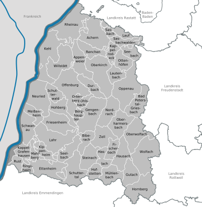  |
License Plate

On January 1, 1973, the district was assigned the OG distinctive sign , which had been valid for the Offenburg district since July 1, 1956 . It is still issued today.
Until the 1990s, vehicles from the old districts received special identification numbers:
| area | Letters | numbers |
|---|---|---|
| Old district of Offenburg | A to Z | 1 to 999 |
| AA to ZZ | 1 to 99 | |
| PA to VZ | 100 to 999 | |
| Old district of Lahr | AA to EZ | |
| Altkreis Kehl | HA to KY | |
| Old district Wolfach | LA to NZ |
Due to the liberalization of the license plates , the distinguishing characters KEL , LR , WOL and since March 30th 2015 also BH have been available since March 31, 2014 .
See also
- Hanauerland
- Vidin Oblast (partner region in Bulgaria)
literature
- R. Metz: Construction and image of the landscape in the Ortenau . In: The Ortenau . Volume 40, 1960, pp. 16-55.
- Landesarchivdirektion Baden-Württemberg (Ed.): The state of Baden-Württemberg. Official description by district and municipality . Volume VI: Freiburg administrative region . Stuttgart 1982, ISBN 3-17-007174-2 .
Web links
- Official website of the Ortenaukreis
- Literature from and about the Ortenaukreis in the catalog of the German National Library
Individual evidence
- ↑ State Statistical Office Baden-Württemberg - Population by nationality and gender on December 31, 2018 (CSV file) ( help on this ).
- ↑ LUBW protected area statistics ( Memento from January 20, 2015 in the Internet Archive )
- ^ Federal Statistical Office (ed.): Historical municipality directory for the Federal Republic of Germany. Name, border and key number changes in municipalities, counties and administrative districts from May 27, 1970 to December 31, 1982 . W. Kohlhammer, Stuttgart / Mainz 1983, ISBN 3-17-003263-1 , p. 512 ff .
- ^ Result of the district council election for the Ortenaukreis from the ortenaukreis website.
- ↑ statistik.baden-wuerttemberg.de ( memento from September 3, 2014 in the web archive archive.today ) Distribution of votes in the district elections 1989–2009
- ↑ statistik.baden-wuerttemberg.de ( Memento from September 3, 2014 in the web archive archive.today ) Distribution of seats in the district elections 1989–2009
- ↑ Zukunftsatlas 2016. Archived from the original ; accessed on March 23, 2018 .
- ↑ PROGNOS future atlas. Handelsblatt, accessed on December 10, 2019 .
- ↑ Europa-Park. Retrieved July 4, 2019 .
- ↑ State Statistical Office Baden-Württemberg - Population by nationality and gender on December 31, 2018 (CSV file) ( help on this ).
Alb-Danube District | Baden-Baden | Biberach | Lake Constance district | Boeblingen | Breisgau-Upper Black Forest | Calw | Emmendingen | Enzkreis | Esslingen | Freiburg im Breisgau | Freudenstadt | Göppingen | Heidelberg | Heidenheim | Heilbronn (Land) | Heilbronn (city) | Hohenlohekreis | Karlsruhe (State) | Karlsruhe (city) | Constance | Loerrach | Ludwigsburg | Main-Tauber district | Mannheim | Neckar-Odenwald district | Ortenaukreis | Ostalbkreis | Pforzheim | Rastatt | Ravensburg | Rems-Murr-Kreis | Reutlingen | Rhein-Neckar District | Rottweil | Schwäbisch Hall | Schwarzwald-Baar district | Sigmaringen | Stuttgart | Tübingen | Tuttlingen | Ulm | Waldshut | Zollernalb district