
Rhein-Neckar district
| coat of arms | Germany map |
|---|---|

|

Coordinates: 49 ° 24 ' N , 8 ° 41' E |
| Basic data | |
| State : | Baden-Württemberg |
| Administrative region : | Karlsruhe |
| Region : | Rhine-Neckar |
| Administrative headquarters : | Heidelberg |
| Area : | 1,061.7 km 2 |
| Residents: | 547,625 (Dec. 31, 2018) |
| Population density : | 516 inhabitants per km 2 |
| License plate : | HD |
| Circle key : | 08 2 26 |
| NUTS : | DE128 |
| Circle structure: | 54 parishes |
| Address of the district administration: |
Kurfürstenanlage 38–40 69115 Heidelberg |
| Website : | |
| District Administrator : | Stefan Dallinger ( CDU ) |
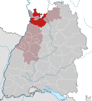
| Location of the Rhein-Neckar-Kreis in Baden-Württemberg | |
 .svg) |
|

The Rhein-Neckar-Kreis is the most populous district in Baden-Württemberg and the fifth largest in Germany in terms of population . It is located in the northwest of the country in the Karlsruhe administrative district and belongs to the Rhine-Neckar metropolitan region .
The seat of the district is Heidelberg , which is itself an urban district and does not belong to the district. The largest city in the district is the large district town of Weinheim .
geography
location
The Rhein-Neckar-Kreis is part of the Upper Rhine Plain , the western Kraichgau and the southern Odenwald . The landscape on the western edge of the Odenwald from Wiesloch northwards via Heidelberg and Weinheim to Darmstadt is known as the Bergstrasse , one of the warmest areas in Germany. To the east is the Brunnenregion tourist area . The district borders directly on Hesse and Rhineland-Palatinate ( Brühl (Baden) - Altlußheim / Altrip - Speyer ) and also has an exclave that is only two kilometers from Bavaria ( Badisch-Schöllenbach / Kirchzell -Breitbach).
Neighboring areas
The Rhein-Neckar-Kreis borders in a clockwise direction in the north, starting with the districts Bergstrasse , Odenwaldkreis (both in Hesse), Neckar-Odenwald-Kreis , Heilbronn and Karlsruhe (all in Baden-Württemberg). In the west, the Rhine forms the border with the federal state of Rhineland-Palatinate with the independent city of Speyer and the Rhein-Pfalz-Kreis , with the exception of the Kollerinsel on the left bank of the Rhine , which belongs to the municipality of Brühl and thus to the Rhein-Neckar-Kreis. Furthermore, the Rhein-Neckar district borders on the urban districts of Mannheim and Heidelberg.
A narrow strip that belongs to Hesse extends into the district from the north to the Neckar . These are the communities of Neckarsteinach and Hirschhorn (Neckar), which are part of the Bergstrasse district, as well as the community-free area of Michelbuch .
Division of space

According to data from the State Statistical Office , as of 2015.
history
The Rhein-Neckar-Kreis was created by the district reform in Baden-Württemberg on January 1, 1973 . At that time, the old districts of Heidelberg and Mannheim were combined with the northern half of the old district of Sinsheim and the municipality of Lindach of the old district of Mosbach to form the Rhein-Neckar district. On January 1, 1975, Ziegelhausen was outsourced to the Heidelberg district . On April 1, 1976, the Kümmelbacher Hof was separated from the city of Heidelberg and incorporated into the city of Neckargemünd . After a small correction of the boundary to the Neckar-Odenwald district , which came into effect on January 1, 1977, the district was given its current form. Historically, the Rhein-Neckar district played an important role even before the district reform in the 1848/49 revolution . From here, decisive impulses for the struggle for freedom and democracy emanated.
The old districts of Heidelberg, Mannheim and Sinsheim go back to the former Baden district offices, which were changed several times in the course of history and were transferred to districts in 1936/1939. At the same time, the urban districts of Heidelberg and Mannheim were created in 1939. Since then, both cities no longer belong to the respective district areas, but remained the seat of the respective district administration until 1972.
After the district reform, Heidelberg became the seat of the new Rhein-Neckar district. After the municipal reform has been completed, this will include 54 municipalities, including 17 cities and of these, in turn, six “ major district cities ” ( Hockenheim , Leimen , Schwetzingen , Sinsheim , Weinheim and Wiesloch ). The largest city is Weinheim, the smallest municipality is Heddesbach. With a total of 54 cities and municipalities , the Rhein-Neckar district is just behind the Alb-Donau district , which has 55 cities and municipalities. In Weinheim, Ladenburg, Neckargemünd, Sinsheim and Wiesloch, in addition to the numerous offices in Heidelberg, there are branch offices of the district office.
Population development
The population figures are census results (¹) or official updates from the Baden-Württemberg State Statistical Office. Only main residences were taken into account.
|
|
politics
The district is administered by the district council and the district administrator.
District council
The district council is elected for five years by those entitled to vote in the district. The local elections on May 26, 2019 led to the following preliminary results. The official final result will be announced by the State Statistical Office towards the end of the year.

- Results of past district elections
| Parties and constituencies |
% 2014 |
Seats 2014 |
% 2009 |
Seats 2009 |
% 2004 |
Seats 2004 |
% 1999 |
Seats 1999 |
% 1994 |
Seats 1994 |
% 1989 |
Seats 1989 |
|
| CDU | Christian Democratic Union of Germany | 34.17 | 36 | 34.0 | 38 | 39.7 | 45 | 42.1 | 46 | 33.6 | 38 | 35.3 | 50 |
| SPD | Social Democratic Party of Germany | 22.29 | 23 | 23.3 | 24 | 24.3 | 23 | 26.3 | 25th | 29.3 | 31 | 29.7 | 38 |
| FW | Free voters | 19.19 | 20th | 17.7 | 17th | - | - | - | - | - | - | - | - |
| Flat share | Electoral associations | - | - | - | - | 17.2 | 16 | 17.6 | 16 | 15.9 | 17th | 15.2 | 20th |
| GREEN | Alliance 90 / The Greens | 13.83 | 15th | 12.2 | 12 | 11.9 | 12 | 8.8 | 8th | 13.2 | 14th | 10.3 | 13 |
| FDP | Free Democratic Party | 5.95 | 6th | 8.5 | 9 | 6.9 | 7th | 4.9 | 5 | 5.6 | 6th | 6.9 | 9 |
| LEFT | The left | 3.72 | 4th | 2.9 | 3 | - | - | - | - | - | - | - | - |
| WL | Weinheimer List | 0.84 | 1 | - | - | - | - | - | - | - | - | - | - |
| REP | The Republicans | - | - | - | - | - | - | - | - | 1.3 | 1 | 0.8 | 1 |
| Otherwise. | Other ; u. a. Weinheim Plus | - | - | 0.4 | - | - | - | 0.3 | - | 1.1 | 1 | 1.7 | 1 |
| total | 100.0 | 105 | 100.0 | 103 | 100.0 | 103 | 100.0 | 100 | 100.0 | 108 | 100.0 | 132 | |
| voter turnout | 51.45% | 53.6% | 55.9% | 55.9% | 70.6% | 66.8% | |||||||
- WG: Voter associations, as the results from 1989 to 2004 cannot be broken down into individual groups of voters.
District Administrator
The district council elects the district administrator for a term of eight years. He is the legal representative and representative of the district as well as chairman of the district council and its committees. He heads the district office and is an official of the district. His area of responsibility includes the preparation of the meetings of the district council and its committees. He calls meetings, chairs them and implements the resolutions passed there. He has no voting rights in the committees . His deputy is the first state official.
The district administrators of the Rhein-Neckar-Kreis since 1973:
- 1973: Georg Steinbrenner , official administrator
- 1973–1986: Albert Neckenauer
- 1986–2010: Jürgen Schütz ( CDU )
- since 2010: Stefan Dallinger ( CDU )
coat of arms
Description : Split: in front in blue a silver wavy bar covered with a wavy black thread; behind in gold a red crowned, red-tongued and red-armed black lion
(Coat of arms awarded November 5, 1975)
Significance: The coat of arms takes into account the geographical location and the historical dominance of the district and the formerly independent communities. The divided wave bar symbolizes the Rhine and Neckar , which gave the district its name. The electoral-Palatinate lion symbolizes the former affiliation of the majority of today's district area to the Electorate of Palatinate . The colors of the lion have been swapped compared to the original coat of arms in order to comply with the heraldic color rule .
District partnerships
The Rhein-Neckar-Kreis maintains a partnership with the Hungarian Somogy county .
Economy and Infrastructure


The industrial structure is diverse with numerous companies in the metalworking and chemical industries (e.g. Freudenberg in Weinheim), including numerous medium-sized companies. The service sector is concentrated in the large cities that do not belong to the Rhein-Neckar district, but there are also important companies in the district, such as B. the software company SAP in Walldorf and St. Leon-Rot or the financial services provider MLP and Heidelberger Druckmaschinen in Wiesloch. Agriculture and forestry are also strongly represented in the rural parts of the district. In the Rhine Valley ( St. Leon-Rot , Schwetzingen ) is one of the main areas for growing is asparagus in Germany.
In the future atlas 2016 , the Rhein-Neckar-Kreis was ranked 31st out of 402 rural districts, municipal associations and independent cities in Germany, making it one of the regions with “very high future prospects”.
traffic
The federal autobahn 5 Basel - Frankfurt , federal autobahn 61 Venlo - Hockenheim and the federal autobahn 6 Saarbrücken - Mannheim - Nuremberg , which intersect at the Walldorf interchange, run through the district area , several federal highways , including the B 3 , Basel-Frankfurt, the B 39 , the B 37 and B 45 as well as state roads.
In the district area, the network of the S-Bahn RheinNeckar went into operation on December 14, 2003, which opens up the entire Rhine-Neckar area as far as the Palatinate and southern Hesse. The connection to the Karlsruhe Stadtbahn network is to be expanded. The Rhein-Neckar-Verkehr GmbH (RNV), before March 1, 2005 the Upper Rhine Railway (OEG), connects Mannheim , Heidelberg and Weinheim on a circular route . Trams of RNV also drive from Heidelberg to Leimen and Eppelheim . BRN , RNV and SWEG supply the Heidelberg area with a relatively dense bus network.
District facilities
The Rhein-Neckar-Kreis is responsible for the following vocational schools : Theodor-Frey-Schule (industrial and commercial school) Eberbach , Ehrhart-Schott-Schule (industrial school) Schwetzingen , Friedrich-Hecker-Schule (industrial school) Sinsheim , Hans-Freudenberg -Schule (commercial school) Weinheim , Hubert-Sternberg-Schule (commercial school) Wiesloch , Carl-Theodor-Schule (commercial school) Schwetzingen, Max-Weber-Schule (commercial school) Sinsheim, Johann-Philipp-Reis-Schule (commercial school) School) Weinheim, Johann-Philipp-Bronner-School (commercial school) Wiesloch, Louise-Otto-Peters-Schule (home economics school) Hockenheim with branch office Wiesloch, Albert Schweitzer school (home economics school) Sinsheim and Helen Keller school ( Home economics school) Weinheim, furthermore the following special education and advice centers : Comenius School Schwetzingen (special focus on intellectual development), Steinsberg school with school kindergarten Sinshe im (focus on intellectual development), Maria Montessori School with Kindergarten Weinheim (focus on mental development) and Martinsschule Ladenburg (focus on physical and motor development).
The Rhein-Neckar-Kreis maintains hospitals, retirement and nursing homes and geriatric rehabilitation clinics. These were previously in the form of a self operation performed. Since January 1, 2006, these facilities have been operated by the “GRN Health Centers Rhein-Neckar non-profit GmbH”. Specifically, these are the district hospitals Eberbach, Schwetzingen, Sinsheim and Weinheim, the district nursing homes Schwetzingen and Weinheim and the geriatric rehabilitation clinic Weinheim. There is also a nursing school at each of the Schwetzingen district hospitals.
cities and communes
(Residents on December 31, 2018, area)
Agreed administrative communities and municipal administration associations
|
|
  |
License Plate
On January 1, 1973, the district was assigned the HD distinctive sign , which had been valid for the Heidelberg district since July 1, 1956 . It is still issued today.
Until the 1990s, vehicles from the sub-circles were given special identification numbers:
| area | Letters | numbers |
|---|---|---|
| Heidelberg sub-district | AA to NL | 100 to 999 |
| YES to NL | 1000 to 9999 | |
| Mannheim district | NM to TU | 100 to 999 |
| TU to NM | 1000 to 9999 | |
| Weinheim district | TV up to XP | 100 to 999 |
| TV up to XP | 1000 to 9999 | |
| Sinsheim district | XR to ZZ | 100 to 999 |
| ZZ to XR | 1000 to 9999 |
literature
- Adolf M. Hirn, Gabriele Süskind (ed.), Jürgen Schütz (ed.): The Rhein-Neckar district . Stuttgart 1991, ISBN 3-8062-0597-3 .
- The state of Baden-Wuerttemberg - official description according to districts and municipalities (in eight volumes); Edited by the Baden-Württemberg State Archives Department; Volume V: Karlsruhe District; Stuttgart 1976, ISBN 3-17-002542-2 .
- Land survey office Ba-Wü: Leisure map of the Neckartal-Odenwald Nature Park - Mannheim-Heidelberg. F 513, ISBN 3-89021-606-4 . Scale 1:30 000. 2005. The connection map to the east ( Eberbach to Buchen ) is called: Freizeitkarte Naturpark Neckartal-Odenwald - Mosbach. F 514. ISBN 3-89021-607-2 .
- 50 years of the district council. Elections, MPs, balance sheets 1946–1996 . Heidelberg 1996, ISBN 3-932102-00-2 . Volume 1 of the book series of the RNK building blocks on district history .
- Albert Neckenauer: The office of the district administrator through the ages . Published from the estate of the first district administrator of the Rhein-Neckar district, Heidelberg 1999, ISBN 3-932102-05-3 . Volume 4 of the book series of the RNK building blocks on district history .
- Working group of the archives in the Rhein-Neckar-Dreieck (ed.): The Rhine-Neckar area and the revolution of 1848/49 - revolutionaries and their opponents . regional culture publisher, ISBN 3-929366-64-9 .
- Landesvermessungsamt BW (Ed.): Rhein-Neckar-Kreis. Cycling map , ISBN 978-3-89021-733-8 .
- David Depenau: The Ortsnecknames in Heidelberg, Mannheim and the Rhein-Neckar-Kreis. From Bloomäuler, Lellebollem and Neckarschleimer . regional culture publishing house, ISBN 978-3-89735-205-6 .
Web links
Individual evidence
- ↑ a b Statistisches Landesamt Baden-Württemberg - Population by nationality and gender on December 31, 2018 (CSV file) ( help on this ).
- ↑ Survey of land according to type of actual use in 2015
- ^ Federal Statistical Office (ed.): Historical municipality directory for the Federal Republic of Germany. Name, border and key number changes in municipalities, counties and administrative districts from May 27, 1970 to December 31, 1982 . W. Kohlhammer, Stuttgart / Mainz 1983, ISBN 3-17-003263-1 , p. 486 f .
- ↑ The Rhein-Neckar-Kreis turns 40 October 18, 2013 www.rnz.de
- ↑ - ( Memento from February 27, 2016 in the Internet Archive ) Result of the district election 2014
- ↑ - ( Memento from February 27, 2016 in the Internet Archive ) Result of the district election 2009
- ↑ [1] http://www.statistik.baden-wuerttemberg.de/SRDB/Tabelle.asp?R=KS226&H=Wahlen&U=04&T=02043010 ( Memento from September 5, 2014 in the web archive archive.today ) Distribution of votes in the 1989 district elections -2009
- ↑ [2] http://www.statistik.baden-wuerttemberg.de/SRDB/Tabelle.asp?R=KS226&H=Wahlen&U=04&T=02043020 ( Memento from September 5, 2014 in the web archive archive.today ) Distribution of seats in the 1989 district elections -2009
- ↑ Future Atlas 2016. Archived from the original on April 25, 2019 ; accessed on March 23, 2018 .
Alb-Danube District | Baden-Baden | Biberach | Lake Constance district | Boeblingen | Breisgau-Upper Black Forest | Calw | Emmendingen | Enzkreis | Esslingen | Freiburg im Breisgau | Freudenstadt | Göppingen | Heidelberg | Heidenheim | Heilbronn (Land) | Heilbronn (city) | Hohenlohekreis | Karlsruhe (State) | Karlsruhe (city) | Constance | Loerrach | Ludwigsburg | Main-Tauber district | Mannheim | Neckar-Odenwald district | Ortenaukreis | Ostalbkreis | Pforzheim | Rastatt | Ravensburg | Rems-Murr-Kreis | Reutlingen | Rhein-Neckar District | Rottweil | Schwäbisch Hall | Schwarzwald-Baar district | Sigmaringen | Stuttgart | Tübingen | Tuttlingen | Ulm | Waldshut | Zollernalb district
Independent cities: Frankenthal (Pfalz) | Heidelberg | Landau in the Palatinate | Ludwigshafen am Rhein | Mannheim | Neustadt an der Weinstrasse | Speyer | Worms
Districts: Bad Dürkheim | Mountain road | Germersheim | Neckar-Odenwald | Rhine-Neckar | Rhine-Palatinate | Southern Wine Route