
Spechbach (Kraichgau)
| coat of arms | Germany map | |
|---|---|---|

|
Coordinates: 49 ° 21 ' N , 8 ° 53' E |
|
| Basic data | ||
| State : | Baden-Württemberg | |
| Administrative region : | Karlsruhe | |
| County : | Rhein-Neckar district | |
| Height : | 197 m above sea level NHN | |
| Area : | 8.52 km 2 | |
| Residents: | 1699 (December 31, 2018) | |
| Population density : | 199 inhabitants per km 2 | |
| Postal code : | 74937 | |
| Area code : | 06226 | |
| License plate : | HD | |
| Community key : | 08 2 26 086 | |
| Address of the municipal administration: |
Hauptstrasse 35 74937 Spechbach (Kraichgau) |
|
| Website : | ||
| Mayor : | Guntram Zimmermann | |
| Location of the community of Spechbach (Kraichgau) in the Rhein-Neckar district | ||
  |
||

Spechbach is a municipality in the Rhein-Neckar district in Baden-Württemberg .
geography
Geographical location
Spechbach is located on the border between the small Odenwald and Kraichgau , 21 km southeast of Heidelberg , between Heidelberg, Sinsheim and Mosbach . The district of Spechbach essentially comprises the Spechbachtal of the same name as well as the ridges on both sides and lies at an altitude of about 160 to 330 meters.
Neighboring communities
The community borders in the east on Epfenbach , in the south-east on Neidenstein , in the south on Eschelbronn , in the south-west on Meckesheim and in the west and north on Lobbach . The municipality is a member municipality in the municipality administration association Elsenztal, the seat of which is the municipality of Meckesheim.
Community structure
The Neumühle house belongs to Spechbach. The Kleinspechbach desert is located in the municipality .
history
In Roman times there was a settlement known as Vicus Nediensis in today's Spechbacher district , which may already have been of Celtic origin and which at the time of the Romans served as a farmyard behind the Limes . There is no evidence of the Roman settlement from the time after 250, so that the place was probably not repopulated until the Carolingian times in the high Middle Ages.
The modern settlement of Spechbach developed on the lower right-hand slope of the Spechbach valley. The place was first mentioned in 1246 with the naming of a Heidelberg citizen "Conradus de Spehbach". The place name (1337 Spechbach, 1349 Spehsbach) is probably derived from the woodpecker . The place initially belonged to the Hohenstaufen empire around Wimpfen and came with the Meckesheimer Zent 1330 under Palatinate suzerainty. The Lords of Weinsberg appeared as local lords in 1325 on the occasion of an inheritance division , in 1401 the Neidenstein branch of the Lords of Venningen , later also the Lords of Helmstatt , the Landschad von Steinach , the Barons von Zandt , the von Üxküll family and others, with the Venningen always again had the dominant influence in the place until the mediatization of the imperial knighthood, although there were also several local lords at times.
In the 15th and 16th centuries, a distinction was made between Großspechbach and Kleinspechbach, the latter essentially consisting of a mill on Lobbach and was devastated in the Thirty Years War . Spechbach was initially a street village with farmsteads along the main street and the church with a walled cemetery above it. There were 33 case goods in the village , which, however, had already been severely divided by the late 18th century. The whole place was initially laid out on manorial land. From 1838 the Venningen house sites were released into rural property. The growth in the 19th century mainly led to a further densification of the town center, while another residential area was only created along the road to Lobenfeld . The other new development areas of the place were not developed until after 1951.
Spechbach belonged to the Palatinate Office Dilsberg until 1803 , then to the Baden District Office Neckargemünd . The manor also had its own office in Eichtersheim from 1807 to 1813 . In 1857 Spechbach came to the Eberbach district office in Baden , in 1863 to the Heidelberg district office , with which it was transferred to the Heidelberg district in 1938 and to the Rhine-Neckar district in 1973 .
politics
Administrative association
The community belongs to the local administration association Elsenztal with seat in Meckesheim.
Municipal council
The municipal council in Spechbach has ten members. The municipal council consists of the elected voluntary councilors and the mayor as chairman. The mayor is entitled to vote in the municipal council.
The 2019 local elections led to the following result (in brackets: difference to 2014):
| FWV | 4 seats (−1) |
| Independent list Spechbach | 3 seats (+3) |
| CDU | 2 seats (−1) |
| SPD | 1 seat (−1) |
The turnout was 70.3% (+6.2).
mayor
The mayor is directly elected for eight years. Guntram Zimmermann has been in office since 1996. Werner Braun was elected as his successor in 2020.
coat of arms
The blazon of the coat of arms reads: A black woodpecker sitting in silver on a blue wavy bar, above it two diagonally crossed red lilies.
The coat of arms goes back to a court seal from 1705. It was designed in 1921 by the General State Archives in Karlsruhe . The woodpecker symbolizes the place name while speaking. The lily rods come from the coat of arms of the Lords of Venningen , who had shares in the local government since 1401.
The flag is blue and white and was awarded in 1981 by the Rhein-Neckar-Kreis district office.
BürgerEnergiedorf

Since February 16, 2012, the municipality has been a federal pilot municipality in the federal pilot project for the creation of an integrated district concept. Since the goal is never the pure use of bioenergy, but rather the way to energy self-sufficiency is sought together with the citizens, the project was called “BürgerEnergiedorf”. 150 citizens are involved in the project. The development of its own heat supply based on renewable energies is planned for Spechbach. The heat is to be generated centrally in a heating center and distributed via a local heating network.
Attractions
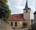
The center of Spechbach is characterized by the neighboring Protestant and Catholic churches. The Catholic Church of St. Martin is the older of the two churches and goes back to a St. Martin's Church that already existed in the Middle Ages. The church was reformed in 1561, used as a simultaneous church from 1699 and returned to the Catholics in 1707 in the course of the church's division . A new nave was built in 1767 and extended to the west in 1828. On the outer wall is the ornate tombstone of Victor Kirchgessner (1830–1898), pastor in Weingarten and Walstetten, from 1880 in Spechbach. The Protestant church was built in 1776. In the center of the village, on the site of a previous building, there is also the historic town hall built in 1865 and renovated in 1964, the Catholic parish hall from 1912 and several half-timbered houses and historic inns such as the Gasthof Sonne from 1796. In Spechbach there is also a Roman fountain that connects to Römerstrasse from Ladenburg to the Roman Limes border town Osterburken . However, almost nothing can be seen of the actual ground monument without professional guidance.

Catholic Church
Evang. church

Catholic parish hall

town hall


Economy and Infrastructure
economy
Until the 1960s, the main source of income for the people of Spechbach was agriculture. In 1960 there were 55 full-time farms of which only one still exists today. In 2007 there were still eight part-time businesses.
Infrastructure
Spechbach has been a federal pilot community since February 16, 2012. With its inclusion in the federal pilot project "Energy-efficient urban renovation - energy-efficient district supply" by the Federal Ministry of Transport, Building and Urban Development and the KfW Reconstruction Loan Corporation, the municipality and its project "BürgerEnergiedorf Spechbach" are among five pilot projects in Baden-Württemberg.
traffic
The state road L 530 and the district road K 4180 run through Spechbach. The southern edge of the district is also grazed by the K 4279 between Epfenbach and Eschelbronn. The federal highway 45 runs seven kilometers to the west, which allows connection to the federal highway 6 in the south . The bus routes 754 and 796 create a connection to the surrounding communities. The next train station is in Eschelbronn. Spechbach belongs to the tariff area of the Rhein-Neckar transport association .
education
Confessional schools have been documented in Spechbach since the 17th century, and a community schoolhouse from 1880. Since December 1966 there has only been one elementary school , all secondary schools are in the surrounding communities and cities.
literature
- State Archive administration Baden-Württemberg in connection with d. Cities and districts Heidelberg u. Mannheim (Hrsg.): The city and districts Heidelberg and Mannheim: Official district description.
- Vol. 1: General part. Karlsruhe 1966
- Vol. 2: The city of Heidelberg and the municipalities of the district of Heidelberg. Karlsruhe 1968
- Adolf M. Hirn, Gabriele Süskind (ed.), Jürgen Schütz (ed.): The Rhein-Neckar district. Stuttgart 1991, ISBN 3-8062-0597-3 .
Individual evidence
- ↑ State Statistical Office Baden-Württemberg - Population by nationality and gender on December 31, 2018 (CSV file) ( help on this ).
- ^ The state of Baden-Württemberg. Official description by district and municipality. Volume V: Karlsruhe district Kohlhammer, Stuttgart 1976, ISBN 3-17-002542-2 , pp. 362–363.
- ↑ http://www.spechbach.de/rathaus/gemeinderat
- ↑ State Statistical Office of Baden-Württemberg: Municipal elections 2019, Spechbach ; Spechbach municipality : municipal council election 2019 ; accessed May 31, 2019.
- ↑ The municipality's website , accessed on November 22, 2010
- ↑ https://www.rnz.de/nachrichten/region_artikel,-buergermeisterwahl-spechbach-werner-braun-holt-sofort-die-absolute-mehrheit-_arid,522651.html
- ^ Herwig John, Gabriele Wüst: Wappenbuch Rhein-Neckar-Kreis. Ubstadt-Weiher 1996, ISBN 3-929366-27-4 , p. 120.
- ↑ Baden-Württemberg State Statistical Office ( page no longer available , search in web archives ) Info: The link was automatically marked as defective. Please check the link according to the instructions and then remove this notice.
Web links

Altlußheim | Angelbachtal | Bammental | Brühl | Dielheim | Dossenheim | Eberbach | Edingen-Neckarhausen | Epfenbach | Eppelheim | Eschelbronn | Gaiberg | Heddesbach | Heddesheim | Heiligkreuzsteinach | Helmstadt-Bargen | Hemsbach | Hirschberg an der Bergstrasse | Hockenheim | Ilvesheim | Ketch | Ladenburg | Laudenbach | Gluing | Lobbach | Malsch | Wall | Meckesheim | Mulhouse | Neckarbischofsheim | Neckargemünd | Neidenstein | Neulußheim | Nut hole | Oftersheim | Plankstadt | Rauenberg | Reichartshausen | Reilingen | Sandhausen | Schönau | Schönbrunn | Schriesheim | Schwetzingen | Sinsheim | Spechbach | St. Leon-Rot | Waibstadt | Walldorf | Weinheim | Wiesenbach | Wiesloch | Wilhelmsfeld | Zuzenhausen