
Neckarbischofsheim
| coat of arms | Germany map | |
|---|---|---|

|
Coordinates: 49 ° 18 ' N , 8 ° 58' E |
|
| Basic data | ||
| State : | Baden-Württemberg | |
| Administrative region : | Karlsruhe | |
| County : | Rhein-Neckar district | |
| Height : | 171 m above sea level NHN | |
| Area : | 26.41 km 2 | |
| Residents: | 4040 (December 31, 2018) | |
| Population density : | 153 inhabitants per km 2 | |
| Postal code : | 74924 | |
| Area code : | 07263 | |
| License plate : | HD | |
| Community key : | 08 2 26 055 | |
| LOCODE : | DE NKB | |
City administration address : |
Alexandergasse 2 74924 Neckarbischofsheim |
|
| Website : | ||
| Mayor : | Thomas Seidelmann (Active.List) | |
| Location of the city of Neckarbischofsheim in the Rhein-Neckar district | ||
  |
||

Neckarbischofsheim is a small town in the Rhein-Neckar district in Baden-Württemberg . It belongs to the European metropolitan region of Rhine-Neckar (until May 20, 2003 the Lower Neckar region and until December 31, 2005 the Rhine-Neckar-Odenwald region ).
geography
Geographical location
Neckarbischofsheim is located in the Krebsbach valley shortly before its confluence with the Schwarzbach in the transition area from Kraichgau to Kleiner Odenwald in northern Baden-Württemberg, around 25 km southeast of Heidelberg and northwest of Heilbronn . The district is at an altitude of 166 to 298 meters above sea level. The municipality is part of the Brunnenregion tourism region .
City structure
Untergimpern , which was incorporated in 1971, belongs to the city of Neckarbischofsheim .
The village of Helmhof , which was founded in 1712 and was only partially managed by Neckarbischofsheim until 1951 , the hamlet of Heidäcker, the villages of Helmhofer Forsthäuser, Krixenberghof, housing estate at the federal railway station and housing estate at the lime works and the house Pulvermühle are also located in the district of Neckarbischofsheim within the boundaries of 1970 . There are also the desert areas of Christlingen, Hinter- and Vorderschendlingen.
history
Early settlement and first mention in 988
Various small finds in the Krebsbachtal within today's city limits suggest that there was an almost 2000-year-old settlement, presumably of Roman origin . From the Frankish settlement period around 500 AD, grave fields have been preserved in the neighboring Bargen .
The place was first mentioned in a document in 988: King Otto III. granted the Bishop of Worms fishing and hunting rights in Biscovesheim in the deed of wild animals . In 1223 King Henry VII donated the nearby Great Forest (today: Stadtforst) to the city of Wimpfen , which has been cultivating it to this day. The local lords had the place as an imperial or Worms fief .
Imperial Knighthood City of Bischofsheim

In the High Middle Ages, the lords of Helmstatt held local authority. Your coat of arms (shield with a raven figure crowned by a helmet with buffalo horns) is preserved on numerous buildings. Diether von Helmstatt received the castle in Neckarbischofsheim from Rudolf von Habsburg as an imperial fief. Raban I. von Helmstatt († 1334) already held the place as a Worms fief and is considered the progenitor of Bischofsheim. Around 1330 the Helmstatt exchanged the patronage rights of the Johanneskirche (today's Church of the Dead ) with the diocese of Worms for property in Grombach and the Oberbiegelhof . On June 24, 1378 Weiprecht I (called Wiprecht the Old) acquired von Helmstatt for 5000 guilders from his brother Raban III. its “part of the castle and town of Bischofsheim”. In the purchase letter that has been received, Bischofsheim was first mentioned in a document as a " city ", the fortification of which the Krebsbach had been diverted and the medieval city with Johanneskirche (13th century), town hall, tithe barn and bakery (mentioned around 1380), Marienkapelle (1386) as a moat and Alexander Castle (after 1420). The so-called Hinterstadt was created through the expansion of the city in the late 15th century, of which the high tower still testifies as a defense tower. In the early 15th century, the local rulers also approved a council of twelve citizens and twelve lay judges, who represented the interests of the Bischofsheimer vis-à-vis the local authorities .

During the Peasants' War in 1525 there were also unrest in and around Bischofsheim, although in 1524 the local lords Philipp Jakob, Alexander and Philipp had already made contractual concessions to the residents. After the unrest in Kraichgau was put down, the Treaty of 1524 was declared null and void on June 28, 1525 in Bischofsheim and the Council of Twenty-Four, which had been in place for over a hundred years, was dissolved.
As early as 1517, Nikolaus Renneysen, a Protestant preacher, was there. In 1525 or 1526, a new church order was presumably issued by Alexander and Philipp von Helmstatt, which initiated the reformation of the place, around the same time a Latin school was founded in the city.
An important event for the place was the Helmstatt inheritance of 1543, which Johann von Helmstatt favored with possession in Bischofsheim. His father-in-law, Philipp von Helmstatt, from the Grumbach branch of the gentlemen's family, which was widely branched at the time, had the old castle converted into a residence. At the same time, the Marienkapelle was expanded and with it the anticipation of its elevation to the town church. In 1560, the reformation of the place was formally carried out through the revised church regulations of Philipp von Helmstatt.
The main occupation in the city was agriculture in the 16th century, and all the important craftsmen were available to cover the needs, for example bricklayers, stonemasons, blacksmiths, joiners, tailors. There were three mills on site, and later a sawmill. The brickworks, where bricks were burned, is first mentioned in 1561. Since Bischofsheim was also a place of refuge for the surrounding villages, over 2000 people are said to have lived in Bischofsheim between the 15th and 17th centuries. In 1574 and 1575 the plague raged in the city. In the early 17th century, the Marienkapelle was expanded to become the town church of St. Salvator .

During the Thirty Years War , Tilly had his headquarters in the Stone House from March 6 to April 4, 1622, and it was here that preparations for the siege of Heidelberg began. However, Tilly fled after troops from the Palatinate advanced from the east to Bischofsheim on April 3, 1622. In 1634 imperial horsemen attacked, in 1638 the Croats and in 1645 the French besieged the city, which also suffered from famine and again from the plague . During the war, refugees from the surrounding unfortified villages, especially from Untergimpern, were quartered in the Alexander Castle. Numerous billeting and deaths in connection with the French invasions are documented in the last decades of the 17th century. After Sinsheim was destroyed in 1689, many people from Sinsheim also found refuge in Bischofsheim.
Around 1712, the nearby Helmhof settlement between Bischofsheim and Untergimpern in the Krebsbachtal was built , which extended partly to the Bischofsheimer district and partly in the Wimpfen forest, and whose settlers on the Bischofsheim side did not become citizens in return for labor, but became "relatives in protection". In the 18th century, Bischofsheim grew beyond the limits of the medieval fortifications. The city moats became muddy and fell dry, the city walls and, most recently, in 1826 the medieval city gates that had been preserved until then, were demolished.
Baden district town Neckarbischofsheim after 1806

In 1806, after the Napoleonic Wars, the Imperial Knights were mediated as a result of the Reichsdeputationshauptschluss and Bischofsheim came to the Grand Duchy of Baden , whereupon the name of the city was changed to "Neckarbischofsheim" because there were two other places within the Grand Duchy with the name Bischofsheim: Tauberbischofsheim and Rheinbischofsheim . Neckarbischofsheim has the Neckar in its name, although it flows around 15 km away.
In Baden, Neckarbischofsheim first came to the Waibstadt District Office in 1807 and became the seat of the Neckarbischofsheim District Office in 1810 . As a popular place of immigration, the city grew to around 2000 inhabitants by 1860, with around 260 inhabitants mostly emigrating to America during the same period. In the first half of the 19th century, the district office building (1825), forester's house, new castle (1829), new town hall (1843) and school building on the market square (1850) were built. The civil association in Bischofsheim founded the knight society in 1830 , which was based on the customs of student associations. The community consumption of beer was of central importance. If one withdrew from the compulsory feasts called tournament evenings, the window panes were thrown in as a punishment. The club, known as the casino company from February 23, 1835 , later provided financial support for the establishment of choral societies and a library.

After two bad harvests in 1846 and 1847, the Baden agricultural unrest began in Neckarbischofsheim, which is one of the origins of the revolution of 1848 . On March 3, 1848 and on the following days there were repeated riots by angry farmers against wealthy Bischofsheim Jews, who at that time were building a synagogue in the city.
The great fire of Neckarbischofsheim in the night of November 2nd to 3rd, 1859 destroyed the entire south-western third of the city (46 houses and 42 outbuildings burned down). The fire left over 300 residents temporarily homeless. Reconstruction progressed rapidly, but in some cases it probably took years. Since the fire damage was so extensive, the reconstruction did not follow the old property boundaries and streets, but the plots were re-parceled out and streets such as the southern part of Hauptstrasse , Bergstrasse or Untere Mühlbachgasse straightened or newly laid out.

In 1864 the district office Neckarbischofsheim was dissolved, and Neckarbischofsheim was added to the extended district office Sinsheim , from which the district Sinsheim emerged in 1939 . A certain industrialization of the city began with the construction of the nearby Badische Odenwaldbahn , opened in 1862 , whose wells were serviced by a Neckarbischofsheim company. A printing company was founded in 1879, the Zuck family's forge became a vehicle construction company, and later there was also a lime works, cigar and gold factory. A land consolidation created better conditions for agriculture in 1870–1880 by eliminating the strong parceling of the fields and redistributing the approximately 29,000 parcels to 9,000 parcels. In 1885, at the instigation of Mayor Neuwirth, an association to raise the city was founded. This later "beautification association" laid out footpaths, donated park benches and planted trees, as there were hopes of an elevation to the health resort.
1900–1902 the Neckarbischofsheim-Hüffenhardt branch line was opened and a hospital was built. In 1906 the Neckarbischofsheim medical column was founded, from which today's local association of the German Red Cross emerged. The city had a brisk economic development, there were numerous medium-sized companies founded. And motorization quickly replaced traditional professions.
Period of National Socialism and World War II

In the pogrom in 1938 that was the synagogue of the city destroyed. On October 22, 1940 , the last members of the Jewish community of Neckarbischofsheim, which had existed since the 17th century, were arrested by the Gestapo and deported to the Gurs camp . From 1943 the production of castle nuts for aircraft engines by the Kuntz and Weitbrecht company from Winterbach in Neckarbischofsheim was outsourced. From September 1944, there was a sub-command of the Neckarelz concentration camp , a satellite camp of the Natzweiler concentration camp , in Neckarbischofsheim . For this purpose, several accommodation and utility barracks were built in the Wiesental. At the end of March 1945 the camp was closed and the prisoners were first brought to Neckarelz and then on to Dachau. The Neckarbischofsheim-Nord station was repeatedly the target of low-flying attacks because of its importance for the war effort due to the nearby army ammunition facility in Siegelsbach and Obergimpern .
In 1939 there were 1,316 inhabitants, at the end of 1945 there were 1916. At the end of the Second World War, almost 900 displaced persons and refugees who were looking for work and accommodation came to the city. Through the settlement of several industrial companies and intensive construction activity, it was possible to cope with this task over the years.
Second half of the 20th century

In January 1946, the Franz Derscheid company from Mannheim built a sawmill in the former economic and administrative barracks of the concentration camp sub-command near the north station, for which a siding was built in 1947. Many of the nearly 900 expellees were housed in the barracks and the Bernau district of Waibstadt and the Schwarzbach settlement belonging to Neckarbischofsheim developed from there.
Further company foundations in the post-war period are a quartz oscillator factory, a stocking factory and a cardboard box factory, which up until 1988 provided 650 of the around 1,400 jobs in the city. Until 1967 there was also an agricultural school in Neckarbischofsheim. In 1966, the Neckarbischofsheim line of the von Helmstatt aristocratic family died out and many of their properties were acquired by the city in the years that followed.
When the district of Sinsheim was dissolved at the end of 1972, Neckarbischofsheim with Helmhof and Untergimpern, which was incorporated on January 1, 1971, became part of the newly created Rhein-Neckar district . As a result, the district court, forestry office and hospital were dissolved and the notarial district was reduced in size.
A comprehensive renovation of the town center took place from 1976 to 1998. In 1994, however, the city was hit by the so-called millennium flood, so that further renovation measures were necessary.
religion
44% of the population are Protestant, 32% Catholic. The Protestant parishes in Neckarbischofsheim ( St. Salvator Church and Totenkirche ), Helmhof and Untergimpern belong to the Kraichgau church district of the Evangelical Church in Baden . The parishes of Maria Königin (Neckarbischofsheim) and St. Josef (Untergimpern) belong to the pastoral care unit Waibstadt in the Kraichgau dean's office of the Archdiocese of Freiburg .
politics

Administrative association
The municipality belongs to the municipal administration association Waibstadt.
Municipal council
The parish council normally has 14 members who are elected in a fake suburb election; the core town of Neckarbischofsheim is represented by 10 councils, the districts of Helmhof and Untergimpern by 2 councils each. In addition, the mayor is the voting chairman.
Since the local elections in 2019 , the local council has 16 members with 2 compensation seats; the election led to the following result:
| Joint list of FWV and SPD | 6 seats |
| CDU | 5 seats |
| Active list | 5 seats |
mayor
Tanja Grether prevailed in the 2012 mayoral election. She took office on August 1, 2012.
- 1949–1974: Albert Kumpf
- 1974–1990: Günter Burkhardt
- 1990-2004: Rolf Geinert ( SPD )
- 2004–2012: Hans-Joachim Vogt
- 2012–2020: Tanja Grether
- from 2020: Thomas Seidelmann
coat of arms
The blazon of the coat of arms reads: A bishop with a silver alb , red cloak with a silver collar and gold clasp, gold-edged red miter and black shoes, in his right hand holding a slanted golden crook with the crook to the left, standing in silver on a green ground , in holding an open golden book on the left.
The coat of arms dates back to a court seal from 1766, the talking pointed to the place name. Today's colors were not determined until 1950, coinciding with the reassignment of city rights that were revoked in the 1930s.
The flag is red and white and was awarded by the Interior Ministry in 1963.
Town twinning
Neckarbischofsheim has had a partnership with the French city of La Chapelle-Saint-Luc ( Aube department ) since 1971 and with the Russian city of Pereslavl-Zalessky since 1992 .
Population development
On January 26, 1859, the 2010 Baden census counted residents, 1683 of whom were Protestants, in 392 families. The increase since 1855 was 63.
On June 1, 2017 Neckarbischofsheim with the districts of Helmhof and Untergimpern had a total of 4058 inhabitants (Neckarbischofsheim 2903, Helmhof 584, Untergimpern 571).
Culture and sights
Museums
Neckarbischofsheim has a local museum in the pentagonal tower .
Architectural monuments


Over the centuries, Neckarbischofsheim has preserved a number of architectural monuments that are well worth seeing and the remains of a medieval fortification that reflect a rich historical past:
- The old castle goes back to the castle mentioned in 1274 and is the oldest surviving building in Neckarbischofsheim. It got its present shape through renovations under Philipp von Helmstatt in the 16th century. The Helmstatt - Neipperg alliance coat of arms above the entrance to the stair tower and the bay window with historic leaded glazing are particularly ornate on the outside . In 1977 historical wall paintings from the 15th and 16th centuries were uncovered in the knight's hall . The knight's hall is now used as a wedding room, and there is a local history museum in the remaining rooms of the building. Nothing is left of the former outbuildings of the old castle, only a Renaissance-era magnificent gate from 1590, which is attributed to the sculptors Adam Wagner or Jakob Müller from Heilbronn, is still in the castle park.
- Next to the old castle , the new stone house was probably built in the area of the outer bailey in the late 14th century , which was later supplemented by side wings, but was then torn down in 1829 and replaced by today's new castle , which has been a hotel since September 2001.
- The Alexander Castle was first mentioned in 1545 and is the youngest of the three Neckarbischofsheimer castles. In the 19th and 20th centuries, the house was an office building, household and agricultural school, and later a branch of the Raiffeisen cooperative . Since 1997 it has been the city hall.

Magnificent gate in the castle park

Helmstatt epitaph

Burial chapel


- The Neckarbischofsheimer Totenkirche is the original parish church of the place, which has been documented since the 14th century, in which there are over 40 historical tombs of the Lords of Helmstatt. The Helmstatt Chapel is also located in the new cemetery .
- Of the medieval city fortifications with walls, city gates and several towers, only the pentagonal high tower , which was built in 1448 as part of the second expansion of the city and was rebuilt in its present form in 1726, is the only reminder today . At times the tower served as a city prison.
- The city wall , two other towers and some city gates can still be traced from the remains of the wall. The synagogue of the Jewish community, which was destroyed in 1938 and which today is commemorated by a plaque and a bronze menorah, was located on the city moat outside the city wall on the site of the former city mill .

High tower, outside with loopholes

Synagogue memorial plaque in front of the remains of the city wall
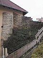
Remnants of a city tower wall


- The Protestant town church of St. Salvator goes back to a Marienkapelle from 1386, was extended by the tower in 1543 and received its nave from 1610 to 1612. After the new building of the nave, the church was called templum salvatoris (Church of the Redeemer) and raised to the parish church. The three Renaissance portals and the ornate alabaster pulpit inside are remarkable. The neighboring Protestant parsonage is the birthplace and later place of work of the local poet Adolf Schmitthenner .
- The Catholic Church of Mary Queen was completed in 1955. Before it was built, Catholic masses had been held in the Church of the Dead , but this became too small for the community that had grown after the Second World War.
- The New Apostolic Church is also a recent building.

Pulpit of St. Salvator

St. Salvator's south portal

Evang. Rectory


- The tithe barn next to the town church was built in 1570 and has been a Protestant parish hall since it was renovated in 1989.
- The old town hall , built in 1843, was the town hall until 1997.
- Jacob's fountain from the 16th century, renovated in 1831.
- Rentamthaus, built in 1577, renovated in 1797.
- Gasthaus Zum Löwen, half-timbered building from the 16th century
- District office building, built in 1825, today a pharmacy
- The gold factory is an Art Nouveau factory building that was built in 1910/11 by a Pforzheim jewelry company and used by a moldings factory from 1937.

Old Town Hall
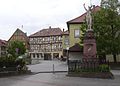
Marketplace with historical half-timbered house

Historical building


There are also several architectural monuments in the districts, including a church from 1892 in Helmhof and the historic Evangelical and Catholic church there in Untergimpern, as well as a building used as a synagogue from 1807 to 1883.

Church in Helmhof

Catholic Church Untergimpern

Evangelical Church Untergimpern


leisure
The vast forests, which often come right up to the city, invite you to take walks on well-developed paths. The "Forsthaus", located in the middle of the 600 hectare forest, is a worthwhile destination. An indoor and an outdoor swimming pool operated by the gymnastics club, two sports facilities, a shooting range and riding facility as well as a bowling alley are available for further leisure activities. There are several playgrounds for the youngest visitors. One of them as an adventure playground in the "stoned mountain forest" with hiking parking and barbecue facilities.
Economy and Infrastructure

traffic

As early as 1862, the Badische Schwarzbachtalbahn to Aglasterhausen was built as part of the Badische Odenwaldbahn Heidelberg – Würzburg . The Neckarbischofsheim Nord station was opened in 1887 ; 1902 the branch line to Hüffenhardt . Excursion traffic takes place on this on Sundays and public holidays from June to October; Daily traffic has ceased to exist since August 2009. The Schwarzbachtalbahn is integrated with the S51 into the network of the RheinNeckar S-Bahn , which means that connections to Heidelberg , Mannheim and partly Mainz are free.
The Kraichgau-Stromberg Castle Tour runs through Neckarbischofsheim , an approximately 52-kilometer regional cycle route that connects the town with the communities of Waibstadt and Rohrbach.
There is a connection to the Federal Motorway 6 via Sinsheim .
education
In addition to two municipal and one Protestant kindergarten there is a modern training center with a primary school and the Adolf-Schmitthenner - high school and two gyms. In the late year 2012 the technical school for social affairs ( Johannes-Diakonie Mosbach ) also settled in Neckarbischofsheim.
Personalities
Honorary citizen
- Paul Benz (since 2002)
- Peter Beisel (since 2013)
sons and daughters of the town
- Karl Mayer (1786–1870), poet
- Jakob Koppel Bamberger (1785–1864), rabbi in Heidelberg a. Worms
- Christoph Trefurt (1790–1861), lawyer and politician from Baden
- Louis Mayer (1791–1843), landscape painter
- August Mayer (1792–1812), poet of the Swabian Romanticism
- Eduard von Kraus (1818–1899), Prussian major general
- Georg Pfeiffer (1825–1900), senior bailiff in Baden
- Adolf Schmitthenner (1854–1907), pastor and local poet from Baden
- Karl Ludwig Schmitthenner (1858–1932), theologian, prelate and court dean
- Erich Gaertner (1882–1973), Lord Mayor of Osnabrück from 1927 to 1945
- Ludwig Paul Schmitthenner (1884–1963), Baden Minister of Culture ( NSDAP ) and professor of military history and politics
- Heinrich Schmitthenner (1887–1957), geographer
- Ruth Schwob-Bloch (1919–2012), painter
- Hans Benz (1921–1984), local history specialist
- Elke Brunnemer (* 1952), politician ( CDU ), member of the state parliament ( Baden-Württemberg )
- Thomas Schleh (born 1964), known as Klubbingman , DJ and dance producer
- Axel Schock (* 1965), author
literature
- Heinz Hautzinger: Neckarbischofsheim. A former official town in the northern Kraichgau and its catchment area. Heimatverein Kraichgau , Sinsheim 2005, ISBN 3-921214-34-3 .
- Villa Biscovesheim Neckarbischofsheim 988–1988. Association for home care, Neckarbischofsheim 1988, DNB 910138885 .
Individual evidence
- ↑ State Statistical Office Baden-Württemberg - Population by nationality and gender on December 31, 2018 (CSV file) ( help on this ).
- ^ The state of Baden-Württemberg. Official description by district and municipality. Volume V: Karlsruhe District. Kohlhammer, Stuttgart 1976, ISBN 3-17-002542-2 , pp. 420-422.
- ↑ Communications from the Württ. And Bad. State Statistical Office No. 2: Results of the population census on December 31, 1945 in North Baden
- ^ Federal Statistical Office (ed.): Historical municipality directory for the Federal Republic of Germany. Name, border and key number changes in municipalities, counties and administrative districts from May 27, 1970 to December 31, 1982 . W. Kohlhammer, Stuttgart / Mainz 1983, ISBN 3-17-003263-1 , p. 478 .
- ↑ 2011 census
- ↑ Main Statute Neckarbischofsheim, § 12 (PDF) ; accessed May 30, 2019.
- ↑ Baden-Württemberg State Statistical Office: Municipal elections 2019, City of Neckarbischofsheim ; City of Neckarbischofsheim: City Council Election 2019 (PDF) ; accessed May 30, 2019.
- ↑ Kraichgau-Stromberg: Castle Tour | Vacation country Baden-Wuerttemberg. Retrieved June 21, 2020 .
Web links
- City of Neckarbischofsheim
- LEO-BW, discover regional studies online , Neckarbischofsheim

Altlußheim | Angelbachtal | Bammental | Brühl | Dielheim | Dossenheim | Eberbach | Edingen-Neckarhausen | Epfenbach | Eppelheim | Eschelbronn | Gaiberg | Heddesbach | Heddesheim | Heiligkreuzsteinach | Helmstadt-Bargen | Hemsbach | Hirschberg an der Bergstrasse | Hockenheim | Ilvesheim | Ketch | Ladenburg | Laudenbach | Gluing | Lobbach | Malsch | Wall | Meckesheim | Mulhouse | Neckarbischofsheim | Neckargemünd | Neidenstein | Neulußheim | Nut hole | Oftersheim | Plankstadt | Rauenberg | Reichartshausen | Reilingen | Sandhausen | Schönau | Schönbrunn | Schriesheim | Schwetzingen | Sinsheim | Spechbach | St. Leon-Rot | Waibstadt | Walldorf | Weinheim | Wiesenbach | Wiesloch | Wilhelmsfeld | Zuzenhausen