
Upper lashes
|
Upper lashes
City of Bad Rappenau
|
|
|---|---|
 |
|
| Height : | 237 m |
| Area : | 12.68 km² |
| Residents : | 1715 (2009) |
| Population density : | 135 inhabitants / km² |
| Incorporation : | January 1, 1972 |
| Postal code : | 74906 |
| Area code : | 07268 |
Obergimpern is a village in the Heilbronn district that has belonged to the city of Bad Rappenau since January 1, 1972 .
geography
Obergimpern is located about five kilometers northwest of Bad Rappenau in the hilly landscape of the Kraichgau in the headwaters of the Krebsbach , which flows further northwest into the Schwarzbach , a tributary of the Elsenz .
history

Like some other districts of Bad Rappenau, Obergimpern was in Roman times in the then densely wooded supply area of the Roman forts of the Neckar-Odenwald-Limes . In the valley of the Krebsbach there was a Roman farmyard ( villa rustica ), the remains of which were found on the castle field. The exact origin of today's settlement of Obergimperns is unknown. No finds from the Alemannic-Franconian period are proven, so that because of this and the name of the place it is assumed that today's Obergimpern was founded between the 8th and 11th centuries. A moated castle, documented in 1368, was probably built in the castle garden around 1200 , using materials from the Roman ruins for its construction. The moated castle was abandoned early on, and the management building located southeast of the former castle on a hill, today's Obergimpern Castle , then served as a manor or tenant apartment . Only trapezoidal trenches were left of the moated castle in the 18th century and nothing left in the 19th century.
The place was first mentioned in a document in 1355 as a courtyard to the upper Guntbure . The name could denote a farm (Old High German: bur ) of the Gunto (Günther) or the fiefdom ( gunt ) of a farmer ( bure ), but could also refer to the Celtic word cumb (high valley) and describe the geographical location. In addition to the upper Guntbure , there was also the lower Guntbure , three kilometers downstream, today's Untergimpern (district of Neckarbischofsheim ). The Guntbure part of the name became Gumpern and finally Gimpern .
The earliest landlords are the noblemen of Fürfeld in 1355, who at that time pledged the farm to a Heinrich Östring, a citizen from Sinsheim . A little later, the property changed to the Lords of Strahlberg , who sold the farm in 1368 to Count Palatine Ruprecht I , who in turn gave three quarters of the property to the Lords of Helmstatt , whose Obergimperner line then resided there for over 300 years. The remainder of the quarter was with the Lords of Hirschhorn from 1359 . The parish church of St. Cyriak was first mentioned in 1496, had a branch chapel in Babstadt and became Lutheran in 1527 in the course of the Reformation in the Electoral Palatinate .

After the Helmstätter sideline died out in 1685, the majority of it came to the barons of Yrsch in 1690 along with other goods in Untergimpern and Wagenbach . The quarter of the von Hirschhorn, which died out in 1632, was awarded by the Electoral Palatinate in 1696 to Baron Franz Melchior von Wiser . The Catholic Yrsch pursued a re-Catholicization of the place and in 1690 introduced their simultaneous use for both denominations in the parish church , whereupon the branch association with Babstadt ended. In 1711 they drove the Protestant pastor Spiess out of the parsonage and appointed a Catholic pastor. However, the Catholic parish was also the mother church of the branch in Untergimpern, so that the church soon became too small for simultaneous use. In 1764 the old chapel was demolished and a larger one dedicated to St. Nepomuk church, for which gatherings had been made since 1712. The new building was also used simultaneously.
Baron Johann Carl von Yrsch (1695–1766) lived in Mannheim, but from 1740 had an estate built on the Eulenberg near Obergimpern . When his property was divided among his sons in 1762, Bernhard (1727–1778) received the Eulenberg farm, while the place with the official residence came to Johann Nepomuk von Yrsch (1736–1811). After the construction of the neighboring church in 1765/66, this led to a significant enlargement of the castle.
In 1793 there was a dispute between the Counts of Wiser and the Counts of Yrsch regarding jurisdiction in Ober- and Untergimpern. The dispute dragged on and was ultimately no longer settled, because after the dissolution of the Electoral Palatinate in 1803, the previous landlord rights were revoked, the place came under princely Leiningen rule and in 1806 became Baden . Around 1825 the purely agricultural town of Obergimpern had around 1100 inhabitants. Due to rural exodus and emigration, the number of inhabitants fell to around 950 by 1900. In 1904 the Catholic community established its own, dedicated to St. Cyriak church in the center of the village.

In the last decades of the 19th century, intensive limestone mining began in the existing quarries nearby. The raw material obtained in this way could be transported away with the Krebsbachtalbahn, which has now been built . In 1937 the Flürebrock brothers built a cement works at the Eulenbergerhof . The German Reich acquired a large part of the community forest in 1939 and built the Obergimpern-Siegelsbach ammunition plant with numerous halls and bunkers in it and in part of the Siegelsbach forest. Because of this facility, Obergimpern was repeatedly the target of enemy air raids in the spring of 1945. In March 1945 the facilities were partially blown up when the German troops withdrew. On April 13, 1946, the place had to be evacuated at short notice due to a forest fire near remaining ammunition bunkers.
In 1939 there were 949 inhabitants, at the end of 1945 there were 1093. After the Second World War, the population continued to grow due to the admission of almost 350 displaced persons , which is why new residential areas such as the Schloßfeldsiedlung (1950), Kuhnberg (1960) and Klause (1970) , built. When it was incorporated into Bad Rappenau on January 1, 1972, Obergimpern had 1,370 inhabitants.
Jewish community
Since the late 16th century, isolated Jews have been found in upper lashes. From the middle of the 18th century there was a Jewish community in Obergimpern . In 1810 a modest synagogue was built, which was damaged in October 1830 during anti-Jewish riots . Up until 1832 there were repeated riots, which were mostly triggered by demands for equal treatment in the donation of citizens' wood . The highest membership of the Jewish community in 1840 was about 110 people. In 1882 the synagogue was extensively renovated. As a result of emigration and emigration, the number of Jewish residents fell to 25 by 1925, and to 17 by 1933, of whom at least four were killed in the subsequent persecution. As early as 1930 it was often no longer possible to bring together the minyan required for a church service , so the synagogue was sold to the Catholic Church before 1938, which used the building for community work until after the Second World War. After 1962, the building was demolished because it was in disrepair and the property was divided between the surrounding properties.
coat of arms
The blazon reads: In silver on a black ground, a deciduous tree with a black trunk and a green crown of leaves.
Attractions

- The Obergimpern Castle goes back to the former farm yard of the abandoned moated castle, was enlarged in 1765/66, rebuilt in the 1860s in the classicism style and got its present form by rebuilding the roof structure in the 1960s.
- The Evangelical Church near the castle was built on the site of an older chapel in 1764. Until the construction of the Catholic Church, the church served as a simultaneous church .
- The Catholic parish church of St. Cyriak was built in 1904 according to plans by Ludwig Maier in the historicist style on Hauptstrasse. The church has largely its original interior with a pulpit, side altar, painted wooden ceiling and a painted gallery. A statue of Nepomuk is placed in front of the church.
- town hall
- To the west of Obergimpern is the Talmühle , further to the west is the Eulenberger Hof, built from 1740 on a hill above the Krebsbach valley .

Ev. Church from 1764

Catholic Church of St. Cyriak from 1904
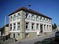
town hall

Eulenberger Hof


Individual evidence
- ↑ Neuwirth 1978
- ↑ Roland Franke: The place names of Bad Rappenau and the districts according to meaning and origin explained , in: Bad Rappenauer Heimatbote 8, 1996, pp. 36–38.
- ↑ Xaver Maxein: The history of Obergimpern Castle , in: Bad Rappenauer Heimatbote 8, 1996, p. 38.
- ↑ Communications from the Württ. And Bad. State Statistical Office No. 2: Results of the population census on December 31, 1945 in North Baden
- ↑ https://www.leo-bw.de/de_DE/web/guest/detail-gis/-/Detail/details/ORT/labw_ortslexikon/1828/Bad+Rappenau-Obergimpern
- ^ Federal Statistical Office (ed.): Historical municipality directory for the Federal Republic of Germany. Name, border and key number changes in municipalities, counties and administrative districts from May 27, 1970 to December 31, 1982 . W. Kohlhammer, Stuttgart / Mainz 1983, ISBN 3-17-003263-1 , p. 479 .
literature
- Gustav Neuwirth: History of the City of Bad Rappenau . City of Bad Rappenau, Bad Rappenau 1978
Web links

Babstadt | Bonfeld | Fürfeld | Grombach | Heinsheim | Upper lashes | Tresch blades | Wollenberg