
Siegelbach
| coat of arms | Germany map | |
|---|---|---|

|
Coordinates: 49 ° 16 ' N , 9 ° 5' E |
|
| Basic data | ||
| State : | Baden-Württemberg | |
| Administrative region : | Stuttgart | |
| County : | Heilbronn | |
| Height : | 270 m above sea level NHN | |
| Area : | 7.68 km 2 | |
| Residents: | 1626 (December 31, 2018) | |
| Population density : | 212 inhabitants per km 2 | |
| Postal code : | 74936 | |
| Area code : | 07264 | |
| License plate : | HN | |
| Community key : | 08 1 25 087 | |
| LOCODE : | DE SGL | |
| Address of the municipal administration: |
Wagenbacher Strasse 4a 74936 Siegelsbach |
|
| Website : | ||
| Mayor : | Tobias Haucap | |
| Location of the municipality of Siegelsbach in the Heilbronn district | ||
  |
||


Siegelsbach is a municipality in the Heilbronn district in Baden-Württemberg . It belongs to the Heilbronn-Franken region and the edge zone of the European metropolitan region of Stuttgart . Siegelsbach is one of the smallest communities in the district.
geography
Geographical location
Siegelsbach is located on the northern border of the Heilbronn district, a few kilometers west of the Neckar . The place is in the transition area between Kraichgau and Neckarbergland on a plateau made of shell limestone that rises slightly from south to north and is covered by Keuper sandstone in the east. Most of the district drains to the east via Tiefenbach, Siegelsbach and Mühlebachgraben into the Mühlbach-Unterlauf in the Fünfmühlental to the Neckar, a small north-westerly over the Wollenbach into the Schwarzbach , a tiny south-westerly over the Krebsbach into the Schwarzbach; After a much longer stretch of the river, this then reaches the Neckar via the Elsenz further downstream.
Neighboring communities
Neighboring cities and communities of Siegelsbach are (clockwise, starting in the south): Bad Rappenau (Heilbronn district), Hüffenhardt and Haßmersheim (both Neckar-Odenwald district ). Siegelsbach has entered into an agreed administrative partnership with Bad Rappenau and Kirchardt .
Community structure
Siegelsbach does not include any other districts, but the residential areas on the left at Wagenbacher Weg (former women's camp), Schnepfenhardter (Siegelsbacher) mill and settlement.
Division of space

According to data from the State Statistical Office , as of 2014.
history
Early history
Siegelbach is located in the hinterland of the Roman Neckar Limes . There were several Roman manors in the surrounding area , and a Roman road once ran near Siegelsbach , but there are no finds from Roman times directly in the Siegelsbach district. The first settlement therefore probably goes back to the diocese of Worms , which cleared and cultivated the area between Neckar and Elsenz in the 11th and 12th centuries. The first written mention of the place comes from the year 1258. The village was mentioned in a document on the occasion of a dispute over rights in villa Sigelspach between Konrad von Ehrenberg and the Wimpfen monastery .
In 1380, Siegelsbach came into the possession of the Electoral Palatinate , which gave the place to the Lords of Hirschhorn , who had previously acquired parts of the place. The Hirschhorn residents did not live in Siegelsbach themselves, but were represented there by a bailiff who had his seat in the Hirschhorner Hof . At that time, the Schnepfenhardter mill mentioned in 1358 and 1393 , which came into the possession of the community in the 16th century, as well as a chapel existed. In addition to the Hirschhornern, Konrad von Weinsberg and Hans der Reiche von Gemmingen also had shares in the place in the 15th century . The von Gemmingen kept their shares until the 19th century.
1523 Siegelbach was the Hirschhorn reformed . In 1554, the Lords of Hirschhorn also issued a Weistum (village order) for Siegelsbach. After the von Hirschhorn family died out in 1632, their fiefdom fell back to the Electoral Palatinate and the place was administered by the Electoral Chamber of Accounts. In 1634, Siegelsbach was burned down by Swedish troops in the Thirty Years War , and the following year the plague raged. The Electoral Palatinate had the Hirschhorner Hof repaired as the official seat after the end of the war.
Siegelbach and the Counts of Wiser
In 1698 the place came to Franz Melchior von Wiser as an Electoral Palatinate fief. The Catholic barons or from 1702 Count von Wiser were in high service in the Electorate of the Palatinate, Franz Melchior von Wiser was the Electorate of Palatinate Court Chancellor. After his death in 1702, his sons initially managed the inheritance together, but then divided it up among themselves in 1709, so that Siegelsbach with Friedelsheim and parts of Ober- and Untergimpern came to Franz Joseph von Wiser, who ran the Wiser-Siegelsbach (also Schwarz- Called Wiser). The Counts of Wiser took up their residence partly in the former Hirschhorner Hof , which they expanded in the early 18th century into the befitting castle of Siegelsbach . The Catholic landlords pursued an aggressive re-Catholicization of the predominantly Lutheran congregation and their labor and tax demands went beyond what was agreed in the wisdom of 1554. The Georgskirche was first used as a simultaneous church and then came to the Catholics in 1710. The Protestant community, whose pastor was expelled in 1711, was only able to build its own church in 1765, and there were also cemeteries that were separated according to denomination until the second half of the 20th century. The Counts of Wiser lived in Mannheim and Friedelsheim for a long time in the 18th century, where messengers were to be delivered. In 1788, Count Joseph von Wiser moved back to Siegelsbach. In 1799 the place was sacked by the French.

In 1803 the Electoral Palatinate was dissolved, and Siegelsbach came with the Oberamt Mosbach to the Principality of Leiningen , after the end of its sovereignty in 1806 to Baden and there to the district office of Neckarbischofsheim . In 1810/11 the residents refused all labor and taxes that were enforced in 1811 when the village was occupied by almost 70 dragoons. In the same year, 1811, Count von Wiser finally acquired the previous fiefdom as an allodial property through a settlement with the Princely Leiningen government against payment of 8,000 Rhenish guilders . In 1798, he inherited around 163 acres; the comparison added 248 acres, including 148 acres of forest. In the following year he dissolved the lordly office of Siegelsbach and had the place administered by the Oberamt Mosbach. At the same time, he tried to sell his forest property to foreign buyers, which was prevented by the community, which acquired the forest itself in 1813. In addition, the community acquired 16 acres of forest from the Lords of Gemmingen in 1829 . Joseph Carl Georg von Wiser also sold the castle in 1833, which after several changes of ownership came into the possession of the Protestant parish in 1862. In 1841 815 inhabitants were counted. In 1848 Count von Wiser renounced his patronage rights; but his descendants demanded this again after his death in 1862 and did not give up completely until 1868.
Siegelsbach as a rural community in Baden
In 1864 the community became part of the Sinsheim district office , later the Sinsheim district . The population declined slightly in the 19th century due to the large number of emigrants. In the late 19th century, there was little industrialization in Siegelsbach. Jacob Grötzinger set up a soap factory in 1864, from which the Süddeutsche Öl- und Fettwarenfabrik developed, which in 1898 built a larger production facility. There was also a steam threshing shop with a mobile locomotive in 1891. The Siegelsbach quarry , whose sandstone was in great demand for building projects, also gained special importance around 1900 . a. was used in the construction of the Badischer Bahnhof in Basel or the New Town Hall in Hanover .
On October 15, 1902, the Krebsbachtalbahn , a branch line from Neckarbischofsheim to Hüffenhardt , was inaugurated. From 1907, a narrow-gauge track led from the Siegelsbach quarries to the train station, and in the same year teaching was first held at the newly built industrial school. Because of the station, the old Wagenbacher Weg gained importance as Bahnhofstrasse and marked the growth of the place to the west. From 1925, Siegelsbach was a holiday destination for children from Racibórz , later children from Mannheim were also here . From 1930 the bus line also ran from Bad Rappenau to Helmstadt via Siegelsbach. The population continued to decline, in 1935 there were 770 inhabitants. In 1939, the fat goods factory was shut down due to a lack of labor after the founding family Grötzinger had emigrated in 1937 and sold the company.
In 1939, construction of the Siegelsbach ammunition plant began in the Schlagwald forest to the west of the village. To the west of the railway line, residential buildings for Wehrmacht employees were also built on site. From 1940 artillery shells were manufactured and stored in the ammunition plant. The ammunition plant received its own siding, and a total of around 18 kilometers of track were laid in it - more than the length of the Krebsbachtal main line. In 1940 the station was expanded and in 1942 a branch line stop was set up at Munawald , which was named after the commander at the time, Captain Thom Thoms Hütten (today: Siegelsbach Wald ). In 1944, V2 rockets were also temporarily stored in the ammunition plant . The facility was repeatedly targeted by air raids in the spring of 1945.
Siegelbach since the Second World War
The community with around 750 inhabitants in 1939 had to take in around 450 displaced persons and 105 evacuees during and after the Second World War. Adjacent to the "Wehrmacht houses" to the west of the railway line, several "wild buildings" were built that were taken over by the Badische Landsiedlung. Expanding further to the west, the settlement emerged , which soon exceeded the old town in area.
Most of the former area of the ammunition plant was used by the US Army as an ammunition depot from 1950 . The community began to settle industry on the remaining part, but after the establishment of the German Armed Forces, the area was used by them and also used as a depot. In the American part, last guarded by the 556th MP Company, nuclear warheads that were withdrawn in 1992 were also stored. From 1993 only the Bundeswehr used the depot area. For employees of the Bundeswehr depot, further important housing construction measures were carried out in the village.
The oil and fat factory resumed operations in 1947. The community also acquired the now disused quarry and used it as a garbage dump. The road from Bad Rappenau to Hüffenhardt through Siegelsbach was expanded in 1963. In 1971 a new town hall was built.
During the district reform of Baden-Württemberg in 1973 , Siegelsbach was added to the Württemberg district of Heilbronn. A discussed incorporation into the neighboring town of Bad Rappenau was rejected by a large majority in a referendum in 1974, but the local Volks- and Raiffeisenbanken were united and in 1975 an administrative community with Bad Rappenau came into effect. In 1982 the through-town was expanded.
On October 7, 2004, one person was killed in a bank robbery in Siegelsbach and two others were injured; the perpetrator was often referred to in the media as the "baker of Siegelsbach".
The Bundeswehr gave up its depot in Siegelsbach in 2010, and the 208 hectare area has been used commercially since then.
Religions
The inhabitants of Siegelsbach are predominantly Protestant. In addition to the Evangelical Church Congregation, a Catholic Church Congregation and the Free Church of the Evangelical Anabaptist Congregation ETG are also represented on site.
The Jewish community in Siegelsbach had existed since the 18th century. In 1775 28 people were counted, the community grew to 63 people by 1801. A synagogue and mikveh were established in the 19th century, and the community continued to expand until the mid-19th century. In 1848 there were 104 people. From the second half of the 19th century, the community declined sharply due to emigration and emigration. In 1875 there were 67 people, in 1900 29, in 1933 nine. After three parishioners had died by January 1938 and the number of Jews in Siegelsbach had fallen to six, the synagogue was sold on January 19, 1938 and the religious community dissolved on January 20, 1938. The last six Jews from Siegelsbach then all emigrated to the USA.
politics
Administrative history
In the manorial time, the local rulers appointed a mayor for life. After 1806 it was replaced by a bailiff , until a Baden state law from 1831 prescribed the creation of a local council made up of three councilors and a mayor , elected from the population . He was supported by a citizens' committee with 18 members. In 1870 the number of municipal councils was doubled to six. In 1935 the citizens' committee was abolished. After the Second World War, there were changing acting mayors until 1948. In 1946 a council of four people was elected, the number of which increased to twelve by 1947 due to the strong population growth caused by expellees. Today the council has ten seats. Kurt Schüßler was elected as the first full-time mayor in the history of the town in 1966, followed in 1986 by Uli Kremsler, who was in office for 32 years until Tobias Haucap became mayor of Siegelsbach in 2018.
- 1966–1986: Kurt Schüßler
- 1986–2018: Uli Kremsler
- since 2018: Tobias Haucap
Municipal council
The municipal council in Siegelsbach has 10 members. The local elections on May 25, 2014 led to the following official final result. The municipal council consists of the elected voluntary councilors and the mayor as chairman. The mayor is entitled to vote in the municipal council.
| Parties and constituencies |
% 2014 |
Seats 2014 |
% 2009 |
Seats 2009 |
|
|
| FWV | Siegelbach Free Electoral Association | 65.8 | 7th | not known | not known | |
| BWV | Civic voters' association | 34.2 | 3 | not known | not known | |
| total | 100.0 | 10 | 100.0 | 10 | ||
| voter turnout | 51.2% | 56.0% | ||||
badges and flags
The blazon of the Siegelbach coat of arms reads: In a shield split by red and gold, a six-pointed star in mixed up colors. The flag of the municipality is yellow and red.
The star in the Siegelsbach coat of arms is derived from the coat of arms of the former local rulers, the Counts of Wiser. The Generallandesarchiv Karlsruhe had proposed the inclusion of the star in a different shape and color in a Siegelbach local coat of arms, which took place in 1922. The flag was awarded to Siegelsbach on May 16, 1959 by the Baden-Württemberg Ministry of the Interior.
Culture and sights

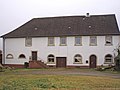
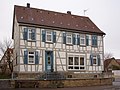
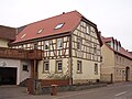
- The Siegelbach Castle goes to the original Hirschhorner yard back and was extended by the Count of Wiser in the early 18th century to a castle. After the Wiser had sold the castle in 1833 and a subsequent owner had built a brewery in an older cellar, the property briefly served as the Zum Badischer Hof inn from 1841 . The facility came into the possession of the Protestant community in 1862, which has since used the castle building as a rectory and since 1960 also as a kindergarten. The former brewery building was temporarily used as a fat factory, then used for agriculture and is now a residential building.
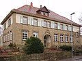
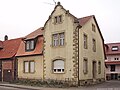
- The town's schoolhouse, which was built in the former castle garden, was built in 1912/1913 from regional sandstone. The town hall and gymnasium are modern functional buildings made of precast concrete and were inaugurated in 1971 and have been modernized on various occasions since then. The town's war memorial was erected in 1969.

Siegelsbach Castle
Former Farm building / brewery
school

town hall


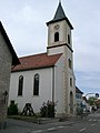
- The Catholic Church of St. George goes back to the original church of the village, which was reformed in the 16th century and added to the Catholics in 1710 under the Count of Wiser. The old building fell into disrepair after 1800 and was demolished in 1857, the following year the current building was built. The interior was restored in 1927, but the church was stripped of its historical furnishings and decoration in the course of the liturgical reform in 1956 and is now characterized by simple, modern furnishings.
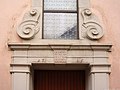
- The Evangelical Church was built in a simple baroque style from 1765 after the old church in the town was banned for Protestant worship in 1711 and the Protestant worship was held temporarily in the town hall. The portal of the church is crowned by Rollwerk. The church was consecrated on March 29, 1767. A part of the construction costs had been collected in Northern Germany and Holland by a Siegelbach buckle maker, Georg Friedrich Riemer († 1781). The builder was Johann Melchior Weylbacher from Bonfeld. The first bell was donated in 1769. In 1820 a church organ was procured from the organ builder brothers Overmann from Heidelberg. The church was renovated several times in 1854, 1889 and 1981/82 and received two new bells in 1922 and 1951, after the two largest bells had been melted down in the previous world wars.
- Next to the Protestant church is the historic Protestant schoolhouse , which was the second town hall from 1935 to 1971 and can be recognized by the municipality's coat of arms on the facade. After the historic town hall, which was also in the center of the town and which already existed in 1711, became dilapidated, the former Protestant school building was converted into a town hall. The Protestant school was established in 1805. In 1877 the denominational schools were merged into a single school. After the construction of the new school house in 1913, the former Protestant school was initially empty, then the school hall was the practice room of the gymnastics club until 1934, later the SA assembly room. In 1935 the building was converted into the town hall, after which the old town hall was demolished. The building was the town hall until the opening of today's (third) town hall, which was newly built in 1971, and has served as a residential building ever since.
- The former Catholic school at the Catholic Church was recently renovated, whereby the timber frame of the building was exposed again. Today the building is also a residential building.
Catholic Church
Ev. Church, portal

Former Protestant schoolhouse, second town hall
Former cath. school


- There are some historic half-timbered houses in the village, especially from the early 19th century, including the renovated property in Hauptstraße 19 with a residential building from 1810 and a double barn from 1834, which has now been converted into residential buildings, and in Hauptstraße 73 as well as the unrenovated property at Lindengasse 18 (around 1810) and Lettengasse 9 (before 1820). There are also several historic stables and barns. Most of the historic residential buildings face the street on the gable side because of the small size of the property, behind which the barns are mostly standing across.

Lettengasse 9
Main street 73

Lindengasse 18


- Some representative buildings from the early 20th century were built from regional sandstone, including the station management from 1902 and the neighboring building that was built in the same year. The building of the Hotel Alte Post in Hauptstrasse 68, built in 1897 in the historicist style, was once the residential and office building of the Grötzinger brothers, the owners of the oil and fat goods factory.
- The Siegelsbacher Bahnhof was originally a small two-story building on a narrow rectangular floor plan. The building with gable gables on the eaves side facing Bahnhofstrasse and the platform had a stone base, the upper floor was constructed in half-timbered construction and clad with wood. Due to numerous conversions and additions, the original design of the building, which has now been used as a restaurant, can hardly be recognized.
- The Schnepfenhardter Mühle is the historic Bannmühle located on the Neckar in the Fünfmühlental . The property burned down in June 1957 and was rebuilt as an excursion restaurant.

Railway station restaurant
Residential building Bahnhofstrasse

Former railway station

Schnepfenhardter Mill


Economy and Infrastructure

The most important company in Siegelsbach is Mann & Schröder GmbH , which produces cosmetic articles with over 700 employees. The company goes back to a soap factory founded by Jacob Grötzinger in the farm buildings of the castle in 1864. In 1951, Hans Schröder and his partners founded Mann & Schröder KG , which initially produced window putty, later also shoe polish, washing-up liquid and other products. From 1959 the product range was switched to cosmetic and personal care products, which are sold worldwide under various trademarks.
traffic
The Siegelsbach station is a station of the Krebsbachtalbahn from Hüffenhardt to Neckarbischofsheim Nord . Regular passenger traffic was discontinued on August 1, 2009. On Sundays and public holidays from June to October there are excursions with Uerdingen rail buses . The community is located near the federal motorway 6 , junction Bad Rappenau.
media
The daily newspaper Kraichgau Stimm (a subsidiary edition of Heilbronner Voice ) and the Rhein-Neckar-Zeitung reported on the events in Siegelsbach .
education
In Siegelbach is the Astrid Lindgren - primary school . There is also a Protestant and a Catholic kindergarten . In addition, the Unterland Adult Education Center in Siegelsbach has a branch.
Personalities
- Franz Bernhard (1934–2013), sculptor, lived temporarily in Siegelsbach after 1946
- RA The Rugged Man (* 1974), New York rapper, spent a lot of time with relatives in Siegelsbach in his childhood and early youth
literature
- Rudolf Petzold: Siegelsbach - A home book . Siegelsbach community, Siegelsbach 1986
Individual evidence
- ↑ State Statistical Office Baden-Württemberg - Population by nationality and gender on December 31, 2018 (CSV file) ( help on this ).
-
^ Source for the section on community structure:
Das Land Baden-Württemberg. Official description by district and municipality. Volume IV: Stuttgart district, Franconian and East Württemberg regional associations. Kohlhammer, Stuttgart 1980, ISBN 3-17-005708-1 . P. 59 - ↑ State Statistical Office, area since 1988 according to actual use for Siegelsbach.
- ↑ USAAF 320th Bomb Group, February 25, 1945: aerial photo ; Bomb ploot ; Final report (en.) (PDF; 852 kB)
- ↑ http://www.stimme.de/kraichgau/nachrichten/artikel/Haucap-neuer-Buergermeister-in-Siegelsbach;art140019,3929769
- ↑ Heinz Bardua: The district and community coats of arms in the Stuttgart administrative region . Theiss, Stuttgart 1987, ISBN 3-8062-0801-8 (district and municipality coat of arms in Baden-Württemberg, 1). P. 126
- ↑ VHS Unterland branch offices .
- ↑ Interview video with RA the rugged man, in which he mentions his connection with Siegelsbach ( memento of the original from October 20, 2013 in the Internet Archive ) Info: The archive link was inserted automatically and has not yet been checked. Please check the original and archive link according to the instructions and then remove this notice.
Web links
- Link catalog on Siegelsbach at curlie.org (formerly DMOZ )

Abstatt | Bad Friedrichshall | Bad Rappenau | Bad Wimpfen | Beilstein | Brackenheim | Cleebronn | Eberstadt | Ellhofen | Eppingen | Erlenbach | Flein | Gemmingen | Güglingen | Gundelsheim | Hardthausen am Kocher | Ilsfeld | Ittlingen | Jagsthausen | Kirchardt | Langenbrettach | Lauffen am Neckar | Lehrensteinsfeld | Leingarten | Lion's Arch | Massenbachhausen | Möckmühl | Neckarsulm | Neckarwestheim | Neudenau | Neuenstadt am Kocher | Nordheim | Obersulm | Oedheim | Offenau | Pfaffenhofen | Roigheim | Schwaigern | Siegelbach | Talheim | Untereisesheim | Untergruppenbach | Weinsberg | Rams | Desert red | Zaberfeld