
Fünfmühlental

The Fünfmühlental near Bad Rappenau in Baden-Württemberg is the valley of the Mühlbach , a left tributary to the Neckar , in which five historic mills are located.
geography

The Mühlbach rises near Babstadt and flows east to Bad Rappenau, where the Raubach flows towards it from the left and where it feeds the moat of the Bad Rappenau moated castle . On the short stretch to Zimmerhof , the brook then turns quickly to the north, before its village border the Dobach , which comes from the forest lake in the west-northwest, flows to it from the left . After the village, below the Zimmerhofer Gutshof, a more natural valley section begins, which is usually referred to as the Fünfmühlental alone. First of all, the stream passes the ball mill in the triangle of the mouth of the Tiefenbach , which also comes from the west-northwest, which is dammed shortly before its confluence with the Römersee , and the Fischersee . Immediately after a sewage treatment plant , the Siegelsbach flows towards it from the northwest , before the Mühlbach enters a narrowing valley with forest slopes on both sides, partly down to the bank; 75 hectares of the forest were elevated to Bannwald in 1970 . Due to the gradient and further tributaries, the Mühlbach gains flow speed and volume in this valley section. The Barthsmühle , the Sommersmühle and the Schnepfenhardter Mühle are located here one after the other . They do not border on the banks of the brook themselves, rather branched mill ditches led to them the water. In the lower reaches of the Schnepfenhardter Mühle, the stream turns for about 1 km to the northeast and then takes its previous northern direction again at the foot of the mountain spur in the east, on which Guttenberg Castle stands. He leaves his forest valley below the castle and with the old town center of Neckarmühlbach on the right at the Maysack mill . This is where the Fünfmühlental ends, after a few hundred meters the Mühlbach itself flows into the river Neckar, which is quite wide here.
The stream is almost twelve kilometers long. It begins its course in the soft patch of Babstadt at just under 245 m and flows into the Neckar at just over 140 m , so the total difference in altitude is a little under 105 meters. Its catchment area extends to about 29 km², it is mainly to the left, since from the middle reaches the Neckar, which flows roughly parallel to the north on the right, less than 3 km away. Initially, the Mühlbach runs in a straightened bed, in the urban area of Bad Rappenau it is even mostly twisted, then behind Zimmerhof and up to Neckarmühlbach in natural meanders . The brook is said to have been rich in fish and crabs from the mouth up to around the Barthsmühle until the 20th century .
The mills in the Fünfmühlental

Originally there were six water mills on the Mühlbach , of which only five are left today. The four oldest mills are located on the lower reaches and in the narrow and steep valley of the Mühlbach, where there was enough water power even in dry years due to the inflow of side streams. The ball mill above the forest valley was built as the fifth mill in 1690. The sixth mill, the Rappenau mill , stood further up the stream, roughly where the Bad Rappenau spa gardens are located today. There the Mühlbach was probably dammed by a weir. This mill, built around 1710, was already in disrepair in 1790 and was demolished.
The mills were driven by wooden wheels, the water was fed to them with weirs and through mill ditches . They mostly ground grain and had one or two grinding cycles and a tanning cycle for pitting the spelled . In the late Middle Ages, the mills belonged to the respective landlords, who introduced the ban on mills and compulsory meals. Around 1800 the mills became the property of the millers, who occasionally became prosperous and held public offices. There were miller dynasties whose members sat on mills for generations, in the Fünfmühlental, among others, the Nischinger, Sommer and Barth families.
In the period before and after the First World War, the water wheels of the mills were replaced by turbines and their technology was generally modernized, but their operation became increasingly uneconomical. The Barthsmühle stopped grinding as early as 1920, three more mills were shut down around 1960, and the Maysack mill was the last in the valley to run until 1980.
In the following, the mills still existing today are described in the downward direction.
Ball mill

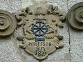
The ball mill ▼ north of Zimmerhof was built by Samuel Hess around 1690. The property, first named Kugelmühle in 1717, takes its name from the associated Kugelwiese . In the 18th century it was a ban mill for the town of Babstadt further south-west. The water for the mill operation was taken from both the Mühlbach and the Tiefenbach, which was dammed a little west of the mill to the Römersee; Parts of the mill ditches have been preserved to this day. The current building was rebuilt in 1784. Among the millers of the ball mill were two mayors of Zimmerhof: Johann Jacob Meyding († 1850) and Wilhelm Friedrich (1875–1951). Milling in the ball mill ended in 1958, later the descendants of the last miller set up a bar in the mill.

Portal stone of the ball mill, dated 1784

Envy of the ball mill

Rest of the mill ditch coming from the Tiefenbach


Barthsmühle

The Barthsmühle (Obere Mühle) ▼ was mentioned as Haberkornmühle as early as 1596 . It was owned by the von Ehrenbergs, passed to the von Helmstatt family in 1658 and later privately owned by the Baron von Schade. The mill also had a concession for the southwestern towns of Treschklingen and Babstadt. The name Barthsmühle comes from the miller family Barth, who owned the mill from 1811 to 1878 and installed a second grinder. The last miller family stopped milling around 1920. In 1921 the property came into the possession of the then Zimmerhof municipality, and in 1936 it was sold to private individuals as a residential building.
Summer mill

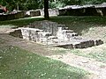
The summer mill (middle mill) ▼ was also owned by Ehrenberg and has existed at least since the 16th century. The mill was the only one of the mills in the valley to have two grinding cycles , later a tanning machine, a hemp grater and a sawmill were added. The mill takes its name from the Sommer tenant family, who owned the mill from 1787 to around 1910 and who rebuilt the building, which was renovated in 1736, in 1825. Mill operations ended at the beginning of the 1960s. The property burned down in 1995, underwent a major renovation in 2001 and is now a residential building. There has been a game reserve around the summer mill since 1978.

The ruins after the fire in 1995 from the north

... and from the south


Schnepfenhardter Mill

The Schnepfenhardter Mühle ▼ was mentioned for the first time in 1358 and at that time already belonged to Siegelsbach , initially still owned by the landlords, since 1544 owned by the community. From the 17th the mill is also referred to as the basic mill . A cellar building was built in 1785 and the mill building was rebuilt in 1859. In 1861 a hemp grater was added. From the 1930s, the mill had mainly customers among the sailors from Haßmersheim , which could grind the flour supplies for their long journey here. In 1957 the facility was partially destroyed by fire, whereupon the owner family returned the concession and gradually converted the property into the Mühlenschenke inn .
Maysack mill

The Maysacksche Mühle ▼ is located shortly before the confluence of the Mühlbach in the Neckar in Neckarmühlbach and has been documented as the castle mill of Guttenberg Castle since 1357 . The mill was the ban mill of the respective castle lords. The mill has had its current appearance since the 18th century. The name goes back to Johannes Maysack (1763-1840), who was the last existing miller in service until 1808. In 1808 it was sold to the Baden state, which carried out brine drilling here until 1820 in vain . On February 28, 1820, Johannes Maysack bought the mill for his son Bernhard, which was badly damaged by the Neckar flood in 1824. A high water mark on the nearby former Gasthaus Schiff is evidence of this flood . The Maysack family continued the mill business for five generations and did not stop until 1980. The mill was occasionally open for inspection on mill days. At Mühlentag 2007, the local researcher and last miller, Ludwig Maysack (1911–2008), gave a personal introduction to their history.
Portal of the Maysack mill

Neidkopf at the Maysackschen mill

Mill ditch of the Maysack mill

Milling chair of the Maysack mill


Further sights on the Mühlbach and its tributaries

In Bad Rappenau, the Mühlbach feeds both the moat from the Bad Rappenau moated castle and the lake in the spa park, which was completely redesigned for the 2008 State Garden Show. The Dobach , which flows into the Mühlbach east of Bad Rappenau, first passes the Maierhof , the former residence of the Zimmerhof administrators. To the north of it flows the Tiefenbach , on which lies the Kohlhof, founded in 1709, and a Roman villa rustica near the dammed Römersee . The large Heinsheim Jewish cemetery , which has existed since the 16th century, is located on the southern slope of the gorge of the Schlierbach , which flows further down the valley from the northeast . A little before the estuary, Guttenberg Castle, documented since 1232, rises on the mountain spur between the Mühlbach and Neckar valleys.

Bad Rappenau moated castle
Villa rustica by the Römersee

Game reserve at the summer mill

Heinsheim Jewish cemetery


See also
literature
- Rudolf Petzold: The Mühlbach and its mills . In: Bad Rappenauer Heimatbote , No. 12, March 2001
- Ludwig Maysack: The Mühlbachtal and its 5 mills - A hike through a gem of our homeland (2000)
Individual evidence
- ↑ Geographical information according to the topographic map 1: 25,000 Baden-Württemberg (north)