
Neckarmuehlbach
|
Neckarmuehlbach
Local community Haßmersheim
|
|
|---|---|
 |
|
| Height : | 158 m |
| Residents : | 516 (June 30, 2017) |
| Incorporation : | February 1, 1972 |
| Postal code : | 74855 |
| Area code : | 06266 |
Neckarmühlbach is a village in the Neckar-Odenwald district in Baden-Württemberg , which has been part of Haßmersheim since 1972 . Neckarmühlbach is a Baden wine town and cultivates the Trollinger and Lemberger varieties in the Hohberg hillside location, terraced by dry stone walls, directly above the Neckar.
geography
Neckarmühlbach is located between Heilbronn and Mosbach am Mühlbach , which flows into the Neckar from the left less than 300 meters north of the town .
history


The place was first mentioned in 856 as "Muhlenbach". The Altort is a castle hamlet on a slope and is located on the access road up to Guttenberg Castle, first mentioned in 1232 . He was originally named as the brook Mühlbach , was later to better distinguish same from other towns name in Neckarmühlbach renamed. The stream of the same name in the so-called Fünfmühlental , which today largely belongs to the city of Bad Rappenau , drove a number of mills . A predecessor building of the Maysackschen mill at the foot of the Burgsporn is proven in 1357 as a castle mill. The residents of the village provided farmers and day laborers in the service of the rulers at Guttenberg Castle. In the 13th century these were the lords of Weinsberg , from the 15th century the lords of Gemmingen . The place was reformed in the first half of the 16th century under Dietrich von Gemmingen († 1526) .
During the Thirty Years' War , Swedish troops plundered Neckarmühlbach as well as other places in the Neckar valley in order to force the surrender of Heidelberg. The lower-lying properties of the place were affected by floods several times, the biggest flood was in 1824. In 1854 there were 269 inhabitants and 25 residential buildings in the place. In 1879 a new school and town hall was built. When the lower Neckar was canalized by 1935, the Gundelsheim barrage was built and, for the first time, a bridge connection over the Neckar to Gundelsheim .
On February 1, 1972 Neckarmühlbach was incorporated into Haßmersheim.
In 1939 there were 210 inhabitants, then 392 at the end of 1945. After the Second World War, over 150 displaced persons moved in and several new building areas were designated. In 2005 the population was 532.
coat of arms
The coat of arms of Neckarmühlbach shows a blue sloping bar in gold. Blue and yellow are the colors of the former local rule, the Lords of Gemmingen .
Attractions


- The Burg Guttenberg , established since 1232, is inhabited continuously from the barons of Gemmingen-Guttenberg since the 15th century. The complex is now a popular excursion destination, there is a gryphon station and a knight museum.
- The Evangelical Church, which is also the castle chapel of Guttenberg Castle, which Pleikard von Gemmingen had built around 1471, stands on the site of the Eucharist Chapel, founded in 1393 by the Archbishop of Mainz, Konrad II von Weinsberg , below the castle. In, on and around the chapel there are numerous historical epitaphs for members of the von Gemmingen family as well as a burial place of this family with graves from the 19th and 20th centuries.
- The Maysacksche mill is occupied since the 14th century as belonging to Burg Guttenberg mill. Between 1820 and 1980 the business was privately run by five generations of the Maysack family. The mill is one of the five mills in the Fünfmühlental .
- At the mill is the old stables from 1807, a stately stables building which today houses a hay hotel and a restaurant. Opposite is the former Gasthaus Schiff, a half-timbered building from 1783, which today houses the sawmill administration.
- The old town hall was built in 1879 as a school and town hall instead of a previous building. Next to it is a baroque rectory with the coat of arms of the Lords of Gemmingen .

Old stables
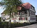
Former Gasthaus Schiff

Old town hall from 1879

Rectory


Web links
Individual evidence
- ^ Community website Haßmersheim
- ^ Federal Statistical Office (ed.): Historical municipality directory for the Federal Republic of Germany. Name, border and key number changes in municipalities, counties and administrative districts from May 27, 1970 to December 31, 1982 . W. Kohlhammer, Stuttgart / Mainz 1983, ISBN 3-17-003263-1 , p. 477 .
- ↑ Communications from the Württ. And Bad. State Statistical Office No. 2: Results of the population census on December 31, 1945 in North Baden