
Ittlingen
| coat of arms | Germany map | |
|---|---|---|

|
Coordinates: 49 ° 12 ' N , 8 ° 56' E |
|
| Basic data | ||
| State : | Baden-Württemberg | |
| Administrative region : | Stuttgart | |
| County : | Heilbronn | |
| Height : | 188 m above sea level NHN | |
| Area : | 14.11 km 2 | |
| Residents: | 2571 (Dec. 31, 2018) | |
| Population density : | 182 inhabitants per km 2 | |
| Postal code : | 74930 | |
| Area code : | 07266 | |
| License plate : | HN | |
| Community key : | 08 1 25 047 | |
| LOCODE : | DE ITG | |
| Address of the municipal administration: |
Hauptstrasse 101 74930 Ittlingen |
|
| Website : | ||
| Mayor : | Kai Kohlenberger | |
| Location of the municipality of Ittlingen in the district of Heilbronn | ||
  |
||

Ittlingen is a municipality in Kraichgau in the Heilbronn district of Baden-Württemberg . It belongs to the Heilbronn-Franken region and the outskirts of the Stuttgart metropolitan region .
geography
Geographical location
Ittlingen is located in the northwest of the Heilbronn district in the upper Elsenz valley , about 6 km north-northeast of Eppingen and about 8 km south-southeast of Sinsheim . The major cities of Mannheim , Heidelberg , Heilbronn and Karlsruhe with their metropolitan areas are less than 50 km as the crow flies .
The Elsenz runs through the municipality from south to north. Apart from smaller bodies of water, it flows in the upstream local area of the Sulzbach or Sulzbachgraben from Weiler in the northwest, and a little below the village, the Bockschafter Bach, which previously crossed the village of Bockschaft , flows out of the Ittlinger Tal valley . Towards the western edge of the municipality's area, it has around 2 km² of the Bannholz , otherwise there are only small forest islands in it. On the undulating hills of the Kraichgau, agriculture dominates the open fields, which is favored by the loess sediment cover over a large part of the area.
Neighboring communities
Neighboring cities and communities are ( clockwise , starting in the west): Sinsheim ( Rhein-Neckar-Kreis ), Kirchardt and Eppingen . Kirchardt and Eppingen belong to the Heilbronn district. With Eppingen and the municipality of Gemmingen , Ittlingen has become the Eppingen-Gemmingen-Ittlingen administrative community .
Community structure
Apart from the eponymous village, Ittlingen does not include any other districts or places in the official sense. However, there are three settlement sites with their own names in satellite locations, the Forlenhöfe group of Aussiedlerhof farms in the west-southwest, the individual Friedenshorst estate downstream on the Elsenz and the Hammberger Hof in the lowest Ittlinger valley .
Division of space

According to data from the State Statistical Office , as of 2014.
history
Until the 19th century
Ittlingen was first mentioned as Uchlinheim in a document dated to the year 773 in the Lorsch Codex . During the time of the tribal duchies, the place was in the Duchy of Franconia . In the 12th century there was a local nobility (Lords of Ucklingen), but almost nothing is known about them today. In the 13th and 14th centuries, the Counts of Öttingen had rights in Ittlingen. In 1414 Dietrich von Gemmingen received half of Ittlingen as a fief, and he bought the other half. The lords of Gemmingen (lines to Gemmingen and to Michelfeld) owned Ittlingen half as an allod property, half as a fiefdom of the Counts of Öttingen. After the extinction of the Gemmingen-Michelfeld, the Grecken von Kochendorf appeared as co-local lords from 1616 , after their extinction in 1749 the Gemmingen-Hornberg. Ittlingen came to Baden in 1806 .
20th and 21st centuries
In 1939 there were 1,152 inhabitants, at the end of 1945 there were 1,409.
After the Second World War, the once agricultural town changed into a workers' residential community, for which several new building areas were developed. Individual businesses also settled here. Before the district reform in Baden-Württemberg in 1973, Ittlingen belonged to the Sinsheim district , but then came to the Heilbronn district . In 1987 an extensive renovation program began for the town center, with which the area around the church and the community center in particular was upgraded. The renovation program was officially completed in July 2006.
Religions
In Ittlingen there is a Protestant, a Catholic, a free church and a New Apostolic church congregation. The majority of the Ittlingen population is Protestant.

The Jewish community of Ittlingen has been recorded since the 17th century, as the Lords of Gemmingen and the Grecken after the Thirty Years' War increasingly took in Jews in the place where previously only individual Jews had lived. In 1722 five Jewish families are named, the number of which increased to 15 by 1795. A synagogue had existed since 1686 at the latest and was replaced by a new synagogue in Mühlgasse in 1805. Around 1850, the Jewish community had its highest membership level with just under 180 people, which, however, would decline sharply in the following years due to emigration and emigration. The Jewish cemetery in Ittlingen had existed since 1887 . In 1933 the Jewish community still numbered 37 people, more than half of whom emigrated to the USA by 1938. The synagogue in Mühlgasse was devastated during the November pogroms in 1938 , then demolished and the site has been used as a garden ever since. Of the last eight Ittlingen Jews who were deported to Camp de Gurs in October 1940 , only one survivor is known. Since 1988 a memorial plaque has been commemorating the former synagogue.
politics

Municipal council
Ittlingen's municipal council has 12 seats. The municipal council election on May 25, 2014 led to the following result:
- List of free voters : share of votes 66.6% (- 1.0) → 8 seats (-)
- Women in the municipal council : 33.4% of the votes (+ 1.0) → 4 seats (-)
Another member of the council and its chairman is the mayor.
mayor
- 1985–2017: Achim Heck
- since 2017: Kai Kohlenberger
In June 2017, Kai Kohlenberger was elected as the new mayor of Ittlingen after Achim Heck did not stand again after 32 years.
badges and flags
The blazon of the Ittlinger coat of arms reads: In blue two golden bars, covered with a red heart shield, inside a fallen golden ploughshare. The flag of the municipality is yellow-blue.
The Ittlinger coat of arms proposed by the General State Archives in Karlsruhe in 1910 shows the blue-gold colors of the Lords of Gemmingen , the local owners from 1355 to 1806. The heart shield with the ploughshare referring to agriculture is used to distinguish it from the Gemmingen coat of arms . The flag, which is derived from the colors of the coat of arms, was awarded to Ittlingen on October 1, 1980 by the district office of Heilbronn.
Attractions

- The Evangelical Church in the northeast of the town center was built in 1732 and expanded to its present form in 1828. It goes back to a choir tower church built as a fortified church from the 13th century. An inscription stone above the western side portal reminds of the new building from 1732. The church was renovated in 1988. With her is the community center .
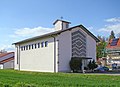
- The Catholic Church of St. Michael and the New Apostolic Church of the town are simple buildings from the second half of the 20th century.

Evangelical Church, west portal
Catholic Church

New Apostolic Church


- The Castle Ittlingen on Bauberg southwest of the town center is the core of the mansion of among the lords of Gemmingen built in 1577 building yard back. The vault of the cellar door on the north side of the building is dated with the year of construction, and above it is an ornate coat of arms stone. The portal on the west facade of the building has additional architectural decorations. The castle, used for residential purposes, is surrounded by historic farm buildings.

Manor house, portal
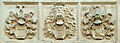
Manor house, Wappenstein


- In addition to today's town hall at the northeast end of the town center, which was built as a schoolhouse in the style of a hunting lodge with two round towers on the sides of the main facade and converted into town hall in 1976, the old town hall from the early 19th century according to plans by the town center is still there Architects Weis from Karlsruhe received.
- There are various war memorials near the town hall, in the cemetery and at the southern end of the main street.
- The Ittlingen Jewish Cemetery on Bergstrasse was laid out in 1887.
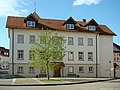
- A large number of historical buildings have been preserved in the center of the village, including numerous half-timbered houses and historical farm buildings with partly listed galleries.
Community center
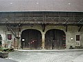
Barn from 1854

War memorial


Economy and Infrastructure

Ittlingen is a rural community with a few small and medium-sized businesses. In the east of the municipality, shell limestone is mined in a large quarry , which is mainly used for building material mixtures.
traffic
About 4 km from Ittlingen is the Sinsheim-Steinsfurt motorway junction of federal motorway 6 .
The Ittlingen stop is on the Steinsfurt – Eppingen railway line, which opened in 1900 and has been electrified since 2009 . The route is served every hour by line S 5 of the RheinNeckar S-Bahn . The Ittlingen station building is privately owned.
media
The daily newspaper Kraichgau Stimm, a subsidiary edition of Heilbronner Voice, reports on the events in Ittlingen .
Sons and daughters of the church
- Kurt Wimpfheimer (1915–2013), German-American professor and author
Individual evidence
- ↑ State Statistical Office Baden-Württemberg - Population by nationality and gender on December 31, 2018 (CSV file) ( help on this ).
- ^ The state of Baden-Württemberg. Official description by district and municipality. Volume IV: Stuttgart district, Franconian and East Württemberg regional associations. Kohlhammer, Stuttgart 1980, ISBN 3-17-005708-1 . Pp. 78-79
- ↑ State Statistical Office, area since 1988 according to actual use for Ittlingen.
- ↑ Minst, Karl Josef [transl.]: Lorscher Codex (Volume 4), Certificate 2640, November 773 - Reg. 989. In: Heidelberg historical stocks - digital. Heidelberg University Library, p. 192 , accessed on April 7, 2016 .
- ↑ Communications from the Württ. And Bad. State Statistical Office No. 2: Results of the population census on December 31, 1945 in North Baden
- ↑ http://www.stimme.de/kraichgau/nachrichten/artikel/Kohlenberger-neuer-Buergermeister;art140019,3869383
- ↑ Heinz Bardua: The district and community coats of arms in the Stuttgart administrative region . Theiss, Stuttgart 1987, ISBN 3-8062-0801-8 (district and municipality coat of arms in Baden-Württemberg, 1). P. 82
- ↑ Heike Kinkopf: Ittlingen - intact structures in the midst of lush greens . In: Heilbronner Voice from August 10, 2006
literature
- Karl Engelhardt : A Baden farming village 50 years ago and now. Population and economic life . Buchdruckerei Carl Pfeffer, Heidelberg 1910. (Inaugural dissertation of the Friedrich-Wilhelms-Universität Berlin ; 70 pages; the village of Ittlingen is dealt with around 1860 and around 1910)
Web links

Abstatt | Bad Friedrichshall | Bad Rappenau | Bad Wimpfen | Beilstein | Brackenheim | Cleebronn | Eberstadt | Ellhofen | Eppingen | Erlenbach | Flein | Gemmingen | Güglingen | Gundelsheim | Hardthausen am Kocher | Ilsfeld | Ittlingen | Jagsthausen | Kirchardt | Langenbrettach | Lauffen am Neckar | Lehrensteinsfeld | Leingarten | Lion's Arch | Massenbachhausen | Möckmühl | Neckarsulm | Neckarwestheim | Neudenau | Neuenstadt am Kocher | Nordheim | Obersulm | Oedheim | Offenau | Pfaffenhofen | Roigheim | Schwaigern | Siegelbach | Talheim | Untereisesheim | Untergruppenbach | Weinsberg | Rams | Desert red | Zaberfeld