
Hardthausen am Kocher
| coat of arms | Germany map | |
|---|---|---|

|
Coordinates: 49 ° 15 ' N , 9 ° 24' E |
|
| Basic data | ||
| State : | Baden-Württemberg | |
| Administrative region : | Stuttgart | |
| County : | Heilbronn | |
| Height : | 182 m above sea level NHN | |
| Area : | 35.55 km 2 | |
| Residents: | 4159 (Dec. 31, 2018) | |
| Population density : | 117 inhabitants per km 2 | |
| Postcodes : | 74239, 74249 | |
| Primaries : | 07139, 06298 | |
| License plate : | HN | |
| Community key : | 08 1 25 111 | |
| LOCODE : | DE HHK | |
| Community structure: | 3 districts | |
| Address of the municipal administration: |
Lampoldshauser Strasse 8 74239 Hardthausen am Kocher |
|
| Website : | ||
| Mayor : | Thomas simplicity | |
| Location of the municipality of Hardthausen am Kocher in the Heilbronn district | ||
  |
||

Hardthausen am Kocher is a rural residential community in the Heilbronn district in Baden-Württemberg , which consists of the districts of Gochsen , Kochersteinsfeld and Lampoldshausen . It belongs to the Heilbronn-Franken region .
geography
Geographical location
Hardthausen is located in the east of the Heilbronn district in the lower Kochertal on the southern edge of the Harthäuser Forest .
Neighboring communities
Neighboring cities and communities in Hardthausen are (clockwise, starting in the south): Langenbrettach , Neuenstadt am Kocher , Neudenau , Möckmühl , Widdern , Jagsthausen (all districts of Heilbronn), Forchtenberg and Öhringen (both Hohenlohe districts ). With Langenbrettach and Neuenstadt am Kocher, Hardthausen has entered into an agreed administrative community , the seat of the administrative community is the city of Neuenstadt am Kocher.
Community structure
Hardthausen consists of the districts of Gochsen , Kochersteinsfeld and Lampoldshausen . The Haaghof farm and the Buchsmühle and Sonnenhof residential areas belong to Gochsen and the Buchhof and Schweizerhof farms to Kochersteinsfeld. Places that have passed and no longer exist today are on the Gochsen Treuchtlingen mark, Hertrichshausen and Katzbronn on the Kochersteinsfeld mark, and Bistenweiler, Dreßweiler, Hertwigshausen and Tegerenbach on the Lampoldshausen mark.
Division of space

According to data from the State Statistical Office , as of 2014.
history
Early history
The districts of Gochsen and Kochersteinsfeld were listed in a certificate from Emperor Otto III. first mentioned on December 18, 996 . In 1939 there were 759 inhabitants in Gochsen, at the end of 1945 there were 861. During the same period, the population in Kochersteinsfeld grew from 682 to 785 and in Lampoldshausen from 706 to 751.
20th century
On January 1, 1974, Gochsen and Kochersteinsfeld volunteered to form the new municipality of Hardthausen am Kocher. On January 1, 1975, the municipality of Lampoldshausen was added by the Municipal Reform Act (also as part of an association), which sued the law but lost on October 23, 1975 at the Baden-Württemberg State Court.
All suburbs were dominated by agriculture, while from the 1920s only little industry settled, so that Hardthausen is now predominantly a residential community for commuters from the surrounding cities and communities. Due to the designation of extensive new development areas, the suburbs have grown significantly beyond their original settlement areas. Around 15 hectares of land have been newly developed since 1998, with more to follow.
Religions
Gochsen, Kochersteinsfeld and Lampoldshausen each have their own Protestant parishes. There are congregations in Neuenstadt am Kocher for Catholics, New Apostolic Christians and Jehovah's Witnesses.
politics
Municipal council
The local council in Hardthausen has 16 members. The local elections on May 25, 2014 led to the following official final result. The municipal council consists of the elected voluntary councilors and the mayor as chairman. The mayor is entitled to vote in the municipal council.
| Parties and constituencies |
% 2014 |
Seats 2014 |
% 2009 |
Seats 2009 |
||
| FWV | Free electoral association | 61.2 | 10 | 59.6 | 10 | |
| CDU | Christian Democratic Union of Germany | 38.8 | 6th | 40.4 | 6th | |
| total | 100.0 | 10 | 100.0 | 10 | ||
| voter turnout | 59.85% | 63.9% | ||||
mayor
In the election on June 17, 2018, the then 29-year-old Thomas Einfalt was elected the new mayor of the community with 56.8 percent of the votes cast. On August 24 of the same year, he took over the official duties from his predecessor Harry Brunnet, who previously held the office for five terms and was thus temporarily the longest-serving mayor of Baden-Württemberg.
badges and flags
The blazon of the coat of arms of Hardthausen am Kocher reads: In silver, a blue, sloping, wavy bar, covered with three diagonally upwardly directed heart-shaped golden leaves and accompanied on each side by a diagonally downwardly directed black stag pole. The flag of the municipality is blue and white.
The coat of arms, newly created after the emergence of Hardthausen in the municipal reform, combines elements of the coats of arms of the three predecessor municipalities. The sloping wave bar symbolizes the cooker , the three leaves are derived from the coat of arms of the Lords of Gochsen, but can also be related to Hardt (pasture forest) as part of the name. The Württemberg stag sticks remind of the fact that all three parts of the community belong to Württemberg . The coat of arms and the flag were awarded to the community on June 14, 1977 by the district office of Heilbronn.

Gochsen's coat of arms

Coat of arms of Kochersteinsfeld

Lampoldshausen's coat of arms


Attractions


There are historic churches and town halls in each of the three sub-towns. The Protestant church in Kochersteinsfeld , mostly built in 1733, contains various historical epitaphs, including several by Herzögl. Württ. Forestry masters, as well as two war memorials for the local fallen of both world wars. The neighboring rectory was built in 1789. The church in Lampoldshausen was given its current appearance through renovation in 1749 and has much older wall paintings. There is also a historic rectory near the church in Lampoldshausen.
The former town halls of Gochsen and Lampoldshausen are still used as administrative offices, the town hall in Kochersteinsfeld, built in 1808, became the town hall of Hardthausen.
The Buchsbachtal is a humid biotope between Gochsen and Kochersteinsfeld that was created by straightening the Kocher in the delta between the oxbow lake and the Kochersteinsfeld, which is a natural monument.

Gochsen Church
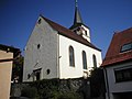
Kochersteinsfeld Church

Lampoldshausen Church


Gochsen town hall and school building
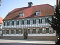
Town hall Kochersteinsfeld

Lampoldshausen town hall


Economy and Infrastructure
In the vicinity of the Lampoldshausen district, there has been a large DLR test facility area for static burn tests of rocket engines, especially for Ariane rockets , since 1963 . Astrium Space Transportation is also located on the site . a. Develops, builds and tests attitude control engines for satellites.
Viticulture
The Hardt Hausen district Kochersteinsfeld is a wine-growing whose layers to Großlage Kochersberg in the range Kocher-Jagst Tauber of Weinbaugebietes Württemberg belong.

traffic
Hardthausen is located directly on the federal highway 81 . The next connection points are in Neuenstadt am Kocher and in Möckmühl. The previous connection to the Untere Kochertalbahn ( Bad Friedrichshall - Ohrnberg ) has been inactive since 1993.
media
The daily newspaper Heilbronner Voice reports on the events in Hardthausen in its issue N, District North.
education
There is a primary school each in Gochsen, Kochersteinsfeld and Lampoldshausen . In addition, the Unterland Adult Education Center in Hardthausen has a branch.
Sports
The Buchsmühle sports center is located in the Gochsen district . In addition to the new sports hall in Buchsbachtalhalle , there are two soccer fields and a tennis court.
literature
-
Hardthausen in history (s) in Hardthausen . Hardthausen parish, Hardthausen am Kocher 1997
Historical outline of the parish.
Web links
Individual evidence
- ↑ State Statistical Office Baden-Württemberg - Population by nationality and gender on December 31, 2018 (CSV file) ( help on this ).
- ^ Source for the section on community structure: Das Land Baden-Württemberg. Official description by district and municipality. Volume IV: Stuttgart district, Franconian and East Württemberg regional associations. Kohlhammer, Stuttgart 1980, ISBN 3-17-005708-1 . Pp. 127-129
- ↑ State Statistical Office, area since 1988 according to actual use for Hardthausen am Kocher.
- ↑ Communications from the Württ. And Bad. State Statistical Office No. 1: Results of the population census on December 31, 1945 in Northern Württemberg
- ^ Federal Statistical Office (ed.): Historical municipality directory for the Federal Republic of Germany. Name, border and key number changes in municipalities, counties and administrative districts from May 27, 1970 to December 31, 1982 . W. Kohlhammer, Stuttgart / Mainz 1983, ISBN 3-17-003263-1 , p. 465 .
- ↑ Hardthausen has a new mayor. In: Stimme.de. June 17, 2018, accessed August 27, 2018 .
-
↑ Source for the section coat of arms and flag:
Heinz Bardua: The district and community coat of arms in the Stuttgart administrative region . Theiss, Stuttgart 1987, ISBN 3-8062-0801-8 (district and municipality coat of arms in Baden-Württemberg, 1). P. 74 - ↑ VHS Unterland branch offices .

Abstatt | Bad Friedrichshall | Bad Rappenau | Bad Wimpfen | Beilstein | Brackenheim | Cleebronn | Eberstadt | Ellhofen | Eppingen | Erlenbach | Flein | Gemmingen | Güglingen | Gundelsheim | Hardthausen am Kocher | Ilsfeld | Ittlingen | Jagsthausen | Kirchardt | Langenbrettach | Lauffen am Neckar | Lehrensteinsfeld | Leingarten | Lion's Arch | Massenbachhausen | Möckmühl | Neckarsulm | Neckarwestheim | Neudenau | Neuenstadt am Kocher | Nordheim | Obersulm | Oedheim | Offenau | Pfaffenhofen | Roigheim | Schwaigern | Siegelbach | Talheim | Untereisesheim | Untergruppenbach | Weinsberg | Rams | Desert red | Zaberfeld