Oxen
|
Oxen
Municipality Hardthausen am Kocher
|
|
|---|---|
| Coordinates: 49 ° 14 '28 " N , 9 ° 21' 45" O | |
| Height : | 182 m |
| Area : | 8.54 km² |
| Residents : | 1708 (2009) |
| Population density : | 200 inhabitants / km² |
| Incorporation : | 1st January 1974 |
Gochsen is a district of Hardthausen am Kocher in the Heilbronn district in northern Baden-Württemberg .
geography
Gochsen is located in the east of the Heilbronn district in the lower Kochertal on the southern edge of the Harthäuser Forest . The A 81 runs west of the village on its section from Heilbronn to Würzburg.
The Haaghof farm and the Buchsmühle and Sonnenhof residential areas belong to Gochsen . Treuchtlingen is a lost place on Markung Gochsen that no longer exists today.
history
Gochsen was first mentioned in a certificate from Emperor Otto III. mentioned on December 18, 996. The place essentially shares the history of Kochersteinsfeld , which is also part of Hardthausen am Kocher today ; like this Gochsen belonged to the Lords of Dürn in the high Middle Ages , later to the Lords of Weinsberg and in the 15th century the Electoral Palatinate , before the place came to Württemberg in 1504 . With the Lords of Gosheim , beginning with the Udalricus de Cosheim mentioned in 1075, a local nobility is proven in Gochsen, which, however, already expired by the 16th century. In the 14th and 15th centuries, the Schöntal monastery and the lords of Gemmingen also owned the site. The Buchsmühle residential area was first mentioned in 1843 and was uninhabited in 1961.
In 1939 there were 759 inhabitants in Gochsen, at the end of 1945 there were 861. In 1961 the Haaghof residential area was developed. On January 1, 1974, Gochsen and Kochersteinsfeld volunteered to form the new municipality of Hardthausen am Kocher. On January 1, 1975, the municipality of Lampoldshausen was added by the municipal reform law.
From 1913 to 1993 the Lower Kocher Valley Railway operated Bad Friedrichshall - Ohrnberg as a private railway of the Württemberg Railway Company (WEG) Gochsen. The tracks were dismantled in early 2006. A cycle path on the route was officially opened in spring 2009 as part of the Kocher-Jagst cycle path .
Religions
Gochsen was originally parish in Kochersteinsfeld . A separate parish was established in 1315. Due to its affiliation with Württemberg, Gochsen was reformed in the 16th century. There is a separate Evangelical Church Community. There are congregations in Neuenstadt am Kocher for Catholics, New Apostolic Christians and Jehovah's Witnesses.
coat of arms
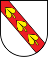
The blazon of the former coat of arms of Gochsen reads: In silver, a red sloping bar, covered with three heart-shaped golden water lily leaves ("sea leaves") .
Attractions
- In the town center, the town hall and the church form a striking historical ensemble at the eastern end of the historical town center. The town hall was also the town's schoolhouse and was built in 1889. Later a pyramid-shaped war memorial was erected in front of the town hall. The tower of the historic Protestant church bears building inscriptions from the 17th century, and its west facade also reveals the gable and arch of an older nave . There is still an old linden tree near the church .
- The Buchsbachtal is a humid biotope between Gochsen and Kochersteinsfeld that was created by straightening the Kocher in the delta between the oxbow lake and the Kochersteinsfeld, which is a natural monument.
Sports
The Buchsmühle sports center is located in Gochsen . In addition to the new sports hall in Buchsbachtalhalle , there are two soccer fields and a tennis court.
Personalities
- Wilhelm Vogt (1854–1938), farmer and politician (member of the Landtag and Reichstag)
- Karl Vogt (1883–1952), son of Wilhelm Vogt, farmer and politician, Member of the Bundestag (CDU)
Individual evidence
- ↑ Source for the places belonging to Gochsen: Das Land Baden-Württemberg. Official description by district and municipality. Volume IV: Stuttgart district, Franconian and East Württemberg regional associations. Kohlhammer, Stuttgart 1980, ISBN 3-17-005708-1 . Pp. 127-129
- ↑ https://www.leo-bw.de/web/guest/detail-gis/-/Detail/details/ORT/labw_ortslexikon/2324/Buchsmühle+-+Wohnplatz
- ↑ Communications from the Württ. And Bad. State Statistical Office No. 1: Results of the population census on December 31, 1945 in Northern Württemberg
- ↑ https://www.leo-bw.de/web/guest/detail-gis/-/Detail/details/ORT/labw_ortslexikon/2328/Haaghof+-+Wohnplatz
- ^ Federal Statistical Office (ed.): Historical municipality directory for the Federal Republic of Germany. Name, border and key number changes in municipalities, counties and administrative districts from May 27, 1970 to December 31, 1982 . W. Kohlhammer, Stuttgart / Mainz 1983, ISBN 3-17-003263-1 , p. 465 .
- ↑ Wolfgang Müller: Old bridge in ruins . In: Heilbronner Voice of August 21, 2008 . ( at Stimme.de ).
literature
- Wilhelm Aichele: The Kocher Valley. Aichele, Schwäbisch Gmünd 1956, pp. 174/75


