
Pfaffenhofen (Württemberg)
| coat of arms | Germany map | |
|---|---|---|

|
Coordinates: 49 ° 4 ′ N , 8 ° 59 ′ E |
|
| Basic data | ||
| State : | Baden-Württemberg | |
| Administrative region : | Stuttgart | |
| County : | Heilbronn | |
| Local government association: | Upper Zabergäu | |
| Height : | 206 m above sea level NHN | |
| Area : | 12.04 km 2 | |
| Residents: | 2424 (December 31, 2018) | |
| Population density : | 201 inhabitants per km 2 | |
| Postal code : | 74397 | |
| Area code : | 07046 | |
| License plate : | HN | |
| Community key : | 08 1 25 081 | |
| Community structure: | 2 districts | |
| Address of the municipal administration: |
Rodbachstrasse 15 74397 Pfaffenhofen |
|
| Website : | ||
| Mayor : | Dieter Boehringer | |
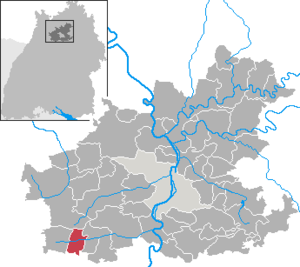
| Location of the municipality of Pfaffenhofen in the Heilbronn district | ||
  |
||

Pfaffenhofen is a municipality in the district of Heilbronn , Baden-Württemberg . It belongs to the Heilbronn-Franken region and the outer metropolitan region of Stuttgart .
geography

Geographical location
Pfaffenhofen is located on the Zaber in the Zabergäu in the southwestern district of Heilbronn.
Neighboring communities
Neighboring cities and communities in Pfaffenhofen are ( clockwise , starting in the west): Zaberfeld , Eppingen , Güglingen (all districts of Heilbronn) and Sachsenheim ( districts of Ludwigsburg ). Together with Güglingen and Zaberfeld, Pfaffenhofen forms the municipal administration association “Oberes Zabergäu” based in Güglingen.
Community structure
In addition to the main town, the hamlet of Weiler an der Zaber belongs to Pfaffenhofen . The hamlet Rodbachhof and the residential area Bogersmühle also belong to Pfaffenhofen . The lost, so no longer existing place Rodenbach was on the mark Pfaffenhofen, in its place is today's hamlet Rodbachhof.
Division of space

According to data from the State Statistical Office , as of 2014.
history
Early history
Pfaffenhofen was probably founded at the time of the Christianization of Germany. It is mentioned for the first time in a document on May 30, 1279 as Pfaffenhoven . Burkhard von Hohenberg sold half of the village to Württemberg before 1380 , and the other half followed in 1380. The hamlet of Rodbachhof was first mentioned in 1709; the Bogersmühle residential area was developed in 1835.
Weiler an der Zaber probably already existed around the year 1000. On June 15, 1279 it was first mentioned in a document. In the 14th century the place became part of Württemberg. Probably between 1460 and 1470 during the reign of Count Eberhard im Bart, the village of Pfaffenhofen was fortified by building a village wall with moats, towers and gates, possibly to protect the wine stored in the village.
Incorporations
On January 1, 1972, Weiler an der Zaber was incorporated into Pfaffenhofen.
Religions
Pfaffenhofen originally belonged to the Speyer diocese . The introduction of the Reformation in Württemberg made it Protestant . Even today the place is predominantly evangelical, so there is a separate evangelical parish each in Pfaffenhofen and Weiler. The Catholic parish Hl. Dreifaltigkeit Güglingen is responsible for the Catholic Christians .
Population development
- 1939: 968 inhabitants
- 1945: 1071 inhabitants
- 1961: 1640 inhabitants
- 1970: 1838 inhabitants
- 1980: 1914 inhabitants
- 1990: 2223 inhabitants
- 1995: 2364 inhabitants
- 2000: 2342 inhabitants
- 2005: 2349 inhabitants
- 2010: 2396 inhabitants
- 2015: 2335 inhabitants
politics

Municipal council
In Pfaffenhofen, the municipal council is elected using the spurious selection of a part of town. The number of local councils can change due to overhang mandates . After the last election in May 2014, the municipal council in Pfaffenhofen has twelve members (2009: 12). The turnout was 53.86%. The municipal council consists of the elected voluntary councilors and the mayor as chairman. The mayor is entitled to vote in the municipal council.
| Free Citizens (FB) | 6 seats | 52.83% | (2009: not known) |
| Free Voter Association (FWV) | 6 seats | 47.17% | (2009: not known) |
mayor
In October 2013 Dieter Böhringer (* 1954) was re-elected for a fifth term. He has been in office since 1982.
coat of arms
The blazon of the Pfaffenhofen coat of arms reads: In silver, a flesh-colored priest tonsure with a black wreath of hair. The flag of the municipality is red and white.
The oldest known seal of Pfaffenhofen, which can be traced from 1482 to 1611, shows a human figure behind a fence: a talking coat of arms , a priest (priest) in a courtyard. Colored representations of this coat of arms have been handed down from 1535. A stain seal from 1678 showed two erect lions holding a disc.
From 1583 onwards, drawings of coats of arms showed the priest tonsure, a new, also speaking coat of arms. Pfaffenhofen’s stain mark , which was handed down in 1684, is also a simplified tonsure, which perhaps also forms the basis of the disc in the seal from 1678.
In the 20th century at the latest, misunderstandings turned the tonsure into a sun with a face. It was not until 1956 that the parish again accepted the priest tonsure as a coat of arms at the suggestion of the Baden-Württemberg archives department. The coat of arms was confirmed by the Ministry of the Interior on November 13, 1956, the flag was awarded to the municipality on January 31, 1980 by the district office of Heilbronn.
Culture and sights
region
Pfaffenhofen is on the Württemberger Weinstrasse , which leads past many sights.

Buildings
- The Lambertus Church is a Protestant parish church. It goes back to a Gothic building with a choir tower around 1300, was expanded several times and received its present shape mainly through a renovation in 1610/12.
- The parsonage belonging to it was built in 1610, as was the church extension by Heinrich Schickhardt . The walling of the parish garden goes back to parts of the village wall of the 15th century, which was demolished except for a few remains in 1817.
- The fountain on the Kelterplatz and a nearby wall fountain were designed by the Güglingen sculptor Gunther Stilling .
- In the town center, numerous half-timbered buildings from the 16th and 17th centuries have been preserved along the main street.

Ascent to the gallery of the Lambertus Church

Evang. Rectory

Hauptstrasse 21, built in 1508

Hauptstrasse 25, built in 1563


Natural monuments
South of the village, on the ridge of the Stromberg, lies the White Quarry , an important site of fossils from the Keuper, with a viewing platform in front.
Economy and Infrastructure
Larger companies based in Pfaffenhofen are Pretec ( gear manufacturing) with over 100 employees and Lang-Verpackungen with around 80 employees.

traffic
The B 27 is reached in Lauffen am Neckar and Kirchheim am Neckar . Local public transport in the H3NV transport association is guaranteed by buses. There is also a connection to the rail network in Lauffen and Kirchheim ( Frankenbahn ).
In 1901 the Zabergäubahn (Lauffen am Neckar-Leonbronn) reached Pfaffenhofen and Weiler. The Royal Württemberg State Railways built the Pfaffenhofen station building as a type IIa unit station . The line was closed in 1986 for passenger traffic and 1995 for freight traffic. Drafted plans to reactivate them as part of the Heilbronn light rail network by 2011 have not been pursued since 2006 due to a lack of financial resources.
media
The daily newspaper Heilbronner Voice reports on the events in Pfaffenhofen in its issue W, Landkreis West.
education
Pfaffenhofen has a primary school .
Personalities
Honorary citizen
- Gerhard Aßfahl (1904–2007), educator and local researcher
Born in Pfaffenhofen
- Fritz Klein (1908–1966), SA standard leader
Individual evidence
.jpg)
- ↑ State Statistical Office Baden-Württemberg - Population by nationality and gender on December 31, 2018 (CSV file) ( help on this ).
-
^ Source for the section on community structure:
Das Land Baden-Württemberg. Official description by district and municipality. Volume IV: Stuttgart district, Franconian and East Württemberg regional associations. Kohlhammer, Stuttgart 1980, ISBN 3-17-005708-1 . Pp. 84-85 - ↑ State Statistical Office, area since 1988 according to actual use for Pfaffenhofen.
- ↑ Rodbachhof - living space - detail page - LEO-BW. Retrieved June 11, 2020 .
- ↑ Bogersmühle - living space - detail page - LEO-BW. Retrieved June 11, 2020 .
- ↑ Who will save the remains of the village wall? - STIMME.de. Retrieved June 11, 2020 .
- ^ Federal Statistical Office (ed.): Historical municipality directory for the Federal Republic of Germany. Name, border and key number changes in municipalities, counties and administrative districts from May 27, 1970 to December 31, 1982 . W. Kohlhammer, Stuttgart / Mainz 1983, ISBN 3-17-003263-1 , p. 451 .
- ↑ http://www.stimme.de/regioticker/Buergermeister-Boehringer-wird-60;art16233,3195954
-
^ Sources for the section coat of arms and flag:
Heinz Bardua: The district and community coat of arms in the Stuttgart administrative region . Theiss, Stuttgart 1987, ISBN 3-8062-0801-8 (district and municipality coat of arms in Baden-Württemberg, 1). P. 114
Eberhard Gönner: Book of arms of the city and district of Heilbronn with a territorial history of this area . Archive Directorate Stuttgart, Stuttgart 1965 (Publications of the State Archive Administration Baden-Württemberg, 9). P. 131f. - ↑ Employees at lang-verpackungen.de (accessed on April 21, 2016)
- ^ Rainer Stein: The Württemberg standard station on branch lines . In: Eisenbahn-Journal Württemberg-Report . tape 1 , no. V / 96 . Merker, Fürstenfeldbruck 1996, ISBN 3-922404-96-0 , p. 80-83 .
- ↑ Thomas Dorn: The tram to Zabergäu is currently not payable . In: Heilbronner Voice of July 11, 2006, p. 30.
Web links

Abstatt | Bad Friedrichshall | Bad Rappenau | Bad Wimpfen | Beilstein | Brackenheim | Cleebronn | Eberstadt | Ellhofen | Eppingen | Erlenbach | Flein | Gemmingen | Güglingen | Gundelsheim | Hardthausen am Kocher | Ilsfeld | Ittlingen | Jagsthausen | Kirchardt | Langenbrettach | Lauffen am Neckar | Lehrensteinsfeld | Leingarten | Lion's Arch | Massenbachhausen | Möckmühl | Neckarsulm | Neckarwestheim | Neudenau | Neuenstadt am Kocher | Nordheim | Obersulm | Oedheim | Offenau | Pfaffenhofen | Roigheim | Schwaigern | Siegelbach | Talheim | Untereisesheim | Untergruppenbach | Weinsberg | Rams | Desert red | Zaberfeld