
Kirchzell
| coat of arms | Germany map | |
|---|---|---|

|
Coordinates: 49 ° 37 ' N , 9 ° 11' E |
|
| Basic data | ||
| State : | Bavaria | |
| Administrative region : | Lower Franconia | |
| County : | Miltenberg | |
| Height : | 192 m above sea level NHN | |
| Area : | 63.86 km 2 | |
| Residents: | 2211 (Dec. 31, 2019) | |
| Population density : | 35 inhabitants per km 2 | |
| Postal code : | 63931 | |
| Area code : | 09373 | |
| License plate : | MIL, OBB | |
| Community key : | 09 6 76 131 | |
| Market structure: | 9 districts | |
Market administration address : |
Hauptstrasse 19 63931 Kirchzell |
|
| Website : | ||
| Mayor : | Stefan Schwab ( CSU ) | |
| Location of the Kirchzell market in the Miltenberg district | ||
  |
||

Kirchzell is a market in the Lower Franconian district of Miltenberg . The place in the Odenwald lies in the triangle of Bavaria , Hesse and Baden-Württemberg .
geography
Geographical location
Kirchzell is the largest municipality in terms of area in the Miltenberg district and manages 1,300 hectares of forest. The municipality is located in the Bergstrasse-Odenwald Geo-Nature Park . The red sandstone area is drained from Waldbach, Gabelbach and Mud to the Main . The topographically highest point of the municipality is at 548 m above sea level. NN (location) at the summit of the mountain The Kolli at the border triangle, the lowest is on the Mud at 170 m above sea level. NN (location) .
Cities in the vicinity are:
Community structure
Kirchzell has nine districts in four districts (the type of settlement in brackets):
|
|
Neighboring communities
Neighboring communities are:
Surname
etymology
The name Kirchzell consists of the Middle High German words kirche and cëlle , in the sense of farmyard. The church in the name refers to the church there, which is confirmed by the spelling of 1534 Kirch zu Zell .
Earlier spellings
Earlier spellings of the place from various historical maps and documents:
|
|
history
Until the church is planted
Kirchzell is a community with 1200 years of history. Kirchzell owes its foundation to the Benedictine abbey in Amorbach. In 1168 the Amorbach monastery and with it Kirchzell came under the rule of the Lords of Dürn . This dynasty built Wildenberg Castle (also Wildenburg) on the Preunschener Berg , which was a masterpiece of castle construction in the Staufer era . 100 years later, the noblemen of Dürn sold their lands to the Archbishop of Mainz. In 1700 Kirchzell was granted market rights as the central parish of the "Kirchzeller Grund" . The Mainz office was assigned to the Prince of Leiningen in the Reichsdeputationshauptschluss (1803) , mediated by Baden in 1806 and ceded to Hessen-Darmstadt in 1810 . In the Hessen / Bavaria recession (Frankfurt 1816) it finally fell to Bavaria . In the course of the administrative reforms in Bavaria, today's municipality was created with the municipal edict of 1818 .
Administrative history
In 1862 the Miltenberg district office was formed, on whose administrative area Kirchzell was located. As everywhere in the German Reich , the term district was introduced in 1939. Kirchzell was now one of the 31 parishes in the old district of Miltenberg . On July 1, 1972, this merged with the district of Obernburg am Main to form the new district of Miltenberg .
Incorporations
On January 1, 1975, the previously independent communities Ottorfszell, Preunschen (community name until 1870 Preunschen-Buch ) and Watterbach were incorporated into the Kirchzell market. They included the districts of Breitenbuch and Buch and the hamlets of Dörnbach, Breitenbach, Schrahmühle and Hofmühle.
politics
Market council
The municipal council consists of 14 members who, after the local elections on March 15, 2020, will be divided as follows for the 2020–2026 election period:
mayor
Mayor is Stefan Schwab from the CSU. He was again confirmed in office in the 2020 local elections without a competitor with 86.4% of the valid votes.
coat of arms
Blazon : "In red a small silver church with a roof turret and column portal on the front, both with a black cross attached, accompanied in front by a left-facing, golden bishop's staff head , behind by a six-spoke, silver wheel."
Declaration of coat of arms: The church functions as a talking coat of arms symbol , the bishop's staff and the Mainz wheel indicate that it belongs to Kurmainz and the Amorbach monastery .
economy
Kirchzell has the following transport connections:
- approx. 45 km to the A 81 motorway junction
- approx. 50 km to the A 3 motorway junction
- approx. 51 km to the ICE in Aschaffenburg
- approx. 6 km to the regional train in Amorbach
- approx. 89 km to Frankfurt / Main Airport
Education and culture
Museums
- Forest museum in the "Watterbacher Haus" in the Preunschen district. The Watterbacher Haus is a so-called stable house and is one of the oldest farmhouses in the Odenwald. The “ridge house” was built around 1475. It was originally in Watterbach. In 1982 it was moved to Preunschen. In the forest museum, the forest-historical development of the Odenwald, the forest use of earlier times, basket making and cone picking are presented.
Buildings
- Remains of the Limes, once a protective wall of the Romans against the Teutons
- High medieval castle ruins Wildenberg (also Wildenburg) from the Staufer period, on which Wolfram von Eschenbach is said to have written parts of his Parzival .
- Oldest wayside shrine in the Odenwald in Breitenbuch from 1483, further historical wayside shrines in the other districts
- Watterbacher Haus - the oldest half-timbered house in the Odenwald
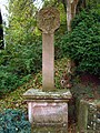
Wayside shrine in Watterbach
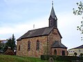
Church in Breitenbuch
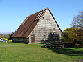
Watterbacher House in Preunschen
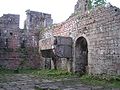
Wildenberg Castle, Palaswand with chimney

Ottorfszell Church


Hiking trails
The Nibelungensteig , a 130-kilometer long long- distance hiking trail certified with the quality seal "Quality Trail Wanderable Germany", leads through the districts of Breitenbach, Ottorfszell and Preunschen .
music
Kirchzell has had a choral society since 1891, which now consists of four choirs.
- Male choir (since 1891)
- Women's choir (since 1999)
- VoCapella (since 2002)
- Piccolino (since 2005)
- Choir 4 You
Male and female choirs as well as VoCapella are under the direction of Hermann Trunk. Piccolino and Chor 4 You are directed by Birgit Wagner.
Sports
The handball club TV Kirchzell , founded in 1908, plays in the third division in the 2016/17 season . The Kickers Kirchzell football club was founded in 1922.
Oddities
Kirchzell
In Kirchzell, too, beans were grown in the middle of the 19th century . In the dialect, the elongated pod that surrounds it was called “Schludde”, meaning the whole fruit was called “Schluddebohne”. The strange word creation was of course the reason for the nickname for the neighboring towns - Ortsnecknames .
Ottorfszell
Ravens and crows are the birds with the greatest intelligence , scientists have found in a study. This is also confirmed by the neighboring communities by giving the inhabitants of the Gabelbachtal the local name “Talkrabbe”.
Watterbach
The people of Watterbach received the nickname "Gräbbeleshüpfer" from their neighbors because they dug irrigation ditches through agricultural land in order to achieve a reasonable yield on the high-lying area.
literature
- Ernst Rockstroh: thunderstorm over Kirchzell
- Thomas Ratzka: 300 years of market rights in Kirchzell
- Pleikard Joseph Stumpf : Kirchzell . In: Bavaria: a geographical-statistical-historical handbook of the kingdom; for the Bavarian people . Second part. Munich 1853, p. 798 ( digitized version ).
Web links
- Homepage of the Kirchzell community
- Entry on the coat of arms of Kirchzell in the database of the House of Bavarian History
- Kirchzell: Official statistics of the LfStat
- Kichzell in the location database of the Bayerische Landesbibliothek Online . Bavarian State Library
Individual evidence
- ↑ "Data 2" sheet, Statistical Report A1200C 202041 Population of the municipalities, districts and administrative districts 1st quarter 2020 (population based on the 2011 census) ( help ).
- ↑ http://www.bayerische-landesbibliothek-online.de/orte/ortssuche_action.html ? Anzeige=voll&modus=automat&tempus=+20111123/184317&attr=OBJ&val= 1692
- ↑ a b Wolf-Armin von Reitzenstein : Lexicon of Franconian place names. Origin and meaning . Upper Franconia, Middle Franconia, Lower Franconia. CH Beck, Munich 2009, ISBN 978-3-406-59131-0 , p. 118 ( limited preview in Google Book search).
- ^ Wilhelm Volkert (ed.): Handbook of Bavarian offices, communities and courts 1799–1980 . CH Beck, Munich 1983, ISBN 3-406-09669-7 , p. 523 .
- ^ Federal Statistical Office (ed.): Historical municipality directory for the Federal Republic of Germany. Name, border and key number changes in municipalities, counties and administrative districts from May 27, 1970 to December 31, 1982 . W. Kohlhammer GmbH, Stuttgart / Mainz 1983, ISBN 3-17-003263-1 , p. 750 .
- ↑ Local council election 2020 Markt Kirchzell, overall result , accessed on June 14, 2020
- ↑ Werner Trost Stampes, Worzelköpp and Staffelbrunzer Lkr.Miltenberg 2003
- ↑ S. o.
- ↑ S. o.
Kirchzell | Ottorfszell with Breitenbach | Preunschen with book | Watterbach with Breitenbuch , Dörnbach and Schrahmühle

Altenbuch | Amorbach | Bürgstadt | Collenberg | Dorfprozelten | Eichenbühl | Elsenfeld | Erlenbach am Main | Eschau | Faulbach | Großheubach | Großwallstadt | Hausen | Kirchzell | Kleinheubach | Kleinwallstadt | Klingenberg am Main | Laudenbach | Leidersbach | Miltenberg | Mömlingen | Mönchberg | Neunkirchen | Niedernberg | Obernburg am Main | Röllbach | Rüdenau | Schneeberg | Stadtprozelten | Sulzbach am Main | Weilbach | Wörth a.Main
Unregulated areas: forest forest | High maintenance