
Schneeberg (Lower Franconia)
| coat of arms | Germany map | |
|---|---|---|

|
Coordinates: 49 ° 38 ' N , 9 ° 15' E |
|
| Basic data | ||
| State : | Bavaria | |
| Administrative region : | Lower Franconia | |
| County : | Miltenberg | |
| Height : | 168 m above sea level NHN | |
| Area : | 16.61 km 2 | |
| Residents: | 1769 (Dec. 31, 2019) | |
| Population density : | 107 inhabitants per km 2 | |
| Postal code : | 63936 | |
| Area code : | 09373 | |
| License plate : | MIL, OBB | |
| Community key : | 09 6 76 156 | |
| Market structure: | 3 districts | |
Market administration address : |
Amorbacher Str. 1 63936 Schneeberg |
|
| Website : | ||
| Mayor : | Kurt Repp ( CSU ) | |
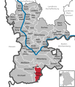
| Location of the Schneeberg market in the Miltenberg district | ||
  |
||

Schneeberg is a market in the Miltenberg district in Lower Franconia .
geography
Geographical location
Schneeberg is located in the Odenwald in the Bavarian Lower Main region . The topographically highest point of the municipality is at 471 m above sea level. NN (location) on the summit of the winter mountain south of Hambrunn, the lowest is on the Billbach at 158 m above sea level. NN (location) .
Community structure
The municipality has three districts (the type of settlement in brackets):
- Hambrunn ( Kirchdorf )
- Schneeberg (market)
- Zittenfelden (Kirchdorf)
There are the districts of Hambrunn, Schneeberg and Zittenfelden.
Schneeberg has an exclave in the forest southeast of Reichartshausen, which is itself an exclave of the city of Amorbach .
history
Until the church is planted
At the time of the first clearing and the settlement of the Marsbach , Morre and Muththales in the eighth or ninth century, Schneeberg was still called Sneiteberc. The first written mention of Schneeberg was in 1237, which documented the ownership structure at that time.
Schneeberg belonged to the Grand Duchy of Hesse-Darmstadt . The town has belonged to Bavaria since the Munich Treaty of 1816 . The Mainz town was assigned to the princes of Leiningen in the Reichsdeputationshauptschluss 1803 , mediatized by Baden in 1806 and ceded to Hessen-Darmstadt in 1810. In the Hessen / Bavaria recession (Frankfurt 1816) it finally fell to Bavaria . In the course of the administrative reforms in Bavaria, today's municipality was created with the municipal edict of 1818 .
Administrative history
In 1862 the Miltenberg District Office was formed, on whose administrative area Schneeberg was located. As everywhere in the German Reich , the term district was introduced in 1939. Schneeberg was now one of the 31 communities in the old district of Miltenberg . On July 1, 1972, this merged with the district of Obernburg am Main to form the new district of Miltenberg .
Surname
etymology
The name Schneeberg consists of the Middle High German words sneite and bërc . The word sneite means something like “path cut through the forest” or “passage” (aisle). The first clearing took place in the area of a deeply cut valley between the steeply rising mountain heights of the Odenwald.
Earlier spellings
Earlier spellings of the place from various historical maps and documents:
|
|
Incorporations
On January 1, 1975, the previously independent municipality of Hambrunn and the dissolved municipality of Beuchen, which was called Beuchen-Zittenfelden until 1870, incorporated the municipality of Zittenfelden, while Beuchen was assigned to the city of Amorbach .
Population development
- 1961: 1466 inhabitants
- 1970: 1754 inhabitants
- 1987: 1822 inhabitants
- 1991: 1987 inhabitants
- 1995: 1968 inhabitants
- 2000: 1904 inhabitants
- 2004: 1902 inhabitants
- 2005: 1897 inhabitants
- 2006: 1865 inhabitants
- 2007: 1834 inhabitants
- 2008: 1845 inhabitants
- 2009: 1829 inhabitants
- 2010: 1798 inhabitants
- 2011: 1788 inhabitants
- 2012: 1803 inhabitants
- 2013: 1783 inhabitants
- 2014: 1801 inhabitants
- 2015: 1785 inhabitants
- 2016: 1798 inhabitants
On January 1, 2006, the Schneeberg market identified second residences in 2009, of which 1931 were people with German citizenship . The people came from 17 nations.
politics
mayor
Kurt Repp ( CSU ) has been mayor since March 2020 . He was elected with 88.94%.
Erich Kuhn (CSU) was mayor of the market town from 1996 to 2020, his predecessor in office was Artur Trunk.
Municipal council
After the 2020 election, the municipal council will consist of twelve people:
Architectural monuments
Economy and Infrastructure
Economy including agriculture and forestry
In 2017 there were 324 jobs subject to social security contributions in the municipality. Of the resident population, 776 people were in employment subject to compulsory insurance. This means that the number of out-commuters was 452 more than that of in-commuters. 25 residents were unemployed. In 2016 there were 9 farms.
traffic
The federal highway 47 , the Nibelungenstraße , leads through Amorbach on the way from Michelstadt in the west to Walldürn in the east.
The stop at Schneeberg im Odenwald is on the Seckach – Miltenberg (KBS 784), also known as the Madonnenlandbahn . In Seckach there is a connection to the Rhein-Neckar S-Bahn , which is integrated into the Rhein-Neckar transport association (VRN). The station is also part of the transitional tariff area of the Rhein-Main transport association .
The public transport is the transport association at the Bavarian Lower Main operated.
Long-distance cycle routes
The following cycle paths lead through the village :
- The 225 km long 3-country cycle route leads as a circular route through the triangle of Hesse, Baden-Württemberg and Bavaria. The route explores the Odenwald along the Mümling, Neckar and Main rivers.
- The German Limes Cycle Route leads from Bad Hönningen through Westerwald , Taunus and Odenwald to Regensburg, 818 kilometers away, and is based on the historical course of the Upper German-Raetian Limes .
Hiking trails
The Nibelungensteig , a 130-kilometer long long- distance hiking trail certified with the quality seal “Quality Trail Wanderable Germany”, runs close to the Zittenfelden district, directly at the Zittenfeldener Quelle . The west loop of the 794 km long Franconian Marienweg also leads past the pilgrimage church of Mary's Birth in Schneeberg.
education
There are the following institutions (as of 2018):
- A day-care center for children with 90 places and 86 children
Personalities
- Alfred Pfaff (born July 16, 1926 in Frankfurt-Rödelheim ; † December 27, 2008 in Erlenbach am Main ) was a German soccer player and soccer world champion from 1954 . From 1961 until his death in 2008 he lived as a hotelier in the Zittenfelden district
- Bodo Kuhn (born August 9, 1967 in Miltenberg ) took part in the 1988 Summer Olympics in Seoul . He won the bronze medal in the men's 4 x 400 meter relay (in the heats at the start, not used in the final run).
- Artur Trunk (* May 17, 1932 - May 8, 2013), honorary citizen and former mayor. D. von Schneeberg
Web links
- Official website of the market
- Entry on the coat of arms of Schneeberg (Lower Franconia) in the database of the House of Bavarian History
Individual evidence
- ↑ "Data 2" sheet, Statistical Report A1200C 202041 Population of the municipalities, districts and administrative districts 1st quarter 2020 (population based on the 2011 census) ( help ).
- ↑ http://www.bayerische-landesbibliothek-online.de/orte/ortssuche_action.html ? Anzeige=voll&modus=automat&tempus=+20111123/202322&attr=OBJ&val= 1706
- ↑ a b Wolf-Armin von Reitzenstein : Lexicon of Franconian place names. Origin and meaning . Upper Franconia, Middle Franconia, Lower Franconia. CH Beck, Munich 2009, ISBN 978-3-406-59131-0 , p. 200 ( limited preview in Google Book Search).
- ↑ Page no longer available , search in web archives: Schneeberg and why it's called that . In: Primavera24.de , December 18, 2010. Accessed December 19, 2010.
- ^ Wilhelm Volkert (ed.): Handbook of Bavarian offices, communities and courts 1799–1980 . CH Beck, Munich 1983, ISBN 3-406-09669-7 , p. 523 .
- ↑ a b c Federal Statistical Office (ed.): Historical municipality directory for the Federal Republic of Germany. Name, border and key number changes for municipalities, counties and administrative districts from May 27, 1970 to December 31, 1982 . W. Kohlhammer GmbH, Stuttgart / Mainz 1983, ISBN 3-17-003263-1 , p. 750 .
- ↑ https://www.wahlen-in-mil.de/wahlverbindungen/kommunalwahlen_2020/09676156/html5/Buergermeisterwahl_Bayern_73_Gemeinde_Markt_Schneeberg.html
- ↑ https://www.vdk.de/ov-schneeberg/ID136929
- ↑ http://www.buergerinfo-schneeberg.de/to0050.php?__ktonr=1732

Altenbuch | Amorbach | Bürgstadt | Collenberg | Dorfprozelten | Eichenbühl | Elsenfeld | Erlenbach am Main | Eschau | Faulbach | Großheubach | Großwallstadt | Hausen | Kirchzell | Kleinheubach | Kleinwallstadt | Klingenberg am Main | Laudenbach | Leidersbach | Miltenberg | Mömlingen | Mönchberg | Neunkirchen | Niedernberg | Obernburg am Main | Röllbach | Rüdenau | Schneeberg | Stadtprozelten | Sulzbach am Main | Weilbach | Wörth a.Main
Unregulated areas: forest forest | High maintenance