
Woerth am Main
| coat of arms | Germany map | |
|---|---|---|

|
Coordinates: 49 ° 48 ' N , 9 ° 9' E |
|
| Basic data | ||
| State : | Bavaria | |
| Administrative region : | Lower Franconia | |
| County : | Miltenberg | |
| Height : | 126 m above sea level NHN | |
| Area : | 15.89 km 2 | |
| Residents: | 4706 (Dec. 31, 2019) | |
| Population density : | 296 inhabitants per km 2 | |
| Postal code : | 63939 | |
| Area code : | 09372 | |
| License plate : | MIL, OBB | |
| Community key : | 09 6 76 169 | |
| LOCODE : | DE WUR | |
| City structure: | 1 district | |
City administration address : |
Luxburgstrasse 10 63939 Wörth a.Main |
|
| Website : | ||
| Mayor : | Andreas Fath (Free Voters) | |
| Location of the city of Wörth am Main in the Miltenberg district | ||
  |
||

Wörth am Main (officially: Wörth a.Main ) is a town in the Miltenberg district in Lower Franconia . It is located in northwest Bavaria south of Aschaffenburg .
geography
Geographical location
Wörth is located in the Main Valley , nestled between the hills of Odenwald and Spessart . The city is located in the area of the Mainviereck on the left bank of the Main, directly opposite the city of Erlenbach am Main . Other neighboring communities are in the north Obernburg am Main and in the south Klingenberg am Main and in the west the Hessian Odenwald community Lützelbach ( district Seckmauern ).
The area of the district of 15.89 km² is divided into forest (9.20 km²), agricultural area (4.50 km²), settlement and traffic area (1.80 km²) and water area (0.29 km²). The trees in the urban forest contain a relatively high proportion of pine trees such as pines (44%), larches (8%), spruces (6%) and Douglas firs (4%). The deciduous trees contain around 28% beech , 7% oak , and 2% hardwood and other deciduous trees.
The topographically highest point of the city mark is at 398 m above sea level. NN on the northern slope of the Schabelsberg, southwest of Wörth, the lowest is in the Main at 116.5 m above sea level. NN .
geology
Geologically, Wörth am Main belongs to the south-west German stepland . About 240 to 250 million years ago ( Triassic ) the area of today's Lower Franconia was only a few degrees of latitude north of the equator . The area was located in a shallow, partially flooded basin in which sand and clays were deposited, which were transported from the surrounding mountains by powerful rivers. Over the course of millions of years, the red sandstone typical of this area was formed from this . The rather arid climate of the time led to overall hostile conditions, so that there are only a few fossils in the red sandstone. In the course of the following millions of years, mighty layers of shell limestone and keuper formed over the red sandstone.
Lower Franconia only became mainland in the Middle Jurassic (around 170 million years ago). In connection with the unfolding of the Alps in the Tertiary (until about 40 million years ago), the layers of the earth were tilted. The red sandstone was raised and the overlying layers largely removed by erosion . The surface of today's landscape was formed during the last ice age by solifluction (soil flow), frost (frost debris cover ), flooding and washing away of rivers and streams and loess swellings .
climate

The climate is warm and dry. With relatively short winters and cool, damp summers, the climate is sub-Atlantic. The mean annual amount of precipitation between 1961 and 1990 was 810 mm, just below the Bavarian average of 850 mm. In particular, the amount of precipitation is lower than in the neighboring low mountain ranges Odenwald and Spessart. With 210 to 220 days, the growing season is quite long.
Surname
etymology
Originally Wörth had the name Erlebach . To distinguish it from today's Erlenbach am Main , which is on the other side of the Main , an additional name was added so that the place was temporarily called Erlebach auf'm Wörth . The later name is based on the Old High German uuerid (for river island; related to Werder ). Today's addition on the Main distinguishes it from other places of the same name.
The same root can be found in the place name Wertheim .
Earlier spellings
Earlier spellings of the place from various historical maps and documents:
|
|
history

Until the church is planted
Roman soldiers probably built a simple wood and earth fort and later a massive stone fort in Wörth as early as the time of Emperor Domitian (81 - 96 AD) .
→ For the Roman past, see also the separate article Fort Wörth .
In Franconian times, since the 6th century, Wörth was a center of royal rule and, with the St. Martin chapel in today's cemetery, the starting point for Christian missionary work for the Odenwald hinterland. The city was re-founded in the second half of the 13th century by the Lords of Breuberg under the suzerainty of the Archbishops of Mainz at its current location. In 1291 it was first mentioned in a document as the city of Werde .

After the rule of the Archbishops of Mainz came to an end in 1803 , Wörth was assigned to the Grand Duchy of Baden in the Rhine Confederation Act of July 12, 1806, along with some surrounding towns to the left of the Main . After the conclusion of the contract, however, it turned out that the territorial changes did not make sense everywhere, and Wörth was assigned to the Grand Duchy of Hesse in an exchange agreement on October 6, 1806 . A significant political change was the transfer of the city to the Kingdom of Bavaria in 1816. In the course of the administrative reforms in Bavaria, today's municipality was created with the municipal edict of 1818 .
Administrative history
In 1862 the district office of Obernburg was formed, on whose administrative area Wörth was located. As everywhere in the German Reich , the term district was introduced in 1939. Wörth was now one of the 35 communities in the district of Obernburg am Main . With the dissolution of the district of Obernburg, Wörth came to the newly formed district of Miltenberg on July 1, 1972 .
Shipping, timber trade and shipbuilding

The oldest records in the city archives, which prove the practice of the skipper's profession in Wörth, go back to the year 1513. Wörth developed more and more into a regionally important intermediate trading place especially for timber handling. This is certainly one of the consequences of the city's strategic location on the edge of the Odenwald. Many boatmen were also timber merchants at that time.
A favorable starting situation was also created for the construction of wooden ships , because building materials and trade were on site. The ship is documentary evidence on different courses since 1652, partly by three shipyards reported. Wooden main ships, shells and smaller boats were built . This tradition only came to an end in 1918, after the last remaining shipyard moved to Erlenbach am Main on the opposite side of the Main due to lack of space.
Changes in the city due to the floods


The original urban area of Wörth was built directly on the Main, one of the main axes of medieval long-distance traffic. The river brought work and money, power and tax money, drinking water and food. Due to its slightly elevated position on the edge of the river, Wörth was easily protected against attacks and looting by the city wall and the ditches, but it was therefore repeatedly exposed to flooding.
On February 29, 1784, the Main rose to the highest detectable mark of 8.6 meters above normal. The city was flooded and the number of residents decreased by 112 in the following year. They had died of epidemics, fled or moved away. The chronicle says: “The houses were damaged by the ice that was floating around the city, and the burgers were so tired of the water that it was decided to leave our city and find a new place off the country roads [... ]. ” Plans for a new city designed by Emanuel Herigoyen were rejected by the Archbishops of Mainz. The water sank, and the 929 remaining citizens stayed in their homes.
From the middle of the 19th century there were three other major floods between 7 and 8 meters above normal. The worst disaster, however, was the unusually early winter floods in November and December 1882. The water froze in the walls and the apartments remained wet and cold throughout the winter. The magistrate wrote another petition to Würzburg . The then District President Unterfrankens Graf von Luxburg demanded the removal of all properties in the flood area and the construction of a new Wörth on a flood-safe area above the city walls.
The Bavarian government pledged financial support, and the royal building authority Aschaffenburg planned the new city with right-angled streets and a circular market square in the middle. The entire new district “Neu-Wörth” was built from four different types of houses made of red sandstone in just two years. Of the citizens of the old town, only 119 people took part in the move. Of the 215 houses in the old town, only 116 were demolished after the resettlement. Space was created for gardens and craft workshops. A ban stipulated that no new houses could be built in the old town. In 1885, the school in the new district was moved, and three years later the new one was the church of St. Nicholas in "New Wörth" completed.
In 1998, after a long period of planning, the construction of a flood protection wall began. The old town is now protected by the 550 meter long flood protection wall made of reinforced concrete, which was completed in 2001. It runs along the old city wall and is three meters high on average. Where it replaced the old city wall, the new protective wall was faced again with stones from the old wall. In five sections, in which the city wall formed part of the listed buildings, the protective wall was moved invisibly into the interior of the building, so that the historical view of the city fortifications was largely preserved. In other areas, the protective wall is made of exposed concrete. In the middle part of the protection system, the flood protection wall has moved away from the house front and forms a higher-lying viewing platform.
Lockable protective gates made of steel, flaps and mobile dam beams made of aluminum can be used in an emergency to protect the city from high water levels. In addition to the protective wall, an underground protection system was built to protect the old town from rising groundwater that is pushed through below the wall. The drainage channel behind the protective wall can pump out up to four cubic meters of water per second. In the north of the city, an area filling with allotment gardens forms the end of the 1,100-meter-long protection system. In 2008 the project received the special prize of the rheinkolleg 2008 - "Flood- Safe Planning and Building".
politics
City council
The local election of March 15, 2020 led to the following result:
The SPD ran together with the Greens.
mayor
In March 2014, Andreas Fath (Free Voters), born in 1979, was elected as the new mayor in the second ballot; In 2020 he was re-elected with 76.75%.
Predecessor Erwin Dotzel (CSU) had held office for three decades.
European elections
In the 2019 European elections in Wörth, the CSU won 37.07%, the SPD 13.04%, the Greens 17.35%, the AfD 7.70% and others 14.19% of the votes.
coat of arms
The coat of arms consists of a four-part shield. At the top left there is a golden crown in a red field. The upper right and lower left fields are white and each contain 4 blue iron hats. The lower right field is again colored red. The Wörther city coat of arms corresponds to the coat of arms of the Lords of Kronberg im Taunus , who ruled the city in the early 17th century. The crown is characteristic of a side line of the family, the so-called "crown tribe".
Town twinning
On June 16, 2006, the town twinning with Honfleur in France was officially established. On April 29, 2007, the partnership certificate was countersigned in the Wörther Maritime Museum.
Culture and sights
museum
The shipping and shipbuilding museum is housed in the former St. Wolfgang church. It documents the historical development of inland shipping and shipbuilding on the Main. Numerous exhibits are closely linked to the Schifferstadt. A small branch in the community center provides information about the Romans in Wörth.
Buildings
Old town
The old town is characterized by the medieval city fortifications and many historical monuments and half-timbered houses.
The fir tower from the 15th century forms the northern end of the city wall on the mains side, which has since been expanded as a flood protection wall at the same time. The fir tower is also known under the name Hexenturm.
The Upper Gate formed a land-side entrance to the city in the southwest and was built in stone in the middle of the 15th century. After that the gate was repeatedly destroyed by wars and rebuilt. The last reconstruction took place in 1751 in its present form. A pitch bay can be seen above the passage.
An Electoral Mainz castle was located within the city walls from the late 13th century . It was temporarily the residence of the von Kronberg family in the 17th century and was also destroyed by several wars. As a result of the severe flooding of the Main in 1784, the abandoned castle fell into disrepair and is now largely overbuilt by company premises. Only a tower with a Renaissance portal in the heart of the factory grounds still reminds of the story today.
The town hall (former town hall) from 1600 in the old town is particularly worth seeing. The half-timbered building has a renaissance portal. The old meeting room is located on the first floor of the building and is now used for various public events in the city and for civil weddings. On the second floor there is a collection of Roman finds from the area of the Wörther fort .
The bank of the Main outside the city wall was rebuilt as part of the construction of the flood protection wall.

City center

Castle tower

Upper gate
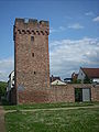
Fir tower (around 1450) as part of the city wall
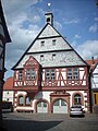
Bürgerhaus (old town hall)

Street in the old town

Ship berths and mast


.JPG)


"Neu-Wörth"
- Neustadt with residential buildings made of red sandstone, unique in the number in the Free State of Bavaria, 1883–85
- Core area with town hall (1885), former school, parish center, train station (1876), vocational school (1790), former parsonage, Wendelinus chapel (1780) and Hofgut (1795), former Neustadt inn
Churches
The site of the first parish church of St. Martin , whose origins go back to the Christianization of the Lower Main in the 6th century, is located on today's cemetery grounds on the northern edge of the city . In 1493 St. Martin was still the center of a Franconian settlement. Then the urban area shifted further and further towards the Main. In 1668 the church was separated from the settlement and stood alone in a field. Despite the construction of a new church in the city area, St. Martin remained an official parish church until 1763. Of the "original" church building, only the almost square east choir (around 1400) with ribbed cross vault is preserved today. The nave and the church tower were demolished in 1789 due to disrepair. Today the St. Martin's Chapel serves as a cemetery chapel. In 2014 the chapel was renovated according to plans by architect Helmut Becker (1935-2017) from Klingenberg and has been used as an urn burial chapel, also known as the columbarium , since April 2015 .
The second church in Wörth was St. Wolfgang's Church, which was first mentioned in 1328. The lower floors of today's tower from the 14th / 15th century are among the oldest building structure of today's church. Century. The pointed tower of the church, however, dates from 1631. The actual nave was demolished in 1729 and rebuilt between 1730 and 1749 in the Baroque style . The construction of the third parish church of St. Nicholas led to the abandonment and profanation of the church by the diocese of Würzburg in 1903 . Between 1986 and 1991, the church was converted into a shipping and shipbuilding museum .
The Wendelinus Chapel was built in 1780 by the Wörth pastor Johannes Zöller in his own garden on the upper Waisenhausstrasse. The course of the walls follows the boundaries of the property at the time, which led to a peculiar, non-rectangular floor plan. The simple construction was financed only through donations and foundations. The chapel has been used by the Evangelical Lutheran parishes of Erlenbach-Wörth and Klingenberg-Wörth since 1954. The chapel owned by the city of Wörth was renovated in 1974 and 2006.
The St. Nicholas Church was built when the city was relocated to a flood-free area in 1898. It was built from red sandstone in the style of a Romanesque basilica . On the north side of the outer wall there is a larger than life group of Mounts of Olives made of sandstone . The interior is mostly contemporary, but older, valuable art treasures can also be admired. In the transept there is a late Gothic winged altar ( Wörther Altar ) from around 1470. On the choir arch there is a carved crucifixion group (1528). Jakob Conrad Bechtold made the “Sorrowful Picture” from 1730.
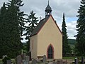
St. Martin's cemetery chapel (around 1400)

former St. Wolfgang church (now a museum)
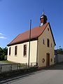
Wendelinus Chapel (1780)
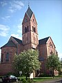
Parish Church of St. Nicholas (1898)


Others
In Wörth there is the ground monument of a Roman fort ( numerus fort ) at a point where the older line of the Neckar-Odenwald-Limes meets the Main line of the Upper German Limes . It comes from the 1st / 2nd Century and is only recognizable by weak bumps in the terrain.
The monument of a gallows , built in 1753, is located on a hill in the city, the so-called "Galgenbuckel" . It is a reminder of the city's former high jurisdiction rights . The gallows was a last-ditch effort to regain judicial rights, but was never used. The two 7 m high, round sandstone pillars that were built by the Miltenberg master builder Johann Martin Schmidt have been preserved from the gallows .
Leisure and sports facilities
Wörth is located in the Bavarian area of the Bergstrasse-Odenwald Geo-Nature Park . In the Wörther Stadtwald (1000 ha) hiking trails with a total length of over 50 km are signposted. The well-developed Main Cycle Path leads past the banks of the Main, which enables an extensive bike tour from the source of the Main to the mouth of the Rhine.
There are two soccer fields, a school sports hall, a sports park with indoor soccer, tennis, badminton and volleyball, an indoor school pool and a shooting club in Wörth. There are various sports and leisure facilities such as football pitch, table tennis, inline skating and skateboarding, as well as a playground with a barbecue hut in the vicinity of the monument.
- Mainaue and Mainruh campsites
Economy and Infrastructure
traffic
The federal highway 469 leads directly past Wörth am Main. The city can be reached from the north via the Lützelbach / Wörth exit and from the south via the Klingenberg / Wörth exit. The multi-lane B469 allows a quick connection to the Würzburg - Frankfurt motorway ( BAB 3 ).
The city has a stop on the Aschaffenburg – Miltenberg railway line . This station with a P + R car park on the single-track railway line is served by regional trains, whereas the regional express trains only stop in Klingenberg and Erlenbach. The red sandstone entrance building dates from 1876 and is used privately. There is also a connection to the bus routes 67 ( Haingrund –Wörth – Klingenberg) and 86 ( Schneeberg - Amorbach –Glanzstoffwerke) operated by the Untermain transport company .
Wörth can also be reached via the Main federal waterway . A separate ship berth is also suitable for large inland vessels. The Main Cycle Path from the Quellen to Mainz-Kastel is located on the banks of the Main .
Bike trails
The following cycle paths lead through the urban area along the Main :
- The 225 km long 3-country cycle route leads as a circular route through the triangle of Hesse, Baden-Württemberg and Bavaria. The route explores the Odenwald along the Mümling, Neckar and Main rivers.
- The German Limes Cycle Route leads from Bad Hönningen through Westerwald , Taunus and Odenwald to Regensburg, 818 kilometers away, and is based on the historical course of the Upper German-Raetian Limes .
- The Main Cycle Path leads from the two sources of the Main along the river to its confluence with the Rhine near Mainz . It has a total length of about 600 kilometers.
- The D-Route D5 (Saar-Mosel-Main) . It leads over 1,021 kilometers from Saarbrücken via Trier, Koblenz, Mainz, Frankfurt am Main, Würzburg and Bayreuth to the Czech border.
Public facilities
The City Library Wörth. Main is a community institution of the city of Wörth a. Main and the Catholic parish of St. Nicholas. It has existed since 1979 and has an inventory of around 8,000 media (as of 2009). The facility is managed and operated by a volunteer library team.
education

In Wörth am Main there are two day-care centers “Kleine Strolche” and “Rasselbande”, both of which are used as a day nursery and kindergarten .
The elementary school Wörth am Main is a primary and secondary school with all-day care in the form of an open all-day school . Around 350 pupils attend the school. Of these, around 220 are in primary school and around 135 in secondary school (status: 2010). In 2010, 126 pupils took advantage of the open all-day school.
The Theresienschule was a vocational school for housekeeping and social care. Almost 200 pupils were given the opportunity to attend school and vocational training. The school was founded in 1858 by the poor school sisters as a rescue facility for girls . Three years later it officially became a home elementary school . In 1954 it became a housekeeping school and in 1983 a vocational school. Since 2003 the Caritas Association has taken over the sponsorship. In history, the school and boarding school is also known as the girls 'home or girls' boarding school in Wörth . School operations ceased at the end of the 2011/2012 school year.
Personalities
sons and daughters of the town
- Johann Michael Fleischmann (* 1701; † 1768 in Amsterdam), typographer and type founder
- Erna Morena (born April 24, 1885, † July 20, 1962 in Munich), film actress
- Karl Franz Wolfstetter († September 28, 1991), naturalist in the field of botany
Personalities who have worked on site
- Adam Haus (1836–1895), pastor in Wörth from 1871, member of the Reichstag and Landtag
- Hans Storm (1848–1886), general practitioner in Frammersbach and Wörth, son of Theodor Storm
Oddities
In the 1840s there was a famine in Wörth and the surrounding area. The begging increased and the theft was carried up, because many fathers could not feed their families more. In 1847 the city set up a "soup establishment" for the needy. In the neighboring towns, the boys from Wörth were nicknamed "Beggar Soup Eaters".
The Wörther are also called "Schlackschisser" in their Ortsneck name . In the past, the people of Wörth always had to deal with the floods of the Main. Again and again, the old town was flooded, the roads and privies were under water as a Wörther has a malicious Erlenbacher have watched him his necessities was doing through the window (Schlack).
literature
- Trost, Werner: Wörth am Main. Chronicle of a small Franconian town. 4 volumes. Woerth 1987-1999
- Aschaffenburg Water Management Office, City of Wörth am Main: Quality of life through flood protection, Alt-Wörth - district with a future
- History of the Theresienschule Wörth: Poor school sisters leave Wörth from the parish of St. Nikolaus, accessed on August 28, 2010
Individual evidence
- ↑ "Data 2" sheet, Statistical Report A1200C 202041 Population of the municipalities, districts and administrative districts 1st quarter 2020 (population based on the 2011 census) ( help ).
- ↑ a b Website of the city of Wörth am Main: General data on the city , accessed on June 2, 2011
- ↑ a b c Internet site of the city of Wörth am Main: Information on Wörther Forest and geology , accessed on June 2, 2011
- ↑ a b Wolf-Armin von Reitzenstein : Lexicon of Franconian place names. Origin and meaning . Upper Franconia, Middle Franconia, Lower Franconia. CH Beck, Munich 2009, ISBN 978-3-406-59131-0 , p. 247 ( limited preview in Google Book search).
- ↑ a b c Internet site of the city of Wörth am Main: Wörther Geschichte , accessed on June 2, 2011
- ↑ Under the sign of shipping. Spessart project, accessed on June 15, 2015 .
- ↑ a b c d e Aschaffenburg Water Management Office, City of Wörth am Main: Quality of life through flood protection, Alt-Wörth - district with a future
- ↑ Flood protection Wörth am Main, Rhineland-Palatinate Prize of the rheinkolleg 2008 - "Flood-safe planning and building" (special prize). Retrieved July 20, 2010 .
- ↑ Elections in the Miltenberg district: Wörth
- ↑ http://www.main-echo.de/regional/kreis-miltenberg/art4001,2999021
- ↑ European elections 2019 on wahlen-in-mil.de.
- ↑ a b Bernhard Peter: Gallery: Photos of beautiful old coats of arms No. 924, Wörth am Main: Oberes Tor , accessed on September 9, 2010
- ↑ a b City and Church History ( Memento of the original from January 22, 2012 in the Internet Archive ) Info: The archive link was inserted automatically and has not yet been checked. Please check the original and archive link according to the instructions and then remove this notice. , Catholic parish of St. Nikolaus Wörth am Main, accessed on December 7, 2010.
- ↑ Website of the Ev. Trinitatisgemeinde Klingenberg / Wörth: Description of the Wendelinus Chapel , accessed on December 7, 2010
- ^ Main tours: 3.08 Wörth am Main , accessed December 21, 2010
- ↑ Church history of St. Nikolaus ( Memento of the original from December 22, 2007 in the Internet Archive ) Info: The archive link was automatically inserted and not yet checked. Please check the original and archive link according to the instructions and then remove this notice. , Catholic parish of St. Nikolaus Wörth am Main, accessed on December 20, 2010.
- ^ Werner Trost: Wörth am Main. Chronicle of a small Franconian town. Volume 4.Wörth 1999
- ↑ consolation Werner in SPESSART 1/2014
- ↑ Inexpensive on the go in the Wörth city bus ( page no longer available , search in web archives ) Info: The link was automatically marked as defective. Please check the link according to the instructions and then remove this notice. , accessed September 9, 2010
- ↑ Internet presence of the Wörth am Main City Library , accessed on June 2, 2011
- ↑ Internet presence of the elementary school Wörth am Main , accessed on June 2, 2011
- ↑ Internet presence of the vocational college Theresienschule in Wörth ( page no longer available , search in web archives ) Info: The link was automatically marked as defective. Please check the link according to the instructions and then remove this notice. , accessed June 2, 2011
- ↑ Werner Trost Stampes, Worzelköpp and Staffelbrunzer Lkr.Miltenberg 2003
Web links
- Entry on the coat of arms of Wörth am Main in the database of the House of Bavarian History
- Wörth am Main: Official statistics of the LfStat
- Wörth am Main in the location database of the Bayerische Landesbibliothek Online . Bavarian State Library

Altenbuch | Amorbach | Bürgstadt | Collenberg | Dorfprozelten | Eichenbühl | Elsenfeld | Erlenbach am Main | Eschau | Faulbach | Großheubach | Großwallstadt | Hausen | Kirchzell | Kleinheubach | Kleinwallstadt | Klingenberg am Main | Laudenbach | Leidersbach | Miltenberg | Mömlingen | Mönchberg | Neunkirchen | Niedernberg | Obernburg am Main | Röllbach | Rüdenau | Schneeberg | Stadtprozelten | Sulzbach am Main | Weilbach | Wörth a.Main
Unregulated areas: forest forest | High maintenance