Laudenbach (Lower Franconia)
| coat of arms | Germany map | |
|---|---|---|

|
Coordinates: 49 ° 45 ' N , 9 ° 11' E |
|
| Basic data | ||
| State : | Bavaria | |
| Administrative region : | Lower Franconia | |
| County : | Miltenberg | |
| Management Community : | Kleinheubach | |
| Height : | 127 m above sea level NHN | |
| Area : | 4.94 km 2 | |
| Residents: | 1461 (Dec. 31, 2019) | |
| Population density : | 296 inhabitants per km 2 | |
| Postal code : | 63925 | |
| Area code : | 09372 | |
| License plate : | MIL, OBB | |
| Community key : | 09 6 76 135 | |
| Community structure: | 1 district | |
| Address of the municipal administration: |
Obernburger Strasse 10 63925 Laudenbach |
|
| Website : | ||
| Mayor : | Stefan Distler (The Independents) | |
| Location of the municipality of Laudenbach in the Miltenberg district | ||
Laudenbach is a municipality in the Miltenberg district in Lower Franconia and a member of the Kleinheubach administrative community .
geography
Geographical location
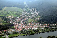
Laudenbach is located directly on the western bank of the Bavarian Lower Main between Miltenberg and Obernburg and borders the Odenwald . The town is well connected to the road network via the B 469 , and the center of the Rhine-Main area can be reached quickly by car and train .
The topographically highest point of the municipality district is located at 413 m above sea level. NN on the mountain "Auf der Höhe", south of Laudenbach, the lowest is in the Main at 120.5 m above sea level. NN .
Community structure
The community of Laudenbach is not divided into districts.
Neighboring communities
The district of Laudenbach joins the neighboring community of Klingenberg am Main to the north (downstream) , with the district of Trennfurt and on the other side of the Grubingen desert , east of the Main and the district of Großheubach , upstream (south) of Kleinheubach and to the west the state of Hesse with Michelstadt and the district of Vielbrunn . Laudenbach is connected to the Odenwald via a district road and the hamlets of Brunnthal and Bremhof .
Surname
etymology
It takes its name from the eponymous Laudenbach Laudenbach , which opens in the Main.
Earlier spellings
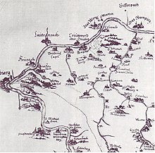
Earlier spellings of the place from various historical maps and documents:
|
|
history
Since 1315 Laudenbach was owned by the imperial barons of Fechenbach . In the course of the reorganization of Germany under Napoleon , the place came to the Grand Duchy of Hesse in 1810 . By contract of January 29, 1817, Laudenbach, together with the towns of Umpfenbach , Windischbuchen and Reichartshausen , came to the Kingdom of Bavaria in exchange for Dorndiel , Mosbach and Radheim from the Grand Duchy of Hesse . In 1862 the Miltenberg District Office was formed, on whose administrative area Laudenbach lay. As everywhere in the German Reich , the term district was introduced in 1939. Laudenbach was now one of the 31 communities in the old district of Miltenberg . On July 1, 1972, this merged with the district of Obernburg am Main to form the new district of Miltenberg .
Incorporations
The hamlet of Brunnthal in Hesse , which belongs to Vielbrunn (district of Michelstadt ) but is closer to Laudenbach , is co-administered from Laudenbach.
Population development
There has been a slight increase in the number of inhabitants in recent years, which is mainly due to the development of new building areas (e.g. Sommerberg II, Bocksberg).
politics
mayor
Stefan Distler (The Independent) has been mayor since May 1, 2020. His predecessor was Bernd Klein (Free Voters), in office from May 2008 to April 2020.
| Parties and constituencies | % 2014 |
Seats 2014 |
% 2008 |
Seats 2008 |
||
|---|---|---|---|---|---|---|
| SPD | Social Democratic Party of Germany | 21.7 | 3 | 18.08 | 2 | |
| CSU | Christian-Social Union in Bavaria | 32.9 | 4th | 36.89 | 4th | |
| FWG | Free group of voters | 45.4 | 5 | 45.03 | 6th | |
| total | 100.0 | 12 | 100.0 | 12 | ||
| Voter turnout in% | 70.9% | 76.04% | ||||
coat of arms
The description reads: “Angled left divided by a blue wavy bar; above five times divided by gold and red, below in silver a curved black fenugreek. "
Infrastructure
traffic
The Laudenbach stop (b Kleinheubach) is on the Aschaffenburg – Miltenberg railway line . The federal highway 469 runs on the eastern edge of Laudenbach and the district road MIL3 leads west into the Odenwald to Vielbrunn . The next motorway junction 57 (Kreuz Stockstadt am Main ) of the federal motorway 3 is about 31 km away via the B 469.
Long-distance cycle routes
The following cycle paths lead through the village along the Main :
- The German Limes Cycle Route leads from Bad Hönningen through Westerwald , Taunus and Odenwald to Regensburg, 818 kilometers away, and is based on the historical course of the Upper German-Raetian Limes .
- The Main Cycle Path leads from the two sources of the Main along the river to its confluence with the Rhine near Mainz . It has a total length of about 600 kilometers.
- The D-Route D5 (Saar-Mosel-Main) . It leads over 1,021 kilometers from Saarbrücken via Trier, Koblenz, Mainz, Frankfurt am Main, Würzburg and Bayreuth to the Czech border.
- The 225 km long 3-country cycle route leads as a circular route through the triangle of Hesse, Baden-Württemberg and Bavaria. The route explores the Odenwald along the Mümling, Neckar and Main rivers.
Public facilities
- The Kleinheubach middle school has a branch office in Laudenbach for the primary area.
- The Karolusheim day care center.
Culture and sights
music
- Musikverein Harmonie
- Laudenbach's lust for singing
- INTAKT - the choir
societies
- Volunteer firefighter
- Homeland and history association
- Gymnastics club
- Fishing club ASV Laudenbach on the Main Valley Cycle Path
- Motorcycle club
- Football club Kickers 1949 Laudenbach
- Archery club
Buildings
Laudenbach Castle
The imperial barons of Fechenbach were local and later castle lords for over 600 years. The widow of Field Marshal Lieutenant Reichart von Fechenbach, Josepha b. von Eyb , had today's baroque palace built between 1717 and 1747. The main building consists of two two-storey wings that meet at right angles. The castle chapel was built in 1755 by the later titular bishop of Taenarum, Johann Philipp Karl von Fechenbach . The palace complex is located in a picturesque park with rare trees. From 1923 to 2001 the castle was inherited by the Barons von und zu Aufseß . In 2002, Prince Aloys-Konstantin zu Löwenstein-Wertheim-Rosenberg from Kleinheubach bought the castle as a residence for his son, Hereditary Prince Carl Friedrich (1966-2010), whose family still lives there today.
Parks
- Laudenbach Castle Park
Natural monuments
- Sequoia in the palace gardens
Regular events
- Parish and kindergarten festival in summer
- Main bank festival of the football club in summer
- Midsummer bonfire of the choral society
- May celebration of the music association
- Fountain festival of the gymnastics club
- Event trip and final trip of the motorcycle club
- Theater event by the Laudenbach Theater Truppe for well over 40 years. Usually in April / May
education
Primary and secondary school within the school association Kleinheubach / Laudenbach / Rüdenau
Oddities
While the Breitendielers were the "Hasenbäuerli", the Laudenbachers were the "Kröpfer". A particularly popular domestic pigeon breed among pigeon breeders was the Brno Kröpfer . Later the racing pigeons were added, loft communities were formed and prizes, awards and trophies were achieved . The "Laudenbacher Kröpfer" had long received the nickname or place name from their neighboring towns.
Sons and daughters of the church
- Franz Ignatz Uhrig (born March 1, 1820 in Laudenbach; † February 9, 1861 in St. Louis), brewer and restaurateur in St. Louis
- Franz Joseph Uhrig (born July 2, 1808 in Laudenbach; † July 2, 1874), Ignatz's older brother, transport company, brewer and restaurateur in St. Louis
Individual evidence
- ↑ "Data 2" sheet, Statistical Report A1200C 202041 Population of the municipalities, districts and administrative districts 1st quarter 2020 (population based on the 2011 census) ( help ).
- ^ Bayerische -Landesbibliothek-online , accessed in January 2013
- ↑ a b Wolf-Armin von Reitzenstein : Lexicon of Franconian place names. Origin and meaning . Upper Franconia, Middle Franconia, Lower Franconia. CH Beck, Munich 2009, ISBN 978-3-406-59131-0 , p. 128 ( limited preview in Google Book search).
- ↑ Result on the parish homepage , accessed on June 23, 2020
- ↑ Statistics communal 2015: Laudenbach municipality , p. 10 of the Bavarian State Office for Statistics; accessed on January 2, 2017
- ^ Municipal council election 2008 - Laudenbach ; accessed on January 2, 2017
- ↑ Werner Trost: Stampes, Worzelköpp and Staffelbrunzer , District Court Miltenberg 2003
Web links
- http://www.laudenbach-am-main.de/home/index.html
- Entry on the coat of arms of Laudenbach (Lower Franconia) in the database of the House of Bavarian History


