Rhine Main Area
|
Rhine-Main area Metropolitan area Frankfurt / Rhine-Main |
|
|---|---|
|
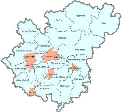
Cities and districts of the Rhine-Main area according to IHK delimitation (highlighted in orange: independent cities) |
|
| Federal states : |
|
| Administrative districts / regions: |
Region of Darmstadt , Giessen Region , Region of Kassel , Region Rheinhessen , Administrative district Lower Franconia |
| Area : | 14,755 km² |
| Residents : | 5,782,217 (December 31, 2018) |
| Population density : | 392 inhabitants / km² |
| North South expansion: | 156 km |
| West-east expansion: | 168 km |
| geographical location : | 49 ° 23 ′ - 50 ° 50 ′ n. Br. 7 ° 44 ′ - 10 ° 05 ′ east. |
| administrative structure: | 18 districts , 7 independent cities |
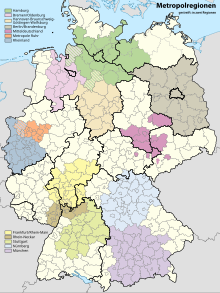
The Rhine-Main area , also known as the Frankfurt / Rhein-Main metropolitan region , is one of the eleven metropolitan regions in Germany defined by the German Ministerial Conference for Spatial Planning . It is named after the two rivers Main and Rhine and is located in the south of Hesse and parts of the neighboring states of Rhineland-Palatinate ( Rheinhessen ) and Bavaria ( Lower Franconia ) . The core of the metropolitan region is the urban agglomeration of Frankfurt / Rhine-Main . The Rhine-Main area has a total of around 5.7 million inhabitants, of which around 2.2 million live in the Frankfurt / Rhine-Main conurbation.
The Rhine-Main area is the geographic center of Germany and Europe.
Core cities
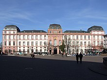
The region is a polycentric densely populated area whose economically and politically most important cities are Frankfurt am Main , Wiesbaden , Mainz and Darmstadt . The city of Frankfurt am Main is the functional and geographical center.
Other urban centers in the region are Rüsselsheim am Main , Groß-Gerau , Bad Homburg vor der Höhe , Offenbach am Main , Hanau , Aschaffenburg , Gießen , Limburg an der Lahn and Fulda .
Demarcation
Frankfurt / Rhine-Main metropolitan region
The area of the chambers of industry and commerce , which are members of the IHK Forum Rhein-Main , encompasses the entire economic region. This gives you the following generous delimitation, corresponding to the Frankfurt / Rhine-Main metropolitan region:
| city | Resident December 31, 2019 |
Area km² | Inhabitants / km² mean |
country |
|---|---|---|---|---|
| Frankfurt am Main | 763.380 | 248 | 3078 |
|
| Offenbach am Main | 130.280 | 45 | 2895 |
|
| Wiesbaden , state capital | 278.474 | 204 | 1365 |
|
| Mainz , state capital | 218,578 | 98 | 2230 |
|
| Worms | 83,542 | 109 | 766 |
|
| Darmstadt | 159,878 | 122 | 1310 |
|
| Aschaffenburg | 71.002 | 62 | 1145 |
|
| total | 1705.134 | 888 | 1903 |
| district | Resident December 31, 2019 |
Area km² | Inhabitants / km² mean |
country |
|---|---|---|---|---|
| Main-Taunus-Kreis | 238,558 | 222 | 1075 |
|
| Hochtaunuskreis | 236.914 | 482 | 492 |
|
| Wetteraukreis | 308,339 | 1.101 | 280 |
|
| Main-Kinzig district | 420,552 | 1,398 | 301 |
|
| Offenbach district | 355.813 | 356 | 999 |
|
| Groß-Gerau district | 275,726 | 453 | 609 |
|
| Aschaffenburg district | 174,200 | 699 | 249 |
|
| Miltenberg district | 128,743 | 716 | 180 |
|
| Darmstadt-Dieburg district | 297,844 | 659 | 452 |
|
| Odenwaldkreis | 96,703 | 624 | 155 |
|
| Bergstrasse district | 270,340 | 720 | 375 |
|
| Alzey-Worms district | 129,687 | 588 | 221 |
|
| Mainz-Bingen district | 211,417 | 606 | 349 |
|
| Rheingau-Taunus district | 187.160 | 811 | 231 |
|
| Limburg-Weilburg district | 171,912 | 738 | 233 |
|
| District of Giessen | 270,688 | 855 | 317 |
|
| Vogelsbergkreis | 105,643 | 1,459 | 72 |
|
| District of Fulda | 223.145 | 1,380 | 162 |
|
| total | 4103.384 | 13,867 | 295 |
| Resident December 31, 2019 |
Area km² | Inhabitants / km² mean |
|
|---|---|---|---|
| One district cities | 1,690,324 | 888 | 1903 |
| Counties | 4,091,893 | 13,867 | 295 |
| total | 5,782,217 | 14,755 | 392 |
The Lahn-Dill district is not included here, as it is not part of the European metropolitan region of Frankfurt / Rhine-Main, although historically it belongs to the Rhine-Main area.
The Bergstrasse district and the city of Worms are in the overlap area with the neighboring Rhine-Neckar metropolitan region .
Commuter links
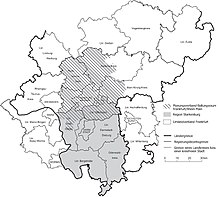
The “Rhine-Main Research” department (located at the Geographical Institutes of the Goethe University in Frankfurt from 1925 to 2005) similarly delimits the region on the basis of commuter links - the core cities of the region are Frankfurt, Wiesbaden, Offenbach, Darmstadt and Hanau in Hesse as well as Aschaffenburg in Bavaria and Mainz in Rhineland-Palatinate. With a total of around 4.9 million inhabitants on an area of approximately 11,000 km², the region also includes the administrative district Darmstadt , the administrative district Limburg-Weilburg ( administrative district Gießen ) as well as the administrative district Aschaffenburg and the administrative district Miltenberg from Bavaria and the administrative district Mainz-Bingen, the city of Worms and the district of Alzey-Worms from Rhineland-Palatinate. The expansion of the IHK forum in the north to include the IHK districts of Gießen-Friedberg makes little sense from the point of view of the scientists, as only a few interdependencies with the core of the region can be proven from these districts.

Functional urban area
Eurostat , the statistical office of the European Union , uses the harmonized concept of the urban region ( Functional Urban Area , until 2013 Larger Urban Zone ). The urban region DE005C Frankfurt am Main has been used for statistical surveys as part of the Urban Audit since 2004 . According to this definition, the following administrative units belong to the Frankfurt metropolitan area:
- City of Frankfurt am Main
- City of Offenbach am Main
- Main-Taunus-Kreis
- Hochtaunuskreis
- Wetteraukreis
- Main-Kinzig district
- Offenbach district
- Groß-Gerau district
2,729,562 inhabitants live in the region thus delimited with a total of 4305 square kilometers (as of December 31, 2019)
The metropolitan region also includes the city regions DE020C Wiesbaden with 462,098 inhabitants, DE025C Darmstadt with 439,084 inhabitants and DE037C Mainz with 403,849 inhabitants.
Regional association FrankfurtRheinMain
The law on the Frankfurt / Rhine-Main metropolitan region of the Hessian State Parliament of March 11, 2011 defines the narrower metropolitan area of Frankfurt am Main as follows:
- The independent cities of Frankfurt am Main and Offenbach am Main;
- in the districts of Hochtaunuskreis, Main-Taunus-Kreis and Offenbach, all cities and communities;
- in the Main-Kinzig district the towns of Bruchköbel , Erlensee , Hanau , Langenselbold , Maintal , Nidderau and the communities of Großkrotzenburg , Hammersbach , Neuberg , Niederdorfelden , Rodenbach , Ronneburg , Schöneck ;
- in the Wetterau district the cities of Bad Nauheim , Bad Vilbel , Butzbach , Florstadt , Friedberg (Hesse) , Karben , Münzenberg , Niddatal , Reichelsheim (Wetterau) , Rosbach vor der Höhe and the municipalities of Ober-Mörlen , Rockenberg , Wölfersheim , Wöllstadt ;
- in the district of Groß-Gerau the towns of Ginsheim-Gustavsburg , Groß-Gerau , Kelsterbach , Mörfelden-Walldorf , Raunheim , Rüsselsheim am Main and the communities of Bischofsheim , Nauheim .
This area has about 2.2 million inhabitants on an area of 2,500 km².
Rhein-Main S-Bahn
The metropolitan area, which roughly corresponds to the size of the S-Bahn network , extends from the area around Wiesbaden and Mainz in the west to Aschaffenburg in the east and from Friedberg and Bad Nauheim in the north to Darmstadt in the south. This area has 3.4 million inhabitants on an area of 5,500 km².
Rhein-Main transport association
The catchment area of the Rhine-Main area is very large. Around 350,000 commuters come to the Frankfurt area every day, some of whom live far more than 100 km from their workplace. The commuter catchment area includes the entire Odenwald, the southern Palatinate, the Rhön, the Taunus, the Westerwald, the Marburg / Gießen / Wetzlar region and the Electoral Palatinate. It is therefore no coincidence that the Rhein-Main-Verkehrsverbund (RMV) is the third largest German transport association .
The Frankfurt / Rhein-Main metropolitan region includes the following cities with a population of 30,000 or more (as of December 31, 2015; the last two columns show that they belong to the narrower regional association Frankfurt / Rhein-Main (BAFRM) and the former association Region Starkenburg (RGSTARK) specified):
| city | Residents | country | BAFRM | RGSTARK |
|---|---|---|---|---|
| Frankfurt am Main | 763.380 |
|
Yes | No |
| Wiesbaden , state capital | 278.474 |
|
No | No |
| Mainz , state capital | 218,578 |
|
No | No |
| Darmstadt | 159,878 |
|
No | Yes |
| Offenbach am Main | 130.280 |
|
Yes | No |
| Hanau | 96,492 |
|
Yes | No |
| Worms | 83,542 |
|
No | No |
| to water | 89,802 |
|
No | No |
| Aschaffenburg | 71.002 |
|
No | No |
| Fulda | 68,635 |
|
No | No |
| Rüsselsheim am Main | 65,881 |
|
Yes | No |
| Bad Homburg vor der Höhe | 54,227 |
|
Yes | No |
| Oberursel (Taunus) | 46,545 |
|
Yes | No |
| Rodgau | 45,719 |
|
Yes | Yes |
| Dreieich | 42.102 |
|
Yes | Yes |
| Bensheim | 40,756 |
|
No | Yes |
| Hofheim am Taunus | 39,647 |
|
Yes | No |
| Main valley | 39,553 |
|
Yes | Yes |
| Neu-Isenburg | 38.105 |
|
Yes | Yes |
| Langen (Hesse) | 38,229 |
|
Yes | Yes |
| Moerfelden-Walldorf | 34,891 |
|
Yes | Yes |
| Limburg on the Lahn | 35,514 |
|
No | No |
| Dietzenbach | 34,298 |
|
Yes | Yes |
| Viernheim | 34,315 |
|
No | Yes |
| Bad Vilbel | 34,216 |
|
Yes | No |
| Lampertheim | 32,598 |
|
No | Yes |
| Bad Nauheim | 32,447 |
|
Yes | No |
economy
The central and easily accessible location in southwest Germany promoted the industrialization of the region as early as the middle of the 19th century . Companies from many industries here have their headquarters and employ in the region of about 1.8 million workers . 7.9% of German gross value added is generated in the Frankfurt Rhine-Main region. The part of the region that belongs to Hesse generates 78% of Hesse's gross domestic product. These figures underline the position of Frankfurt Rhein-Main as one of the most important metropolitan regions in Germany - according to European standards. In downtown Frankfurt, banks and investment companies as well as the European Central Bank predominate . The chemical industry has been located in the region for a long time, especially in the Höchst industrial park . Other services have established themselves in the wider environment, with the automotive industry playing a key role. Many of them have a European or German headquarters, often with research and design centers. The construction and real estate industry is also one of the economic heavyweights in the region, with a share of 18% of the regional gross value added. Darmstadt and Wiesbaden have established themselves as science cities with the headquarters of federal authorities and insurance companies .
The logistics area is particularly favored by Frankfurt am Main Airport and the central connection to the motorway and railway network . The Frankfurter Kreuz and Frankfurt Hauptbahnhof are each the busiest in Europe. Munich , Hamburg , the Benelux countries, Paris , Switzerland , Austria , the Czech Republic , Poland and Berlin can be reached in a few hours . Other important long-distance train stations are Mainz Hbf , Frankfurt Süd and Frankfurt Airport long-distance train station . Many destinations around the world can be reached as direct flights via Frankfurt Airport . The infrastructure in the Rhine-Main area is considered to be very well developed.
Natural space
The scenic attractiveness of the region results from the contrast between the plains of the two eponymous rivers and the low mountain ranges that border the region .
The Lower Main Level is the northern branch of the Upper Rhine Plain , which extends from Basel to Frankfurt. The Middle Rhine breaks through the Rhenish Slate Mountains in a narrow, sometimes gorge-like valley . In addition to the two rivers mentioned, the Nidda , Kinzig and Nahe are important rivers in the region, and the Lahn on its northern edge .
The region is bounded by five low mountain ranges: Taunus , Vogelsberg , Spessart , Odenwald and Hunsrück . The southern slope of the Taunus ( Rheingau ) and the western slope of the Odenwald ( Bergstrasse ) are climatically among the mildest areas in Germany.
The Rheingau, the Rheinhessen area on the left bank of the Rhine , the Hessian Bergstrasse and the Lower Franconian Main Valley are wine-growing areas . The agriculture in the Wetterau in the northern region has soils that are among the most profitable in Germany. In the densely populated core area of the Frankfurt region, the open spaces are used more for local recreation than for agriculture. Typical for the landscape there are meadow orchards , the yields of which are mostly used for the production of Frankfurt apple wine .
The large Kühkopf nature reserve is located in the Hessian Ried directly on the Rhine .
history
A peculiarity of the region that is still valid today is that there has never been a territorial unit of the Rhine-Main area in history. The region owes its cultural diversity to the thousand-year-old small states , but also the lack of cooperation and coordination in contrast to competing metropolitan regions.
Ancient and Middle Ages
In Roman times the region was on the border of the empire . Mainz, under the name Mogontiacum, was the capital of the province of Upper Germany , the Limes protected the imperial border and ran over the ridge of the Taunus and across the Wetterau. In addition to Mainz, there were numerous Roman forts in the region (Hofheim, Höchst, Frankfurt, Kleiner Feldberg , Saalburg, etc.) and the city of Nida (near Frankfurt-Heddernheim ). Even then, Wiesbaden was an important seaside resort ( Aquae Mattiacorum ) .
Already in late Roman antiquity (since 343) Mainz became a bishopric , which in the early Middle Ages became one of the most important of the Franconian and later the German Empire. Franconian kings ( Merovingians , later Carolingians ) established royal courts , a. a. in Frankfurt and Ingelheim . The Lorsch Abbey was one of the most powerful land grants in Germany. Due to the favorable traffic situation, the region was able to attract trade traffic, important roads were built, such as the Via Regia .
In the late Middle Ages, Frankfurt replaced Mainz as the most important city in the region. Frankfurt, Friedberg (Hessen) , Wetzlar and Gelnhausen (the latter with the imperial palace of the Staufer ) were free imperial cities . The archbishops of Mainz were arch chancellors of the empire and one of the seven electors . Frankfurt owed its rise to its role as an important trade fair city and as a place of choice , later also to the coronation of the Roman-German kings and emperors .
19th century
The Archdiocese of Mainz comprised large areas in the west and east (around Aschaffenburg) of the Rhine-Main area until it was dissolved in 1803. After the Congress of Vienna , from 1816, the region was divided into the following territories:
- Grand Duchy of Hesse (capital Darmstadt), with the provinces of Starkenburg (Darmstadt, Offenbach), Rheinhessen (Mainz, Worms, Bingen) and Upper Hesse (Gießen, Friedberg).
- City of Wetzlar and Wetzlar District , today Lahn-Dill District , in the Prussian Rhine Province
- Duchy of Nassau (capital Wiesbaden), with Limburg and Höchst.
- Electorate of Hesse (capital Kassel ), with Gelnhausen, Hanau, Bergen and Bockenheim
- Landgraviate of Hessen-Homburg (Bad Homburg)
- Kingdom of Bavaria (Aschaffenburg)
- Free City of Frankfurt (city-state)
After the Prussian-German War in 1866 , Prussia annexed all of the aforementioned territories except for the Grand Duchy of Hesse and the Kingdom of Bavaria, which had to cede smaller parts of the territory. The territorial fragmentation continued, however, as the Grand Duchy of Hesse remained divided into two parts by the city of Frankfurt and the adjoining Hanau district.
20th century
The actual history of the "Rhine-Main region" or the "Rhine-Main region" in the literal sense begins at the end of the 19th century when a regional context was debated for the first time and the term Rhine-Main region was coined. Then as now, the region as such remained indefinite within its boundaries. In the 1920s there were first attempts to pave the way for regional cooperation and to distribute functions in the region - testimony to this attempt is the plan of a "Rhein-Mainischen Städtkranze", which was drawn up by the then mayor of Frankfurt, Ludwig Landmann, immediately after taking office in 1924 was presented. Landmann saw the Rhine-Main area with Frankfurt in the center of a south-west German catchment area, for which, as part of the discussions about the so-called imperial reform, even Frankfurt plans for a separate new imperial state "Rhine Franconia" were launched. The importance that was attached to the region in the late 1920s is also shown by the establishment of a separate research department “ Rhein-Mainische Forschung ” at the Geographical Institute of the Goethe University in Frankfurt. With the “Rhine-Main Atlas” in 1929, it not only presented the first ever German regional atlas, but also defined the region's boundaries for the first time: this stretched from Kassel in the north and Aschaffenburg in the east to Koblenz in the west and Saarbrücken in the south.
During the time of National Socialism , the region was briefly politically combined in the NS Gau Hessen-Nassau - this only existed for a short time, but is the first political institutionalization of the Rhine-Main area. In 1945 the border to the French occupation zone , which was later set up at the expense of the British and American zones, was arbitrarily determined by the Allies in the Rhine. The occupying powers subsequently founded the federal states that still exist today on their own territory. With the (French) establishment of the new state of Rhineland-Palatinate , Rheinhessen was separated from Hesse, and the region (and even the city of Mainz) was administratively divided again.
The unresolved Rhine-Main question
With the advent of regional planning in Germany , a phase of institutionalization began in the Rhine-Main area, especially in the narrower urban region of Frankfurt . Due to strong suburbanization , a solution to the problems at hand on a regional scale became more and more urgent. During the 1960s there was a long struggle for urban district and regional city models, which would always have meant the elimination of administrative levels. In 1975, as a compromise, the Frankfurt Umlandverband (UVF) was brought into being by state law - this was a so-called multi - purpose compulsory association and was supposed to take on numerous tasks: On the one hand, it was supposed to take over the land use planning for the 43 member municipalities as part of a joint land use plan. There were also numerous sponsorship tasks, B. water supply and sewage disposal, waste disposal, regional leisure facilities and the like. a. The UVF could not fulfill its tasks everywhere, however, because numerous facilities were not left to it as intended.
The surrounding association quickly came under fire. This culminated in 1995 in the so-called “Jordan Paper” of the SPD district of Hessen-Süd, which proposed a reorganization of the Darmstadt administrative district by regional districts .
In 1999, the newly elected state government under Roland Koch took up the criticism of the surrounding area and created a new regional structure with the conurbation law in 2000 : the Frankfurt / Rhine-Main Area Association was replaced by the planning association for the Frankfurt / Rhein-Main area , the range of tasks was reduced to planning and the area of the association (Metropolitan area) expanded from 43 to 75 municipalities. All sponsorship tasks of the UVF should be voluntarily organized in the region and directed by a “council of the region”, made up of mayors and district administrators. A democratic legitimation of this construct was dispensed with, the parliament of the surrounding association was replaced by the association chamber of the planning association. Compared to other regionalizations, however, the delimitation of the agglomeration clearly lags behind the actual economic ties between the core cities and their surrounding areas. In the meantime, the state government has made use of its right to prescribe regional cooperation twice: On the one hand, the FrankfurtRheinMain Region Economic Development Corporation was founded as a joint venture between several core cities and several districts (2005). This should strive for the uniform marketing and presentation of the region. The deadline set by the state government for the formation of a cultural association is still running - however, since some municipalities suspect a redistribution of funds in favor of the core city of Frankfurt and its cultural offerings, numerous affected municipalities strictly reject this association. The cities of Hanau and Offenbach have filed lawsuits with the Hessian administrative court.
The metropolitan area law was heavily criticized from the start, z. B. because of the state government's right to intervene, with which this regional cooperation can be initiated by decree, and because of the lack of democratic legitimation. As a result, numerous initiatives were started that attempted to reorganize the region: For example, the mayor of Frankfurt, Petra Roth, presented a “ city district model ” which envisaged the amalgamation of Frankfurt with its neighboring communities in one district. The SPD Hessen presented a concept with which Hessen was to be divided into four regional districts. However, none of the concepts has been able to prevail so far, so that the Rhine-Main region is still politically fragmented.
The goal of a "united" region is also pursued by numerous initiatives in the region. B. the Metropolitana , emerged from a series of articles in the Frankfurter Rundschau (2000–2001), which was formed as an association and later merged with the FrankfurtRheinMain business initiative. With the help of a building exhibition - comparable to the IBA Emscher Park in the Ruhr area - regional awareness in the region should be promoted several times. An IBA was already discussed in connection with the Metropolitana, the idea was taken up in 2004 and a Frankfurt architecture and planning office was commissioned with a feasibility study, which was to be presented in 2005. The IHK Forum Rhein-Main is one of the initiatives that endeavor to (politically) strengthen the region.
The Rhein-Main regional workshop was formed as a citizens' initiative at the beginning of 2004. Under the leadership of the FrankfurtRheinMain business initiative, ideas on the future of the region were collected in a workshop. Although the response was great at the beginning, the organizers were unable to carry on the enthusiasm for the idea of a Rhine-Main region, so that the initiative came to nothing.
At the initiative and invitation of the Lord Mayor of Frankfurt Peter Feldmann , a “Day of the Metropolitan Region” took place on April 17, 2015 in the Paulskirche . Several hundred representatives from municipalities and business were invited, and the then President of the European Parliament Martin Schulz gave a speech. A declaration calls for the adoption of a state treaty between Hesse, Rhineland-Palatinate and Bavaria.
The FrankfurtRheinMain Strategy Forum met for the first time on January 18, 2018 . Under the chairmanship of the head of the Hessian State Chancellery, Axel Wintermeyer , it gathers representatives of the state governments of Hesse, Rhineland-Palatinate, Bavaria and Baden-Württemberg, municipal representatives as well as representatives of chambers of industry and commerce. As an informal body, it wants to develop recommendations, but has no decision-making powers.
Church responsibilities
Protestant church
With the exception of the Bavarian area and the Frankfurt district of Bergen-Enkheim and the Main-Kinzig district, the Rhine-Main area belongs to the Evangelical Church in Hesse and Nassau . Main-Kinzig and Bergen-Enkheim belong to the Evangelical Church of Kurhessen-Waldeck . Aschaffenburg and Miltenberg belong to the Evangelical Lutheran Church in Bavaria .
Catholic Church
In the Catholic Church, four dioceses have a share in the region, namely Mainz in the areas that formerly belonged to Hessen-Darmstadt, Limburg in the communities that formerly belonged to Nassau, Frankfurt and Hessen-Homburg, and Fulda in the formerly Kurhessische places. In this regard, the city of Frankfurt is divided into three parts. The two Bavarian districts around Aschaffenburg belong to the diocese of Würzburg .
Main sights

- In Frankfurt: Old Town with Kaiserdom , Römerberg , Paulskirche , Goethe House and Main riverbank with Eisernem Steg , Museumufer ; further city with old opera , stock exchange with bull and bear, Hauptwache , high-rise skyline , main station , fair , palm garden and zoo ; Sachsenhausen with apple wine taverns and Henninger Tower , also the preserved Höchst old town with the Justinuskirche and the Höchst Castle ; the Frankfurt airport .
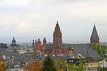
- In Mainz: Cathedral , St. Stephen's Church , Electoral Palace , Gutenberg Museum , Roman-Germanic Central Museum , Theodor-Heuss-Bridge , the Roman stones , the citadel with Drususstein and the Dativius-Victor arch .
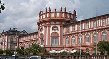
- In Wiesbaden: Bowling Green with Kurhaus and State Theater , Kurpark , Wilhelmstrasse and Warmer Damm , Hessisches Landesmuseum Wiesbaden , Schlossplatz with Market Church , Old and New Town Hall and the City Palace (today the Hessian Parliament ), Luisenplatz with St. Bonifatius , Ringstrasse (1st ring) with the Ringkirche , Neroberg with the Nerobergbahn , Biebrich Castle , Reduit Fortress , Theodor-Heuss-Bridge and the " Russian Orthodox Church ".
- In Darmstadt and the Darmstadt-Dieburg district: Mathildenhöhe artists' colony with wedding tower , Luisenplatz with Ludwigsmonument , Residenzschloss , Rosenhöhe Park , Hessisches Landesmuseum Darmstadt , Kranichstein hunting lodge , Messel pit fossil site (10 km north), Frankenstein Castle .
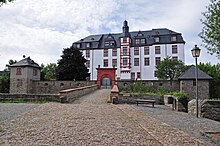
- In Aschaffenburg and the surrounding area: Johannisburg Palace , Pompejanum , Schönbusch Park and Palace , Schönborner Hof , St. Peter and Alexander Abbey Basilica , the historic old town on the Stiftsberg and the moated Mespelbrunn Castle .
- In Offenbach: German Leather Museum , Klingspor Museum , Isenburger Schloss , Büsing-Palais , Büsing-Park , Lili-Tempel with Lilipark, Rumpenheimer Schloss , City Tower , French Reformed Church , Evangelical City Church , Offenbach Fair , Town Hall, Marienkirche , Wilhelmsplatz with Weekly market, Kaiserleibrücke , forest zoo, town house, Carl-Ulrich-Brücke , Alt-Bieber , bicycle shed, Offenbach barrage , former Heyne factory , Dreieich-Park , Leonhard-Eißnert-Park , weather park , former slaughterhouse area.
- In Rheinhessen : Worms Cathedral , Ingelheimer Kaiserpfalz , Oppenheimer Katharinenkirche , Guntersblumer Kellerweg , Binger Drususbrücke .
- In the Taunus: palaces and fortresses in Bad Homburg , Kronberg , Königstein , Falkenstein , Idstein and Eppstein ; Limes with Limes Fort Kleiner Feldberg , Saalburg and Braunfels ; Großer Feldberg and Altkönig ; Main-Taunus Arboretum between Schwalbach and Sulzbach; Spa facilities in Bad Homburg ( spa gardens ) and Bad Soden as well as historic old towns in Oberursel (Taunus) and Idstein.
- In Hanau and the surrounding area: Hanau with the German goldsmith's house , Philippsruhe Castle , Wilhelmsbad health resort and the old town of Steinheim , Gelnhausen with the Kaiserpfalz and Marienkirche , Seligenstadt with the old town and Einhard's basilica .
- On Bergstrasse , in Ried and in the Odenwald: Lorsch Abbey , Bensheim with the Prince's Camp and Auerbach Castle , Heppenheim with Starkenburg , Zwingenberg , Breuberg Castle , Erbach (Odenwald) and Michelstadt .
- In the Rheingau: Numerous monasteries, u. a. Eberbach and Johannisberg Castle ; Wine towns like Rüdesheim am Rhein with the Drosselgasse , Oestrich-Winkel , Geisenheim and Eltville am Rhein ; Niederwald Monument .
- In the Wetterau: Old towns of Friedberg (castle) and Büdingen (city fortifications), Art Nouveau spa facilities in Bad Nauheim and the important Celtic fortifications in Glauburg on the Glauberg with the research center Keltenwelt am Glauberg .
- In Rüsselsheim: Rüsselsheimer fortress with award-winning industrial museum, art and exhibition center Opel-Villen, Verna-Park (a listed English landscape garden from the late Romantic period).
- In Limburg: Cathedral , the Staurothek and the historic old town.
- In Heusenstamm: Heusenstamm Castle (Schönborn Castle), gate building , old town, Hoher Berg .
Culture
In the cultural region of Frankfurt / Rhine-Main , 46 cities and districts of the Rhine-Main area and the regional association have come together. The non-profit company has been promoting cooperation between the municipalities since 2005 and providing information on cultural offers and events in the region. In the route of industrial culture, 1,000 industrial buildings are linked on the 160 km between Miltenberg and Bingen am Rhein to form an adventure route across the industrial age.
The Frankfurt / Rhein-Main cultural fund has been coordinating and promoting cultural projects in the region since 2007. Hessian cities and districts in the region and the state of Hesse contribute to the fund.
literature
- Monstadt, Jochen; Zimmermann, Karsten; Robischon, Tobias; Schönig, Barbara (Ed.) 2012: The discussed region: Problems and planning approaches in the Rhine-Main metropolitan region. Campus Verlag, Frankfurt / New York, ISBN 3-593-39654-8 , ( online )
- Oliver M. Piecha: The dream of Greater Frankfurt. Visions of the Rhine-Main from the twenties. In: Research Frankfurt. 1, 2005, pp. 41-44.
- Laurenz Pries u. a .: Endangerment of the forests in the Rhine-Main area. Concepts for forest conservation and forest stabilization . (= Notices from the Hessian Forest Administration. Volume 35). Published by the Hessian Ministry for the Environment, Agriculture and Forests. Sauerländer, Frankfurt am Main 1999, ISBN 3-89051-222-4 .
- Institute for cultural geography, urban and regional research: Rhine-Main regional atlas. Nature - society - economy. (= Rhein-Mainische-Forschungen. Issue 120). Frankfurt am Main 2000, ISBN 3-923184-26-3 .
- Jens Peter Scheller: Rhine-Main. A region on the way to political existence. (= Materials from the Institute for Cultural Geography, Urban and Regional Research. Issue 25). 1998, ISBN 3-923218-18-4 .
- Klaus Wolf, Franz Schymik (ed.): 75 years of research on the Rhine-Main region. 1925-2000. (= Rhein-Mainische research. Issue 119). 2000, ISBN 3-923184-25-5 .
- Walter Behrmann, Otto Maull: Rhein-Mainischer Atlas for economy, administration and teaching. 1929.
- C. Langhagen-Rohrbach: Current regionalization processes in the Rhine-Main region. In: spatial research and spatial planning. Issue 1/2004. Hanover 2004, pp. 58-66.
- Holger Zinn: The Rhine-Main area in the mirror of the official statistics 1871 to 1960. In: Nassauische Annalen . Yearbook of the Association for Nassau Antiquities and Historical Research , Wiesbaden 2005. pp. 491–514.
- Anja Zeller: RadRheinMain - The 22 most beautiful tours around Frankfurt, Hanau, Wiesbaden & Mainz. CoCon-Verlag, Hanau 2011, ISBN 978-3-86314-201-8 .
See also
- Rhein-Main transport association
- Planning association for the Frankfurt / Rhine-Main conurbation
- Cultural Fund Frankfurt / Rhein-Main
Web links
|
Further content in the sister projects of Wikipedia:
|
||
|
|
Wikivoyage | - Travel Guide |
- Rhein-Main cultural initiative
- Frankfurt Economic Development Agency (including economic report)
- Vivart - magazine for culture and lifestyle in the Rhine-Main area , circulation 50,000
Individual evidence
- ↑ a b c d e Statistics Viewer Metropolitan Region. Population and demographics. December 31, 2018, accessed May 14, 2020 .
- ^ IHK Forum Rhein-Main. Retrieved January 19, 2018 .
- ↑ Administrative structure 1999 ( memento of February 1, 2014 in the Internet Archive ) of the Johann Wolfgang Goethe University Frankfurt am Main as a PDF file
- ^ State structure 1929 ( Memento from February 1, 2014 in the Internet Archive ) of the Johann Wolfgang Goethe University Frankfurt am Main as a PDF file
- ↑ Map of the city region DE005C Frankfurt am Main ( Memento of the original from January 18, 2016 in the Internet Archive ) Info: The archive link was inserted automatically and has not yet been checked. Please check the original and archive link according to the instructions and then remove this notice.
- ↑ a b c d Eurostat - Larger Urban Zones of the European Union [1] Accessed April 22, 2014.
- ↑ Map of the city region DE020C Wiesbaden ( Memento of the original from July 7, 2016 in the Internet Archive ) Info: The archive link was inserted automatically and has not yet been checked. Please check the original and archive link according to the instructions and then remove this notice.
- ↑ Map of the urban region DE025C Darmstadt ( Memento of the original from July 7, 2016 in the Internet Archive ) Info: The archive link has been inserted automatically and has not yet been checked. Please check the original and archive link according to the instructions and then remove this notice.
- ↑ Map of the city region DE037C Mainz ( Memento of the original from July 7, 2016 in the Internet Archive ) Info: The archive link has been inserted automatically and has not yet been checked. Please check the original and archive link according to the instructions and then remove this notice.
- ↑ Law on the Frankfurt / Rhine-Main metropolitan region of the Hessian State Parliament of March 11, 2011, (GVBl. II 330-48)
- ↑ IHK Frankfurt am Main: FrankfurtRheinMain in numbers. IHK Frankfurt am Main, December 2018, accessed on May 6, 2019 .
- ↑ Construction and real estate study , IHK Forum Rhein-Main.
- ^ Peter Hanack: Metropolitan Region: Great Boost for a United Region. In: Frankfurter Rundschau online. April 17, 2015, accessed September 2, 2017 .
- ^ Peter Feldmann et al .: Declaration on the future of the metropolitan region. (PDF) In: die-wirtschaftsinitiative.de. April 17, 2015, accessed September 2, 2017 .
- ^ Frankfurter Neue Presse : Rhein-Main Strategy Forum: Making the metropolitan region fit for the future . ( fnp.de [accessed on January 19, 2018]).
- ^ Echo Newspapers GmbH: New committee is to develop strategies for the Rhine-Main region . ( echo-online.de [accessed on January 19, 2018]).
- ↑ KulturRegion FrankfurtRheinMain. Retrieved September 16, 2017 .
- ^ Route of industrial culture Rhein-Main. Retrieved September 16, 2017 .
- ↑ New ways to the old industrial culture . Frankfurter Rundschau from Nov. 27, 2006.
Coordinates: 50 ° 6 ′ N , 8 ° 40 ′ E
