Kühkopf (Rhine)
| Kühkopf | ||
|---|---|---|
| Waters | Upper Rhine | |
| Geographical location | 49 ° 49 '10 " N , 8 ° 26' 28" E | |
|
|
||
| length | 5.9 km | |
| width | 5 km | |
| surface | 17 km² | |
| main place | Guntershausen estate | |
| Card of the Cool Head | ||
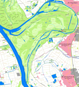
The Kühkopf is an island formed by the Upper Rhine and one of its oxbow lakes in the Hessian Ried . It belongs to the city of Riedstadt (northern part) and the municipality of Stockstadt am Rhein (southern part).
description

Today's Kühkopf was originally an inland peninsula near Guntersblum ( Rhineland-Palatinate ), with east, north and south offshore Rhine islands.
In the course of straightening the Rhine (1828/1829), a straightening penetration was made west of the peninsula and the area was completely separated from the mainland on the left bank of the Rhine, making the peninsula a river island . The Rhine islands that were formerly off the peninsula have over the course of time connected to the Kühkopf through siltation, and the former main course of the Rhine became an old Rhine arch, the Stockstadt-Erfelder Altrhein .
The almost undeveloped Kühkopf today forms the " Kühkopf-Knoblochsaue " nature reserve together with the Knoblochsaue to the north and some smaller islands in the Old Rhine . The Kühkopf alone accounts for around 1,700 hectares of the 2,440 hectare nature reserve . The island can be reached via two bridges.
history
In the War of the Austrian Succession , a bridge was to be built from the offshore Rhine island to the western bank. During a related exploration of the water depth on June 25, 1744, the Hungarian equestrian general Johann Daniel von Menzel was fatally hit by a French sniper.
literature
- Sebastian Pfeifer: The Kühkopf-Knoblochsaue nature reserve, 4th edition 1979, Frankfurt am Main.
- Franz Jahn: A hike through the nature and bird sanctuary "Kühkopf", with lots of drawings and a map.
Picture gallery
Industrial monument oil production on the Kühkopf


