
Kühkopf-Knoblochsaue
Coordinates: 49 ° 49 '25.9 " N , 8 ° 26" 56.7 " E


The Kühkopf-Knoblochsaue European reserve in the Groß-Gerau district is the largest nature reserve in Hesse . It is part of the Hessian Ried between the Rhine and Bergstrasse . It is also designated as the largest contiguous flood area along the Hessian bank of the Rhine and thus serves to protect against flooding .
Description / history

The area around the Rheinschleife at the Kühkopf was hunting ground for the nobility until the beginning of the 17th century. At the same time the first farm estates were created. In 1617 the Metternich'sche Auhaus was built, which formed the nucleus of the Kälberteicher Hof. The Guntershausen estate emerged from the Gemmingen Auhaus. To the east, south and north were smaller Rhine islands.
In the Knoblochsaue the Swedish column commemorates the crossing of the Rhine by the Swedish King Gustav Adolf on September 7, 1631 during the Thirty Years' War . During the War of the Austrian Succession , a bridge was to be built to the western bank from the Rhine Island (Mulberry Island) off the Kühkopf to the east. During a related exploration of the water depth on June 25, 1744, the Hungarian equestrian general Johann Daniel von Menzel was fatally hit by a French sniper.
The landscape in its current form emerged when parts of the 2,440 hectare area were separated from the west bank during the Rhine regulation by the Grand Ducal Darmstadt hydraulic engineering director Claus Kröncke in 1828/1829 (so-called Rhine breakthrough). As a result, the Kühkopf became an island, encompassed by the new main stream and the loop of the old river course, which has become the Old Rhine Arm as Stockstadt-Erfelder Altrhein . The formerly offshore Rhine island is now connected to the main area by siltation, as are the former islands in the north and south. The Knoblochsaue became a peninsula through the puncture.
Until 1945 the separated area belonged to the Guntersblum and Gimbsheim districts . A ferry service was set up to manage the property of the farmers on the Kühkopf . Since Guntersblum had the greater share of the Kühkopf, it received a carriage ferry; it was the last greed ferry across the Rhine. Gimbsheim maintained a boat at river kilometer 470 as a passenger ferry for the management of the Geyer lying on the Kühkopf .
The special ecological importance was recognized early on and the area was placed under nature protection on March 20, 1952 . It now bears the title “European reserve” and has been additionally protected since 2008 by the fauna-flora-habitat directive of the European Union .
Crude oil was produced on the Kühkopf until 1994 . As a reminder, there is still an old oil feed pump , a so-called “ horse's head ” , at the Guntershausen estate .
nature and landscape
In the protected area, there are both softwood meadows with the gnarled willow trees and black poplars characteristic of this landscape, as well as hardwood meadows with oak, elm and ash.
The extensive marshland in the meadow landscape with grass, reed and hardwood plants offer resting and breeding areas for numerous bird species. The dam breach in April 1983 was intentionally not repaired. Agriculture, which was no longer protected from floods, was given up and the areas left to develop naturally. They are exposed to the regular flooding of the Rhine. However, the level of the Rhine continues to drop by up to 1 cm per year, while every flood deposits silt and the areas slowly dry out.
The symbol of the cow head is the black kite . Red and wild boar, foxes, frogs and common toads are common in the protected area.
In spring, large parts of the forest floor are covered by wild garlic .
In winter, the penetration of many trees in the edge areas of the alluvial forest with mistletoe nests can be clearly seen.
The area is part of the Bergstrasse-Odenwald Geo-Nature Park . A project for renaturation of the river valley meadows has been running since 2004 . With the abandonment of agriculture in 1983, they did not resettle on their own as the conservationists expected; rather, the transfer of ripe seeds from the characteristic plants helps here.
Infrastructure, bike and hiking trails
The inland island Kühkopf can be reached over the pedestrian bridge in Erfelden ( Riedstadt ) or over the bridge in Stockstadt am Rhein . From there, the Guntershausen estate and the associated information center can also be reached. From the left bank of the Rhine, the island could be reached by passenger ferry from Guntersblum until 2012. The ferry service has been discontinued since 2013.
An approximately 60 km long network of cycle and hiking trails with historical and natural history information boards opens up the Kühkopf Inner Island and the Knoblochsaue. One circular route is dedicated to the writer Elisabeth Langgässer ; in her novel Gang durch das Ried , published in 1936, she describes this landscape that she knew from her time as a teacher in Griesheim. Both areas have a "forester's house"; Only the one on Kühkopf Island is managed for the public.
In the Knoblochsaue, the network of cycling and hiking trails also includes the adjacent reed landscapes outside the nature reserve as far as Leeheim and the Bensheimerhof (historic farm estate). The border is behind the accessible Rhine winter dike . When New Year hole and brother holes (separate nature reserve, 16 ha) is, to scour the flooding of the dike have left. Other neighboring nature reserves are the Michelried and the Riedwiesen von Wächterstadt .

A silted up arm of the Rhine
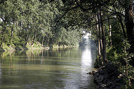
The Old Rhine, immediately behind the outflow of the Rhine (southern connection with the Rhine = tributary). The Kühkopf is on the left.

The tributary of the Old Rhine from the Rhine. In the background the Rhine and to the right the island of Kühkopf

The old Rhine near Stockstadt am Rhein. The nature reserve to the left of the river.
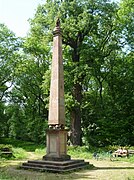
Sweden column

Oil feed pump at the Guntershausen estate

Kühkopf and Knoblochsaue on a map from 1738


literature
- Gerold Bielohlawek-Hübel (Ed.): How the Kühkopf came about . Forum, Riedstadt-Goddelau 2004, ISBN 3-937316-03-5 .
- Gerold Bielohlawek-Hübel (Ed.): Kühkopf-Knoblochsaue experience . A companion through the meadow landscape of Kühkopf and Knoblochsaue . Forum, Riedstadt-Goddelau 2003, ISBN 3-937316-00-0 .
- Hans Pehle: The "Rhine crossing" of the Swedish king Gustav II Adolf . An event in the Thirty Years War . Forum, Riedstadt-Goddelau 2000, ISBN 3-9806490-8-3 .
- Gunter Schöcker: The Kühkopf-Knoblochsaue nature reserve. Monument Preservation & Cultural History. Edited by the State Office for Monument Preservation Hessen. 3-2015, pp. 3-8 .
Web links
- http://www.schatzinsel-kuehkopf.hessen.de
- Homepage kuehkopf.de
- Förderverein Hofgut Guntershausen e. V.
- Kühkopf-Knoblochsaue in the portal for Groß-Gerau and Rhein-Main
- Information flyer for the Kühkopf-Knoblochsaue nature reserve
- Aerial video of Kühkopf-Knoblochsaue, from Hessischer Rundfunk
Individual evidence
- ↑ Gunter Schöker: The Kühkopf-Knoblochsaue nature reserve. In: Monument Preservation & Cultural History. Edited by the State Office for Monument Preservation Hessen. 3-2015, pp. 3-8.
- ↑ Gimbsheim and the Rhine
- ↑ Commemorative publication “50 years of the Kühkopf Knoblochsaue nature reserve” by the Darmstadt Regional Council from 2002 , PDF file 4.97 MB
- ^ Ordinance of the Darmstadt regional council on the nature reserve of April 17, 1998 (StAnz. P. 1299) PDF file 3.01 MB
- ↑ Management plan for the FFH area 6116-350 / 6116-450 Kühkopf-Knoblochsaue PDF file 11.7 MB