
Groß-Gerau district
| coat of arms | Germany map |
|---|---|

|

Coordinates: 49 ° 55 ' N , 8 ° 29' E |
| Basic data | |
| State : | Hesse |
| Administrative region : | Darmstadt |
| Administrative headquarters : | Gross-Gerau |
| Area : | 453.04 km 2 |
| Residents: | 275,726 (Dec. 31, 2019) |
| Population density : | 609 inhabitants per km 2 |
| License plate : | GG |
| Circle key : | 06 4 33 |
| NUTS : | DE717 |
| Circle structure: | 14 municipalities |
| Address of the district administration: |
Wilhelm-Seipp-Strasse 4 64521 Gross-Gerau |
| Website : | |
| District Administrator : | Thomas Will ( SPD ) |
| Location of the Groß-Gerau district in Hesse | |
  |
|
The district of Groß-Gerau is a regional authority in the southern Hessian administrative district of Darmstadt .
geography
location
The district is located in the upper Rhine valley . The Main forms the northern, the Rhine the western border. A large part of the district is in the Hessian Ried .
The highest point in the district is the Oberwaldberg at 145 m , a disused garbage dump near Mörfelden . The lowest point is the Mainspitze at 82 m, where the Main flows into the Rhine.
Neighboring areas
The district borders in a clockwise direction in the northwest on the independent city of Wiesbaden , the Main-Taunus district , the independent city of Frankfurt am Main , the districts of Offenbach , Darmstadt-Dieburg and Bergstrasse (all in Hesse). In the west, the Rhine forms the natural border. To the left of the Rhine are the Rhineland-Palatinate districts of Alzey-Worms and Mainz-Bingen and the independent city of Mainz .
Land use
The district area covers a total of 45,305 hectares, of which the following hectares are:
| Type of use | 2011 | 2015 | |
|---|---|---|---|
| Building and open space | 5,473 | 5,593 | |
| from that | Living | 2,950 | 2,969 |
| Business | 894 | 985 | |
| Operating area | 577 | 561 | |
| from that | Mining land | 165 | 145 |
| Recreation area | 701 | 752 | |
| from that | Green area | 354 | 399 |
| traffic area | 3,564 | 3,827 | |
| Agricultural area | 21,032 | 20,726 | |
| from that | moor | 2 | 2 |
| pagan | 1 | 1 | |
| Forest area | 11,023 | 10,893 | |
| Water surface | 2,321 | 2,359 | |
| Other use | 616 | 594 | |
The agricultural area is a type of use with 46.5 percent, an above-average share in Hessen. The forest area, on the other hand, is well below average at 24.7 and also very unevenly distributed. The forests are concentrated in the northeast of the district in the area north of Groß-Gerau and east of Rüsselsheim am Main. The proportion of water area is remarkable at 5.1 percent and, at over 23 square kilometers, it is twice the area of the Edersee . This wealth of water is due to the border rivers of the district. From the Rhine there are 38 river kilometers and from the Main 22 river kilometers each to the middle of the river to the district area; Added to this are the water areas of the arms of the Old Rhine at the Kühkopf-Knoblochsaue European reserve and at Ginsheim, as well as a number of flooded gravel mining areas . They “settlement and traffic areas” (consisting of building and open space, operating area (excluding mining land), recreational areas and traffic areas) make up approx. 22% of the total area.
history

The current district area belonged to Hessen-Darmstadt , the later Grand Duchy of Hessen, very early on . It was divided into the offices of Dornberg , Rüsselsheim and Kelsterbach . In 1821 the Dornberg District District was established within the Starkenburg Province . Since 1832 this administrative district has been called the Groß-Gerau district , which has barely changed its borders in the course of history and also survived the district reform of the early 1970s almost unchanged.
Grand Duchy of Hesse
Together with the districts of Bensheim , Darmstadt , Dieburg , Erbach , Heppenheim and Offenbach , and at times with the districts of Lindenfels , Neustadt and Wimpfen , the district of Groß-Gerau formed the province of Starkenburg from 1832 , which in turn formed the Grand Duchy together with the provinces of Upper Hesse and Rheinhessen Hesse represented.
After the proclamation of the constitution of the Grand Duchy of Hesse on December 17, 1820, a comprehensive administrative reform followed on July 14, 1821 . Instead of the offices, districts were now set up. These were the forerunners of the circles.
After a further restructuring announced on August 20, 1832, the Groß-Gerau district was created from the Dornberg district and parts of the Langen district. In 1837 the seat of the district council was moved from Dornberg to Groß-Gerau. On July 31, 1848, the two districts of Groß-Gerau and Darmstadt as well as parts of the Offenbach district were then merged to form the Darmstadt administrative district. However, this administrative reform only lasted four years, because on May 12, 1852 the merger was lifted again. A newly delimited district of Groß-Gerau was created from parts of the district court districts of Gernsheim, Groß-Gerau and Langen.
In the course of the reform of the district constitution in 1874 in the Grand Duchy of Hesse based on the Prussian model, there was a new district division, within the framework of which the two communities Gernsheim and Klein-Rohrheim moved from the Bensheim district to the Groß-Gerau district. The division of the Starkenburg province into the districts of Bensheim, Darmstadt, Dieburg, Erbach, Groß-Gerau, Heppenheim and Offenbach, which was created at that time, lasted for more than six decades.
People's State of Hesse
After the November Revolution of 1918, the Grand Duchy was transformed into a democratic republic, the People's State of Hesse . This designation was retained even after the abolition of democracy when the National Socialists came to power in 1933.
On January 1, 1930, the communities of Bischofsheim and Ginsheim-Gustavsburg and the Ginsheimer Rheinauen district left the Groß-Gerau district and were incorporated into the city of Mainz in the Mainz district of the Rheinhessen province.
After the dissolution of the provincial and district assemblies in the People's State of Hesse in 1936 and the dissolution of the three provinces of Starkenburg, Upper Hesse and Rheinhessen in 1937, the year 1938 brought a review of the district boundaries. On November 1, 1938, a decisive regional reform was carried out in Hesse. One district was dissolved in each of the three Hessian provinces of Starkenburg, Rheinhessen and Upper Hesse. In Starkenburg, the Bensheim district was affected. This was largely added to the Heppenheim district, which also became the legal successor to the Bensheim district. The new administrative unit was renamed the Bergstrasse district . The Groß-Gerau district was renamed the Gerau district . At the same time, the cities of Darmstadt, Gießen, Mainz, Offenbach and Worms became independent as urban districts .
State of Hesse

When today's State of Hesse was founded in the American occupation zone at the end of 1945 , the districts of the predecessor states (the People's State and the Prussian Province of Hesse-Nassau ) remained unchanged. However, the city of Mainz and the municipality of Guntersblum were divided by the zone boundary running in the Rhine channel. While the core areas on the left bank of the Rhine of both municipalities in the French zone were separated from the Hessian state association, the districts of Mainz on the right bank of the Rhine and Kühkopf on the right bank of the Rhine , which remained with Hesse, had to be reassigned at district level. In this way, Bischofsheim and Ginsheim-Gustavsburg became independent communities in the Groß-Gerau district again after having been part of the city of Mainz for fifteen years. The Kühkopf was for the most part incorporated into the municipality of Stockstadt am Rhein . A smaller part, which was opposite the municipality of Erfelden in the north , was integrated into it.
During the regional reform in Hesse in the 1970s, most of the Hessian districts were combined with neighboring districts to form larger units. As one of the few exceptions, the Groß-Gerau district remained largely unaffected. On the north-eastern border, the district gave an important area to the city of Frankfurt, namely the area of Frankfurt am Main Airport . Its southern half (on which the runways are located, the terminal building was also previously on Frankfurt territory) previously belonged to the Walldorf community .
During the regional reform, the number of municipalities in the district was reduced to 14 through mergers, which, depending on their size, were able to take on some of the tasks previously performed by the district administration themselves.
In 1975 the city of Kelsterbach became a member of the new surrounding association Frankfurt , to which some regional and communal responsibilities within the city region of Frankfurt were transferred. The surrounding area was replaced in 2001 by the planning association for the Frankfurt / Rhine-Main conurbation , to which the entire suburban northern part of the district belongs.
Population development
The development of the population in the Groß-Gerau district, from 1975 on December 31:
|
|
Denomination statistics
According to the 2011 census , 30.2% of the population were Protestant , 21.7% Roman Catholic and almost half 48.1% were non-denominational , belonged to another religious community or did not provide any information. The number of Protestants and Catholics has fallen since then.
politics
District council
The local elections on March 6, 2016 produced the following results, compared to previous local elections:
| Diagram showing the election results and the distribution of seats | |
|---|---|
|
Election of the Groß-Gerau district council in 2016
% 40 30th 20th 10
0
33.8%
24.2%
13.2%
10.1%
5.0%
4.2%
4.0%
3.1%
2.2%
Gains and losses
|
|
| Nominations | % 2016 |
Seats 2016 |
% 2011 |
Seats 2011 |
% 2006 |
Seats 2006 |
% 2001 |
Seats 2001 |
|
|---|---|---|---|---|---|---|---|---|---|
| SPD | Social Democratic Party of Germany | 33.8 | 24 | 36.9 | 26th | 42.6 | 30th | 45.9 | 33 |
| CDU | Christian Democratic Union of Germany | 24.2 | 17th | 30.1 | 21st | 32.0 | 23 | 30.0 | 21st |
| AfD | Alternative for Germany | 13.2 | 10 | - | - | - | - | - | - |
| GREEN | Alliance 90 / The Greens | 10.1 | 7th | 21.5 | 15th | 11.3 | 8th | 11.9 | 8th |
| DIE LINKE.OL | DIE LINKE. Open list | 5.0 | 4th | 4.1 | 3 | 4.6 | 3 | 1.8 | 1 |
| FDP | Free Democratic Party | 4.2 | 3 | 2.7 | 2 | 4.6 | 3 | 4.4 | 3 |
| FREE VOTER Citizens List | FREE VOTERS - Citizen List | 4.0 | 3 | - | - | - | - | - | - |
| FW | Free community of voters in the district of Groß-Gerau | 3.1 | 2 | 2.2 | 2 | - | - | - | - |
| PIRATES | Pirate Party Germany | 1.4 | 1 | - | - | - | - | - | - |
| FBG | Free list of citizens in the district of Groß-Gerau | - | - | 1.3 | 1 | - | - | - | - |
| Animal welfare party | Human Environment Animal Welfare Party | - | - | 1.2 | 1 | - | - | - | - |
| FWG | Free community of voters | - | - | - | - | 4.9 | 4th | 2.0 | 2 |
| REP | The Republicans | - | - | - | - | - | - | 4.0 | 3 |
| total | 100.0 | 71 | 100.0 | 71 | 100.0 | 71 | 100.0 | 71 | |
| Voter turnout in% | 43.1 | 43.6 | 43.7 | 52.3 | |||||
At the beginning of the 2011–2016 electoral period, the SPD, FWG and FDP formed a coalition in the district council and thus provided a majority of 37 mandates. However, this coalition broke up and a red-green coalition was formed.
At the beginning of the 2016–2021 electoral period, the SPD, Greens, Left and Pirates formed a coalition, giving them a majority of 36 seats.
District Committee
The district committee (currently) has ten members and is the administrative authority of the district. The chairman is the full-time district administrator Thomas Will (SPD), his deputy is the full-time first district member Walter Astheimer (Greens), as well as another district member who is to be elected before the upcoming local election; the other eight district members (3 SPD, 2 CDU, one each GRÜ, FWG, FDP) are active on a voluntary basis.
District Administrator
| No. | Surname | Life dates | Political party | Beginning of the term of office | Term expires |
|---|---|---|---|---|---|
| 1 | Anselm Karl Elwert | 1821 | 1832 | ||
| 2 | Ernst Wilhelm Heim | 1832 | 1852 | ||
| 3 | Johann Baptist Werle | 1810-1861 | 1852 | 1861 | |
| 4th | Eduard Ernst App | -1862 | 1861 | 1862 | |
| 5 | Karl Boekmann | 1862 | 1877 | ||
| 6th | Wilhelm von Schenk zu Schweinsberg | 1877 | 1885 | ||
| 7th | Erwin Löw from and to Steinfurth | 1885 | 1900 | ||
| 8th | Karl Bichmann | 1900 | 1905 | ||
| 9 | Eduard Wallau | 1905 | 1924 | ||
| 10 | W. Koch | 1924 | 1924 | ||
| 11 | Ernst Werner | 1924 | 1924 | ||
| 12 | Ernst Merck | 1925 | 1931 | ||
| 13 | Hermann Usinger | SPD | 1932 | 1933 | |
| 14th | Straub | 1934 | 1934 | ||
| 15th | Schmal and Gutermuth | 1934 | 1935 | ||
| 16 | Alfred Klostermann | 1900-1945 | NSDAP | 1935 | 1939 |
| 17th | Hans Denser | NSDAP | 1940 | 1945 | |
| 18th | WL Grebner | 1945 | 1945 | ||
| 19th | Wilhelm Hammann | 1897-1955 | KPD | 1945 | 1946 |
| 20th | Jean Christoph Harth | 1882-1956 | SPD | 1946 | 1954 |
| 21st | Wilhelm Seipp | 1906-1963 | SPD | 1954 | 1963 |
| 22nd | Alfred Schmidt | 1905-1975 | SPD | 1964 | 1970 |
| 23 | Willi Blodt | * 1929 | SPD | 1970 | 1992 |
| 24 | Enno Siehr | * 1947 | SPD | 1992 | 2010 |
| 25th | Thomas Will | * 1959 | SPD | 2010 | in office |
District Administrator Enno Siehr , who was in office from 1992 to 2010, was re-elected in the first ballot on February 8, 1998 with 59.2 percent and on February 8, 2004 with 56.0 percent.
After 18 years in office, Siehr retired in 2010. In the district election on February 7, 2010, Thomas Will (SPD), Ursula Kraft (CDU) and Gerd Schulmeyer (left) competed against each other. Thomas Will won the election with around 59 percent of the votes in the first ballot.
Coat of arms, flag and banner

Hoist flag

Banner flag

|
|
Blazon : “Split: at the front divided nine times by red and silver, at the back two black bars in silver; in the middle of the shield a blue heart shield with three (2: 1 set) silver diamonds " |
|
Justification for the coat of arms: The red and silver stripes were taken from the Hessian coat of arms, the black bars stand for the county of Isenburg , to which the Kelsterbach office belonged until 1600, and the heart shield symbolizes the dynasty of Dornberg and their Katzenelnbogen successors who ruled the area before it became Hessian in 1479.
The coat of arms was awarded on January 25, 1967. |
Economy and Transport
In the future atlas 2016 , the district of Groß-Gerau was ranked 58th out of 402 districts and independent cities in Germany, making it one of the regions with "high future prospects". In the 2019 edition, it was ranked 16th out of 401, making it one of the regions with “very good future prospects”.
railroad
The Riedbahn , the Rhein-Main-Bahn and the Mainbahn run through the district . Local transport is integrated into the Rhein-Main transport association . In this respect, the S-Bahn lines S7 , S8 and S9 with their stops, as well as the other regional stops, are of great importance for the district. There are stops and train stations in Biebesheim am Rhein, Bischofsheim ( Mainz-Bischofsheim train station ), Büttelborn (Klein-Gerau train station), Gernsheim, Ginsheim-Gustavsburg ( Mainz-Gustavsburg train station ), Groß-Gerau (with Groß-Gerau , Groß-Gerau Dornberg and Dornheim), Kelsterbach, Mörfelden-Walldorf (with the train stations Mörfelden and Walldorf ), Nauheim , Raunheim , Riedstadt (with Riedstadt-Wolfskehlen and Riedstadt-Goddelau ), Rüsselheim am Main (with train station Rüsselsheim and Rüsselsheim-Opelwerk) and Stockstadt am Rhine.
Street
The federal highways 67 ( Mannheim - Darmstadt - Mönchhof -Dreieck) and 60 ( Rüsselsheim - Bingen am Rhein ), as well as a few kilometers of the A 3 ( Frankfurter Kreuz - Wiesbadener Kreuz ), the A 5 ( Langen / Mörfelden junction ) and the A 671 ( Mainspitz-Dreieck - Wiesbaden ). In addition, several federal, state and district roads open up the district, including the B 42 (and its old route, today L 3482), B 44 and B 486 .
Air traffic
Furthermore, the Frankfurt am Main airport , which is directly adjacent to the district , contributes to the international connection of the district.
shipping
The district is bounded in the west by the Rhine, which is of great importance for inland navigation.
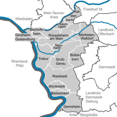
cities and communes
The district town is the eponymous city of Groß-Gerau . The most populous city in the district is Rüsselsheim am Main with more than 65,000 inhabitants . The youngest town in the Groß-Gerau district is Ginsheim-Gustavsburg , which was promoted to town on April 29, 2013 .

(Residents on December 31, 2019)
|
|
Former parishes
The following list contains all former municipalities in the Groß-Gerau district and the dates of their incorporations:
| local community | incorporated after | Date of incorporation |
annotation |
|---|---|---|---|
| Allmendfeld | Gernsheim | December 31, 1971 | Founded on October 31, 1937 |
| Astheim | Trebur | January 1, 1977 | |
| Bauschheim | Ruesselsheim | May 1, 1970 | |
| Berkach | Gross-Gerau | December 31, 1971 | |
| Crumstadt | Riedstadt | January 1, 1977 | |
| Dornberg | Gross-Gerau | April 1, 1939 | |
| Dornheim | Gross-Gerau | January 1, 1977 | |
| Erfelden | Riedstadt | January 1, 1977 | |
| Geinsheim | Trebur | January 1, 1977 | |
| Goddelau | Goddelau wolf throats | July 1, 1973 | |
| Goddelau wolf throats | Riedstadt | January 1, 1977 | Founded on July 1, 1973 |
| Hassloch | Ruesselsheim | April 1, 1951 | |
| Hessenaue | Trebur | January 1, 1977 | Founded on October 1st, 1951 |
| Klein-Gerau | Büttelborn | January 1, 1977 | |
| Klein-Rohrheim | Gernsheim | December 31, 1971 | |
| Royal cities | Ruesselsheim | July 1, 1956 | |
| Leeheim | Riedstadt | January 1, 1977 | |
| Moerfelden | Moerfelden-Walldorf | January 1, 1977 | |
| Walldorf | Moerfelden-Walldorf | January 1, 1977 | |
| Waller cities | Gross-Gerau | January 1, 1977 | |
| Wolf throats | Goddelau wolf throats | July 1, 1973 | |
| Worfelden | Büttelborn | January 1, 1977 |
License Plate
On July 1, 1956, the district was assigned the distinguishing mark GG when the vehicle registration number that is still valid today was introduced . It is still issued today.
Web links
- Website of the district of Groß-Gerau
- Groß-Gerau district. Historical local dictionary. In: Landesgeschichtliches Informationssystem Hessen (LAGIS).
- Literature from and about Groß-Gerau district in the catalog of the German National Library
- Link catalog on the subject of the Groß-Gerau district at curlie.org (formerly DMOZ )
Individual evidence
- ↑ Hessian State Statistical Office: Population status on December 31, 2019 (districts and urban districts as well as municipalities, population figures based on the 2011 census) ( help ).
- ↑ Portrait of a circle. Facts and figures; Geography. In: website. Groß-Gerau district, accessed April 2019 .
- ↑ Hessisches Statistisches Informationssystem In: Statistics.Hessen.
- ^ Grand Ducal Hessian Government Gazette. 1832, p. 562 ( digital.staatsbibliothek-berlin.de ).
- ↑ Announcement, the official seat of the Grand Heart. District council of the Großgerau district on November 6, 1837. In: Großherzoglich Hessisches Regierungsblatt no. 43 of November 17, 1837, p. 462.
- ^ Grand Ducal Hessian Government Gazette . 1852, No. 30 ( reader.digitale-sammlungen.de ).
- ^ Grand Ducal Hessian Government Gazette . No. 28 . Darmstadt June 12, 1874, p. 247 ( digital.staatsbibliothek-berlin.de ).
- ^ Law on the change of the existing borders for the provinces of Starkenburg and Rheinhessen as well as the districts of Groß-Gerau and Mainz of December 10, 1929 . In: Hessisches Gesamtministerium (Hrsg.): Hessisches Regierungsblatt. 1929 No. 18 , p. 193 ( online at the information system of the Hessian state parliament [PDF; 1.5 MB ]).
- ^ Michael Rademacher: German administrative history from the unification of the empire in 1871 to the reunification in 1990. State of Hesse - administrative structure. (Online material for the dissertation, Osnabrück 2006).
- ^ Philipp AF Walther: The Grand Duchy of Hesse by history, country, people, state and locality. 1854, accessed March 2, 2016 .
- ^ A b Michael Rademacher: German administrative history from the unification of the empire in 1871 to the reunification in 1990. Groß-Gerau district. (Online material for the dissertation, Osnabrück 2006).
- ↑ Hessisches Statistisches Informationssystem In: Hessisches Statistisches Landesamt
- ↑ District of Groß-Gerau Religion , 2011 census
- ^ Hessian State Statistical Office: Results of the district elections of 2016 and 2011
- ^ Hessian State Statistical Office: Results of the district elections of 2011 and 2006
- ^ Hessian State Statistical Office: Results of the district elections of 2006 and 2001
- ^ Hessian State Statistical Office: Results of the district elections of 2001 and 1997
- ↑ The ALFA and the Forum Neuer Kreis (FNK) won no seat in 2016, but each won 0.4% of the votes.
- ^ Coalition agreement for the Groß-Gerau district 2016–2021 (PDF).
- ↑ The district administrators of the Groß-Gerau district - an impressive gallery of ancestors - on the district's anniversary page ( memento from January 18, 2008 in the Internet Archive )
- ^ Hessian State Statistical Office: District election in the district of Groß-Gerau
- ^ Approval of a coat of arms and a flag for the district of Groß-Gerau, administrative district of Darmstadt from January 25, 1967 . In: The Hessian Minister of the Interior (ed.): State Gazette for the State of Hesse. 1967 No. 7 , p. 224 , point 152 ( online at the information system of the Hessian state parliament [PDF; 3.0 MB ]).
- ↑ Future Atlas 2016. In: Handelsblatt . 2016, accessed April 24, 2019 .
- ↑ PROGNOS future atlas. Handelsblatt, accessed on December 10, 2019 .
- ↑ Hessian State Statistical Office: Population status on December 31, 2019 (districts and urban districts as well as municipalities, population figures based on the 2011 census) ( help ).
- ↑ Municipal directory 1900: Groß-Gerau district

Province of Upper Hesse : Alsfeld | Büdingen | Friedberg | Casting | Lauterbach | Bulkheads |
Delivered to Prussia in 1866: Biedenkopf | Vöhl |
Dissolved in 1874: Grünberg | Vilbel | Nidda
Province of Rheinhessen : Alzey | Bingen | Mainz | Oppenheim | Worms
Starkenburg Province : Bensheim | Darmstadt | Dieburg | Erbach | Groß – Gerau | Heppenheim | Offenbach |
Dissolved in 1874: Lindenfels | Neustadt | Wimpfen

Province of Upper Hesse : Alsfeld | Büdingen | Friedberg | Casting | Lauterbach |
Newly founded in 1938: Stadtkreis Gießen
Disbanded in 1938: Schotten
Province of Rheinhessen : Alzey | Bingen | Mainz | Worms
Newly founded in 1938: Stadtkreis Mainz | Worms district
Disbanded in 1938: Oppenheim
Starkenburg Province : Darmstadt | Dieburg | Erbach | Groß – Gerau | Offenbach |
Newly founded in 1938: Darmstadt district | Offenbach am Main district | Bergstrasse district
Disbanded in 1938: Bensheim | Heppenheim
Counties: Bergstrasse | Darmstadt-Dieburg | Fulda | Casting | Gross-Gerau | Hersfeld-Rotenburg | Hochtaunuskreis | Kassel (Country) | Lahn-Dill-Kreis | Limburg-Weilburg | Main-Kinzig-Kreis | Main-Taunus-Kreis | Marburg-Biedenkopf | Odenwaldkreis | Offenbach (State) | Rheingau-Taunus-Kreis | Schwalm-Eder district | Vogelsbergkreis | Waldeck-Frankenberg | Werra-Meißner district | Wetteraukreis
Independent cities: Darmstadt | Frankfurt am Main | Kassel | Offenbach am Main | Wiesbaden