
Wetteraukreis
| coat of arms | Germany map |
|---|---|

|

Coordinates: 50 ° 20 ' N , 8 ° 45' E |
| Basic data | |
| Existing period: | 1972– |
| State : | Hesse |
| Administrative region : | Darmstadt |
| Administrative headquarters : | Friedberg (Hesse) |
| Area : | 1,100.69 km 2 |
| Residents: | 308,339 (Dec. 31, 2019) |
| Population density : | 280 inhabitants per km 2 |
| License plate : | FB, BÜD |
| Circle key : | 06 4 40 |
| NUTS : | DE71E |
| Circle structure: | 25 municipalities |
| Address of the district administration: |
Europaplatz 61169 Friedberg (Hesse) |
| Website : | |
| District Administrator : | Jan Weckler ( CDU ) |
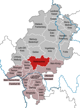
| Location of the Wetterau district in Hesse | |
  |
|
The Wetteraukreis is a district that was created in 1972 in the Darmstadt administrative district in Hesse . The district town is Friedberg (Hessen) .
geography
location
The district is named after the Wetterau landscape north of Frankfurt am Main . It is one of the most productive arable landscapes in Hesse and is named after the Wetter river . In the west, the foothills of the Taunus , eastern Hintertaunus , protrude into the district area. There are numerous mineral and thermal springs here ( Bad Nauheim , Bad Vilbel , Rosbach vor der Höhe ). In the east of the district, the Ronneburg hill country leads to the foothills of the Vogelsberg and the Spessart .
Neighboring areas
The Wetteraukreis borders in a clockwise direction in the north, beginning with the districts of Gießen , Vogelsbergkreis , Main-Kinzig-Kreis , the independent city of Frankfurt am Main and the Hochtaunuskreis and the Lahn-Dill-Kreis .
history
In the course of history, the district was split up into numerous dominions. The most important of these were the Landgraves of Hesse (later both the Hessian parts of Hesse-Darmstadt and Hesse-Kassel ), the Counts of Solms and Ysenburg , Kurmainz , the Burgraviate Friedberg and the Free Imperial City of Friedberg. Since the 19th century at the latest, today's district area has belonged to the Grand Duchy of Hesse , which formed the two districts of Friedberg and Büdingen within the province of Upper Hesse .
In the course of the regional reform in Hesse , a new district called Wetteraukreis was formed on August 1, 1972 , the district town of which was the city of Friedberg (Hesse). The new district was composed of
- the area of the dissolved district of Büdingen without
- the city of Schotten , which became part of the new Vogelsberg district
- the community Altwiedermus , which was incorporated into Ronneburg in what was then the district of Hanau
- the communities Hain-Gründau and middle-Gründau that are part of the community Gruendau in the former district Gelnhausen were
- the area of the dissolved district Friedberg without
- the municipality of Burgholzhausen vor der Höhe , which is part of the city of Friedrichsdorf ,
- and the municipality of Ober-Erlenbach , which was incorporated into the town of Bad Homburg vor der Höhe - both in the new Hochtaunus district
- the communities Harheim , Nieder-Erlenbach and Nieder-Eschbach , in an administrative district in Frankfurt were incorporated
- the community Wolferborn from the district of Gelnhausen, which was incorporated into the city of Büdingen .
Population development
| year | Residents | source |
|---|---|---|
| 1972 | 242,000 | |
| 1980 | 251,900 | |
| 1990 | 263,900 | |
| 2000 | 294.260 | |
| 2010 | 298.195 | |
| 2015 | 298,398 |
politics
District council
The local elections on March 6, 2016 produced the following results, compared to previous local elections:
| Diagram showing the election results and the distribution of seats | |
|---|---|
|
District election in the Wetterau district 2016
% 40 30th 20th 10
0
30.5
28.0
12.2
9.0
7.6
5.7
3.3
2.2
0.9
0.6
Gains and losses
|
|

| Nominations | % 2016 |
Seats 2016 |
% 2011 |
Seats 2011 |
% 2006 |
Seats 2006 |
% 2001 |
Seats 2001 |
|
|---|---|---|---|---|---|---|---|---|---|
| CDU | Christian Democratic Union of Germany | 30.5 | 25th | 35.6 | 29 | 40.0 | 32 | 41.0 | 33 |
| SPD | Social Democratic Party of Germany | 28.0 | 23 | 31.8 | 26th | 35.4 | 29 | 38.8 | 32 |
| AfD | Alternative for Germany | 12.2 | 10 | - | - | - | - | - | - |
| GREEN | Alliance 90 / The Greens | 9.0 | 7th | 15.8 | 13 | 7.2 | 6th | 7.5 | 6th |
| FWG / UWG | Free community of voters / Independent community of voters Wetterau | 7.6 | 6th | 6.4 | 5 | 5.8 | 5 | 4.9 | 4th |
| FDP | Free Democratic Party | 5.7 | 4th | 3.6 | 3 | 5.0 | 4th | 4.0 | 3 |
| THE LEFT. | THE LEFT. (2006: DIE LINKE. WASG ) | 3.3 | 3 | 2.4 | 2 | 3.0 | 2 | - | - |
| NPD | National Democratic Party of Germany | 2.2 | 2 | 2.5 | 2 | 3.6 | 3 | 3.3 | 3 |
| PIRATES | Pirate Party Germany | 0.9 | 1 | 1.9 | 1 | - | - | - | - |
| total | 100.0 | 81 | 100.0 | 81 | 100.0 | 81 | 100.0 | 81 | |
| Voter turnout in% | 51.7 | 49.7 | 48.6 | 53.5 | |||||
District administrators of the Wetterau district
| District Administrator | Term of office |
|---|---|
| Erich Milius (SPD) | 1952-1972 |
| Arno Kuhn (SPD) | 1973-1979 |
| Helmut Münch (CDU) | 1979-1983 |
| Sigurd Beyer (CDU) | 1984-1985 |
| Herbert Rüfer (SPD) | 1985-1992 |
| Rolf Gnadl (SPD) | 1992-2007 |
| Joachim Arnold (SPD) | 2008-2018 |
| Jan Weckler (CDU) | since 2018 |
The last district election took place on March 4, 2018. In the first ballot, Jan Weckler (CDU) received 44.3% of the vote, the SPD candidate Stephanie Becker-Bösch received 33.3% of the vote. Thomas Zebunke (Greens) and Daniel Libertus (FDP) received 14.8% and 7.5% of the vote, respectively. The turnout was 31.7%. Since none of the candidates achieved an absolute majority in the first ballot, a run-off election between Jan Weckler and Stephanie Becker-Bösch took place on March 18, 2018, in which Jan Weckler was elected district administrator with 57% of the votes. The turnout was 23.1%.
Coat of arms, flag and banner

Hoist flag

Banner flag

|
|
Blazon : “Divided by a blue wavy bar; The black, red-armored double- headed eagle growing in gold above, two red bars below in silver. " |
| Reasons for the coat of arms: The imperial eagle stands for the imperial state of Wetterau, which existed until the Middle Ages, or for the formerly free imperial city of Friedberg. The red bars are the symbol of the Counts of Isenburg-Büdingen, who ruled the eastern district area, and the blue wave bar symbolizes the river Wetter and is therefore a "talking" symbol . The coat of arms was awarded on July 2, 1975. |
Economy and Transport
In the future atlas 2016 , the Wetteraukreis ranked 151st out of 402 districts, municipal associations and independent cities in Germany, making it one of the regions with a “balanced risk-opportunity mix”. In the 2019 edition, it was ranked 94th out of 401.
traffic
The fertile plain of the Wetterau between Taunus and Vogelsberg has always been an important thoroughfare from north to south. The Main-Weser-Bahn was the first to take this route between Kassel and Frankfurt. It was opened in 1850 from Frankfurt via Friedberg to Butzbach and in 1851 on to Lang-Göns. At that time, the district was part of Hessen-Darmstadt with the exception of Bad Nauheim in Hesse, which was only added in 1866.
On the edge of the Vogelsberg, another north-south line from Gießen via Nidda-Büdingen to Gelnhausen was built in 1870 by the initially private Upper Hessian Railway Company , which was then incorporated into the Hessian State Railway in 1876 .
To bypass the Frankfurt area, the Prussian State Railroad built a direct connection from Hanau to Friedberg , which was completed in 1881 with the section from Heldenbergen-Windecken.
The Hessian State Railway began to develop the Vogelsberg in 1888 with two branch lines from Nidda to Schotten and from Stockheim to Gedern , the latter of which was extended in 1906 to Grebenhain-Crainfeld and thus developed into a cross connection to Lauterbach.
The Friedberg station , which is now served by Intercity and ICE trains, developed into the most important railway junction . The three existing rail routes from Friedberg to Frankfurt, Gießen and Hanau were added: in 1897 the branch lines to Hungen and Nidda, which use the same route to Beienheim, and in 1901 the main line to Friedrichsdorf built as part of the Nauheim – Homburg – Wiesbaden railway.
In addition to Nidda, Stockheim is also a hub; the Niddertal Railway to Heldenbergen-Windecken has started here since 1905 and continues to Bad Vilbel on the Main-Weser Railway in 1907 .
Finally, the private Butzbach-Licher Eisenbahn AG , a subsidiary of Lenz & Co GmbH , completed the rail network with the railways that originated from Butzbach:
- 1904: Butzbach West - Butzbach East - Griedel - Lich
- 1910: Griedel - Rockenberg - Bad Nauheim
- 1910: Butzbach Ost - Oberkleen.
The federal highways 5 (Frankfurt-Kassel) and 45 (Dortmund-Aschaffenburg) run through the district . In addition, several federal and district roads open up the district area, including the B 3 , B 275 , B 455 , B 457 and B 521 .
Around 225,000 vehicles were registered in the Wetterau district at the end of 2010, including 169,000 cars, 8,700 trucks and 15,000 motorcycles.
Local public transport in the district is operated by Verkehrsgesellschaft Oberhessen (VGO) as part of the Rhein-Main-Verkehrsverbund (RMV).
Press
The most important local newspaper is the Wetterauer Zeitung (Friedberg / Bad Nauheim), in the Bad Vilbel area the Frankfurter Neue Presse , in the eastern district the Kreis-Anzeiger (Nidda), in the northwest the Butzbacher Zeitung . The local editions of the Frankfurter Rundschau are also widely read in the Wetterau district.
Communities


(Residents on December 31, 2019)
|
|
License Plate
On August 1, 1972, the district was assigned the FB distinguishing mark , which had been valid since July 1, 1956 for the Friedberg district in Hesse . It is still issued today.
Until the 1990s, vehicles from the old district of Büdingen received license plates with the letter pairs DA to DZ and LA to LZ and the numbers from 100 to 999.
Since January 2, 2013, the distinctive sign BÜD (Büdingen) has also been available.
literature
- Hans Wolf: The Wetterau - history, communities and landscapes of the Wetteraukreis . Petermann, Bad Nauheim 2002, ISBN 3-9808581-0-3 .
Web links
- Link catalog on the topic of Wetteraukreis at curlie.org (formerly DMOZ )
- Official website of the Wetteraukreis
- Literature by and about Wetteraukreis in the catalog of the German National Library
- Nature pictures from the Wetterau habitat, animals, mushrooms, plants
Individual evidence
- ↑ Hessian State Statistical Office: Population status on December 31, 2019 (districts and urban districts as well as municipalities, population figures based on the 2011 census) ( help ).
- ^ Federal Statistical Office (ed.): Historical municipality directory for the Federal Republic of Germany. Name, border and key number changes in municipalities, counties and administrative districts from May 27, 1970 to December 31, 1982 . W. Kohlhammer, Stuttgart / Mainz 1983, ISBN 3-17-003263-1 , p. 386 .
- ↑ Law on the reorganization of the districts of Büdingen and Friedberg of July 11, 1972 . In: The Hessian Minister of the Interior (ed.): Law and Ordinance Gazette for the State of Hesse . 1972 No. 17 , p. 230-232 , second section; § 18 ( online at the information system of the Hessian state parliament [PDF; 1,2 MB ]).
- ↑ Statistical Yearbook for the Federal Republic of Germany 1974
- ^ A b Michael Rademacher: German administrative history from the unification of the empire in 1871 to the reunification in 1990. Wetteraukreis. (Online material for the dissertation, Osnabrück 2006).
- ↑ Hessian State Statistical Office }
- ↑ Population in the administrative districts on September 30, 2010 and population processes in the 3rd quarter of 2010. Hessian State Statistical Office, archived from the original on May 10, 2011 ; accessed on May 31, 2019 .
- ↑ Population in the administrative districts on June 30, 2015 and change in population in the 2nd quarter of 2015. Hessian State Statistical Office, archived from the original on March 24, 2016 ; accessed on May 31, 2019 .
- ^ Hessian State Statistical Office: Results of the district elections of 2016 and 2011
- ^ Hessian State Statistical Office: Results of the district elections of 2011 and 2006
- ^ Hessian State Statistical Office: Results of the district elections of 2006 and 2001
- ^ Hessian State Statistical Office: Results of the district elections of 2001 and 1997
- ↑ The ALFA, now LKR , did not win a seat in 2016, but won 0.6% of the votes.
- ↑ The WAL won no seat in 2001, but 0.5% of the vote.
- ↑ Result of the district elections in 2018. Wetteraukreis, accessed on April 16, 2018 .
- ^ Result of the runoff election, District Administrator Wetteraukreis 2018. Wetteraukreis, accessed on April 16, 2018 .
- ↑ Zukunftsatlas 2016. Archived from the original ; accessed on March 23, 2018 .
- ↑ PROGNOS future atlas. Handelsblatt, accessed on December 10, 2019 .
- ↑ Hessian State Statistical Office: Population status on December 31, 2019 (districts and urban districts as well as municipalities, population figures based on the 2011 census) ( help ).
Counties: Bergstrasse | Darmstadt-Dieburg | Fulda | Casting | Gross-Gerau | Hersfeld-Rotenburg | Hochtaunuskreis | Kassel (Country) | Lahn-Dill-Kreis | Limburg-Weilburg | Main-Kinzig-Kreis | Main-Taunus-Kreis | Marburg-Biedenkopf | Odenwaldkreis | Offenbach (State) | Rheingau-Taunus-Kreis | Schwalm-Eder district | Vogelsbergkreis | Waldeck-Frankenberg | Werra-Meißner district | Wetteraukreis
Independent cities: Darmstadt | Frankfurt am Main | Kassel | Offenbach am Main | Wiesbaden
Altenstadt | Bad Nauheim | Bad Vilbel | Büdingen | Butzbach | Echzell | Florstadt | Friedberg (Hesse) | Gedern | Glauburg | Hirzenhain | Karben | Kefenrod | Limeshain | Munzenberg | Nidda | Niddatal | Ober-Mörlen | Ortenberg | Ranstadt | Reichelsheim (Wetterau) | Rockenberg | Rosbach v. d. Height | Wölfersheim | Wöllstadt