
Nidda
| coat of arms | Germany map | |
|---|---|---|

|
Coordinates: 50 ° 25 ' N , 9 ° 1' E |
|
| Basic data | ||
| State : | Hesse | |
| Administrative region : | Darmstadt | |
| County : | Wetteraukreis | |
| Height : | 132 m above sea level NHN | |
| Area : | 118.35 km 2 | |
| Residents: | 17,203 (Dec. 31, 2019) | |
| Population density : | 145 inhabitants per km 2 | |
| Postal code : | 63667 | |
| Primaries : | 06043, 06044 (Stornfels), 06046 (Schwickartshausen), 06402 (Unter-Widdersheim) | |
| License plate : | FB, BÜD | |
| Community key : | 06 4 40 016 | |
| LOCODE : | DE NID | |
| City structure: | 18 districts | |
City administration address : |
Wilhelm-Eckhardt-Platz 63667 Nidda |
|
| Website : | ||
| Mayor : | Hans-Peter Seum ( independent ) | |
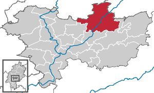
| Location of the city of Nidda in the Wetterau district | ||
  |
||

Nidda is a town in the Hessian Wetteraukreis in the natural area Unterer Vogelsberg . It owes its name to the river Nidda .
geography
Neighboring communities
Nidda borders the city of Laubach ( Gießen district ) in the north, the city of Schotten ( Vogelsbergkreis ) and the municipality of Hirzenhain in the east, the city of Ortenberg and the municipality of Ranstadt in the south, the municipality of Echzell in the south-west and the municipality in the west Wölfersheim (all in the Wetterau district) and the city of Hungen (Gießen district).
City structure
Nidda consists of the districts of Bad Salzhausen , Borsdorf , Eichelsdorf , Fauerbach , Geiß-Nidda , Harb , Kohden , Michelnau , Nidda, Ober-Lais (with Unter-Lais), Ober-Schmitten , Ober-Widdersheim , Schwickartshausen , Stornfels , Ulfa , Unter-Schmitten , Unter-Widdersheim and Wallernhausen .
history


Between 802 and 817 Nidda was first mentioned as Nitaha in the Codex Eberhardi . Later forms of the place name were Nithehe (1187), Nitehe (1206) and Nitehehe (1234).
The noble free Volkold II. , But perhaps also his father Volkold I von Malsburg , whom he followed as Vogt of the imperial abbey of Fulda over their property in the northern Wetterau , built a circular moated castle in Nidda around 1100 , which the Hohenstaufen emperors to secure the passing trade routes served. (Soon after 1604, when Nidda fell to Hessen-Darmstadt , it was torn down and replaced by a Renaissance castle .) Volkold II moved his residence from Bingenheim Castle to Nidda and founded the family of the Counts of Nidda .
In 1187, Count Berthold II of Nidda transferred the parish of Nidda together with considerable property to the Order of St. John , which then set up a commandery in Nidda . The residential and farm buildings of the order then built determined the image of the city in the following centuries. In 1205, Count Ludwig I von Ziegenhain inherited the small county of Nidda , as his mother Mechthild, sister of the last Count of Nidda, Berthold II, who had died without a male heir, had been her brother's sole heir. In 1234, Nidda was first referred to as a city in a document from Count Gottfried IV and Berthold I von Ziegenhain; In 1218 and 1223 the place was still referred to as "villa".
From 1258 to 1311/1333, the counties of Ziegenhain and Nidda were again divided from one another after an inheritance. It was not until 1333 that reunification took place. Count Johann I von Ziegenhain married the daughter Lukardis (Luitgart) of Count Engelbert I from Nidda in 1311 . He died in 1330 and his daughter remained the nominal regent until 1333. In 1333 Johann von Ziegenhain then united both counties in his hand.
After the counts of Ziegenhain and Nidda died out with the death of Johann II in 1450, the county of Nidda came into the possession of the Landgraves of Hesse . Since then, the title “Graf von Nidda” has been part of the family name in the Hesse family. At that time, the county of Nidda included the office of Nidda with the courts of Widdersheim , Rodheim , Ulfa and Wallernhausen , the rule Lißberg , the Fulda Mark with half of the bailiwicks of Echzell , Berstadt , Dauernheim and Bingenheim (with the exception of the local castle ), and the courts Burkhards and Crainfeld . A late Gothic church tower was added to the Romanesque parish church in 1491, which was extensively renovated in 2012, including the roof tower.
In 1821 the offices were dissolved and Nidda became the seat of the district of Nidda and from 1830 of the district of Nidda and from 1848 to 1852 of the administrative district of Nidda .
The statistical-topographical-historical description of the Grand Duchy of Hesse reports on Nidda in 1830:
“Nidda (L. Bez. Gl. N.) city; lies in a swampy area on the Nidda, over which a bridge leads here, as well as on the Chaussee that goes from here to Berstadt, which connects there with the Chaussee that leads from Friedberg to Grünberg. The city that is walled and provided with gates. and 486 Hess. (374 Par.) Feet above the sea, and 7 hours southeast of Giessen, has 303 houses and 1700 inhabitants, who are Protestant apart from 3 Catholics and 40 Jews. Nidda is the seat of the district councilor, one district court and the principal collector. You will find 1 beautiful church, which was built in 1617, 1 churchyard chapel, 1 tower, called the Johanniter Tower, with a beautiful bell, 1 castle, 1 town hall, 2 mills, 1 post office, 1 pharmacy. One of the buildings of the castle is inhabited by the district administrator and the other by the district judge. The castle is surrounded by a wall, which is now used as a garden. The foundations of the Altenburg lie on a mountain nearby. Among the inhabitants there are 114 farmers and 108 who do civil trades, and among the latter there are particularly many linen weavers and hosiery workers, as well as tanners. 4 markets are held annually. In 1809 Nidda was so flooded that many families had to take refuge on the second floor and almost all food was carried away or spoiled. Most residents have their cellars in front of the city leagues, and there are few cellars in the city itself. - Nidda appears several times under the name Nitahe in older Fuldischen documents, but without time determination . The Counts of Nidda, who probably took their seat here in the last half of the 11th century, undoubtedly contributed a lot to the rise of the place. A Johanniter-Ordens-Commende existed here, but its origin is unknown. But already in 1234 this order had a pastor here. Ludwig II., Count von Nidda, sold Niederleisa and Jchelshausen to the order in 1278 for 60 marks. Heilwig, Engelbert's I. Count of Nidda widow, bought the goods of the Johanniter zu Nidda in 1330, whereby and since the annual income was only eight marks, the order ceased here. These goods were donated to the Hersfeld Monastery in the same year. In a document from 1206, Count Ludwig von Ziegenhain also listed his castle men ( Castellani in Nitehe ) and the local mayor. In the period from 1218 to 1223 Nidda is called a villa , and in 1234 an oppidum . In 1323, Johann I, Count of Nidda, was enfeoffed by Emperor Ludwig von Baiern with the castle and town of Nidda and affiliations, presumably for the reason that the Fuld monastery caused difficulties. Johann II., Who had also received the enfeoffment in 1420 from Emperor Siegmund, left Nidda to Landgrave Ludwig I, who received the enfeoffment as early as 1434, from the Abbot Johann of Fuld. On August 3, 1437, the landgrave paid homage to the city that the count had granted him during his lifetime. During the Thirty Years' War, an imperial patrol party of 400–500 men attacked the city, penetrated through the gate because of neglected guards on the part of the citizens, shot the porter and spread out to plunder. But the Hessian captain Blum, who was lying with his company in the castle, with the help of the armed citizens drove out the patrol corps, which deployed several times, but finally had to withdraw, but burned a few houses in the suburbs in revenge. After the French invaded the Upper County of Katzenellenbogen in 1688 and also occupied Darmstadt, the court moved to Nidda, from where it withdrew to Giessen. "
Territorial history and administration
The following list gives an overview of the territories in which Nidda was located or the administrative units to which it was subordinate:
- before 1206: Holy Roman Empire , County Nidda
- from 1206: Holy Roman Empire, Grafschaft Ziegenhain , Amt Nidda , Court Nidda
- 1450–1495: Hereditary dispute between the Landgraviate of Hesse and the Counts of Hohenlohe
- from 1450: Holy Roman Empire , Landgraviate of Hessen , Amt Nidda, Court of Nidda
- from 1567: Holy Roman Empire, Landgraviate Hessen-Marburg , Amt Nidda, Court Nidda
- 1604–1648: Holy Roman Empire, disputed between Landgraviate Hessen-Darmstadt and Landgraviate Hessen-Kassel ( Hessian War )
- from 1604: Holy Roman Empire, Landgraviate Hesse-Darmstadt, Upper Duchy of Hesse , Office Nidda, Court Nidda
- 1787: Holy Roman Empire, Landgraviate of Hesse-Darmstadt, Upper Duchy of Hesse, Office of Nidda and Lißberg, Court of Nidda
- from 1806: Grand Duchy of Hesse , Upper Duchy of Hesse , Office and (since 1803) Court of Nidda
- from 1815: German Confederation , Grand Duchy of Hesse, Province of Upper Hesse , Office of Nidda
- from 1821: German Confederation, Grand Duchy of Hesse, Province of Upper Hesse, District District Nidda (separation between justice ( District Court Nidda ) and administration)
- from 1832: German Confederation, Grand Duchy of Hesse, Province of Upper Hesse, Nidda district
- from 1848: German Confederation, Grand Duchy of Hesse, administrative district of Nidda
- from 1852: German Confederation, Grand Duchy of Hesse, Province of Upper Hesse, Nidda district
- from 1866: North German Confederation , Grand Duchy of Hesse, Province of Upper Hesse, Nidda district
- from 1874: German Empire , Grand Duchy of Hesse, Province of Upper Hesse, District of Büdingen
- from 1918: German Empire, People's State of Hesse , Province of Upper Hesse, District of Büdingen
- from 1938: German Empire, People's State of Hesse , Büdingen district (provinces dissolved in 1937)
- from 1945: American occupation zone , Greater Hesse , Darmstadt administrative region, Büdingen district
- from 1949: Federal Republic of Germany , State of Hesse , Darmstadt administrative district, Büdingen district
- from 1972: Federal Republic of Germany, State of Hesse, Darmstadt district, Wetterau district
Territorial reform
As part of the regional reform in Hesse , the previously independent communities of Borsdorf, Fauerbach bei Nidda, Geiß-Nidda, Harb, Kohden, Michelnau, Ober-Lais, Ober-Schmitten, Ober-Widdersheim, Bad Salzhausen, Stornfels, merged on December 1, 1970 Ulfa, Unter-Schmitten, Wallernhausen and the city of Nidda to form the new city of Nidda. On December 31, 1971 Schwickartshausen was incorporated . Eichelsdorf and Unter-Widdersheim as well as a sub-area of the neighboring town of Hungen with then around 50 inhabitants followed on August 1, 1972 by virtue of state law.
population
Population structure
According to the 2011 census , there were 16,864 residents in Nidda on May 9, 2011. These included 1,020 (6.0%) foreigners, of whom 302 came from outside the EU , 554 from other European countries and 164 from other countries. Of the German residents, 12.9% had a migration background . The inhabitants lived in 7164 households. Of these, 2147 were single households , 2195 were couples without children and 2008 were couples with children, as well as 632 single parents and 182 shared apartments .
Population development
| • 1791: | 1177 inhabitants |
| • 1800: | 1401 inhabitants |
| • 1806: | 1431 inhabitants, 282 houses |
| • 1829: | 1700 inhabitants, 303 houses |
| • 1867: | 1703 inhabitants, 292 inhabited buildings |
| • 1875: | 1759 inhabitants, 294 inhabited buildings |
| Nidda: Population from 1791 to 2015 | ||||
|---|---|---|---|---|
| year | Residents | |||
| 1791 | 1,177 | |||
| 1800 | 1,401 | |||
| 1806 | 1,431 | |||
| 1829 | 1,700 | |||
| 1834 | 1,755 | |||
| 1840 | 1,966 | |||
| 1846 | 1.926 | |||
| 1852 | 1,920 | |||
| 1858 | 1,816 | |||
| 1864 | 1,759 | |||
| 1871 | 1,753 | |||
| 1875 | 1,759 | |||
| 1885 | 1,814 | |||
| 1895 | 1,792 | |||
| 1905 | 2,001 | |||
| 1910 | 2.130 | |||
| 1925 | 2,283 | |||
| 1939 | 2,543 | |||
| 1946 | 4,055 | |||
| 1950 | 4,394 | |||
| 1956 | 4,310 | |||
| 1961 | 4,443 | |||
| 1967 | 4,775 | |||
| 1970 | 4,619 | |||
| 1975 | 16,086 | |||
| 1980 | 16,281 | |||
| 1985 | 16,486 | |||
| 1990 | 17,342 | |||
| 1995 | 18,519 | |||
| 2000 | 18,403 | |||
| 2005 | 18,168 | |||
| 2010 | 17,599 | |||
| 2011 | 16,864 | |||
| 2015 | 17,299 | |||
| Data source: Historical municipality register for Hesse: The population of the municipalities from 1834 to 1967. Wiesbaden: Hessisches Statistisches Landesamt, 1968. Further sources:; from 1975 :; 2011 census From 1972 including the towns incorporated into Hesse as part of the regional reform . | ||||
Religious affiliation
| • 1829: | 1,657 Protestant (= 97.47%), 3 Roman Catholic (= 0.78%), 40 Jewish (= 2.35%) residents |
| • 1961: | 2,943 Protestant (= 72.83%), 798 Roman Catholic (= 24.06%) residents |
| • 2011: | 10,680 Protestant (= 63.7%), 2,360 Catholic (= 14.1%), 210 Orthodox (= 1.2%), 2,360 non-believers (= 3.3%), 2,780 other (= 16.6%) residents |
religion
The population of the city of Nidda is predominantly of Protestant faith.
At the beginning of the 20th century, around 100 Jews lived in Nidda. About half were able to emigrate before the war, the others fell victim to the Nazi regime. The first stumbling blocks were laid in Nidda in February 2014 .
In June 2011 the Ahmadiyya-Muslim-Jamaat opened the Bait-ul-Aman Mosque, which is equipped with a minaret and a dome.
politics
City Council
The local elections on March 6, 2016 produced the following results, compared to previous local elections:
| Parties and constituencies |
% 2016 |
Seats 2016 |
% 2011 |
Seats 2011 |
% 2006 |
Seats 2006 |
% 2001 |
Seats 2001 |
||
|---|---|---|---|---|---|---|---|---|---|---|
| SPD | Social Democratic Party of Germany | 31.3 | 12 | 36.8 | 14th | 40.3 | 15th | 41.5 | 15th | |
| CDU | Christian Democratic Union of Germany | 27.8 | 10 | 30.0 | 11 | 46.0 | 17th | 45.7 | 17th | |
| BL | Citizen List Nidda | 30.8 | 12 | 16.6 | 6th | - | - | - | - | |
| GREEN | Alliance 90 / The Greens | 6.5 | 2 | 10.0 | 4th | 5.4 | 2 | 2.3 | 1 | |
| FWG / FDP | Free community of voters / Free Democratic Party | - | - | 3.6 | 1 | - | - | - | - | |
| THE LEFT | The left | 3.6 | 1 | 2.9 | 1 | - | - | - | - | |
| FWG | Free voter community Nidda | - | - | - | - | 1.1 | 1 | 7.4 | 3 | |
| FUB / FDP | Free Independent Citizens / Free Democratic Party | - | - | - | - | 6.3 | 2 | - | - | |
| NPD | National Democratic Party of Germany | - | - | - | - | 0.9 | 0 | 0.9 | 0 | |
| FDP | Free Democratic Party | - | - | - | - | - | - | 2.1 | 1 | |
| total | 100.0 | 37 | 100.0 | 37 | 100.0 | 37 | 100.0 | 37 | ||
| Voter turnout in% | 47.8 | 48.9 | 52.1 | 56.8 | ||||||
The mayor of the Nidda district is Rudolf Allmansberger (as of June 2013) .
mayor
According to the Hessian municipal constitution, the mayor is the chairman of the magistrate , which in the city of Nidda includes seven councilors in addition to the mayor . The position of the First City Council is administered on a full-time basis. Since April 19, 2010, the mayor has been Hans-Peter Seum. His predecessor Lucia Puttrich ended her third term prematurely after receiving a direct mandate for the Bundestag in 2009. The past mayoral elections produced the following results:
|
||||||||||||||||||||||||||||||||||||||||||||||||||||||||||||
List of mayors and mayors:
Source:
| since 2010 | Hans-Peter Seum |
| 1995-2009 | Lucia Puttrich |
| 1989-1995 | Helmut Jung |
| 1961-1989 | Wilhelm Eckhardt |
| 1949-1961 | August Ludwig Böcher |
| ~ | ~ |
| 1910-1924 | Ludwig Erk |
| 1899-1910 | Hermann Roth |
| 1898-1899 | Wilhelm Erk |
| 1869-1898 | Ludwig Rullmann |
| 1859-1869 | August Reuning |
| 1848-1858 | Ludwig Uhl |
| ~ | ~ |
| 1824-1839 | Johannes Ringshausen |
| ~ | ~ |
| 1710 | Ludwig Ringshausen |
| ~ | ~ |
| 1701 | Johannes Ringshausen (1648–1722) |
| 1565 | Malte Lauterbach |
coat of arms
Blazon : "In black above an eight-pointed star (goat grove) in the semi-arch a silver castle (Nidda) set off in red (gate and window)."
Flag description: "The flag shows the colors black and gold, in the upper third the city coat of arms" The flag is divided vertically, black on the left and gold on the right. The colors can be traced back to the Grafschaft Ziegenhain and Nidda.
Town twinning
Nidda has town twinning with Crest in France , Bad Kösen in Saxony-Anhalt , Weißenstein in Austria and Cromer in England . Negotiations are currently underway for a partnership with Nida in Lithuania and Salandra (Italy).
Economy and Infrastructure
Land use
The municipal area covers a total area of 1,835 hectares, of which in hectares are:
| Type of use | 2011 | 2015 | |
|---|---|---|---|
| Building and open space | 658 | 663 | |
| from that | Living | 356 | 350 |
| Business | 84 | 94 | |
| Operating area | 60 | 60 | |
| from that | Mining land | 35 | 36 |
| Recreation area | 61 | 61 | |
| from that | Green area | 40 | 40 |
| traffic area | 851 | 848 | |
| Agricultural area | 6.156 | 6.154 | |
| from that | moor | 0 | 0 |
| pagan | 0 | 0 | |
| Forest area | 3,864 | 3,864 | |
| Water surface | 140 | 140 | |
| Other use | 46 | 46 | |
Economic structure
Due to the abundance of forests and water as well as the quality of the water, the paper craft in Nidda has a long tradition. Some companies based in Nidda have further developed this craft and are now industrial manufacturers with modern systems and versatile product ranges. They are important employers in the region.
traffic
Nidda is located on the federal highways 455 and 457 and on the Gießen – Gelnhausen railway with stations in the districts of Nidda, Borsdorf and Ober-Widdersheim. The Nidda train station is also the end of the line to Friedberg .
The city, together with the Wetterau district, is part of the Rhein-Main transport association .
The German Limes Cycle Route runs through the Unter-Widdersheim district . This follows the Upper German-Raetian Limes over 818 km from Bad Hönningen on the Rhine to Regensburg on the Danube . The Hessian long-distance cycle route R4 runs through Nidda . Its motto is From Sleeping Beauty to the Nibelungs . The long-distance cycle path begins in Hirschhorn am Neckar and runs from south to north through Hesse, along from Mümling , Nidda and Schwalm to Bad Karlshafen an der Weser . The total length is approximately 385 kilometers.
education
- Gymnasium of the Wetterau district
- Otto Dönges School (primary school)
- Secondary School
- Gudrun-Pausewang-Schule (school for learning assistance)
- Vocational school with vocational and technical college.
- Kindergartens
- Nidda City Library
Leisure and sports facilities
- Nidda glider airfield of the Aviation Club Nidda, gliders and motor gliders
- Viktoria Nidda sports field (grass field, the sand field was converted into grass field in 2005)
- Tennis court (five clay courts in the Bad Salzhausen district)
- Mini golf (Bad Salzhausen)
- Tartan track
- Brine exercise bath (in the Bad Salzhausen district)
- Indoor and outdoor pools with swimmers, jumpers, non-swimmers and baby pools, a five-meter tower, a three-meter tower, two one-meter boards, two beach volleyball fields
- Riding club with hall
Culture and sights

Buildings

The market fountain from 1650

City Church of the Holy Spirit , built 1615–1618

Johanniterturm 1491–1492

Window in the Johanniterturm

Entrance gate of the Johanniter Tower

Memorial stone on the Johanniterturm in memory of the church and the community
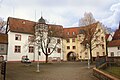
Inner courtyard of the palace - district court until the end of 2011

View into Mühlstrasse

Bait ul-Aman - mosque in Nidda

Nidda old stone bridge


.jpg)

- See also list of cultural monuments in Nidda
- The fruit store from Nidda was moved to Hessenpark .
- Nidda Castle
Museums
- Institute for Church History of Bohemia, Moravia and Silesia
- Niddaer Heimatmuseum , is located in the striking town inn on the market square, built in 1632.
- Zimmermann-Strauss-Museum - Jewish Museum Nidda
- Fire Brigade Museum Nidda
Regular events

- Nidda select - literature, art, illustres, readings by well-known authors or actors.
- nidda in concert - Classical concert series in the historic Parksaal Nidda Bad Salzhausen
- Nidda triathlon for everyone
- swingin'parc - jazz meets…, jazz concert series in the historic Parksaal Nidda- Bad Salzhausen
- Kirmes Unter-Widdersheim, annually on the second weekend in June
- Wallernhausen fair every year on the first weekend in July
- Kirmes Ober-Lais, annually on the last weekend in August
- Folk festivals:
- Spring market
- Autumn market / fair
- Martini market
- Christmas market Nidda
Natural monuments
- Kindstein in the Unter-Widdersheim district, a megalith made of phonolite (Klingstein) as a witness for a prehistoric place of worship. The stone must have been brought to this point from afar. A memorial plaque provides more information.
Personalities
Born in Nidda
- Ambrosius Pelargus (around 1493 / 1494–1561), Dominican and council theologian
- Johannes Pistorius the Elder (Niddanus) (1504–1583), reformer and superintendent
- Johannes Pistorius the Younger (Niddanus) (1546–1608), physician, historian and theologian
- Karl Wilhelm of Hessen-Darmstadt (1693–1707), colonel
- August Konrad Hofmann (1776–1841), statesman
- Wilhelm Manchot (1844–1912), German architect
- Heinrich Busold (1870-1915), the Reichstag and Member of Parliament (SPD)
- Anna Mettbach (1926–2015), Porajmos survivor and contemporary witness, born in Ulfa
- Horst-Klaus Hofmann (* 1928), author and founder of the Young Christians Offensive
- Ottfried Dascher (* 1936), German historian and archivist , born in Ober-Lais
- Gerhard Becker (1942–2017), politician
- Egon Behle (* 1955), manager
- Peter Zimmerling (* 1958), theologian
- Salome Kammer (* 1959), actress, voice soloist, singer and cellist
Associated with Nidda
- Bartholomäus Crasselius (1667–1724), hymn poet, came to Nidda in 1701 as pastor
- Hermann Cardinal Volk (1903–1988), worked as a priestly assistant in 1938/39 and as parish curator in Nidda from 1941–1946
- Casimir Johannes Prince zu Sayn-Wittgenstein-Berleburg (1917-2010), lived in Nidda. His son now lives in the family castle in Nidda
- Fräulein Wunder , girl group and participant in the Bundesvision Song Contest 2009
Remarks
- ↑ Not a member of any public religious community.
Individual evidence
- ↑ Hessian State Statistical Office: Population status on December 31, 2019 (districts and urban districts as well as municipalities, population figures based on the 2011 census) ( help ).
- ↑ Map services of the Federal Agency for Nature Conservation ( information )
- ↑ Heinrich Meyer to Ermgassen, Codex Eberhardi. Volume 2, Marburg 1995-2007, p. 212, excerpt 176.
- ↑ a b c d e Nidda, Wetteraukreis. Historical local dictionary for Hessen. (As of March 23, 2018). In: Landesgeschichtliches Informationssystem Hessen (LAGIS).
- ^ Ailing roof construction in FAZ of February 29, 2012, p. 46.
- ^ A b Georg Wilhelm Justin Wagner : Statistical-topographical-historical description of the Grand Duchy of Hesse: Province of Upper Hesse . tape 3 . Carl Wilhelm Leske, Darmstadt August 1830, OCLC 312528126 , p. 179 ff . ( Online at google books ).
- ^ Michael Rademacher: German administrative history from the unification of the empire in 1871 to the reunification in 1990. State of Hesse. (Online material for the dissertation, Osnabrück 2006).
- ^ Grand Ducal Central Office for State Statistics (ed.): Contributions to the statistics of the Grand Duchy of Hesse . tape 13 . G. Jonghause's Hofbuchhandlung, Darmstadt 1872, DNB 013163434 , OCLC 162730471 , p. 12 ff . ( Online at google books ).
- ↑ Martin Röhling: Niddaer Geschichtsblätter. Issue 9 . The story of the Counts of Nidda and the Counts of Ziegenhain. Ed .: Niddaer Heimatmuseum e. V. Im Selbstverlag, 2005, ISBN 3-9803915-9-0 , p. 75, 115 .
- ^ The affiliation of the Nidda office based on maps from the Historical Atlas of Hesse : Hessen-Marburg 1567-1604 . , Hessen-Kassel and Hessen-Darmstadt 1604–1638 . and Hessen-Darmstadt 1567–1866 .
- ^ Grand Ducal Central Office for State Statistics (ed.): Contributions to the statistics of the Grand Duchy of Hesse . tape 13 . G. Jonghause's Hofbuchhandlung, Darmstadt 1872, DNB 013163434 , OCLC 162730471 , p. 13 ff ., § 26 point d) IX. ( Online at google books ).
- ↑ a b Hessen-Darmstadt state and address calendar 1791 . In the publishing house of the Invaliden-Anstalt, Darmstadt 1791, p. 203 ff . ( Online in the HathiTrust digital library ).
- ↑ Wilhelm von der Nahmer: Handbuch des Rheinischen Particular-Rechts: Development of the territorial and constitutional relations of the German states on both banks of the Rhine: from the first beginning of the French Revolution up to the most recent times . tape 3 . Sauerländer, Frankfurt am Main 1832, OCLC 165696316 , p. 9 ( online at google books ).
- ↑ a b Hessen-Darmstadt state and address calendar 1806 . In the publishing house of the Invaliden-Anstalt, Darmstadt 1806, p. 268 ff . ( Online in the HathiTrust digital library ).
- ↑ Latest countries and ethnology. A geographical reader for all stands. Kur-Hessen, Hessen-Darmstadt and the free cities. tape 22 . Weimar 1821, p. 421 ( online at Google Books ).
- ^ Georg W. Wagner: Statistical-topographical-historical description of the Grand Duchy of Hesse: Province of Upper Hesse . tape 3 . Carl Wilhelm Leske, Darmstadt 1830, p. 181 ff . ( online at Google Books ).
- ↑ Law on the abolition of provinces Starkenburg, Upper Hesse and Rheinhessen from 1 April 1937 . In: The Reichsstatthalter in Hessen Sprengler (Hrsg.): Hessisches Regierungsblatt. 1937 no. 8 , p. 121 ff . ( Online at the information system of the Hessian State Parliament [PDF; 11.2 MB ]).
- ↑ Amalgamation of the city of Nidda and the municipalities of Bad Salzhausen, Borsdorf, Fauerbach near Nidda, Geiß-Nidda, Harb, Kohden, Michelnau, Ober-Lais, Ober-Schmitten, Ober-Widdersheim, Stornfels, Ulfa, Unter-Schmitten, Wallernhausen in the district Büdingen on the new town "Nidda" from November 24, 1970 . In: The Hessian Minister of the Interior (Ed.): State Gazette for the State of Hesse. 1970 No. 49 , p. 2290 , point 2281 ( online at the information system of the Hessian state parliament [PDF; 6.3 MB ]).
- ↑ Law on the reorganization of the districts of Büdingen and Friedberg (GVBl. II 330-19) of July 11, 1972 . In: The Hessian Minister of the Interior (ed.): Law and Ordinance Gazette for the State of Hesse . 1972 No. 17 , p. 230 , § 9 ( online at the information system of the Hessian state parliament [PDF; 1,2 MB ]).
- ^ Federal Statistical Office (ed.): Historical municipality directory for the Federal Republic of Germany. Name, border and key number changes in municipalities, counties and administrative districts from May 27, 1970 to December 31, 1982 . W. Kohlhammer, Stuttgart / Mainz 1983, ISBN 3-17-003263-1 , p. 351-353 .
- ↑ a b Population by nationality group: Nidda, city. In: Zensus2011. Bavarian State Office for Statistics , accessed in April 2020 .
- ↑ Migration background in%: Nidda, city. In: Zensus2011. Bavarian State Office for Statistics , accessed in April 2020 .
- ^ Households by family: Nidda, Stadt. In: Zensus2011. Bavarian State Office for Statistics , accessed in April 2020 .
- ↑ Hessen-Darmstadt state and address calendar 1800 . In the publishing house of the Invaliden-Anstalt, Darmstadt 1800, p. 222 ff . ( Online in the HathiTrust digital library ).
- ↑ Housing spaces 1867 . In: Grossherzogliche Centralstelle für die Landesstatistik (Ed.): Contributions to the statistics of the Grand Duchy of Hesse . tape 13 . G. Jonghause's Hofbuchhandlung, Darmstadt 1877, DNB 013163434 , OCLC 162730484 , p. 121 ( online at google books ).
- ↑ Residential places 1875 . In: Grossherzogliche Centralstelle für die Landesstatistik (Ed.): Contributions to the statistics of the Grand Duchy of Hesse . tape 15 . G. Jonghause's Hofbuchhandlung, Darmstadt 1877, DNB 013163434 , OCLC 162730484 , p. 14 ( online at google books ).
- ↑ a b Hessian Statistical Information System In: Statistics.Hessen.
- ↑ Religion: Nidda, city. In: Zensus2011. Bavarian State Office for Statistics , accessed in April 2020 .
- ^ Result of the municipal election on March 6, 2016. Hessian State Statistical Office, accessed in April 2016 .
- ^ Hessian State Statistical Office: Direct elections in Nidda
- ^ Nidda: Mayors and full-time first councilors of the city of Nidda , accessed on August 9, 2016.
- ↑ Nidda: the history of a city and its surroundings , J. Friedrich Battenberg, ISBN 3-9803915-8-2
- ↑ a b Genealogical Handbook of Bourgeois Families, Volume 94, Hessian Gender Book Volume 9, 1937
- ↑ Genealogical Handbook of Bourgeois Families, Volume 94, Hessisches Geschlechtbuch Volume 9, page 379, 1937
literature
- Literature about Nidda in the Hessian Bibliography
- Literature by and about Nidda in the catalog of the German National Library
- Ottfried Dascher / Reinhard Pfnorr (eds.): NIDDA. The history of a city and its surroundings . Verlag Niddaer Heimatmuseum, Nidda 2nd edition 2003, ISBN 3-9803915-8-2 . [Comprehensive scientific presentation of the Nidda city history with contributions from various authors such as Friedrich Battenberg , Ottfried Dascher, Karl E. Demandt , Eckhart G. Franz , Ulrich Hussong , Lucia Puttrich , Walter G. Rödel, Vera Rupp , Thomas Schilp and others. a.]
- Arnold Spruck : Roots and Paths. A history of the Catholics in and around Nidda with the collaboration of Wolfgang Stingl and Manfred Wollner. Gerhard-Hess-Verlag, Bad Schussenried 2nd edition 2017, ISBN 978-3-87336-609-1 . [Popular scientific presentation of the entire church history of Nidda with an emphasis on Catholic development.]
Web links
- Official website of the city of Nidda
- Nidda (municipality), Wetteraukreis. Historical local dictionary for Hessen. In: Landesgeschichtliches Informationssystem Hessen (LAGIS).
- Nidda, Wetterau district. Historical local dictionary for Hessen. In: Landesgeschichtliches Informationssystem Hessen (LAGIS).
- Link catalog on the subject of Nidda at curlie.org (formerly DMOZ )
- Pictures from back then. In: fotowerk-nidda.de

Altenstadt | Bad Nauheim | Bad Vilbel | Büdingen | Butzbach | Echzell | Florstadt | Friedberg (Hesse) | Gedern | Glauburg | Hirzenhain | Karben | Kefenrod | Limeshain | Munzenberg | Nidda | Niddatal | Ober-Mörlen | Ortenberg | Ranstadt | Reichelsheim (Wetterau) | Rockenberg | Rosbach v. d. Height | Wölfersheim | Wöllstadt
Bad Salzhausen | Borsdorf | Eichelsdorf | Fauerbach | Goat-Nidda | Harb | Kohden | Michelnau | Ober-Lais with Unter-Lais | Ober-Schmitten | Ober-Widdersheim | Schwickartshausen | Stornfels | Ulfa | Unter-Schmitten | Unter-Widdersheim | Wallernhausen