
Weißenstein (Carinthia)
|
market community Weissenstein
|
||
|---|---|---|
| coat of arms | Austria map | |
 |
|
|
| Basic data | ||
| Country: | Austria | |
| State : | Carinthia | |
| Political District : | Villach-Land | |
| License plate : | VL | |
| Surface: | 49.17 km² | |
| Coordinates : | 46 ° 41 ' N , 13 ° 43' E | |
| Height : | 559 m above sea level A. | |
| Residents : | 2,919 (January 1, 2020) | |
| Population density : | 59 inhabitants per km² | |
| Postcodes : | 9500, 9710, 9721, 9722 | |
| Area code : | 0 42 45, 0 42 58 | |
| Community code : | 2 07 26 | |
| NUTS region | AT211 | |
| Address of the municipal administration: |
Dorfplatz 10 9721 Weißenstein |
|
| Website: | ||
| politics | ||
| Mayor : | Hermann Moser ( SPÖ ) | |
|
Municipal Council : ( 2015 ) (19 members) |
||
| Location of Weißenstein in the Villach-Land district | ||
  |
||
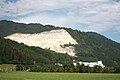
.jpg) Weißenstein (seen from Kellerberg) |
||
| Source: Municipal data from Statistics Austria | ||


Weißenstein is a market town with 2919 inhabitants (as of January 1, 2020) in the Villach-Land district in Carinthia .
geography
Geographical location
Weißenstein is located in the Lower Drautal to the northwest and above Villach . The municipality extends from the valley floor to the south into the Gailtal Alps and to the north into the Nockberge . The highest point is the top of 1517 m above sea level. A. high Schwandnocks on the southern border, which is about 502 m above sea level. A. deepest is at the outflow of the Drava below Gummern.
The community Weißenstein is one of the largest mining communities in Austria and is located in the heart of Carinthia. It borders Villach in the east, Bad Bleiberg in the south, Paternion in the west and Fresach and Treffen in the north .
The place name of the village Weißenstein can be traced back to the steeply rising rock face called "Pleschwand"; this word comes from Old Slavonic and means something like 'bare wall' or 'bald spot'. The place is under this rock formation at the point where the Presingerbach enters the valley floor to the left of the Drau from the northeast. It stands elevated on a cone of rubble that was swept from the Mirnock area into the valley during a storm and buried an older settlement. Parts of the Hadenschloss, which was then on the mountain, were also swept away.
The Drautalbahn (Puch stop, Weißenstein-Kellerberg stop and Paternion-Feistritz stop), the Tauern Autobahn (entrance / exit “Villach West” in Weißenbach), Ferndorfer Landesstraße and Drautal Straße (B 100) run through the market town .
Community structure
The community is divided into four cadastral communities , namely Kellerberg , Puch , Töplitsch and Weißenstein. The municipality includes the following twelve localities (population in brackets as of January 1, 2020):
- Gummern (83)
- Kellerberg (136)
- Lansach (206)
- Lukewarm (17)
- Puch (614)
- Stadelbach (411)
- Parlor (119)
- Toplitsch (487)
- Cheurich (73)
- Uggowitz (25)
- Weissenstein (583)
- Weissenbach (165)
history
As a result of regional language peculiarities and the spelling that grew out of it, Weißenstein was first mentioned as Wizinstein . Over the centuries it became Wizzinstain, Wayßnstain, Weißnstein Weissenstain and finally today's Weißenstein.
Puch was first mentioned in a document in 878. Wizinstein Castle was first mentioned in 1085 as the property of the diocese of Brixen . On May 4, 1201, Weißenstein Castle, like numerous other Upper Carinthian castles and churches, was destroyed by a strong earthquake with the epicenter in the Liesertal .
Kellerberg was first mentioned as Chellerberch in 1251 and belonged to the Counts of Ortenburg . The Kellerberg Castle was destroyed in the earthquake in 1348. In 1478 the Turks devastated Kellerberg.
When the local parishes were formed in Carinthia in 1849/1850, Weißenstein and Kellerberg were initially independent parishes. Kellerberg was incorporated into Paternion in 1865 , but became independent again in 1899. As part of a municipal structural reform, the Kellerberg on the right of the Drau and the Weißenstein on the left of the Drau were merged to form the municipality of Weißenstein on January 1, 1973. On July 30, 2006 she was given the right to use the designation " market town ".
population
Population development
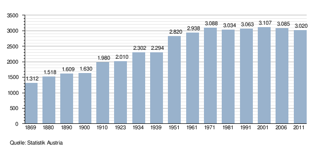
On January 1, 2001, 3,107 people lived in the market town of Weißenstein. 96.7% or 3,004 people were Austrian citizens, 103 people or 3.3% were non-Austrian. The majority of the people born abroad came from the countries of the former Yugoslavia (69 people or 2.2% of the total population), the rest are all Germans (34 people or 1.1%).
Religions
52% of Weißenstein's residents are Roman Catholic , 41% Protestant , 0.8% Muslim and 4.5% have no religious beliefs.
Culture and sights

- Parish church of St. Leonhard in Weißenstein (first mentioned in documents in 1149)
- Filial church St. Gotthard in Lansach (first mentioned in documents in 1487)
- Parish church St. Ulrich in Kellerberg (first mentioned in a document in 1309)
- Filial church St. Lambert in Töplitsch (first mentioned in documents in 1428)
- Evangelical Church Puch (built in 1783)
- Kellerberg-Rothauer Castle is one of those three castles in Carinthia whose architectural style is characterized by round corner towers that are placed diagonally on a massive, cubic structure. It was first mentioned in a document in 1507.
- From the Weißenstein castle ruins , an approx. 70 m long, north-south running and heavily crumbled wall made of rubble stones, which is between 10 and 30 m wide and a maximum of 90 cm high, has been preserved.
- Dorfbogen Töplitsch (approx. 10 m high arch with towers indicated on the sides, built in 1998 by the village population)
Economy and Infrastructure
According to the 2001 census of workplaces, there are 86 workplaces with 737 employees in the municipality as well as 908 out-commuters and 431 in-commuters. There are 112 agricultural and forestry holdings, 39 of which are the main occupation, which together cultivate 4,079 hectares (1999).
- Important industrial and mining companies in the market town

Chemical plant ÖCW Degussa-Evonik
OMYA Gummern lime mine

Neuper GmbH. Chippings and pebbles


Establishments
- ÖCW ( Austrian Chemical Works ; a branch of Degussa CEE GmbH, subsidiary of Evonik Degussa ). The ÖCW in Weißenstein, built in 1908, was the first hydrogen peroxide factory in the world and still produces this chemical today.
- OMYA . The stone works of OMYA GesmbH in Gummern is the most important and largest marble quarry in Carinthia. It is a key plant in supplying the Austrian, southern German and northern Italian paper, paint, lacquer and plastics industries with calcium carbonate extracted from marble . The rubber marble broken here was already used in antiquity.
- Kellerberg power plant . The power station is located at 85.5 kilometers from the Drava at Kellerberger Winkel. It is a pillar power plant with running and surge operation using the storage outflows from Western Carinthia with an annual generation of 103.2 GWh , which goes into the 20 kV network of Kelag .
- Lauster stone construction . From founded in 1958 Lauster GmbH of the quarry is Krastal occurring Krastaler marble mined and processed in our own plants. Krastaler marble is installed throughout Austria and also exported to other countries such as B. to Germany or Italy .
- Neuper GmbH . In Kellerberg, Neuper GmbH extracts various grit sizes for the concrete industry and road construction. Since July 2009, screed and Torkret ( shotcrete ) have been mixed and loaded in the newly built facility .
- Hofer KG . The Hofer KG branch in Weißenbach is one of the largest buildings in Carinthia in terms of area. All Hofer locations in Carinthia and East Tyrol, as well as parts of Salzburg and Styria, are looked after and supplied from here.
- Lindpointner Torsysteme Süd GmbH . The Lindpointner Torsysteme branch in Töplitsch has existed since 2004 and Töplitsch looks after all of Carinthia, East Tyrol, Slovenia as well as parts of Salzburg and Styria.
There are five volunteer fire brigades in the community , which are among the most successful in all of Carinthia in terms of competition. The volunteer fire department Töplitsch achieved numerous national championship titles as well as gold and bronze medals at the International Fire Brigade Competitions of CTIF (World Championships).
Handicrafts have also established themselves in the region around the wake of the stone processing industry . With the Rauter glass blowing factory , one of the last manufacturers of its kind has been preserved here. Glass blowing in the Alpine region differs from glass production in Murano . White, transparent glass is mostly used in the alpine region.
Since time immemorial there have been ferries across the Drava in this region, connecting the following villages:
- Gummern with Weißenbach
- Puch with Töplitsch or Stadelbach - This ferry was removed from Töplitsch and Stadelbach after the rump claw disease outbreak in Puch in 1804 to protect the population. A resumption of operations in 1809 was prevented by a popular uprising.
- Kellerberg with Weißenstein
- Lansach with Feffernitz
- Stuben with Pobersach
politics
Municipal council
The council of Weißenstein has 19 members and has been composed as follows since the council elections in 2015 :
The directly elected mayor is Hermann Moser (SPÖ).
coat of arms
The coat of arms of Weißenstein shows "in blue below three silvery boulders stacked one inside the other, the middle one raised, the other two lowered." The blue background represents the abundance of springs and water in the market town, the white rocks represented the abundance of rocks and ore of the mining area the ancient Celts and Romans knew how to use it. The Krastal marble serves as an outstanding example .
At the same time, the rocks probably allude to the Pleschwand towering north of the village, at the foot of which Wizinstain Castle was built in the 11th century, after which a knightly family was once named.
The coat of arms and flag were awarded to the municipality on August 5, 1981, the flag is blue and white with an incorporated coat of arms.
Partner municipality
The partner community of Weißenstein has been Nidda in Hesse since 1990 .
Personalities
- Leo Lukas (* 1908, † 1979), politician, councilor of Weißenstein.
- Johann Fruhmann (* 1928, † 1985), painter.
- Günther Steyrer (* 1931, † 1986), dialect poet, composer, choir director of the AGV Weißenstein, director of the Weißenstein elementary school 1973 - 1978.
- Manfred Ebner (* 1953), politician.
- Hubert Dörer (* 1966), two-time world champion in powerlifting.
- Christian Jennes (* 1997), ice hockey player.
- Elias Keller (* 2007), pianist, Mozarteum Salzburg.
literature
- Ludwig F. Haderer: Weissenstein. Building blocks for the story . 1996. [available from the Weißenstein municipal office]
Web links
- Market town of Weißenstein
- 20726 - Weißenstein (Carinthia). Community data, Statistics Austria .
Individual evidence
- ↑ Statistics Austria: Population on January 1st, 2020 by locality (area status on January 1st, 2020) , ( CSV )
- ^ Dehio manual. The art monuments of Austria. Carinthia . Anton Schroll, Vienna 2001, ISBN 3-7031-0712-X , p. 1059.
- ^ Rauter glass blowing in Echt Kärnten ( Memento from May 14, 2012 in the Internet Archive )
- ^ Wilhelm Deuer: The Carinthian community arms . Verlag des Kärntner Landesarchiv, Klagenfurt 2006, ISBN 3-900531-64-1 , p. 294.
Afritz am See | Arnoldstein | Arriach | Bad Bleiberg | Feistritz an der Gail | Feld am See | Ferndorf | Finkenstein am Faaker See | Fresach | Hohenthurn | Nötsch im Gailtal | Paternion | Rosegg | Sankt Jakob im Rosental | Stockenboi | Meeting at Ossiacher See | Velden am Wörther See | Weißenstein | Wernberg