Nockberge
| Nockberge | ||
|---|---|---|
| Highest peak | Eisenhut ( 2441 m above sea level ) | |
| location | Carinthia , Salzburg , Styria | |
| part of | Gurktal Alps , Central Alps | |
| Classification according to | Trimmel 2710 | |
|
|
||
| Coordinates | 46 ° 57 '11 " N , 13 ° 55' 45" E | |
| particularities | Nockberge Biosphere Reserve | |
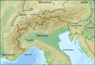
The Nock Mountains (rarely also the Nock Mountains ) are the westernmost and highest mountain group of the Gurktal Alps and extend over parts of Carinthia , Salzburg and Styria . Their appearance is characterized by numerous dome-like and grassy mountain peaks. The highest point is the 2441 m above sea level. A. high Eisenhut in Styria. Similarly, the count Rosennock with 2440 m above sea level. A. and the Große Königstuhl ( 2336 m above sea level ), which represents the triangle between the federal states of Styria, Salzburg and Carinthia, to the Nock Mountains. The Nockberge Biosphere Reserve encompasses the central area of the Nockberge .
geography
The Nockberge form the westernmost part of the Gurktal Alps, they are separated from the Mur to the Niedere Tauern in the north as far as the Katschberg ( 1641 m above sea level ) . In the west, Lieser and Drau separate the Nockberge from the Ankogel group of the Hohe Tauern and the Gailtal Alps . To the south of the Ossiacher See , the Sattnitz and Klagenfurt basins , another part of the Gurktal Alps, connect . To the east within the Gurktal Alps, they are bounded by the Gurk - Flattnitzer Höhe ( 1400 m above sea level ) - Paalbach line.
The term nock for " knoll " is typical for the peaks here. The word is also found sporadically in Salzburg and Tyrol (e.g. Hoher Nock im Rofan, Nockspitze / Saile near Innsbruck, Nockstein near Salzburg, often in South Tyrol) in the sense of 'overgrown rocks, highest elevation of a flattened mountain top', related to German Nocke (' rounded extension ', on the camshaft ). Here they are of more recent date, and probably a transcription of older Slavic nik names (so the rose (n) ock was still Rosenik in the 19th century ). Nonetheless, the word here quickly became an identity. The term Nocky Mountains , based on the Rocky Mountains, has recently appeared in tourism advertising .
The Nockberge can be divided into a total of eight subgroups. South of Bad Kleinkirchheim are the sticks of the Mirnock ( 2110 m above sea level ) with a remarkable prominence of 1,343 m as well as the Wöllaner Nock ( 2145 m above sea level ) and the Gerlitzen ( 1909 m above sea level ). The central part of the Nockberge is formed by the Millstätter Alpe ( 2101 m above sea level ) and the Rosennock ( 2440 m above sea level ). In the north are the mountain ranges of the Schwarzwand ( 2241 m above sea level ), the Königstuhl ( 2336 m above sea level ) and the Eisenhut ( 2441 m above sea level ). The Millstätter See ridge forms the end in the southwest .
literature
Kimmer / Lang / Baumhackl, Nockberge (Rother hiking guide), 5th, completely revised edition, 2017. ISBN 978-3-7633-4512-0 .
Web links
Individual evidence
- ^ A b Heinz Pohl: Mountain names in Austria (on members.chello.at), under location names according to the form and in particular the entry Nockberge under 2. The names of the most famous Carinthian mountains.
- ↑ There is also a Nock spring near Schönberg in the Stubai Valley
- ↑ For example: nockalmstrasse.at , merian.de , wienerzeitung.at , bz-berlin.de

