Schönberg in the Stubai Valley
|
Schönberg in the Stubai Valley
|
||
|---|---|---|
| coat of arms | Austria map | |
|
|
||
| Basic data | ||
| Country: | Austria | |
| State : | Tyrol | |
| Political District : | Innsbruck country | |
| License plate : | IL | |
| Surface: | 7.45 km² | |
| Coordinates : | 47 ° 11 ' N , 11 ° 24' E | |
| Height : | 1013 m above sea level A. | |
| Residents : | 1.109 (January 1, 2020) | |
| Postal code : | 6141 | |
| Area code : | 05225 | |
| Community code : | 7 03 50 | |
| NUTS region | AT332 | |
| Address of the municipal administration: |
Römerstrasse 1 6141 Schönberg in the Stubai Valley |
|
| Website: | ||
| politics | ||
| Mayor : | Hermann Steixner (Schönberg habitat) | |
|
Municipal Council : (2016) (13 members) |
||
| Location of Schönberg in the Stubai Valley in the Innsbruck-Land district | ||
| Source: Municipal data from Statistics Austria | ||
Schönberg im Stubaital is a municipality with 1109 inhabitants (as of January 1, 2020) in the Wipp- and Stubaital in the Innsbruck judicial district and Innsbruck-Land district in Tyrol ( Austria ).
geography
Schönberg is located about eleven kilometers south of Innsbruck between the Ruetz and Sill rivers .
The municipality of the small community essentially comprises the plateau, which, as a valley shoulder, forms the continuation of the low mountain range around Innsbruck , and which is the north-eastern spur of the Serlesstock ( Serles 2718 m above sea level ) and the Habicht group of the Stubai Alps .
To the north, the whole area between the Sillschlucht and Ruetzschucht belongs to the municipality, up to the Ruetz estuary at the Stephansbrücke of the old Brennerstraße, inward of the Stubaital the right side of the Ruetzschucht up to the Nockquelle , and to the south the slopes of the Gleinserberg ( 1720 m above sea level ) on the Wipptal side Foothills of the Serles.
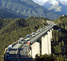
The Sillschlucht spans the Europe bridge the Brennerautobahn A 13 of Dub across.
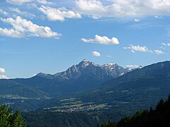
View from the Elferspitze into the Stubai Valley, the very last place out of the valley on the right is Schönberg (opposite in the middle Patsch , in the back Inntal and Nordkette )
Community structure
The community consists of a single cadastral community (Schönberg) , a locality and a counting district (both Schönberg im Stubaital ). Districts are: Schönberg, Gleins, Graslboden, Ruetzwerk, Sillwerk and Unterberg
The center of the cluster is the village of Schönberg . Other places are the Rotten Ruetzwerk and Unterberg (parts also in Mutters ), and the scattered houses Sillwerk (parts also in Patsch ) out of the valley, as well as the Rotte Gleins south above.
The municipality is the seat of the Tyrolean Planning Association Stubaital and provides its chairman with Mayor Steixner. The municipality is also part of the Stubai Tirol tourist region , and the tourist office is based in the Stubaitalhaus in Neustift .
Neighboring communities
| mothers | innsbruck | Slap |
| Telfes in the Stubai |

|
Elbows |
| Bodice | Mühlbachl |
history
Roman street finds near the Europabrücke prove that Schönberg traded across the Brenner as early as Roman times. The street found is via Raetia, one of the most important streets of the time. It ran from Unterberg over a steep climb to Schönberg. Coins were also found.
The place name is mentioned for the first time in a document from Wilten Abbey from 1180 with Fridricus de Schœnberch . The cartographer Peter Anich recorded a Schönberg castle on his map .
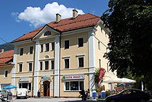
During the Battle of the Bergisel , Andreas Hofer had his headquarters several times in the former Gasthof Domanig, today's municipal office.
The new Brennerstrasse was planned by Karl Ritter von Ghega and built between 1836 and 1845. The Stephansbrücke was also completed in 1845 .
Population development

Capital of the municipality
| Schönberg im Stubaital ( village ) | |
|---|---|
| Basic data | |
| Pole. District , state | Innsbruck-Land , Tyrol |
| Judicial district | innsbruck |
| Pole. local community | Schönberg im Stubaital ( KG Schönberg) |
| Locality | Schönberg in the Stubai Valley |
| Coordinates | 47 ° 11 ′ 7 ″ N , 11 ° 24 ′ 13 ″ E |
| height | 1013 m above sea level A. |
| Statistical identification | |
| Counting district / district | Schönberg im Stubaital (70 350 000) |
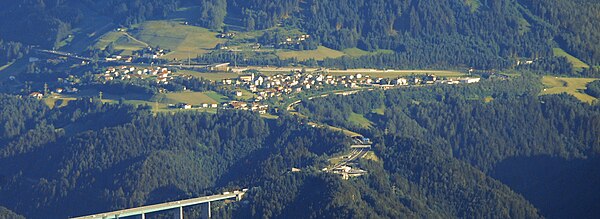
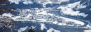 Schönberg from the west, with toll booth |
|
| Source: STAT : index of places ; BEV : GEONAM ; TIRIS | |
The main town of the municipality is the village of Schönberg in the Stubai Valley . It is located about eleven kilometers south of Innsbruck city center . The place is around 1010 m above sea level. A. Height on the plateau between Sillschlucht and Ruetzschucht . The place thus forms the valley entrance from the Wipptal der Sill into the Stubai valley of the Ruetz.
Schönberg is enclosed on three sides by the Brenner Autobahn . The Schönberg / Stubaital junction (Exit 10) and the main toll station Schönberg for the toll motorway are located here to the west of the town . The old Römerstraße (today Brenner Straße B 182) once ran through the village, but was led further down the valley after the construction of the Stephansbrücke , the junction of Stubaital Straße B 183, the main street of the village, to the B 182 is at the southern end of the village.
The place includes largely the entire community population.
- Neighboring places
|
Ruetzwerk Sillwerk
(Gem. Schönberg and Patsch )
|
Kehr (Gem. Patsch ) | |
| Telfer Wiesen (Gem. Telfes i.St. ) |

|
|
| Oweges (Gem. Mieders ) | Gleins |
Niederstraße (all Gem. Elbögen )
Matreiwald (Gem. Mühlbachl )
|
Culture and sights
- The baroque parish church of the Holy Cross, built by Franz de Paula Penz in 1749, is worth seeing .
traffic
Schönberg is connected to Innsbruck by bus lines 590 and 4140, line 4145 goes to the Wipptal . On nights from Friday to Saturday and Saturday to Sunday, the Nightliner 590N connects the community with all communities in the Stubai and Innsbruck. In addition, ski bus line 4 runs to Schlick 2000 in winter .
politics
- Habitat Schönberg: 6
- Schönberg ACTIVE: 4
- Community list Schönberg: 3
In the municipal council election on February 28, 2016, the list Lebensraum Schönberg achieved a relative majority with 6 mandates, the Independent List of All Community Citizens - Schönberg aktiv reached 2nd place and has 4 mandates. The third parliamentary group is the Schönberg community list, which has 3 mandates, and is represented in the community council. The Greens Schönberg also competed for the first time , but failed because of their basic mandate.
- mayor
- 1945–1953 Johann Sprenger
- 1953-1983 Hans Fontan
- 1983-2001 Norbert Franceschinel
- 2001–2012 Willi Sprenger (community list Schönberg)
- since 2012 Hermann Steixner (living space Schönberg)
coat of arms
The coat of arms of Schönberg in the Stubai Valley is a schematic representation of the Europe Bridge.
Web links
- 70350 - Schönberg in the Stubai Valley. Community data, Statistics Austria .
- in the Stubai Valley Entry on Schönberg in the Stubai Valley in the Austria Forum (in the AEIOU Austria Lexicon )
- Community website
- www.stubai.at Website of the Stubai region
Individual evidence
- ↑ Martin Bitschnau , Hannes Obermair : Tiroler Urkundenbuch, II. Department: The documents on the history of the Inn, Eisack and Pustertal valleys. Volume 2: 1140-1200 . Universitätsverlag Wagner, Innsbruck 2012, ISBN 978-3-7030-0485-8 , p. 281-286, no. 758 .
- ↑ wahlen.tirol.gv.at , wahlen.tirol.gv.at


