
Ampass
|
Ampass
|
||
|---|---|---|
| coat of arms | Austria map | |
 |
|
|
| Basic data | ||
| Country: | Austria | |
| State : | Tyrol | |
| Political District : | Innsbruck country | |
| License plate : | IL | |
| Surface: | 7.96 km² | |
| Coordinates : | 47 ° 15 ' N , 11 ° 28' E | |
| Height : | 651 m above sea level A. | |
| Residents : | 1,845 (January 1, 2020) | |
| Population density : | 232 inhabitants per km² | |
| Postal code : | 6070 | |
| Area code : | 0512 | |
| Community code : | 7 03 03 | |
| NUTS region | AT332 | |
| Address of the municipal administration: |
Römerstrasse 21 A 6070 Ampass |
|
| Website: | ||
| politics | ||
| Mayor : | Hubert Kirchmair | |
| Location of Ampass in the Innsbruck-Land district | ||
  |
||
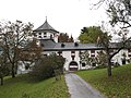
 Ampass village center with St. Vitus Church and parish church |
||
| Source: Municipal data from Statistics Austria | ||


Ampass is a municipality with 1845 inhabitants (as of January 1, 2020) in the Innsbruck-Land district of the state of Tyrol in Austria . The municipality is located in the judicial district of Hall in Tirol .
geography
Ampass is located southeast of Innsbruck in the southeast low mountain range . In the north the border runs on the Inn , in the west Ampass borders directly on Innsbruck, which is about 8 kilometers away. The village center is located in a kind of valley basin.
Land use
Of the 7.9 km² community area (as of 2011, Tirol Atlas):

Neighboring communities
Aldrans , Hall in Tirol , Innsbruck , Rinn , Rum , Thaur , Tulfes
Community structure
Ampass as a community is divided in a cadastral and Zählsprengel . The associated districts are:
- Ampass village
- Haller Inn Bridge
- Houses
- Peerhöfe
- Zimmer Valley
- Ebenwald
- Agenbach settlement
history
Prehistoric finds testify to an early settlement, the oldest among them date from the 15th century BC. The Iron Age sanctuary at Demlfeld brought particularly rich finds .
Ampass is located on the old salt road from Hall to Matrei , east of Innsbruck on the south bank of the Inn , on which the salt extracted in the Hall valley was transported south. This path is likely to date back to at least Roman times, a side route Hall - Häuser - Patsch of Brennerstrasse should have run here. A 1.9 meter high granite milestone built in 1254 is said to have marked the boundary to the Wilten parish and is still in its original location. The salt transports reached their peak around 1490. Today the course of the Salzstraße is followed by the Ellbögener Straße (L 38).
Ampass is first mentioned in a document in 1145 as Ampans or Ambans (in a document from Wilten Abbey, however, which was not made until the 14th century ), then with Pastor Eberhard ( Eberhardus plebanus de Ambans ) in 1157/68. The name should be pre-Romanesque and mean in Celtic 'between two streams'. As an independent municipality, Ampass is first mentioned in 1312 in the Inntaler tax book.
Battles in the Tyrolean freedom struggle in 1809 also took place in Ampass , Kaspar Sautner was Ampasser. A hiking trail around Ampass is named after him.
Ampass was exposed to population decline from the middle of the 19th century to 1910, but like many other municipalities in the area around Innsbruck it has developed from an agricultural town to a residential municipality in recent decades and has experienced an increase in population in recent years.
Population development

politics
The last mayoral elections took place at the same time as the municipal council elections on February 28, 2016.
Hubert Kirchmair was re-elected mayor.
| Political party | percent | be right | Seats on the local council |
|---|---|---|---|
| Parish list | 55.26% | 573 | 8th |
| Together for Ampass ÖVP | 31.53% | 327 | 4th |
| Free and independent Ampasser list | 13.21% | 137 | 1 |
coat of arms
Blazon : In green a silver pole with a black quarter column.
The municipal coat of arms, awarded in 1974, shows the quarter column , a plague column , as the town's landmark. The silver stake represents the salt road that led through Ampass.
Infrastructure and economy
Sports
Ampass has a sports field, a beach volleyball court and, in winter, an ice rink.
In addition, some paths, especially in the Zimmertal , Peerhöfe and Ebenwald areas , are used as hiking routes and are considered Innsbruck's local recreation area.

Motorway station
The Rosenberger restaurant was closed in January 2019 - in the restructuring process without self-administration since December 2018.
Culture and sights
The Ampasser landmark is the plague column , also called the quarter column , which can also be seen on the coat of arms.
Parish Church of John the Baptist

The parish church includes a church building and a bell tower at the top of the Kirchbühel. In 1739 the bell, which was too heavy for the normal church tower, was housed in that tower.
Around 1000 there is said to have been an unknown castle on the Kirchbühel. According to documents, the castle chapel built by King Heinrich IV , which was later elevated to capella regalis (royal chapel), was inaugurated by Bishop Altwin von Brixen between 1048 and 1097 . The resulting late Gothic parish church was later redesigned in Baroque style . In the past it has often seen widespread destruction, such as a fire, destruction by troops in the Thirty Years' War and by a major earthquake in 1698.
Due to its exceptional location and uniqueness, St. John's Church is very popular today as a wedding church.
Vitus Church
The Gothic St. Vitus Church, built by carters, was mentioned for the first time in 1429. This can still be seen today in the church's intercession by the carters.
Quarter column
The Ampasser landmark, the quarter column, also known as the plague column, is one of the most important Gothic wayside shrines in North Tyrol. It is said to come from the first half of the 16th century and is located near the Sonnenbühel . After an act of vandalism in 1876, the quarter column was renovated, followed by two more restorations in 1970 and 1997.
Historic Buildings
- Taschenlehen mansion : The core of the building dates from the end of the 15th century, and was converted to Baroque style in the first half of the 17th century. Before 1694 the farm was called Lehen in the Achleite .
- Ansitz Wallpach / Schwanenfeld / Stachler: The building, which is now used as a farm house, dates back to the 16th and 17th centuries and served as the summer residence of the Wallpach family, who were ennobled by craftsmen from Hall.
- The Widum , a Wittum (parsonage), late Gothic in core, expanded in 1674 in Baroque style.
Pocket seat
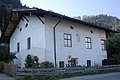
Wallpach residence

Widum


literature
- Dorothea Mair: Border area and center: A synopsis of selected finds from the Roman Empire to the early Middle Ages as well as excerpts from the excavations in the Widumfeld in 1999 and 2000. Find topography KG Ampass. Diploma thesis (online, uibk.ac.at).
Web links
- Ampass , in the history database ofthe association "fontes historiae - sources of history"
- University of Innsbruck, Institute of Archeology: The Ampass-Aldrans settlement chamber based on archaeological findings and finds
- Spherical panorama of Ampass, taken over the Johanneskirche
Individual evidence
- ↑ Land use by the municipality of Ampass after calculating the Corine land cover. Tirol Atlas, accessed on May 8, 2015 .
- ↑ a b History of Tyrol: Ampass . Retrieved May 19, 2013.
- ↑ Ampass municipality: Ampass . Folder. With an overview from history . ( online ).
- ↑ Martin Bitschnau , Hannes Obermair : Tiroler Urkundenbuch, II. Department: The documents on the history of the Inn, Eisack and Pustertal valleys. Volume 2: 1140-1200 . Universitätsverlag Wagner, Innsbruck 2012, ISBN 978-3-7030-0485-8 , p. 35 ff., No. 417 a. 517 .
- ↑ Ampass municipality . Wahlen.tirol.gv.at. Archived from the original on January 21, 2012. Retrieved on May 8, 2016.
- ^ Eduard Widmoser: Tiroler Wappenfibel . Tyrolia-Verlag, Innsbruck 1978, ISBN 3-7022-1324-4 , p. 17 .
- ↑ Rosenberger: First rest stop was closed orf.at, January 9, 2019, accessed January 10, 2019.
- ↑ Michael Unterwurzacher: In the realm of Patscherkofel . 2009, ISBN 978-3-8391-0419-4 ( limited preview in Google Book Search [accessed March 17, 2013]).
- ↑ For romantic weddings, entry Ampass . innsbruck.info. Archived from the original on April 2, 2015. Retrieved May 19, 2013.
City: Hall in Tirol . Market communities: Fulpmes • Matrei am Brenner • Steinach am Brenner • Völs • Wattens • Zirl . Municipalities: Absam • Aldrans • Ampass • Axams • Baumkirchen • Birgitz • Ellbögen • Flaurling • Fritzens • Gnadenwald • Götzens • Gries am Brenner • Gries im Sellrain • Grinzens • Gschnitz • Hatting • Inzing • Kematen in Tirol • Kolsass • Kolsassberg • Lans • Leutasch • Mieders • Mils • Mühlbachl • Mutters • Natters • Navis • Neustift im Stubaital • Oberhofen im Inntal • Obernberg am Brenner • Oberperfuss • Patsch • Pettnau • Pfaffenhofen • Pfons • Polling in Tirol • Ranggen • Reith bei Seefeld • Rinn • Rum • St. Sigmund im Sellrain • Scharnitz • Schmirn • Schönberg im Stubaital • Seefeld in Tirol • Sellrain • Sistrans • Telfes im Stubai • Telfs • Thaur • Trins • Tulfes • Unterperfuss • Vals • Volders • Wattenberg • Wildermieming .