Polling in Tyrol
|
Polling in Tyrol
|
||
|---|---|---|
| coat of arms | Austria map | |
|
|
||
| Basic data | ||
| Country: | Austria | |
| State : | Tyrol | |
| Political District : | Innsbruck country | |
| License plate : | IL | |
| Surface: | 4.96 km² | |
| Coordinates : | 47 ° 17 ' N , 11 ° 9' E | |
| Height : | 615 m above sea level A. | |
| Residents : | 1,230 (January 1, 2020) | |
| Population density : | 248 inhabitants per km² | |
| Postal code : | 6404 | |
| Area code : | 05238 | |
| Community code : | 7 03 42 | |
| NUTS region | AT332 | |
| Address of the municipal administration: |
Polling 107 6404 Polling in Tyrol |
|
| Website: | ||
| politics | ||
| Mayor : | Gottlieb Jäger | |
| Location of Polling in Tyrol in the Innsbruck-Land district | ||

|
||
| Source: Municipal data from Statistics Austria | ||
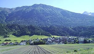
Polling in Tirol is a municipality with 1230 inhabitants (as of January 1, 2020) in the Innsbruck-Land district in Tyrol ( Austria ). The community is located in the judicial district of Telfs .
Today, Polling is a residential and commuter community due to its proximity to the greater Innsbruck area.
geography
Polling is located in the Upper Inn Valley between Zirl and Telfs , around 20 kilometers west of Innsbruck . The municipality extends from the valley area south of the Inn over the Pollingberg (860 meters) to the area of the Flaurlinger Joch at 2211 meters. Neighboring communities are Flaurling , Hatting and Pettnau .
Community structure
The municipality includes the following two localities (population in brackets as of January 1, 2020):
- Polling in Tyrol (1034)
- Pollingberg (196)
The municipality consists of the cadastral municipality Polling.
history
The settlement first appeared in a document in 763 as "Pollinga" - part of the founding equipment of the monastery church of St. Peter built in Scharnitz by the diocese of Freising . The foundation of the settlement on several cones of debris from brooks, which flow into the then marshy Inn valley, probably goes back to the Bavarians immigrating from the Seefeld saddle .
The yards of the Pollingberg go back to the high Middle Ages. From this time on, the salt transports from Hall in Tyrol also led west through the villages, which, in addition to agriculture, were able to generate income from the transport.
Population development

politics
The last mayoral elections took place at the same time as the municipal council elections on February 28, 2016.
| Candidates | be right | % | BGM |
|---|---|---|---|
| Hunter Gottlieb | 523 | 74.71 | YES |
| Greil Robert | 177 | 25.29 | NO |
City council election results of February 28, 2016
| Political party | percent | be right | Seats on the local council |
|---|---|---|---|
| General citizens list polling | 55.95 | 395 | 7th |
| Village list polling | 23.65 | 167 | 2 |
| Colorful for polling | 20.40 | 144 | 2 |
Culture and sights
traffic
The place can be reached via the Inntal motorway (A 12) with the exits Telfs-Ost in the west or Zirl-West in the east.
There is a rail connection via the Arlbergbahn with Flaurling station .
Web links
- 70342 - Polling in Tyrol. Community data, Statistics Austria .
Individual evidence
- ↑ Statistics Austria: Population on January 1st, 2020 by locality (area status on January 1st, 2020) , ( CSV )
- ^ Martin Bitschnau , Hannes Obermair : Tiroler Urkundenbuch. II. Department: The documents on the history of the Inn, Eisack and Pustertal valleys. Volume 1: By the year 1140 . Ed .: Tiroler Landesmuseen-Betriebsgesellschaft mb H. Universitätsverlag Wagner, Innsbruck 2009, ISBN 978-3-7030-0469-8 , p. 25-27, No. 45 .
- ↑ https://wahlen.tirol.gv.at/gemeinderats_und_buergermeisterwahlen_2016/gemeinden/polling_in_tirol.html


