
Pfaffenhofen (Tyrol)
|
Pfaffenhofen
|
||
|---|---|---|
| coat of arms | Austria map | |
 |
|
|
| Basic data | ||
| Country: | Austria | |
| State : | Tyrol | |
| Political District : | Innsbruck country | |
| License plate : | IL | |
| Surface: | 7 km² | |
| Coordinates : | 47 ° 18 ' N , 11 ° 5' E | |
| Height : | 642 m above sea level A. | |
| Residents : | 1,143 (January 1, 2020) | |
| Postal code : | 6405 | |
| Area code : | 05262 | |
| Community code : | 7 03 40 | |
| NUTS region | AT332 | |
| Address of the municipal administration: |
Lehngasse 1 6405 Pfaffenhofen |
|
| Website: | ||
| politics | ||
| Mayor : | Andreas Schmid (Open Village List) | |
|
Municipal Council : (2016) (13 members) |
||
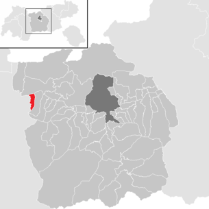
| Location of Pfaffenhofen in the Innsbruck-Land district | ||
  |
||

|
||
| Source: Municipal data from Statistics Austria | ||


Pfaffenhofen is a municipality with 1143 inhabitants (as of January 1, 2020) in the Innsbruck-Land district in Tyrol ( Austria ). The community is located in the judicial district of Telfs .
geography
Pfaffenhofen is located in the Upper Inn Valley near Telfs, south of the Inn . The highest point in the community is the 2796 m high Hocheder . In terms of settlement, the place is connected to Telfs and Oberhofen. To the west, the Imst district adjoins the municipality of Rietz .
Community structure
Pfaffenhofen consists of a single cadastral community of the same name .
|
structure
|
||||||
|
Legend for the breakdown table
|
Neighboring communities
Two of the three neighboring communities are in the Innsbruck-Land district, one in the Imst district .
| Telfs | ||
| Rietz (Imst district) |
.svg)
|
Oberhofen in the Inn Valley |
| Oberhofen in the Inn Valley |
history
Long before the name “Pfaffenhofen” existed, people lived on this soil. The settlement of the valley basin goes back to the Urnfield culture .
Archaeological finds on the Ematbödele in Telfs and on the “Trappeleacker” in Pfaffenhofen, among other places, show that the area has been inhabited for the past 3000 years.
Christians settled in the church early on. In the 5th century, a traveling bishop even settled in Pfaffenhofen for some time. The bishopric from this period can still be admired today under the presbytery of the parish church of the Assumption.
The first documentary mention of Pfaffenhofen comes from the year 1197. In a document, Bishop Eberhard von Brixen ended the dispute over an estate in “Phafenhofen” between the St. Ulrich Abbey in Augsburg and Brixen canons. However, recent research assumes that the place is actually Pfaffenhofen an der Glonn , where the St. Ulrich Abbey - in contrast to Pfaffenhofen in Tyrol - had extensive possessions since the 12th century.
In 1239 Hörtenberg Castle was first mentioned in a document. Around 1300, today's Hörtenberg ruin was the place of jurisdiction for a larger district. Hörtenberg was bought by Count Meinrad II. Of Tyrol from the earlier teachings of the Counts of Eschenlohe and thus finally went to Tyrol as an incorporation.
On August 5, 1706, a striking lightning bolt ignited the powder supply of around 1,500 hundredweight stored there, and the lock blew up. All that was left was the still existing castle keep, which today has a roof to protect it from further deterioration. The community acquired the castle ruins and their facilities and has since invested in the infrastructure and maintenance so that the castle ruins are available as a destination and event location over the summer months.
coat of arms
On October 28, 1955, Pfaffenhofen was awarded a municipal coat of arms by the Tyrolean state government.
Blazon :
- “A shield of silver and red divided with battlements. At the top a black trident upright, the middle raised trident tip ending as an arrow, with an arrowhead as a stem. "
The red battlements symbolize Hörtenberg Castle and the trident symbolizes the jurisdiction originally located there. The colors of the municipal flag are: white-red.
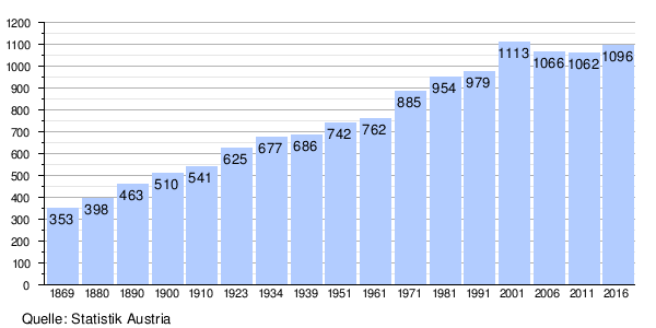
Population development
politics
The last mayoral elections took place at the same time as the municipal council elections on February 28, 2016. Andreas Schmid was elected mayor with 404 votes / 70.51%.
| Political party | percent | be right | Seats on the local council | Coupling |
|---|---|---|---|---|
| OPEN VILLAGE LIST - Mayor Andreas Schmid | 54.25% | 351 | 7th | |
| Independent list Pfaffenhofen - ULP | 18.24% | 118 | 2 | |
| List 4 you | 27.51% | 178 | 4th |
Culture and sights


- Hörtenberg castle ruins
- Catholic parish church Pfaffenhofen Assumption of Mary
traffic
- Road: Pfaffenhofen is via the Inntal Autobahn A 12 with the Telfs-West exit (exit 105).
- Train: The Arlbergbahn with the Telfs-Pfaffenhofen train station which is located in Pfaffenhof's municipality. There, rapid transit trains of the S-Bahn Tirol on lines S1 and S2 run alternating every 30 minutes.
Web links
- 70340 - Pfaffenhofen. Community data, Statistics Austria .
- www.pfaffenhofen.tirol.gv.at - homepage of the municipality
Individual evidence
- ↑ The interpretation of the Tyrolean Pfaffenhofen goes back to Monumenta Boica . Volume 22, p. 198, no. 14. This assignment was followed by Julia Hörmann: On the question of the high medieval rulership in the upper Inn Valley , in: Rainer Loose (Ed.): From the Via Claudia Augusta to the Upper Way. Life on the Etsch and Inn. West Tyrol and neighboring areas from prehistoric times to the present day (Schlern-Schriften 334). Innsbruck 2006, pp. 105–129, here: p. 120.
- ↑ Martin Bitschnau , Hannes Obermair : Tiroler Urkundenbuch, II. Department: The documents on the history of the Inn, Eisack and Pustertal valleys. Vol. 2: 1140-1200 . Universitätsverlag Wagner, Innsbruck 2012, ISBN 978-3-7030-0485-8 , p. 405-406, No. 915 .
- ↑ Local council and mayoral elections 2016 - Pfaffenhofen municipality , accessed on May 4, 2016
City: Hall in Tirol . Market communities: Fulpmes • Matrei am Brenner • Steinach am Brenner • Völs • Wattens • Zirl . Municipalities: Absam • Aldrans • Ampass • Axams • Baumkirchen • Birgitz • Ellbögen • Flaurling • Fritzens • Gnadenwald • Götzens • Gries am Brenner • Gries im Sellrain • Grinzens • Gschnitz • Hatting • Inzing • Kematen in Tirol • Kolsass • Kolsassberg • Lans • Leutasch • Mieders • Mils • Mühlbachl • Mutters • Natters • Navis • Neustift im Stubaital • Oberhofen im Inntal • Obernberg am Brenner • Oberperfuss • Patsch • Pettnau • Pfaffenhofen • Pfons • Polling in Tirol • Ranggen • Reith bei Seefeld • Rinn • Rum • St. Sigmund im Sellrain • Scharnitz • Schmirn • Schönberg im Stubaital • Seefeld in Tirol • Sellrain • Sistrans • Telfes im Stubai • Telfs • Thaur • Trins • Tulfes • Unterperfuss • Vals • Volders • Wattenberg • Wildermieming .