Baumkirchen
|
Baumkirchen
|
||
|---|---|---|
| coat of arms | Austria map | |
|
|
||
| Basic data | ||
| Country: | Austria | |
| State : | Tyrol | |
| Political District : | Innsbruck country | |
| License plate : | IL | |
| Surface: | 4.02 km² | |
| Coordinates : | 47 ° 18 ' N , 11 ° 34' E | |
| Height : | 593 m above sea level A. | |
| Residents : | 1,270 (January 1, 2020) | |
| Population density : | 316 inhabitants per km² | |
| Postal code : | 6121 | |
| Area code : | 05224 | |
| Community code : | 7 03 05 | |
| NUTS region | AT332 | |
| Address of the municipal administration: |
Dorfstrasse 19 6121 Baumkirchen |
|
| Website: | ||
| politics | ||
| Mayor : | Josef Schindl ( ÖVP ) | |
|
Municipal Council : (2016) (13 members) |
||
| Location of Baumkirchen in the Innsbruck-Land district | ||
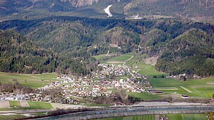
 View from the south of Baumkirchen |
||
| Source: Municipal data from Statistics Austria | ||
Baumkirchen is a municipality with 1270 inhabitants (as of January 1, 2020) in the Innsbruck-Land district in Tyrol ( Austria ). The municipality is located in the judicial district of Hall in Tirol .
geography
Baumkirchen is located in the Inn valley , north of the Inn , on the slope of the Gnadenwald terrace . The main town is at the exit of the Baumkirchner valley , which the Fallbach flows through. The Unterfeld settlement is located about one kilometer southwest of the main town .
The community can be reached via the Inntal Autobahn and the Unterinntalbahn with the Volders-Baumkirchen stop .
Neighboring communities
Neighboring communities of Baumkirchen are:
history
Baumkirchen was mentioned for the first time around 1147 in a disposition in favor of the St. Peter monastery in Salzburg as "Poumchirche". A mention in a deed of donation from 1040 as Pawinuchircha is said to refer to a Baumkirchen which today belongs to Munich . In 1312 Baumkirchen is listed as a separate municipality in the Inntaler tax book . As Franz Fliri, a geography professor who lives in Baumkirchen at the University of Innsbruck, writes in his book about Baumkirchen, the Laurentius church patronage, the field names with their partly Romanesque origins and the division of the hallway indicate that the Baumkirchen settlement is older than the first documented one Mention.
The Baumkirchen parish church was verifiably consecrated for the first time in 1310 by Bishop Johann von Brixen , but according to Fliri, the Laurentius patronage indicates a higher age. In 1490 Paul Heuberger built the Wohlgemutsheim Palace in Baumkirchen . The castle changed hands several times and from 1623 to 1783 it belonged to the Haller Damenstift . Don Bosco sisters have been housed in the castle since 1959 . The palace chapel of the Holy Trinity is said to have been built around 1517 by Paul von Kripp with the patronage of the 14 helpers in need. 1650 was the Kreuzbühel from the Haller common citizen Thomas Gapp with other benefactors, the Anna Chapel built. The construction took place in the style of the buildings by Hippolyt Guarinoni and was endowed by Johann Karl von Fieger with endowment funds. The chapel gained special importance through the St. Anna Brotherhood, which was founded in 1710 and which at the time of its foundation comprised almost half the population of Baumkirchen. Also around the middle of the 17th century, in the area of a healing spring that Hippolyt Guarinoni is said to have discovered, a bath house with a spa was built, which was maintained until the time before the Second World War . After 1939 the bath house was only used for apartments and was demolished in 1984. The springs below the Anna chapel were destroyed by road construction in 1950.
Population development

politics
The last mayoral elections took place at the same time as the municipal council elections on February 28, 2016. Only one party stood for election, Josef Schindl was elected mayor as in the 2010 elections.
| Political party | percent | be right | Seats on the local council |
|---|---|---|---|
| Common village list ÖVP | 100% | 534 | 13 |
coat of arms
Blazon : In a divided shield above a deciduous tree with green leaves on a white background, a white church below on a red background.
The coat of arms was awarded on April 21, 1949. As a talking coat of arms, it symbolizes the place name.
Culture and sights
literature
- Franz Fliri: Baumkirchen, local history of a village in Tyrol. Fliri Verlag 1999.
Web links
- 70305 - Baumkirchen. Community data, Statistics Austria .
- Tyrol Atlas
- Baumkirchen , in the history database ofthe association "fontes historiae - sources of history"
- www.baumkirchen.tirol.gv.at Baumkirchen
- Baumkirchen municipality: Official website of the municipality in the Hall-Wattens tourist region
Individual evidence
- ↑ Martin Bitschnau , Hannes Obermair : Tiroler Urkundenbuch, II. Department: The documents on the history of the Inn, Eisack and Pustertal valleys. Vol. 2: 1140-1200 . Universitätsverlag Wagner, Innsbruck 2012, ISBN 978-3-7030-0485-8 , p. 53-54, no. 433 .
- ^ Franz Fliri: Baumkirchen. Local history of a village in Tyrol . 2nd expanded edition. Self-published, Baumkirchen 1999.
- ↑ Baumkirchen community . Wahlen.tirol.gv.at. Retrieved May 8, 2016.


