
Schmirn
|
Schmirn
|
||
|---|---|---|
| coat of arms | Austria map | |
 |
|
|
| Basic data | ||
| Country: | Austria | |
| State : | Tyrol | |
| Political District : | Innsbruck country | |
| License plate : | IL | |
| Main town : | Outrageous | |
| Surface: | 62.59 km² | |
| Coordinates : | 47 ° 5 ' N , 11 ° 34' E | |
| Height : | 1407 m above sea level A. | |
| Residents : | 875 (January 1, 2020) | |
| Population density : | 14 inhabitants per km² | |
| Postal code : | 6154 | |
| Area code : | 05279 | |
| Community code : | 7 03 49 | |
| NUTS region | AT332 | |
| Address of the municipal administration: |
Schmirn 58b 6154 Schmirn |
|
| Website: | ||
| politics | ||
| Mayor : | Vinzenz Eller (general list) | |
|
Municipal Council : (2016) (11 members) |
||
| Location of Schmirn in the Innsbruck-Land district | ||
  |
||
 Insight into the Schmirntal |
||
| Source: Municipal data from Statistics Austria | ||


Schmirn is a municipality with 875 inhabitants (as of January 1, 2020) in the Innsbruck-Land district in Tyrol ( Austria ). The municipality is located in the judicial district of Innsbruck .
location
Schmirn is located in the Schmirntal , an eastern side valley of the Wipptal . The municipality stretches from St. Jodok to the ridge of the Tux Alps in the north, in the southeast to the Tux ridge of the Zillertal Alps with the 3476 m high Olperer and in the south to the Vals ridge .
The settlement area is characterized by scattered Rotten , hamlets and individual farms , with the Schmirn district being the center of the community. The southern part of St. Jodok belongs to the municipality of Vals .
The valley is traversed by the Schmirnbach, which flows into the Valser Bach in St. Jodok .
Community structure
|
structure
|
||||||
|
Legend for the breakdown table
|
The municipality includes the following two localities (population in brackets as of January 1, 2020):
- Ausserschmirn (703)
- Inner Schmirn (172)
Neighboring communities
- Finkenberg ,
- Navigation systems ,
- Steinach am Brenner ,
- Tux ,
- Vals ,
- Wattenberg .
history
Schmirn was first mentioned in 1249 as Vallis Smurne and has been an independent municipality since 1811.
From Kasern at the end of the Schmirntal the path leads over the Tuxer Joch to Hintertux , which until 1926 belonged to the community of Schmirn.
In 2012 Schmirn was added to the list of “mountaineering villages” of the Austrian Alpine Club.
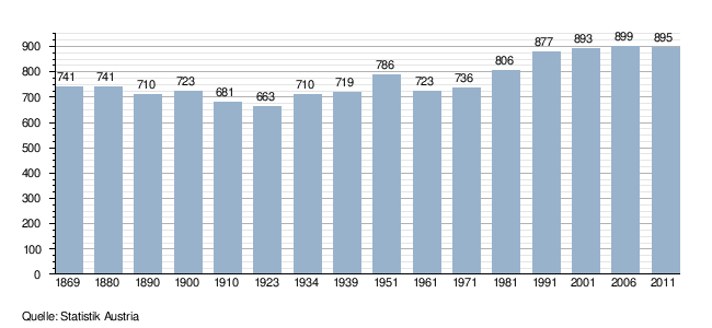
Population development
politics
The last mayoral elections took place at the same time as the municipal council elections on February 28, 2016.
Vinzenz Eller was elected mayor. He was the only candidate.
Culture and sights
Economy and Infrastructure
Agriculture is characterized by small businesses and is mainly operated as a sideline, there are many commuters in the valley.
The community has a connection to the railroad via the St. Jodok stop of the Brennerbahn .
societies
- Schmirn music band
- Sports club Schmirn
- Mixed choir Schmirn
- Schmirn men's choir
- Schmirn rifle company
- Schmirn volunteer fire brigade
- Schmirn young farmers
Web links
- Schmirn , in the history database ofthe association "fontes historiae - sources of history"
Individual evidence
- ↑ Statistics Austria: Population on January 1st, 2020 by locality (area status on January 1st, 2020) , ( CSV )
- ↑ Mountaineering Villages
- ↑ Local council and mayoral elections 2016 | Schmirn community. In: Wahlen.tirol.gv.at. State of Tyrol, accessed on September 13, 2016 .
City: Hall in Tirol . Market communities: Fulpmes • Matrei am Brenner • Steinach am Brenner • Völs • Wattens • Zirl . Municipalities: Absam • Aldrans • Ampass • Axams • Baumkirchen • Birgitz • Ellbögen • Flaurling • Fritzens • Gnadenwald • Götzens • Gries am Brenner • Gries im Sellrain • Grinzens • Gschnitz • Hatting • Inzing • Kematen in Tirol • Kolsass • Kolsassberg • Lans • Leutasch • Mieders • Mils • Mühlbachl • Mutters • Natters • Navis • Neustift im Stubaital • Oberhofen im Inntal • Obernberg am Brenner • Oberperfuss • Patsch • Pettnau • Pfaffenhofen • Pfons • Polling in Tirol • Ranggen • Reith bei Seefeld • Rinn • Rum • St. Sigmund im Sellrain • Scharnitz • Schmirn • Schönberg im Stubaital • Seefeld in Tirol • Sellrain • Sistrans • Telfes im Stubai • Telfs • Thaur • Trins • Tulfes • Unterperfuss • Vals • Volders • Wattenberg • Wildermieming .