
Brennerbahn
| Innsbruck – Bolzano – Verona | |||||||||||||||||||||||||||||||||||||||||||||||||||||||||||||||||||||||||||||||||||||||||||||||||||||||||||||||||||||||||||||||||||||||||||||||||||||||||||||||||||||||||||||||||||||||||||||||||||||||||||||||||||||||||||||||||||||||||||||||||||||||||||||||||||||||||||||||||||||||||||||||||||||||||||||||||||||||||||||||||||||||||||||||||||||||||||||||||||||||||||||||||||||||||||||||||||||||||||||||||||||||||||||||||||||||||||||||||||||||||||||||||||||||||||||||||||||||||||||||||||||||||||||||||||||||||||||||||||||||||||||||||||||||||||||||||||||||||||||||||||||||||||||||||||||||||||||||||||||||||||||||||||||||||||||
|---|---|---|---|---|---|---|---|---|---|---|---|---|---|---|---|---|---|---|---|---|---|---|---|---|---|---|---|---|---|---|---|---|---|---|---|---|---|---|---|---|---|---|---|---|---|---|---|---|---|---|---|---|---|---|---|---|---|---|---|---|---|---|---|---|---|---|---|---|---|---|---|---|---|---|---|---|---|---|---|---|---|---|---|---|---|---|---|---|---|---|---|---|---|---|---|---|---|---|---|---|---|---|---|---|---|---|---|---|---|---|---|---|---|---|---|---|---|---|---|---|---|---|---|---|---|---|---|---|---|---|---|---|---|---|---|---|---|---|---|---|---|---|---|---|---|---|---|---|---|---|---|---|---|---|---|---|---|---|---|---|---|---|---|---|---|---|---|---|---|---|---|---|---|---|---|---|---|---|---|---|---|---|---|---|---|---|---|---|---|---|---|---|---|---|---|---|---|---|---|---|---|---|---|---|---|---|---|---|---|---|---|---|---|---|---|---|---|---|---|---|---|---|---|---|---|---|---|---|---|---|---|---|---|---|---|---|---|---|---|---|---|---|---|---|---|---|---|---|---|---|---|---|---|---|---|---|---|---|---|---|---|---|---|---|---|---|---|---|---|---|---|---|---|---|---|---|---|---|---|---|---|---|---|---|---|---|---|---|---|---|---|---|---|---|---|---|---|---|---|---|---|---|---|---|---|---|---|---|---|---|---|---|---|---|---|---|---|---|---|---|---|---|---|---|---|---|---|---|---|---|---|---|---|---|---|---|---|---|---|---|---|---|---|---|---|---|---|---|---|---|---|---|---|---|---|---|---|---|---|---|---|---|---|---|---|---|---|---|---|---|---|---|---|---|---|---|---|---|---|---|---|---|---|---|---|---|---|---|---|---|---|---|---|---|---|---|---|---|---|---|---|---|---|---|---|---|---|---|---|---|---|---|---|---|---|---|---|---|---|---|---|---|---|---|---|---|---|---|---|---|---|---|---|---|---|---|---|---|---|---|---|---|---|---|---|---|---|---|---|---|---|---|---|---|---|---|---|---|---|---|---|---|---|---|---|---|---|---|---|---|---|---|---|---|---|---|---|---|---|---|---|---|---|---|---|---|---|---|---|---|---|---|---|---|---|---|---|---|---|---|---|---|---|---|---|---|---|---|---|---|---|---|---|---|---|---|---|---|---|---|---|---|---|---|---|---|---|---|---|---|---|---|---|---|---|---|---|---|---|---|---|---|---|---|---|---|---|---|---|---|---|---|---|---|---|---|---|---|---|---|---|---|---|---|---|---|---|---|---|---|---|---|---|---|---|---|---|---|---|---|---|---|---|---|---|---|---|---|---|---|---|---|---|---|---|---|---|---|---|---|---|---|---|---|---|---|---|---|---|---|---|---|---|---|---|---|---|---|---|---|---|
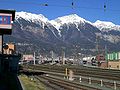
 A Eurocity at Matrei am Brenner.
| |||||||||||||||||||||||||||||||||||||||||||||||||||||||||||||||||||||||||||||||||||||||||||||||||||||||||||||||||||||||||||||||||||||||||||||||||||||||||||||||||||||||||||||||||||||||||||||||||||||||||||||||||||||||||||||||||||||||||||||||||||||||||||||||||||||||||||||||||||||||||||||||||||||||||||||||||||||||||||||||||||||||||||||||||||||||||||||||||||||||||||||||||||||||||||||||||||||||||||||||||||||||||||||||||||||||||||||||||||||||||||||||||||||||||||||||||||||||||||||||||||||||||||||||||||||||||||||||||||||||||||||||||||||||||||||||||||||||||||||||||||||||||||||||||||||||||||||||||||||||||||||||||||||||||||||
 | |||||||||||||||||||||||||||||||||||||||||||||||||||||||||||||||||||||||||||||||||||||||||||||||||||||||||||||||||||||||||||||||||||||||||||||||||||||||||||||||||||||||||||||||||||||||||||||||||||||||||||||||||||||||||||||||||||||||||||||||||||||||||||||||||||||||||||||||||||||||||||||||||||||||||||||||||||||||||||||||||||||||||||||||||||||||||||||||||||||||||||||||||||||||||||||||||||||||||||||||||||||||||||||||||||||||||||||||||||||||||||||||||||||||||||||||||||||||||||||||||||||||||||||||||||||||||||||||||||||||||||||||||||||||||||||||||||||||||||||||||||||||||||||||||||||||||||||||||||||||||||||||||||||||||||||
| Route number (ÖBB) : | 302 02 | ||||||||||||||||||||||||||||||||||||||||||||||||||||||||||||||||||||||||||||||||||||||||||||||||||||||||||||||||||||||||||||||||||||||||||||||||||||||||||||||||||||||||||||||||||||||||||||||||||||||||||||||||||||||||||||||||||||||||||||||||||||||||||||||||||||||||||||||||||||||||||||||||||||||||||||||||||||||||||||||||||||||||||||||||||||||||||||||||||||||||||||||||||||||||||||||||||||||||||||||||||||||||||||||||||||||||||||||||||||||||||||||||||||||||||||||||||||||||||||||||||||||||||||||||||||||||||||||||||||||||||||||||||||||||||||||||||||||||||||||||||||||||||||||||||||||||||||||||||||||||||||||||||||||||||||
| Route number (RFI) : | 42 (Brenner - Bozen) 43 (Bozen - Verona) |
||||||||||||||||||||||||||||||||||||||||||||||||||||||||||||||||||||||||||||||||||||||||||||||||||||||||||||||||||||||||||||||||||||||||||||||||||||||||||||||||||||||||||||||||||||||||||||||||||||||||||||||||||||||||||||||||||||||||||||||||||||||||||||||||||||||||||||||||||||||||||||||||||||||||||||||||||||||||||||||||||||||||||||||||||||||||||||||||||||||||||||||||||||||||||||||||||||||||||||||||||||||||||||||||||||||||||||||||||||||||||||||||||||||||||||||||||||||||||||||||||||||||||||||||||||||||||||||||||||||||||||||||||||||||||||||||||||||||||||||||||||||||||||||||||||||||||||||||||||||||||||||||||||||||||||
| Course book route (ÖBB) : | 300 (Salzburg Hbf - Brennero / Brenner) 301 (Jenbach - Telfs-Pfaffenhofen / Steinach in Tirol) |
||||||||||||||||||||||||||||||||||||||||||||||||||||||||||||||||||||||||||||||||||||||||||||||||||||||||||||||||||||||||||||||||||||||||||||||||||||||||||||||||||||||||||||||||||||||||||||||||||||||||||||||||||||||||||||||||||||||||||||||||||||||||||||||||||||||||||||||||||||||||||||||||||||||||||||||||||||||||||||||||||||||||||||||||||||||||||||||||||||||||||||||||||||||||||||||||||||||||||||||||||||||||||||||||||||||||||||||||||||||||||||||||||||||||||||||||||||||||||||||||||||||||||||||||||||||||||||||||||||||||||||||||||||||||||||||||||||||||||||||||||||||||||||||||||||||||||||||||||||||||||||||||||||||||||||
| Course book series (IT) : | 50 | ||||||||||||||||||||||||||||||||||||||||||||||||||||||||||||||||||||||||||||||||||||||||||||||||||||||||||||||||||||||||||||||||||||||||||||||||||||||||||||||||||||||||||||||||||||||||||||||||||||||||||||||||||||||||||||||||||||||||||||||||||||||||||||||||||||||||||||||||||||||||||||||||||||||||||||||||||||||||||||||||||||||||||||||||||||||||||||||||||||||||||||||||||||||||||||||||||||||||||||||||||||||||||||||||||||||||||||||||||||||||||||||||||||||||||||||||||||||||||||||||||||||||||||||||||||||||||||||||||||||||||||||||||||||||||||||||||||||||||||||||||||||||||||||||||||||||||||||||||||||||||||||||||||||||||||
| Route length: | 275.4 km | ||||||||||||||||||||||||||||||||||||||||||||||||||||||||||||||||||||||||||||||||||||||||||||||||||||||||||||||||||||||||||||||||||||||||||||||||||||||||||||||||||||||||||||||||||||||||||||||||||||||||||||||||||||||||||||||||||||||||||||||||||||||||||||||||||||||||||||||||||||||||||||||||||||||||||||||||||||||||||||||||||||||||||||||||||||||||||||||||||||||||||||||||||||||||||||||||||||||||||||||||||||||||||||||||||||||||||||||||||||||||||||||||||||||||||||||||||||||||||||||||||||||||||||||||||||||||||||||||||||||||||||||||||||||||||||||||||||||||||||||||||||||||||||||||||||||||||||||||||||||||||||||||||||||||||||
| Gauge : | 1435 mm ( standard gauge ) | ||||||||||||||||||||||||||||||||||||||||||||||||||||||||||||||||||||||||||||||||||||||||||||||||||||||||||||||||||||||||||||||||||||||||||||||||||||||||||||||||||||||||||||||||||||||||||||||||||||||||||||||||||||||||||||||||||||||||||||||||||||||||||||||||||||||||||||||||||||||||||||||||||||||||||||||||||||||||||||||||||||||||||||||||||||||||||||||||||||||||||||||||||||||||||||||||||||||||||||||||||||||||||||||||||||||||||||||||||||||||||||||||||||||||||||||||||||||||||||||||||||||||||||||||||||||||||||||||||||||||||||||||||||||||||||||||||||||||||||||||||||||||||||||||||||||||||||||||||||||||||||||||||||||||||||
| Power system : | 15 kV 16.7 Hz ÖBB ~ 3 kV RFI = |
||||||||||||||||||||||||||||||||||||||||||||||||||||||||||||||||||||||||||||||||||||||||||||||||||||||||||||||||||||||||||||||||||||||||||||||||||||||||||||||||||||||||||||||||||||||||||||||||||||||||||||||||||||||||||||||||||||||||||||||||||||||||||||||||||||||||||||||||||||||||||||||||||||||||||||||||||||||||||||||||||||||||||||||||||||||||||||||||||||||||||||||||||||||||||||||||||||||||||||||||||||||||||||||||||||||||||||||||||||||||||||||||||||||||||||||||||||||||||||||||||||||||||||||||||||||||||||||||||||||||||||||||||||||||||||||||||||||||||||||||||||||||||||||||||||||||||||||||||||||||||||||||||||||||||||
| Maximum slope : | North ramp: 25 ‰ South ramp: 22.5 ‰ |
||||||||||||||||||||||||||||||||||||||||||||||||||||||||||||||||||||||||||||||||||||||||||||||||||||||||||||||||||||||||||||||||||||||||||||||||||||||||||||||||||||||||||||||||||||||||||||||||||||||||||||||||||||||||||||||||||||||||||||||||||||||||||||||||||||||||||||||||||||||||||||||||||||||||||||||||||||||||||||||||||||||||||||||||||||||||||||||||||||||||||||||||||||||||||||||||||||||||||||||||||||||||||||||||||||||||||||||||||||||||||||||||||||||||||||||||||||||||||||||||||||||||||||||||||||||||||||||||||||||||||||||||||||||||||||||||||||||||||||||||||||||||||||||||||||||||||||||||||||||||||||||||||||||||||||
| Minimum radius : | 264 m | ||||||||||||||||||||||||||||||||||||||||||||||||||||||||||||||||||||||||||||||||||||||||||||||||||||||||||||||||||||||||||||||||||||||||||||||||||||||||||||||||||||||||||||||||||||||||||||||||||||||||||||||||||||||||||||||||||||||||||||||||||||||||||||||||||||||||||||||||||||||||||||||||||||||||||||||||||||||||||||||||||||||||||||||||||||||||||||||||||||||||||||||||||||||||||||||||||||||||||||||||||||||||||||||||||||||||||||||||||||||||||||||||||||||||||||||||||||||||||||||||||||||||||||||||||||||||||||||||||||||||||||||||||||||||||||||||||||||||||||||||||||||||||||||||||||||||||||||||||||||||||||||||||||||||||||
| Top speed: | 180 km / h | ||||||||||||||||||||||||||||||||||||||||||||||||||||||||||||||||||||||||||||||||||||||||||||||||||||||||||||||||||||||||||||||||||||||||||||||||||||||||||||||||||||||||||||||||||||||||||||||||||||||||||||||||||||||||||||||||||||||||||||||||||||||||||||||||||||||||||||||||||||||||||||||||||||||||||||||||||||||||||||||||||||||||||||||||||||||||||||||||||||||||||||||||||||||||||||||||||||||||||||||||||||||||||||||||||||||||||||||||||||||||||||||||||||||||||||||||||||||||||||||||||||||||||||||||||||||||||||||||||||||||||||||||||||||||||||||||||||||||||||||||||||||||||||||||||||||||||||||||||||||||||||||||||||||||||||
|
|||||||||||||||||||||||||||||||||||||||||||||||||||||||||||||||||||||||||||||||||||||||||||||||||||||||||||||||||||||||||||||||||||||||||||||||||||||||||||||||||||||||||||||||||||||||||||||||||||||||||||||||||||||||||||||||||||||||||||||||||||||||||||||||||||||||||||||||||||||||||||||||||||||||||||||||||||||||||||||||||||||||||||||||||||||||||||||||||||||||||||||||||||||||||||||||||||||||||||||||||||||||||||||||||||||||||||||||||||||||||||||||||||||||||||||||||||||||||||||||||||||||||||||||||||||||||||||||||||||||||||||||||||||||||||||||||||||||||||||||||||||||||||||||||||||||||||||||||||||||||||||||||||||||||||||
The burner web ( Italian Ferrovia Brennero ) was 1864 to 1867 according to the plans and under the direction of Karl Etzel from the kk priv. Südbahngesellschaft as part of the compound of Kufstein by Ala (and further in the direction of Verona built). The section with the crossing of the main Alpine ridge from Innsbruck via the Brenner Pass and Bolzano to Verona is known as the Brenner Railway . The Brenner Railway starts in North Tyrol , crosses South Tyrol and Trentino and ends in Veneto . The route runs through the Wipptal , Eisack and Etschtal valleys . The Brenner Railway is part of the Berlin – Palermo railway axis . As part of the planning of the Brenner Base Tunnel including the access routes, extensive sections are to be supplemented with new tunnels.
history
As early as 1836, Franz Xaver Riepl envisaged a connection from the Bavarian region via Kufstein, Innsbruck, the Brenner and Bozen to Verona in his plan for a nationwide railway network.
On November 24, 1858, the Lower Inn Valley Railway was opened from the Bavarian border to Innsbruck. The line from Verona to Trento was opened on September 19, 1858. The section from Trento to Bolzano followed on May 17, 1859, completing the route through the Adige Valley. Closing the gap in the north-south connection via the Brenner was the obvious next step. The Semmering Railway , completed in 1854, had shown that railway construction in the mountains was technically possible.
Early 1860s the kk priv. Was Südbahngesellschaft with a decree Emperor Franz Joseph I with the construction of the Brenner Railway commissioned. The technical management was entrusted to Karl Etzel. In May 1861 the preparatory work began, in the course of 1863 Etzel's project was approved by the Ministry of Commerce and the detailed projects and cost calculations as well as surveying work were completed. The first groundbreaking took place on February 23, 1864 at the Bergisel tunnel. Achilles Thommen was responsible as site manager for the alignment and construction . After Etzel's death in 1865, he and Wilhelm Pressel managed the completion of the railway. For the first time in railway construction, spiral tunnels were used. The construction, which was completed in just three and a half years, employed up to 20,600 workers, mainly from Welschtirol and Italy as well as from Slovenia and Croatia.
On May 8, 1867, the first locomotive drove through the Bergisel Tunnel, on July 12, the last major building structure, the Kardauner Bridge, was completed and on July 25, a test train drove through the entire route from Innsbruck to Bozen. The route was opened for freight traffic on August 17th and for passenger traffic on August 24th. Due to the court mourning for the shot Emperor Maximilian of Mexico , the release took place without any celebrations.
The entire route was built for double-track operation from the start, but initially only one track was laid for cost reasons. The expansion began soon, as early as the spring of 1868 the line from Innsbruck to the Brenner Pass was open on two tracks, only in 1908.
In 1866 the formerly Austrian Veneto fell to Italy and Ala became a border station. With the completion of the Pustertalbahn in 1871 and the Bozen-Meraner Bahn in 1880, the Franzensfeste and Bozen train stations became transfer stations.
In 1899 there were plans to connect the Stubai Valley with a branch line. It should branch off at the Stephansbrücke , lead via Telfes to Fulpmes and connect to the Brennerbahn via Mieders and Schönberg near Matrei . Instead, the Stubai Valley was connected to Innsbruck by the meter-gauge Stubai Valley Railway , built between 1901 and 1904 , and the Brennerbahn remained without side routes in what is now Austrian territory.

The First World War brought about the division of the historic County of Tyrol . The Trentino and South Tyrol were annexed by Italy, making the Brenner train station a border station. On August 1, 1919, the Ferrovie dello Stato took over the section south of the Brenner Pass , which until then had been under the private management of the Southern Railway Company. In 1923 the Austrian Federal Railways took over the section north of the Brenner Pass. In 1928–1929, the two railway companies provided extensive electrification of the Brenner Railway with different traction current systems. The Austrians installed single-phase alternating current (15 kV 16⅔ Hz) for the section Innsbruck - Brennersee , the Italians used three-phase current (3.6 kV 16⅔ Hz) for the section Bolzano - Brenner . It was not until 1934 that the Austrians were allowed to move their lines from the Brennersee train station to the Brenner train station on Italian territory, thus completely completing the electrification.
In the first Austrian republic , the part of the route located in Austria belonged to the area of responsibility of the Federal Railway Directorate Innsbruck . After Austria was annexed in 1938, it operated briefly as the Innsbruck Railway Directorate before it was dissolved on July 15, 1938. The route was subordinated to the Reichsbahndirektion Munich . After 1945 the ÖBB was re-established, the management structure from the time before 1938 was re-established, including the Federal Railway Directorate Innsbruck.
In 1941 the Italian state railways switched the route between Verona and Trento to 3 kV direct current , followed in 1952 by the section from Trento to Bozen and in 1965 that from Bozen to Brenner. Between 1944 (closure of the military station in Franzensfeste) and 2004, 20 train stations and stops were closed on the Italian side, 15 of them north of Bolzano. Continuous electrical operation on the Austrian and Italian sides without changing locomotives in the Brenner station was made possible for the first time in 1993 by the two-system locomotives ÖBB 1822 .
Since the 1990s there has been increased investment in the structural infrastructure: in 1994 the 14.7 km long Innsbruck freight train bypass and the 13.3 km long Schlern tunnel went into operation. In 1998 the opening of the new Cerainotunnel near the Veronese Klause and the 3.9 km long Kardaun tunnel were celebrated, inside which the caverns for a future bypass of Bolzano have already been considered. In 1999 the 7.3 km long Pflersch tunnel replaced the old Aster tunnel . A rockfall gallery was built between Mattarello and Calliano , and the railway line at Klausen and Waidbruck was built in to protect against noise. In the 2000s, all level crossings could be replaced in order to increase safety. Some train stations have been converted into stops.
On August 3, 2006, the SCMT train control system was activated on the Italian side. In the summer of 2012 a general renovation of the route was carried out on the Austrian side.
Expansion and expansion plans
The Brenner Base Tunnel has been under construction since 2007 and will result in a significant increase in capacity and speed on the Brenner route, which is part of the Berlin-Palermo railway axis. The tunnel from Innsbruck to Franzensfeste will be 55 km long, including the Innsbruck bypass even 64 km. Commissioning is planned for the year 2028. At the same time, additional access routes are planned on the southern ramp of the Brenner Railway, including tunnels on the Franzensfeste – Waidbruck route.
Routing

.jpg)
The Brennerbahn represents a part of an important railway connection between Germany and Italy , it connects Munich via Innsbruck with Verona on the shortest route.
The maximum gradient of the route is 25 ‰ on the north and 22.5 ‰ on the south ramp. The minimum curve radii are 264 meters. For the first time, spiral tunnels were built to overcome the 796 meters of altitude from Innsbruck to the Brenner. The apex of the Brennerbahn lies at 1,371 m above sea level at the Brenner station and is the highest point in the ÖBB's standard gauge network . Along the north ramp there are no less than 14 smaller tunnels with a total length of 3550 meters.
From Innsbruck, where the Arlbergbahn branches off to the west, the Brennerbahn heads south. She drives through the Bergisel through a tunnel and then enters the Wipptal along the Sill Gorge . Passing the Unterberg and Patsch stations , it goes to Matrei and from there to Steinach. At Vals - St. Jodok , the Brennerbahn gains height through a bend , it crosses the Schmirntal and Valsertal and climbs up the mountainside. Next comes the Gries station , under overhanging cliffs it goes to the Brennersee station , where the A13 Brenner autobahn comes close to the Brennerbahn.
At the Brenner border station , the separation point between the two power systems is roughly in the middle of the platform. In the Brenner train station there is a monument to the builder of the Brenner Railway, Karl von Etzel .
The route then leads downhill to the former Brennerbad station , where it branches off into the Pflersch tunnel , which was newly built in 1999 . From Gossensaß the route goes down to Sterzing and Franzensfeste , where the Pustertalbahn branches off. This is followed by the section with the steepest gradient from Franzensfeste to Brixen . The further course through the Eisack Valley to Bolzano no longer has any particular inclines. This section of the route was re-routed in the 1990s, with two longer tunnels being built.
South of Bolzano, the route runs in the broad bottom of the Adige Valley and therefore has almost no major engineering structures. The bridges for crossing the Adige and its tributaries are an exception . Immediately after the Mezzocorona train station , the Non Valley Railway , which runs parallel from here, crosses the route. Finally, the railway line bypasses the Veronese Klause with a tunnel built in the 1990s . Shortly before entering the Verona Porta Nuova train station, take the San Massimo junction and join the track node, which will take you to Milan , Bologna or the Verona freight station.
Power supply system change at the Brenner train station
The power supply for the north ramp of the Brenner route is mainly ensured by the ÖBB power plant in Fulpmes , which uses Ruetz's energy and supplies 16 MW.
In 1928 the entire Brenner station was electrified with the Italian "Trifase" three-phase system. The BBÖ at that time were not allowed to lay the single-phase AC contact line as far as the station on Italian territory. She therefore built the Brennersee station , in which steam locomotives were harnessed for the short section Brennersee – Brenner. This costly operation lasted until 1934.
Since 1934, the Brenner station has been a classic system-changing station with transverse separation. A particular problem with the AC machines on the north side is that the cooling for the transformer and traction motors fails at the moment of the greatest heat development when the top is reached due to the necessary ironing. Classic multi-system locomotives were not only comparatively heavy, but were also noticeably less efficient, especially in the AC network, due to their design as DC voltage locomotives with resistance control and an upstream transformer with fixed transmission. That is why the single-system machines were changed at the Brenner train station for decades. For some years now, multi-system locomotives with low-loss three-phase drives have also been available. Their use failed for several years due to the lack of approval in the other country. In the beginning, for example, the machines classified as class 189 in Germany were not allowed to be moved under their own power in the DC area of the Brenner train station; later shunting was allowed. Several series are now allowed to run continuously, for example the ÖBB series 1216 machines equipped for traffic with Italy .
In 2013, the State of South Tyrol also procured two-system railcars for local transport, which enable continuous operation on the Brenner Railway to Innsbruck.
For terminating regional trains, there are butt tracks north and south of the station building on an island, which are spanned with the respective system. In order to keep the transfer routes short, the Trenitalia push-pull trains usually run on one of the continuous tracks. The locomotives parked at the southern end of the train thus remain under the DC contact line.
gallery
Innsbruck railway station track area

Taurus locomotive ready to leave Innsbruck

On the open stretch between Innsbruck and the Brenner Pass

189-917 at the Brenner train station

Shunting at the Brenner with an Italian E 405 locomotive

Butt siding for regional trains on the Brenner

East side of the Brenner train station

Remise at the Brenner train station

The characteristic clock tower at the Bolzano train station
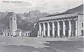
Facade of Bozen train station (approx. 1930)

The abandoned coach house at Bozen train station

Interior of the coach house at Bozen train station, which is still in use today


See also
literature
- MW: At the opening of the Brenner Railway . In: The Gazebo . Issue 45, 1867, pp. 720 ( full text [ Wikisource ] poem).
- Victor von Röll : Art. Brennerbahn . In: Enzyklopädie des Eisenbahnwesens , Volume 3. Berlin, Vienna 1912, pp. 62–65.
- Helmut K. Missbach: Railways in Tyrol. Prehistory - railway construction - operation . Motorbuch Verlag, Stuttgart 1979, ISBN 3-87943-640-1 , p. 27-55 .
- Elisabeth Baumgartner: Railway Landscape Old Tyrol . Transport history between Kufstein and Ala in the field of tension between tourism, politics and culture. Haymon-Verlag, Innsbruck 1990, ISBN 3-85218-065-1 .
- Laura Facchinelli: The Verona – Brenner Railway . History of an important transport route. Athesia, Bozen 1995, ISBN 88-7014-856-4 .
- Wittfrida Mitterer, u. a .: Points & Landmarks . Railway landscape Bozen Innsbruck. Ed .: Board of Trustees for Technical Cultural Assets. Athesia, Bozen 2007, ISBN 978-88-8266-440-4 .
- Günter Denoth: 150 years of railways in Tyrol . Sutton, Erfurt 2008, ISBN 978-3-86680-316-9 .
- Michael Alexander Populorum: Railway archaeological excursions south of the Brenner Pass - Part 1: On foot along the old Brenner route from Brenner to Gossensass. Series of publications by the Documentation Center for European Railway Research (DEEF), Volume 2, 2011, 3rd edition 2017 on DVD, ISBN 978-3-903132-07-8 . Mercurius Verlag Grödig / Salzburg. Railway Research Austria
- Michael Alexander Populorum: Railway archaeological excursions south of the Brenner Pass - Part 2: From Bozen to Waidbruck along the old Brenner route. Dedicated to Univ. Prof. Dr. Helmut Heuberger. Series of publications by the Documentation Center for European Railway Research (DEEF), Volume 4, 2012, 3rd edition 2017 on DVD, ISBN 978-3-903132-09-2 . Mercurius Verlag Grödig / Salzburg. Railway Research Austria
- Angela Jursitzka, Helmut Pawelka: Carl von Etzel. A life for the railroad , Tyrolia-Verlag, Innsbruck, Vienna, 2017, ISBN 978-3-7022-3598-7 .
- Hubert Held: The building history of the Brennerbahn 1836–1867: From Munich via old tyrol to Venice - from a political, economic and technical perspective. Innsbruck-Vienna-Bozen: StudienVerlag 2018, ISBN 978-3-706550987
Web links
- Köstlin: Unveiling of the Etzel monument. : Allgemeine Bauzeitung , year 1893, p. 5 (online at ANNO ).
- Action group Brennerbahn
- Brenner Base Tunnel Society
- Pflerschtal railway line - photographic off-road tour
- AlpenTunnel.de - Video of a steam ride over the north ramp
- The railway line Bolzano - Verona (South Tyrolean Railway / Etschtalbahn)
Individual evidence
- ^ Impianti FS. In: I Treni No. 273 (September 2005), p. 8.
- ^ Impianti FS. In: I Treni No. 283 (July 2006), p. 11.
- ^ Impianti FS. In: I Treni No. 264 (November 2004), p. 5.
- ↑ Video 21:40 - 22:42 accessed on February 9, 2016
- ^ Impianti FS. In: I Treni No. 252 (October 2003), p. 8.
- ^ Impianti FS. In: I Treni No. 267 (February 2005), pp. 6-7.
- ^ Impianti FS. In: I Treni No. 262 (September 2004), p. 6.
- ^ Impianti FS. In: I Treni No. 266 (January 2005), p. 9.
- ↑ Deutsche Reichsbahn-Gesellschaft (Ed.): Official Gazette of the Reichsbahndirektion Mainz of August 6, 1938, No. 36. Announcement No. 488, p. 213.
- ↑ Elevation profile of the Brennerbahn Fig. 79 from: Enzyklopädie des Eisenbahnwesens , Ed. Viktor Dr. Baron v. Röll. 2nd, completely revised edition, 1912–1923 (1924), 10 volumes. - With the designation of the water stations, i.e. stations with water supply for steam locomotives.
Berlin – Bitterfeld – Halle | Bitterfeld – Leipzig | Halle / Leipzig – Erfurt | Erfurt – Nuremberg | Nuremberg – Munich | Munich – Rosenheim | Rosenheim – Kufstein | Kufstein – Wörgl | Wörgl – Innsbruck | Innsbruck bypass | Brenner base tunnel | Franzensfeste – Verona | Milan / Verona – Bologna | Bologna – Florence | Florence – Rome | Rome – Naples | Naples – Salerno | Salerno – Reggio di Calabria | Bridge over the Strait of Messina | Messina – Fiumetorto | Fiumetorto – Palermo
Railways (standard gauge), in operation: Kufstein – Innsbruck | Innsbruck – Verona | Innsbruck – Bludenz | Innsbruck – Garmisch-Partenkirchen | Garmisch-Partenkirchen – Reutte – Kempten | Innsbruck bypass | not carried out: Landeck – Mals | under construction / planning: Grafing – Innsbruck (HLS) | Brenner base tunnel
Railways (narrow gauge), in operation: Innsbruck – Fulpmes | Innsbruck – Igls (today part of the Innsbruck tram) | Jenbach – Mayrhofen (Zillertal Railway) | Kiefersfelden – Wachtl | set: Kufstein – Schwoich
Trams, in operation: Innsbruck tram | (Narrow gauge), discontinued: Innsbruck – Hall iT
Cogwheel and funicular railways: Jenbach – Seespitz | Hungerburgbahn | Old Hungerburgbahn | Kaiser Maximilian Panorama Railway | Olympic track

Adhesion membranes in operation: Bozen – Meran | Brennerbahn | Drautalbahn | Pustertalbahn | Renon Railway | Vinschgau Railway
Discontinued adhesion webs: Dolomitenbahn | Fiemme Valley Railway | Val Gardena Railway | Lana – Meran | Tramway Bolzano | Tram Merano | Tauferer Bahn | Überetscher Bahn
Cogwheel and funicular railways : Ferata Gran Risa | Gardena Ronda Express | Guntschnabahn | Lasa marble run | Mendelbahn | Raschötzer Bahn | Renon Railway | Schneebergbahn | Virglbahn
Coordinates: 46 ° 18 ′ 26 ″ N , 11 ° 14 ′ 51 ″ E