
Dolomite Railway
| Toblach – Calalzo | |||||||||||||||||||||||||||||||||||||||||||||||||||||||||||||||||||||||||||||||||||||||||||||||||||||||||||||||||||||||||||||||||||||||||||||||||||||||||||||||||||||||||||||||||||||||||||||||||||||||||||||||||||||||||||||||||||||||||||||||||||||||||||||||||||||
|---|---|---|---|---|---|---|---|---|---|---|---|---|---|---|---|---|---|---|---|---|---|---|---|---|---|---|---|---|---|---|---|---|---|---|---|---|---|---|---|---|---|---|---|---|---|---|---|---|---|---|---|---|---|---|---|---|---|---|---|---|---|---|---|---|---|---|---|---|---|---|---|---|---|---|---|---|---|---|---|---|---|---|---|---|---|---|---|---|---|---|---|---|---|---|---|---|---|---|---|---|---|---|---|---|---|---|---|---|---|---|---|---|---|---|---|---|---|---|---|---|---|---|---|---|---|---|---|---|---|---|---|---|---|---|---|---|---|---|---|---|---|---|---|---|---|---|---|---|---|---|---|---|---|---|---|---|---|---|---|---|---|---|---|---|---|---|---|---|---|---|---|---|---|---|---|---|---|---|---|---|---|---|---|---|---|---|---|---|---|---|---|---|---|---|---|---|---|---|---|---|---|---|---|---|---|---|---|---|---|---|---|---|---|---|---|---|---|---|---|---|---|---|---|---|---|---|---|---|---|---|---|---|---|---|---|---|---|---|---|---|---|---|---|---|---|---|---|---|---|---|---|---|---|---|---|---|---|---|---|---|---|
 | |||||||||||||||||||||||||||||||||||||||||||||||||||||||||||||||||||||||||||||||||||||||||||||||||||||||||||||||||||||||||||||||||||||||||||||||||||||||||||||||||||||||||||||||||||||||||||||||||||||||||||||||||||||||||||||||||||||||||||||||||||||||||||||||||||||
| Route length: | 64.913 km | ||||||||||||||||||||||||||||||||||||||||||||||||||||||||||||||||||||||||||||||||||||||||||||||||||||||||||||||||||||||||||||||||||||||||||||||||||||||||||||||||||||||||||||||||||||||||||||||||||||||||||||||||||||||||||||||||||||||||||||||||||||||||||||||||||||
| Gauge : | 950 (partly also 700, 750 or 760) mm | ||||||||||||||||||||||||||||||||||||||||||||||||||||||||||||||||||||||||||||||||||||||||||||||||||||||||||||||||||||||||||||||||||||||||||||||||||||||||||||||||||||||||||||||||||||||||||||||||||||||||||||||||||||||||||||||||||||||||||||||||||||||||||||||||||||
| Power system : | 2700 V = | ||||||||||||||||||||||||||||||||||||||||||||||||||||||||||||||||||||||||||||||||||||||||||||||||||||||||||||||||||||||||||||||||||||||||||||||||||||||||||||||||||||||||||||||||||||||||||||||||||||||||||||||||||||||||||||||||||||||||||||||||||||||||||||||||||||
| Maximum slope : | 35 ‰ | ||||||||||||||||||||||||||||||||||||||||||||||||||||||||||||||||||||||||||||||||||||||||||||||||||||||||||||||||||||||||||||||||||||||||||||||||||||||||||||||||||||||||||||||||||||||||||||||||||||||||||||||||||||||||||||||||||||||||||||||||||||||||||||||||||||
| Minimum radius : | 70 m | ||||||||||||||||||||||||||||||||||||||||||||||||||||||||||||||||||||||||||||||||||||||||||||||||||||||||||||||||||||||||||||||||||||||||||||||||||||||||||||||||||||||||||||||||||||||||||||||||||||||||||||||||||||||||||||||||||||||||||||||||||||||||||||||||||||
| Deepest point: | 721 m slm (Calalzo Scalo) | ||||||||||||||||||||||||||||||||||||||||||||||||||||||||||||||||||||||||||||||||||||||||||||||||||||||||||||||||||||||||||||||||||||||||||||||||||||||||||||||||||||||||||||||||||||||||||||||||||||||||||||||||||||||||||||||||||||||||||||||||||||||||||||||||||||
| The highest point: | 1530 m slm (Im Gemärk / Cimabanche ) | ||||||||||||||||||||||||||||||||||||||||||||||||||||||||||||||||||||||||||||||||||||||||||||||||||||||||||||||||||||||||||||||||||||||||||||||||||||||||||||||||||||||||||||||||||||||||||||||||||||||||||||||||||||||||||||||||||||||||||||||||||||||||||||||||||||
| Installation: | June 1, 1921 (General Meeting since 1915) | ||||||||||||||||||||||||||||||||||||||||||||||||||||||||||||||||||||||||||||||||||||||||||||||||||||||||||||||||||||||||||||||||||||||||||||||||||||||||||||||||||||||||||||||||||||||||||||||||||||||||||||||||||||||||||||||||||||||||||||||||||||||||||||||||||||
| Decommissioning | May 17, 1964 Northern section: March 13, 1962 |
||||||||||||||||||||||||||||||||||||||||||||||||||||||||||||||||||||||||||||||||||||||||||||||||||||||||||||||||||||||||||||||||||||||||||||||||||||||||||||||||||||||||||||||||||||||||||||||||||||||||||||||||||||||||||||||||||||||||||||||||||||||||||||||||||||
| Regions (I): | Trentino-South Tyrol , Veneto | ||||||||||||||||||||||||||||||||||||||||||||||||||||||||||||||||||||||||||||||||||||||||||||||||||||||||||||||||||||||||||||||||||||||||||||||||||||||||||||||||||||||||||||||||||||||||||||||||||||||||||||||||||||||||||||||||||||||||||||||||||||||||||||||||||||
|
|||||||||||||||||||||||||||||||||||||||||||||||||||||||||||||||||||||||||||||||||||||||||||||||||||||||||||||||||||||||||||||||||||||||||||||||||||||||||||||||||||||||||||||||||||||||||||||||||||||||||||||||||||||||||||||||||||||||||||||||||||||||||||||||||||||
The Dolomitenbahn ( Italian Ferrovia delle Dolomiti ), also called Ampezzaner Bahn, was a narrow-gauge railway almost 65 kilometers long , which connected the villages of Toblach ( South Tyrol ) and Calalzo ( Veneto , Belluno province ). It thus represented a cross-connection between the standard-gauge Pustertalbahn and the also standard-gauge Belluno – Calalzo railway line , the most important and largest intermediate station of the railway was the well-known winter sports and Olympic resort of Cortina d'Ampezzo .
Today the long-distance cycle path of the Dolomites' Long Path runs along the route of the former railway .
history
The Dolomitenbahn was built in the course of the First World War to supply the units of the two combatants Austria-Hungary and Italy (who had been at war with each other since May 23, 1915) with material and supplies , which were then stationed on the front line there (so-called Dolomite Front ) to be able to supply. So initially there were two separate railway lines, both of which served exclusively military purposes.
From the north, the Austrian military built a motorized Heeresfeldbahn between the Pustertalbahn and the Höhlenstein Fortress (also Höhlenstein lock or Fort Höhlenstein, Italian: Landro ), which had been in existence since 1891, in 1915 ; it was designed with a 700 millimeter gauge and operated with gasoline locomotives . At the beginning of the First World War, however, this fortress was already completely out of date and was therefore disarmed on July 5, 1915, from then on Höhlenstein served as an infantry base and supply depot. The original Höhlenstein settlement, on the other hand, had already been evacuated and blown up at the beginning of the war in order to clear the field of fire expected in the event of war in the direction of the Cristallo group and Schluderbach (Italian: Carbonin ), so the field railway was only used to supply the military installations located there.
Starting from the south, Italy, the enemy of the war, also built a military field railway from Calalzo, but it was built with a gauge of 750 millimeters and operated with steam locomotives. This railway led up the Cadore towards the state border with Austria-Hungary (which at that time ran south of Cortina, at what is now the hamlet and former “Dogana Vecchia” stop - the Ladin and Italian-speaking area around Cortina was still part of Tyrol at that time.
With the advance of the Austrian military towards the south (collapse of the Italian Dolomite front in autumn 1917), the two railway lines were connected with each other in the course of 1917 under Austrian direction (gap closure over the Im Gemärk pass and connection to Cortina d'Ampezzo), simultaneously The two existing sections of 700 millimeters (Austrian section) and 750 millimeters (Italian section) were also re- tracked to the so-called Bosnian gauge of 760 millimeters, which is widely used in Austria-Hungary (the new section over the pass and through the Valle d 'Ampezzo, on the other hand, was designed in this gauge from the start). The now continuous line was temporarily completely under Austrian control and served to supply the Austrian front at Belluno .
On November 3, 1918, the two war opponents Austria-Hungary and Italy finally agreed the armistice at Villa Giusti . As a result, Italian troops occupied not only the previously lost areas in their own country (relating to the Dolomite Railway, i.e. the Cadore), but also parts of Tyrol , namely Welschtirol (today's autonomous province of Trento) and South Tyrol (today's autonomous province of Bolzano - South Tyrol).
From then on, the entire Dolomitenbahn was under Italian (military) occupation (South Tyrol and the area around Cortina initially belonged to the province of Trento. Cortina was then added to the province of Belluno in Veneto in 1923). With the Treaty of Saint-Germain (signed on September 10, 1919, entered into force on July 16, 1920), the two later provinces of Trento and Bozen then officially became part of Italy.
With a view to the planned commencement of civil passenger traffic, the Dolomitenbahn was re-gauged again in the years 1919 to 1921, this time to 950 millimeters (also called Italian meter gauge) and finally started operation on June 1, 1921 (initially exclusively steam operation ). All of the work involved had to be financed by Austria as reparations (under the Treaty of Saint-Germain).
In contrast to the earlier field railway, the new 950-millimeter line in the north has now been linked to the Pustertalbahn at Toblach station, the old route of the military field railway to Niederdorf, built in 1915, was abandoned after the First World War.
Route
The northern starting point of the train was the Toblach station on the Pustertalbahn , which is located a little south in the district of Neu-Toblach ( Dobbiaco Nuovo ) and thus outside the eponymous town. While the Pustertalbahn runs in an east-west direction, the Dolomitenbahn turned south immediately after the start of the route and followed the Höhlensteintal uphill. First it passed the Dobbiaco Lake , then the Nasswand military cemetery ( Sorgenti ), the Höhlenstein fortress ( Landro ) and the Dürrensee ( Lago di Landro ). From Schluderbach ( Carbonin ), a steeper ramp began for the railway up to the Im Gemärk pass ( Passo Cimabanche ), where the route reached its highest point.
About one kilometer before the culmination point, it also passed the district border between the now autonomous region of Trentino-South Tyrol and the Veneto region. This is also the provincial border between the autonomous province of Bolzano - South Tyrol and the province of Belluno. It also represents the regional language border between the Italian language and the German language . As a result, bilingual station names were used on the Dolomitenbahn north of the language border, but only the Italian names south of it.
On the populated top of the pass, in the area of the culmination point, there was also a train station, which served to develop the hamlet of Cimabanche and as a crossing station . From there the train followed the valley run of the Valle d'Ampezzo on to Cortina d'Ampezzo, the largest and most famous town on the route, from here steadily downwards. Between Acquabona and Chiapuzza, the route passes the hamlet of Dogana Vecchia (German: "Old Border"), the former state border between Austria-Hungary and Italy, which existed until July 16, 1920. From there it turns in an easterly direction.
Via San Vito it finally led around the Cadore further down the valley, including two shorter counter-climbs, to finally reach the end point Calalzo on Lago di Cadore. There was a connection to the standard gauge line of Trenitalia, which is still in operation today, in the direction of Belluno and Treviso .
Alignment
The route of the Dolomitenbahn was planned very elaborately for a narrow-gauge railway and was always run independently of the road, even in the through town. The route of the railway was nevertheless based on the route of the state road 51 (Italian: Strada Statale 51 di Alemagna , abbreviated: SS 51), which usually ran within sight of the railway line.
Characteristic of the complex Line layout also, the ten tunnel as well as the total of 40 bridges the web (including 12 larger viaducts), a further special feature was the switchback station Calalzo ( Calalzo Stazione ), which, however, supplemented or in later years by the construction of a connecting curve replaced has been. The two tunnel tubes of the Pezzovico tunnel are also unusual, the older 192 meter long tube was replaced on June 25, 1925 by the newer 559.5 meter long tube, which was henceforth the longest tunnel on the railway.
business
The company SFD - Società Anonima per la Ferrovia delle Dolomiti was responsible for the operation of the Dolomitenbahn since 1921 (start of civil operation) . Characteristic for the railway line was the different demand in the sparsely populated northern section over Gemärk (Cortina – Toblach) compared to the much more densely populated southern section through the Ampezzaner valley and Cadore (Cortina – Calalzo).
Over the years, this contrast can also be clearly seen in the timetable, for example the first timetable from June 1, 1921 (opening of passenger traffic) shows four trains from Cortina to Calalzo, three trains from Calalzo to Cortina, but only one pair of trains between Cortina and Toblach out. The 1961 summer timetable (valid from May 28, 1961) also shows a clear imbalance: nine trains from Cortina to Calalzo and even ten trains from Calalzo to Cortina are compared to only three pairs of trains in the northern section.
electrification
In the years 1927 to 1929 the Dolomitenbahn was electrified with 2700 volts DC voltage. The municipalities on the railway line participated in the financing in order to achieve the desired improvement in traffic conditions. Scheduled electrical operation finally began on July 1, 1929.
Olympic Winter Games in Cortina (1956)
On April 4, 1949, Cortina d'Ampezzo received the approval of the International Olympic Committee (IOC) to host the 1956 Winter Olympics . The Dolomitenbahn played an important role in the preliminary planning; it was to become the most important mode of transport for this major event. Initially there were even plans to re- track the railway line to standard gauge .
After these plans failed, however, a number of minor infrastructure improvements were initiated. Some curves have been straightened, the substructure has been reinforced over a few kilometers, and some level crossings have been fitted with automatic safety devices ( traffic lights ). These investments totaled one billion Italian lire .
Two new articulated railcars and three sidecars were also purchased specifically for the high volume of traffic expected during the Games . The then President Giovanni Gronchi then went to Cortina in one of the new trains (after having changed trains in Calalzo) to open the VII Olympic Winter Games there.
Shutdown
As with many other railways, however, with the advent of the automobile, the number of passengers on the Dolomitenbahn also fell sharply, and the brief upswing caused by the Olympic Winter Games could not change that. So after the major event, the hope of keeping the railway alive for longer with the help of the new vehicles and the improved infrastructure was dashed relatively quickly. The improvements with regard to the Olympics in particular were ultimately a zero-sum game, because state road 51 (which accompanied the railway on its entire route) was expanded accordingly for the major event .
The Dolomitenbahn was finally discontinued in two sections, first on March 13, 1962 the traditionally weaker north branch Cortina – Toblach, on May 17, 1964 finally also the south branch Calalzo – Cortina (and thus the entire operation). To this day, buses have taken over public transport .
vehicles
Until electrification, only steam locomotives were used on the Dolomitenbahn (gasoline locomotives were also used on the Austrian section of the military field railway at the beginning). For the start of scheduled electrical operation on July 1, 1929, two electric locomotives and six electric multiple units were finally procured.
The most modern vehicles of the Dolomitenbahn were later the two three-part eight-axle articulated railcars ET007 and ET008 (wheel arrangement Bo + Bo + Bo + Bo), which were procured in 1955 with a view to the Olympic Winter Games in Cortina. These trains, which were almost as good as new when the Dolomitenbahn was shut down, came to Ferrovia Trento – Malè (FTM) in 1966 (two years after the cessation of operations ), where they were re -tracked to meter gauge and were in scheduled use until the 2000s.
present

Due to its independent route, the entire route of the Dolomitenbahn has been preserved to this day, while the routes of comparable railways were often used elsewhere to widen the parallel roads. More recently, the tourist potential of the fallow route has been recognized and in recent years a cross-municipal cycle and hiking path has been gradually set up on most of the route that is no longer required. The ten completely preserved tunnels along the route are also used.
Remarkably, almost all of the railway station buildings have been preserved. Today they are mostly privately owned, but some are empty and dilapidated. In Cortina d'Ampezzo, the former train station area also serves the community as a bus station today , and the street name Via Stazione (Italian for Bahnhofstrasse) still reminds of the earlier railway connection.
In winter, the northern section of Toblach – Cortina serves as a cross- country ski run , with an artificial layer of snow being applied in the two tunnels of this section. Since 1977, the Toblach – Cortina cross-country race has been held on this route on the first weekend in February .
future
Reconstruction plans as a standard gauge railway
In connection with the plans for the Alemagna motorway (A27), which is to occupy the valley floor, consideration has repeatedly been given to reopening the Dolomitenbahn as a standard-gauge railway. For example, at the beginning of 1999 the Trenitalia administration agreed to finance the restoration of the entire Dolomite Railway. According to a study carried out at the time, the cost of restoring the line was estimated at a total of 270 billion lire (139,443,362.75 euros ). On February 13, 2016, the South Tyrolean provincial government announced the conclusion of an agreement with the Veneto region on a feasibility study for the creation of a rail link between Pustertal and Cadore.
Planning for the “new” Dolomite Railway Bozen – Cortina
In July 2016, the local transport company SAD presented a “superlative train project”, a new Dolomite railway Bozen – Seis – Grödnertal – Val Badia – Passo di Falzarego – Cortina.
Picture gallery
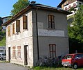
Former Sottocastello train station, sometimes also called Pieve di Cadore. The kilometer reading 4.573 can also be seen on the left above the station name.
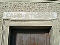
Sottocastello, capo stazione ("station master ")

Sottocastello, sala d'aspetto ("waiting room")
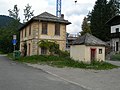
Tai di Cadore train station (km 5.738) with a separate toilet building in the foreground, the railway line ran to the left of the station building

Former Nebbiù train station (km 6,755).

Viaduct in Cortina in front of the train station.

Cortina d'Ampezzo train station (km 35.576).

Cimabanche train station (km 48.816) on the pass of the same name (Passo Cimabanche, Im Gemärk ).

Between Höhlenstein and Schluderbach: Crossing the Dürrensee on a bridge shared with the state road

Platform access to the former Toblacher See stop (km 61.903)

In winter, the northern part of the route (Cortina – Toblach) is used as a cross-country ski run, here near Toblach

Cross-country ski run near Toblach, view in the opposite direction
.JPG)
.jpg)
.jpg)
.JPG)
.JPG)


literature
- Evaldo Gaspari: La Ferrovia delle Dolomiti 1921–1964 . Athesia, Bozen, ISBN 88-7014-820-3 .
- Josef Dultinger : Forgotten Past . Narrow gauge railways of the Austro-Hungarian Army on the Dolomite Front 1915–1918. Publishing house Dr. Rudolf Erhard, Rum 1982.
- Walther Schaumann : The railways between Ortler and Piave in the war years 1915–1918 . Use and performance of the Austro-Hungarian and Imperial German railway formations. Bohmann Verlag, Vienna, Heidelberg 1971.
- Werner showerk, Walter Pramstaller, u. a .: Local and trams in old Tyrol . Self-published by Tiroler Museumsbahnen , Innsbruck 2008.
- Trade, industry, transport and agriculture. (...) Electric train Toblach – Schluderbach. In: Wiener Zeitung , February 8, 1905, p. 12 middle (online at ANNO ).
- Leonardo Malatesta: Un treno per Cortina . Pietro Macchione Editore, Varese, 2015, ISBN 978-8865702956 (with 350 previously unpublished photos)
- Albano Marcarini, Roberto Rovelli: Atlante italiano delle ferrovie in disuso . Istituto Geografico Militare, Florence 2018, ISBN 978-8852390968 .
Web links
- Tyrolean Museum Railways : The Dolomites Railway . Retrieved October 24, 2011 .
- Mauro Bottegal: Ferrovia delle Dolomiti. Retrieved October 24, 2011 (Italian, historical picture gallery and old timetables).
- Enrico Bassi: Belluno Ferroviaria. Retrieved October 24, 2011 (Italian, historical picture gallery and old postcard views).
- Umberto Brancaleoni: La ferrovia. Retrieved October 24, 2011 (Italian, old postcards from Tai di Cadore).
To today's cross-country trail:
- Cross-country skiing from the Gemärk to the Fames cross-country center near Cortina. Accessed on October 24, 2011 (information, map and picture gallery for the Toblach – Cortina trail).
Individual evidence
- ^ Alemagna road construction. Retrieved October 24, 2011 .
- ↑ Train connection Pustertal - Cadore: Delrio, Kompatscher and Zaia in Cortina. Retrieved February 15, 2016 .
- ↑ [1] with computer animation of the planned route

Adhesion membranes in operation: Bozen – Meran | Brennerbahn | Drautalbahn | Pustertalbahn | Renon Railway | Vinschgau Railway
Discontinued adhesion webs: Dolomitenbahn | Fiemme Valley Railway | Val Gardena Railway | Lana – Meran | Tramway Bolzano | Tram Merano | Tauferer Bahn | Überetscher Bahn
Cogwheel and funicular railways : Ferata Gran Risa | Gardena Ronda Express | Guntschnabahn | Lasa marble run | Mendelbahn | Raschötzer Bahn | Renon Railway | Schneebergbahn | Virglbahn
Coordinates: 46 ° 32 ′ 17 ″ N , 12 ° 8 ′ 26 ″ E