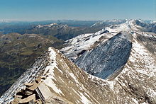
Main Alpine Ridge

Main Alpine Ridge describes an imaginary line along a summit ridge of the Alps , which runs from west to east and connects the central peaks of the Alps. Depending on the scientific approach, there are sometimes slight deviations from one another, especially in the east. Between the Ligurian Sea and the Vienna Basin , the main Alpine ridge is around 1,600 km long, making it one of the most important geomorphological structures in Central Europe .
Basics
Geologists assess the main Alpine ridge according to the rock and assume that in the Eastern Alps it is from the central Alps . They judge by the Alpid orogeny , the formation of the Alps, while hydrologists neglect the rock and focus on watersheds . Geographers separate Mediterranean and Central European cultural areas through the main Alpine ridge , while meteorologists neglect both the type of rock and watersheds and when defining the main Alpine ridge they orient themselves on the weather relevance, which is predominantly subject to northern or southern influence and is therefore mostly decided by the height of the mountain ranges.
The Eastern Alps drain largely to the Danube and the Black Sea on the north and south roofs , only the southern roofing of the Southern Limestone Alps to the Adriatic . The western Alps drain completely to the Mediterranean , here the main Alpine ridge forms the watershed between the western Mediterranean ( Rhone to the Gulf of Lion and the Ligurian Sea) and the eastern ( Po to the Adriatic Sea). Only in the Central Alps , the middle section, does it represent the main European watershed between the Mediterranean and the Atlantic (with the exception of Val Cadlimo south to the Rhine).
With the Engadin (across the Inn to the Danube), the main Alpine ridge shares the characteristic central southern fault with the whole of the Alps; in the western Alps, through large valleys, it changes several times from the French western roof to the flank of the Italian Piedmont ( Wallis / Rhône, Aostatal / Po, the Isèret valleys Tarentaise and Maurienne to the Rhône, the Dora valleys to the Po and Durancetal to the Rhône) and then runs eastward into the central watershed of the Apennines . In the Eastern Alps, it strictly follows the west-east grazing direction prevailing there, but runs for almost 200 kilometers only in mountainous areas with a low mountain range character .
course

Particularly in the central section of Switzerland and western Austria, the main Alpine ridge includes some of the most prominent mountains and passes in the Alps, especially the highest mountain in Europe, France and Italy, Mont Blanc and the highest mountain in Switzerland, the Dufourspitze .
Coming from Colle di Cadibona via Ligurian Alps and Sea Alps - following the French-Italian border via Cottian Alps and Graian Alps to Mont Blanc - Grosser St. Bernhard - Matterhorn - from Monte Rosa to Simplon Pass - on via Nufenen Pass to Gotthard - Rheinwaldhorn - Splügen Pass - Malojapass - Piz Bernina - Ofenpass - Reschenpass - following the Tyrolean-South Tyrolean border over the Ötztal Alps ( Weißkugel ) and the Timmelsjoch into the Stubai Alps - Brenner Pass - Zillertal Alps to the Dreiherrnspitze - into the Hohe Tauern (Salzburg-East Tyrolean and Carinthian border with deviations) - Niedere Tauern - Schoberpass - Eisenerzer Hauptkamm - Präbichl - Hochschwab - Seeberg - Hohe Veitsch - Niederalpl - Lahnsattel - Göller - Kalte Kuchl - Unterberg - Rechtsberg - Schöpfl - Hermannskogel - Kahlenberg .
The main Alpine ridge ends at Leopoldsberg , jumps over the Danube to Bisamberg at the Vienna Gate , and leads over the cliff zone (Waschberg zone ) to the Carpathians. This tour within the total Alpine mass is the motivation to look for the main Alpine ridge in the northern branch of the fanned out eastern edge of the Alps. The southern branch already separates at the Dreiherrnspitze, after about two thirds of the total stretch of the Alpine arc, and then forms the main watershed between the Mediterranean and the Black Sea.
See also
- Watersheds in the Alps - there with a more detailed description of the sections of the main Alpine ridge
Web links
Individual evidence
- ^ A b Ernst Heer, Jakob Maurer, Bernd Scholl, Rolf Signer (eds.): Aspects of spatial planning in Europe . Volume 42 of a series of publications on local, regional and state planning / Collection des documents pour l'aménagement national, régional et local. vdf Hochschulverlag, 1990, ISBN 978-3-7281-1744-1 (837-281-1744-7), reference length p. 182 ( limited preview in Google book search)
swell
- Meteorological main Alpine ridge in the encyclopedia of AlpenBergwetter.com