Dufourspitze
| Dufourspitze | ||
|---|---|---|
|
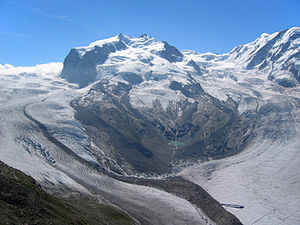
Monterosa with Gorner and Grenz glacier , Northrend and Dufourspitze |
||
| height | 4634 m above sea level M. | |
| location | Canton of Valais , Switzerland | |
| Mountains | Monte Rosa massif , Valais Alps | |
| Dominance | 78.2 km → Mont Blanc de Courmayeur | |
| Notch height | 2165 m ↓ Great St. Bernhard | |
| Coordinates | 633 205 / 87347 | |
|
|
||
| First ascent | 1855 by Charles Hudson , J. Smyth, C. Smyth, u. a. | |
| Normal way | demanding alpine tour (glaciated); Overall difficulty AD- (AD = assez difficile , quite difficult) | |
The Dufourspitze ( Italian Punta Dufour , French Pointe Dufour , Romansh Piz da Dufour ) in the Valais Alps is 4634 m above sea level. M. the highest peak in Switzerland and the entire German-speaking area . As the second highest peak in the Alps, it can be counted among the Seven Second Summits , depending on the definition of the European-Asian border .
location
The mountain top belongs to the Monte Rosa massif on the border with Italy . The mountain peak is around 160 m from the state border on Swiss territory. The entire mountain range is usually viewed as an Italian-Swiss border mountain, so that the role of the highest mountain, which lies entirely on Swiss territory, is the cathedral (also in the Valais Alps).
history
Originally this summit was called Gornerhorn (= strong or large mountain) in Switzerland and Cima Alta = high peak or high peak in Italy . Only the topography of the 19th century has shown that the Gornerhorn and Hochspitz were identical. In 1863 it was renamed by the Federal Council in honor of the Swiss general and cartographer Guillaume-Henri Dufour (1787–1875). Dufour was the editor of the first precise map work in Switzerland, named after him Dufour Map . The previous name Gornerhorn comes from the Walsers .
The first ascent took place on August 1, 1855 by a rope team led by Charles Hudson . Other participants in the rope team were John Birkbeck, Edward J. W. Stephenson and the brothers Christopher and James G. Smyth. The mountain guides Johannes and Matthäus Zumtaugwald from Zermatt and Ulrich Lauener from Lauterbrunnen paved the way for the English . Charles Hudson fell to his death ten years later on the first ascent of the Matterhorn during the descent.
Routes
The classic route over the eastern flank was first attempted in 1872 by the Englishmen Richard and William Pendlebury and Charles Taylor, the Swiss Ferdinand Imseng, the Austrian Gabriel Spechtenhauser and the Italian Giovanni Oberto.
The starting point for an ascent of the Dufourspitze from the Swiss side via the normal route is the Monte Rosa Hut ( 2883 m above sea level ).
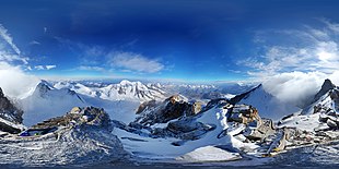
panorama
See also
literature
- Helmut Dumler, Willi P. Burkhardt: Four-thousanders in the Alps. 12th, updated edition. Bergverlag Rother, Munich 2001, ISBN 3-7633-7427-2 .
- Julius Kugy : In the divine smile of Monte Rosa . 2 volumes. Leykam-Verlag, Graz 1940.
Web links
- Virtual ascent of the Dufourspitze with 360 ° panoramas
- Dufourspitze at 4000m - the four-thousanders of the Alps
- Dufourspitze on GeoFinder.ch
- Dufourspitze on the ETHorama platform


