
Zermatt
| Zermatt | |
|---|---|
 |
|
| State : |
|
| Canton : |
|
| District : | Visp |
| BFS no. : | 6300 |
| Postal code : | 3920 |
| UN / LOCODE : | CH ZER |
| Coordinates : | 624 003 / 96943 |
| Height : |
1608 m above sea level M. |
| Height range : | 1468–4632 m above sea level M. |
| Area : | 242.91 km² |
| Residents: | 5765 (December 31, 2019) |
| Population density : | 24 inhabitants per km² |
|
Proportion of foreigners : (residents without Swiss citizenship ) |
41.1% (December 31, 2019) |
| Website: | gemeinde.zermatt.ch |
 Zermatt and the Matterhorn. |
|
| Location of the municipality | |
  |
|
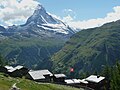
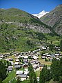
Zermatt ([ tsɛrˈmat ]) is a political municipality and a civic community with a civic council of the Visp district and a parish of the Visp deanery in the Swiss canton of Valais . In terms of population, Zermatt is the second largest town in the Visp district after Visp and is located in the Mattertal at an altitude of around 1610 m at the northeast foot of the Matterhorn . Zermatt is a mountaineering center and, thanks to the Matterhorn and its winter sports and hiking area, a well-known holiday resort in Switzerland.
The former name Praborgne ( French ), derived from the original Latin name Pratobornum , is no longer used.
geography

location
With an area of 243.4 km², Zermatt is one of the largest Swiss communities. The area comprises 1.3 km² building zone, 9.4 km² forest, 10.0 km² agricultural zone (including alpine pastures) and 183.0 km² nature protection zones. The highest point is at 4634 m above sea level. M. the Dufourspitze in the Monte Rosa massif. The lowest point at 1524 m above sea level. M. is located in the creek bed of the valley river on the border to the neighboring municipality of Täsch, near the corridor called the Schlangengrube . The wide high valley is bordered in the east by the mountain range Rimpfischhorn - Strahlhorn - Jägerhorn - Dufourspitze - Signalkuppe , in the south by the series Lyskamm - Castor and Pollux - Breithorn - Klein Matterhorn and west of the Theodulpass by Matterhorn - Dent d'Hérens - Tête Blanche . In the west, between the Zmuttbach valley and the Val d'Anniviers, lie the Dent Blanche , Ober Gabelhorn and Zinalrothorn mountain ranges .
The Zermatt municipality borders on Italy. The transition over the Theodulpass to Valtournenche is only passable for pedestrians and skiers due to the ice cover.
Waters
The main river in the valley is the Mattervispa , which flows through the center of Zermatt. It is created by the union of the Zmuttbach coming from the Zmutt Glacier , the Gornera coming from the Gorner Glacier , the Triftbach coming from the Trift Glacier and the Findelbach flowing from the Findel Glacier through the Findel Gorge . At Stalden , the Matter Vispa and the Saaservispa form the Vispa , which flows into the Rotten (Rhône) at Visp .
The Gornera takes up the Furggbach south of Furi , which rises on the Furgg Glacier under the east face of the Matterhorn and under the Upper Theodul Glacier. The creek Balmbrunnen flows from the Hohtängerrat over the Alp Breitboden into the Findelbach. From the Mettelhorn, the Luegelbach rushes down the steep run next to the Wisshorn to the Matter Vispa.
The Zmutt reservoir , which was built between 1961 and 1964 and serves as a water intake for the retention of the Grande Dixence system, is located on the Zmuttbach . The water is fed into the Dixence valley by pumping stations at Zmutt and Stafel.
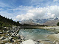
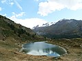
In addition to numerous nameless dead pits that have been created in recent years by the melting of the glaciers, the following Zermatt mountain lakes are worth mentioning:
- Grindjesee 2334 m above sea level M.
- Grünsee 2316 m above sea level M.
- Leisee 2232 m above sea level M.
- Mosjesee 2140 m above sea level M.
- Riffelsee 2757 m above sea level M.
- Schwarzsee 2552 m above sea level M.
- Stellisee 2537 m above sea level M.

Grindjesee.
Grünsee.
Quiet lake.

Mosjesee.

Riffelsee.

Schwarzsee.

Stellisee.

.jpg)


mountains
22 main Swiss peaks over 4000 meters are wholly or partially in the Zermatt area:
- Dufourspitze ( Monte Rosa ), 4634 m above sea level M. , the highest mountain in Switzerland.
- Nordend (Monte Rosa), 4609 m above sea level M.
- Zumsteinspitze (Monte Rosa), 4563 m above sea level. M.
- Signalkuppe (Monte Rosa), 4554 m above sea level M.
- Liskamm (sometimes Lyskamm), east summit, 4527 m above sea level. M.
- Liskamm (Lyskamm), west summit, 4479 m above sea level. M.
- Matterhorn , 4478 m above sea level M.
- Parrotspitze (Monte Rosa), 4432 m above sea level M.
- Dent Blanche , 4356 m above sea level M.
- Ludwigshöhe (Monte Rosa), 4341 m above sea level M.
- Castor (twins), 4228 m above sea level M.
- Zinalrothorn ( Weisshorn group ), 4221 m above sea level M.
- Rimpfischhorn ( Mischabel ), 4199 m above sea level M.
- Strahlhorn (Mischabel), 4190 m above sea level M.
- Dent d'Hérens , 4171 m above sea level M.
- Breithorn west summit, 4164 m above sea level M.
- Breithorn middle summit, 4159 m above sea level M.
- Western Breithornzwilling, 4139 m above sea level M.
- Gendarme (eastern Breithorn twin), 4106 m above sea level M.
- Pollux (twins), 4092 m above sea level M.
- Schwarzfluh (Breithorn), 4075 m above sea level M.
- Ober Gabelhorn (Weisshorn Group), 4063 m above sea level M.
Other prominent mountains in the municipality are the Oberrothorn ( 3414 m above sea level ), the Stockhorn ( 3532 m above sea level ), the Äbihorn ( 3473 m above sea level ), the Unter Gabelhorn ( 3392 m above sea level ). , the Theodulhorn ( 3468 m above sea level ), the Riffelhorn ( 2928 m above sea level ) and the Mettelhorn ( 3406 m above sea level ).

Panorama of the main Alpine ridge south of Zermatt. The main peaks and ridges that are visible are (from left to right): Weissgrat, Nordend and Dufourspitze ( Monte Rosa Massif ), Liskamm , Castor , Pollux , Breithorn , Klein Matterhorn , Matterhorn . The glaciers shown are (from left to right): Gorner Glacier (also in the lower part of the picture), Monte Rosa Glacier, Grenz glacier , Black Glacier , Breithorn Glacier , Triftji Glacier , Lower Theodul Glacier , Upper Theodul Glacier

glacier
In the high valleys of Zermatt there are many glaciers , some of which are still quite large despite the ongoing decline . Together with all of the side glaciers, the glacier system of the Gorner glacier covers an area of 68 km², which is the second largest contiguous glacier area in the Alps after the Aletsch glacier.
List of Zermatt glaciers:
- Findel Glacier
- Triftji Glacier
- Gorner glacier
- Eagle glacier
- Monte Rosa Glacier
- Border glacier
- Twin glaciers
- Black Glacier
- Breithorn glacier
- Theodul Glacier with Plateau Rosa
- Furgg Glacier
- Tiefmatten Glacier
- Zmutt glacier
- Matterhorn glacier
- Stockji glacier
- Schönbiel Glacier
- Hohwäng Glacier
- Arben Glacier
- Gabelhorn Glacier
- Trift glacier
- Rothorn Glacier
- Boden glacier
climate
Due to the high mountains, which shield the precipitation in the main weather directions, as well as the generally high terrain level, the climate is mild and low in precipitation for the altitude and the geographical latitude. The tree line is at a height of 2,200 to 2,300 m and thus in the central and southern European peak area. The average rainfall in the village is around 700 mm per year. The surrounding mountains, especially along the Italian border, are - relative to the altitude - significantly colder and more rainy. On the signal peak of Monte Rosa , the average annual precipitation is 4100 mm.
| Zermatt | ||||||||||||||||||||||||||||||||||||||||||||||||
|---|---|---|---|---|---|---|---|---|---|---|---|---|---|---|---|---|---|---|---|---|---|---|---|---|---|---|---|---|---|---|---|---|---|---|---|---|---|---|---|---|---|---|---|---|---|---|---|---|
| Climate diagram | ||||||||||||||||||||||||||||||||||||||||||||||||
| ||||||||||||||||||||||||||||||||||||||||||||||||
|
Average monthly temperatures and precipitation for Zermatt
Source: www.meteoschweiz.admin.ch
|
|||||||||||||||||||||||||||||||||||||||||||||||||||||||||||||||||||||||||||||||||||||||||||||||||||||||||||||||||||||||||||||||||||||||||||||||||||||||||||||||||||||
Settlements
In the Zermatt area are the hamlets Findeln , Tuftern , Winkelmatten , Blatten , Zum See and Zmutt , mostly with their own chapels. They used to be used as summer settlements. Today they are popular tourist destinations.

Findeln , above Zermatt.

The hamlet of Zmutt .
Tufting at Sunnegga .
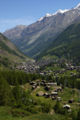
View of Zermatt, in the foreground Blatten.

The hamlet of the lake .

The hamlet of Zum See in 1923.
Winkelmatten, which has grown together with Zermatt .

Matterhorn near Herbrigg on the way to Hubel, Zmutt .


language
Even before Salurn in South Tyrol, Zermatt is the southernmost place of the closed German-speaking area (as a German-speaking island, only the Lystaler places Gressoney and Issime are another 20 km to 30 km south).
history


Like many high alpine valleys, the Mattertal has been inhabited for over 6000 years.
During the so-called optimum of the Roman era , the climate was warmer than in the subsequent Little Ice Age until the middle of the 19th century and also today. At that time, walking on glaciated pass crossings in Valais such as the Theodul Pass from the south into Mattertal was relatively easy, at least in summer - especially since narrow gorges and rocky areas on the slopes did not make this difficult or impossible, as elsewhere. Accordingly, the first settlement in the upper Mattertal was likely to have taken place from the north, before the German-speaking population immigrated, which explains the earliest Romanic names of Zermatt or Aroleit for the plateau south of it towards Theodul Pass.
Zermatt is mentioned for the first time as Pratobornum in 1280 , which can be translated as “Matte in the headwaters” (from Middle High German mat / mate “Wiese”; see also Alm (mountain pasture) ) or “Matte in the border marks”. Zermatt is a daughter parish of St. Niklaus . The parish of Zermatt is mentioned in a document dated April 25, 1285. A village chapel was built around 1290. Between the 15th and 17th centuries, the Zermatters bought themselves free from various feudal lords.
In the Middle Ages, important trade routes led via Zermatt over the Theodul Pass to Italy. Coin finds show that this path was used as early as the Roman times in the 1st to 4th centuries AD. The coins can be viewed today in the Zermatlantis Matterhorn Museum . When the glaciers had retreated a long way during the warm phase around 1000 to 1300, the Theodul Pass was also free of ice on the north side. The partially paved mule paths date from the 13th century , the remains of which can still be seen today.
The first natural scientists came to Zermatt around 1780. A modest foreign visit began after 1820, and from 1838 there was a guest hostel. Between 1850 and 1860, a road between Zermatt and St. Niklaus , which can be driven on by carriages , was built. The first small hotel was opened in 1852. The Goms farmer's son Alexander Seiler I opened the Hotel Monte Rosa in 1855 and founded his hotel empire. A hotel on the Riffelberg was built in 1854. In 1858 a mountain guide company was founded in Zermatt, which was dissolved again in 1860. In 1873 the Zermatt St. Niklaus guide company was founded . Another tourism pioneer was Joseph Anton Clemenz , who opened Mont Cervin in 1852 and sold it to Seiler 15 years later.
In 1865 the Englishman Edward Whymper made the first ascent of the Matterhorn. This was the starting shot for the ascent to the world-famous tourist destination.
In 1891, the Visp-Zermatt railway line from Visp to Zermatt was opened for summer operations. In 1898 the railway followed on the Gornergrat .
In January 1902, as President of the Monte Rosa section of the Swiss Alpine Club , Hermann Seiler organized the first ski course in Switzerland in and near Zermatt.
From Zermatt in September 1903, aeronauts Eduard Spelterini and Hermann Seiler, together with a third person, managed to fly over the high Alps for the first time in a balloon.
On December 31, 1927, Hermann Seiler had 180 invited English summer regulars picked up in St. Niklaus with 50 sledges and taken to Zermatt. With the completion of the protective structures at the end of October 1933, today's Matterhorn-Gotthard-Bahn was able to start operating all year round to Zermatt, as it had been to St. Niklaus since 1928, a requirement for regular winter seasons in Zermatt. As early as 1944, more guests visited Zermatt in winter than in summer for the first time.
In March 1963, a typhus epidemic raged in Zermatt with over 400 sick people and three dead.
Air Zermatt , founded in 1968, set up a heliport at the entrance to the village .
Thanks to tourism, Zermatt has grown significantly over the years. The typical image of a Valais mountain village can only be found in the center and in the outlying hamlets, while extensive holiday settlements have emerged in the valley.
Zermatt is a car-free municipality, the road from Täsch can only be used with the appropriate permit. In Zermatt, transport tasks are carried out by specially approved commercial electric vehicles or horse taxis. 124 hotels and numerous guest beds in holiday apartments offer space for over 17,500 guests.
81.3% of the population belong to the Roman Catholic Church , 9.2% to the Evangelical Reformed Church , 5.4% belong to another denomination and 4.1% are non-denominational.
coat of arms
The coat of arms of the municipality of Zermatt shows a yellow lion on a red background, standing on two of three green hills. Two five-pointed stars flank the heraldic animal. The symbolic power of the lion has always been reflected in a wide variety of coats of arms. It is believed that the Zermatt lion was “borrowed” from the coat of arms of the Vespia Nobilis (district capital Visp ) as a sign of district affiliation .
population
| year | 1802 | 1850 | 1900 | 1950 | 2000 | 2010 | 2012 | 2014 | 2016 |
|---|---|---|---|---|---|---|---|---|---|
| Residents | 436 | 369 | 741 | 1395 | 5988 | 5720 | 5786 | 5770 | 5714 |
tourism
Winter sports areas


The winter sports area around Zermatt is divided into the three areas Matterhorn glacier paradise / Schwarzsee paradise , “ Gornergrat ” and Sunegga paradise / Rothorn paradise . Since the construction of the new Furi - Riffelberg cable car in summer 2006, the three ski areas ( Matterhorn ski paradise ) have been linked. With the annexed area of Breuil-Cervinia ( Italy ), winter sports enthusiasts have 63 mountain railways and 257 kilometers of slopes at their disposal. The longest descent from the Kleiner Matterhorn to Zermatt is approx. 15 km long and has an altitude difference of 2,279 m.
The cable car ride from the middle station on the Trockenen Steg to the Matterhorn glacier paradise (Klein Matterhorn) leads to an altitude of 3820 m above sea level. M. The highest mountain station was only built at the end of the 1970s, after the mountain railway company had already received the concession at the end of the 1960s. An elevator leads from the mountain station to the summit of the Kleiner Matterhorn. A short time later, the project would hardly have been feasible, which the municipality of Saas-Fee had to find out with its project on the Feechopf ( 3888 m above sea level ).
A lift takes you to the summit of the Klein Matterhorn (highest vantage point in Europe) at 3883 m above sea level. M. The panorama stretches from the Swiss Alps on the French Alps to the Italian Po Valley . The Matterhorn glacier paradise area is the core of the Zermatt summer ski area.
The Gornergrat area is made accessible by the Gornergratbahn , one of the oldest electric mountain cogwheel routes in Switzerland. About halfway there is the starting point of the Riffelalptram at the Riffelalp station , the highest tram in Europe (only operated in summer) from the train station to the five-star hotel Riffelalp Resort 2222 m . At the end of the lift on the Gornergrat there is a hotel, an observatory and a lookout point with a panoramic view of the Gorner glacier and the Monte Rosa massif.
Summer ski area

The summer ski area of Zermatt is the largest and highest in Europe. Depending on the snow conditions, up to 20 km of slopes are available. The longest run has a length of 7 km. The summer ski area stretches from the Trockener Steg over the Theodul Glacier to the Testa Grigia above the Theodul Pass , further over the Plateau Rosa to the Klein Matterhorn . The Gobba di Rollin , which is a few hundred meters south of the Little Matterhorn, close to the border with Italy, is 3899 m above sea level. M. the highest point of a European ski area. It can only be reached by ski lifts in summer. The glacier lift to the Furggsattel is also open in spring and autumn . The summer ski area is used by many national ski teams for summer training. For several years now, a combined ticket for summer ski vacationers has been offered together with Saas-Fee . The travel time from Täsch to Saas-Fee is around 40 minutes.
Along with the Hintertux Glacier, Zermatt is the only ski area in the Alps that is open 365 days a year.
Cross-country skiing
Zermatt itself has no cross-country trails. The 15 km long, competition-proven track lies below Zermatt between Täsch and Randa . Between 1981 and 1989 the Zermatt night cross-country race , a 10 km cross-country skiing race , was held eight times in the streets of Zermatt.
Rockclimbing
The tourist discovery of the Mattertal began in 1792 with the first ascent of the Klein Matterhorn and the Theodulhorn by the Geneva scholar Horace-Bénédict de Saussure . No fewer than 58 first ascents and 47 first traverses followed in the years 1855 to 1894. In 1855, for example, the first ascent of the Dufourspitze of Monte Rosa took place . In 1858 a mountain guide company was founded in Zermatt, which was dissolved again in 1860. In 1873 the Zermatt St. Niklaus guide company was founded . The first ascent of the Matterhorn took place in 1865 . In 1931 the north face of the Matterhorn was successfully climbed for the first time.
The Haute Route is an international, high-alpine hiking and ski crossing over 180 kilometers from the Mont-Blanc massif near Chamonix , France , through the Valais Alps to Zermatt. It leads over various glaciers and high mountain crossings and in stages to mountain huts such as the Bertolhütte and the Schönbielhütte .
hike
Zermatt offers a network of hiking trails of more than 400 km in all valley areas. From Saas-Fee via Grächen ( Balfrin High Trail ) and via Gasenried to Zermatt ( Europaweg ), the regional hiking route 27 “Swiss Tour Monte Rosa” leads from Wanderland Schweiz . The whole hike takes three days, but can also be done in individual stages. The tour is only recommended for experienced and persevering hikers.
Mountain run
Between 1982 and 2012, the Matterhorn Run took place from the Zermatt train station ( 1605 m above sea level ) to the destination Schwarzsee ( 2580 m above sea level ) with a distance of 14.34 km. The Zermatt Marathon (which leads from St. Niklaus via Zermatt to the Riffelberg) has been taking place in July since 2002 and the Matterhorn Ultraks in August since 2013.
Mountain skiing
The Patrouille des Glaciers PDG has been running from Zermatt to Verbier since 1943 . A patrol started in 2010 with Zermatt ski mountaineer Martin Anthamatten holds the course record.
traffic

Matterhorn Gotthard Railway (MGB)
The most important feeder into Zermatt, which has been freed from cars with combustion engines, is the Matterhorn-Gotthard-Bahn (MGB). It was created in 2003 through the merger of the Furka-Oberalp-Bahn and the Brig-Visp-Zermatt-Bahn . The 35 km long railway line from Visp to Zermatt was opened in 1891. The Brig – Visp section was not built until 1930. The Glacier Express also runs on your route to Visp , Brig-Glis , Andermatt and Disentis . Since the opening in 2007 of the Lötschberg base tunnel, the NEAT is the Zermatt train station of Zurich made with change to the narrow-gauge railway in the station Visp reached in three hours.
Gornergratbahn
.jpg)
The cogwheel route of the Gornergratbahn (GGB), which leads to the Gornergrat , begins right next to the MGB train station . In 1896 the construction of the imposing excursion train started. Since the end station Gornergrat at an altitude of 3089 m above sea level. M. is located, the construction time between the snowmelt and the onset of winter was extremely short. Over 1000 workers were deployed - most of them were Italians, as was the case with all the major railway constructions in Switzerland at the time. A total of around 2,400 workers were employed during the two-year construction period.
Train stations
Sunnegga , Blauherd , Grünsee , Rothorn , Findeln , Gant , Gornergrat , Riffelalp / Riffelberg / Rotenboden , Hohtälli , Stockhorn , Rote Nase , Furi , Trockener Steg , Klein Matterhorn , Gobba di Rollin , Plateau Rosa , Theodulpass / Testa Grigia, Gandegg , Schwarzsee , Furggsattel .
Chronicle of the mountain railways in Zermatt


- 1898: Opening of the Gornergratbahn (summer operation only)
- 1928: The Gornergratbahn also runs in winter for the first time
- 1942: Construction of the first ski lift from Zermatt to Sunnegga
- 1947: Construction of the Zermatt – Sunnegga chairlift
- 1955: Foundation of the LZS (aerial cableway Zermatt– Schwarzsee )
- 1955/56: Construction of the Zermatt – Furi –Schwarzsee cable car
- 1958–1958: Construction of the Gornergrat - Hohtälli - Stockhorn cable car
- 1962: Construction of the Furgg – Schwarzsee aerial cableway
- 1963: Construction of the Hörnli ski lift
- 1963–1965: Construction of the Zermatt – Furi – Furgg– Trockener Steg cable car
- 1964: Foundation of the Rothornbahn AG
- 1967: Construction of the Sunnegga– Blauherd gondola and the Blauherd– Rothorn aerial cableway
- 1971: Construction of the Gant –Blauherd cable car
- 1973: December 17th. Definitive approval for the cable car to the Kleine Matterhorn
- 1979: Opening of the cable car to the Kleine Matterhorn
- 1980: Opening of Switzerland's first underground funicular railway, Zermatt – Sunnegga ( Sunneggatunnel )
- 1982: Construction of the Zermatt – Furi six-seater gondola and the Furi – Trockener Steg aerial cableway
- 1984: As a result of a major fire at the mountain station, new construction of the Triftji ski lift to Rote Nase
- 1986: Opening of the Hohtälli - Rote Nase aerial cableway
- 1989: Replacement of the Sunnegga – Blauherd and Patrullarve – Blauherd ski lifts with a quad chairlift
- 1990: Construction of the Furgg – Sandiger Boden – Theodul glacier chairlift
- 1991: Opening of the Furgg – Schwarzsee group gondola to replace the old cable car
- 1996: Opening of the new Blauherd – Rothorn aerial tramway to replace the old aerial cableway
- 1998: Opening of the Gant – Hohtälli cable car
- 2002: Merger of Sunnegga-Express AG, Rothornbahn AG and Matterhornbahnen AG to form Bergbahn Zermatt AG, the largest mountain railway company in Switzerland
- 2002: Opening of the eighth Matterhorn Express Zermatt – Furi – Schwarzsee gondola lift
- 2002: Opening of the Gifthittli chairlift
- 2003: Opening of the new Furggsattel chairlift . The Furggsattel Gletscherbahn is the first chairlift to be built on a Swiss glacier. It is the longest glacier chairlift in Europe. The mountain station was on Italian soil when it was built; Since the highest line of the ridge is defined as the limit, the ridge-forming glacier has now melted away and the rock edge now forms the highest line, the mountain station (and thus the entire railway) is now in Switzerland.
- 2005: Opening of the combined lift (gondola and chairlift) between Sunnegga and Blauherd
- 2006: Opening of the Riffelberg Express cable car between Furi and Riffelberg
- 2007: Opening of the Sunnegga - Findeln - Breitboden chairlift
- 2008: Dismantling of the Gornergrat – Hohtälli – Stockhorn cable car. A connecting piste from Hohtälli to Gifthittli was built in its place. A new ski lift was built to re-develop the Stockhorn.
- 2008: Construction of a fully automatic crossliner from Sunnegga to the beginners' park at Leisee
- 2009: Construction of the extension of the Matterhorn Express from Schwarzsee via Furg to Trockener Steg. This lift replaces the old gondola lift from 1965 from Furgg to Trockener Steg as well as the group gondola lift Furgg – Schwarzsee. With the new train, the Trockener Steg can be reached in 25 minutes without having to change trains.
- 2010: Dismantling of the upper section of the Theodul Express (sandy soil - Theodul glacier). The extension of the Matterhorn Express, which was implemented in 2009, serves as a replacement.
- 2013: Renewal of the Zermatt-Sunnegga funicular.
- 2015: 6-seater chairlift Joscht - Hirli to replace the Hörnli ski lift
- 2016: 6-seater chairlift Gant - Blauherd to replace the 4-seater gondola lift
- 2016: Start of construction of the Klein Matterhorn 3S cable car as a supplement to the aerial tramway
- 2018: Opening of the 3S-Bahn Klein Matterhorn. It connects the Trockener Steg station at an altitude of 2,939 meters with the Matterhorn glacier paradise at an altitude of 3,821 meters.
- 2020: Construction and commissioning of the automatic 10-seater gondola Kumme. It connects Tufternkehr via the Wyss Gufer middle station with the Rothorn.
Car-free Zermatt

The streets of Zermatt have been closed to private car traffic since 1931. The existing driving ban was confirmed by the voters in Zermatt in 1972 and 1986. The 5 km long road between Täsch and Zermatt may only be used with a special permit, which is given to locals, guests with a second home, taxis, supply and rescue vehicles. The traffic capacity of the road has meanwhile been exceeded. On March 6, 2005, the voters of Zermatt approved an expansion of the road connection. Since then, the municipality of Zermatt and the canton of Valais have been examining the renovation and expansion of the road. This expansion has been a long time coming. For the duration of their stay, holiday guests have to park their car in the large multi-storey car park in Täsch, which has over 2000 parking spaces that are subject to a charge. In addition, around 900 parking spaces are offered by private companies that offer a 24-hour taxi service to Zermatt. A transfer platform to the Matterhorn Gotthard Railway is integrated in the Matterhorn Terminal . Shuttle trains with low-floor wagons, which can also be used with baggage carts, run to Zermatt every 20 minutes. On the nights between Friday and Sunday, the trains run every hour.

Electric buses have been in operation in Zermatt since January 1988 to transport skiers . These serve all valley stations of the Zermatt mountain railways on a circular route of around 4.5 km in length. In December 1991, a small electric bus was also put into operation for the development of the Winkelmatten suburb. The number of passengers at peak times in winter is high. Depending on the type of bus, there is space for 27, 50 or 80 passengers. The bus services are included in the ski pass. In normal road conditions, one battery charge is enough to cover a daily workload of a maximum of 22 courses. As for all vehicles in Zermatt, the maximum speed is 20 km / h.
While private vehicles with internal combustion engines are prohibited in Zermatt, electric cars are permitted for commercial use, but are only allowed to travel at a maximum speed of 20 km / h. With the exception of the electric buses, many of these small and narrow electric cars are on the road, as transport vehicles for craftsmen, as delivery vehicles for supermarkets, shops, restaurants and hotels, as well as taxis or hotel pick-ups to pick up guests and their luggage from the train station. Since a good 57 percent of electricity in Switzerland is produced with hydropower, these electric cars are not only completely emission-free on site, but are also generally considered to be environmentally friendly. Depending on the usage profile, the operators have two or three simple lead-acid batteries for each vehicle that can be changed . Since 1947, the number of approved electric vehicles has grown to around 500. In connection with the existing road system, the use of vehicles is now leading to traffic problems, which are to be countered by means of traffic calming measures. There are also carriage companies.
air traffic
Zermatt is the headquarters of Air Zermatt AG, a Swiss helicopter company founded in 1968.
politics
Community Policy:
In Zermatt, the seven-member municipal council, the executive, is elected every four years. The next elections will take place in autumn 2024. Romy Biner Hauser (CVP) has been the mayor since January 2017.
The municipal council election on October 18, 2020 resulted in the following distribution of seats for the legislative period 2021–2024:
Economic policy:
The extensive cultural landscape, developed over centuries, includes several alpine areas . In order to harmonize traditional agriculture with general spatial development, the communities of the Mattertal carried out study projects.
Town twinning
-
 Alfano , Italy
 -
 Lijiang , China
 -
 Myōkō , Japan
 -
Sexten , South Tyrol, Italy
-
 Snowbird (Utah) , United States
 -
 Castro Daire , Portugal
Tourist Attractions


- In 2006 a striking glass dome was erected on the church square. Below is the Matterhorn Museum with a reconstructed village and an archaeological excavation site.
- Marmot fountain : The marmot fountain, built in 1906 in the center of the village, is a Zermatt landmark.
Churches and chapels
The majority of the residents of Zermatt are of the Roman Catholic denomination. With the decentralized settlement structure, in addition to the parish church, several chapels were built in the municipality over time:
- 1575: old parish church with chaplain house (Saint Mauritius); 1910–1913 new construction of the parish church
- 1607: Winkelmatten Chapel (Holy Family)
- 1640: Blatten Chapel (Mary, Queen of the Rosary)
- 1691: Findeln Chapel (Saint James)
- 1693: Chapel Ried / Howeten (Saint Luzia)
- 1747: Furri House of Prayer ( Our Lady of Sorrows)
- 1784: Schwarzsee Chapel (Maria zum Schnee)
- 1797: Zmutt Chapel (Saint Catherine)
- 1870: English Church (St. Peter) mainly for tourists
- 1880: Riffelalp Chapel (the Sacred Heart of Jesus)
- 1902: Trift prayer house (Holy Mother of God)
- 1950: Gornergrat Chapel (Saint Bernard of Aosta)
- 1950: Creation of the Schibuwaldje Way of the Cross
- 1961: Riffelberg Chapel (Holy Brother Klaus)
- 1964: Chapel Zum See (Saint Barbara)
Special features of the mountain railways
- Special crossing mast for the 130 kV overhead line crossing of the Zermatt-Furi aerial cableway
- Highest cable car pillar in Switzerland ( Gant – Hohtälli cable car , height: 94 meters)
- The T-bar lift Gandegg is with a length of 2,899 meters, the longest ski tow in the world.
Mountain huts and shelters
The SAC and other sponsorships run various mountain huts and accommodations on the heights around Zermatt.

- Gandegghütte , 3030 m
- Rothornhütte , 3198 m
- Hörnli (Zermatt) , 3279 m
- Hörnlihütte , 3260 m
- Arbenbiwack, 3225 m
- Monte Rosa Hut , 2883 m
- Schönbielhütte , 2694 m
- Solvay hut , 4003 m
- Berggasthaus Trift, 2337 m
- Berghaus Fluhalp
- Pension Edelweiss, Alterhaupt
Largest snow igloo in the world

The world's largest snow igloo was built in Zermatt in winter 2016 as part of the Zermatt igloo village. In around 2000 hours, a 14-person team built the igloo on the Gornergrat at the Rotenboden station above Zermatt with 1400 blocks of snow and thus secured entry in the Guinness Book of Records on January 20, 2016. The igloo, which was built for the 20th anniversary of the igloo villages in Switzerland, had a diameter of 12.9 meters and an interior height of 9.92 meters. In addition to sleeping igloos, the complex also had a bar, a restaurant and a wellness area.
Regular events
- Zermatt Festival : The Zermatt Festival has been taking place since September 2005 . This event takes up the tradition of the Zermatt summer concerts and master classes from the 1950s and 1960s. One of the event locations is the Riffelalp Chapel at 2222 m above sea level. M. , the Berlin Philharmonic will perform, among others .
- Zermatt Unplugged : The Zermatt Unplugged music festival is another highlight, the artists only use acoustic instruments . Zermatt Unplugged took place for the first time in 2007 and is the only festival of its kind in Europe.
Personalities

- Martin Anthamatten (* 1984), ski mountaineer
- Alfred Aufdenblatten (1897–1975), cross-country skier
- Fränzi Aufdenblatten (* 1981), ski racer
- Karl Burgener (1918–1994), important sponsor of the 20th century of church chant in Upper Valais
- Joseph Anton Clemenz (1810–1872), hotelier and pioneer of tourism in Zermatt
- European curling champions 1983: Amedée Biner , Walter Bielser , Alex Aufdenblatten , Alfred Paci , Zermatt Curling Club
- Otto Furrer (1903–1951), co-founder of the winter sports resort of Zermatt and successful winter sports enthusiast in the 1920s and 1930s
- Ulrich Inderbinen (1900–2004), mountain guide. Climbed the Matterhorn a total of 371 times and at the age of 90 for the last time
- Bruno Jelk (* 1943 in Plaffeien ), head of mountain rescue from 1980 to 2014, developed, among other things, the tripod for rescuing from crevasses
- Alphonse Julen (1899–1988), cross-country skier
- Heinz Julen (* 1964), artist
- Mario Julen (* 1963), mountain guide who was the first European to complete the Everest traverse.
- Max Julen (* 1961), Olympic champion giant slalom
- Daniel Lauber (* 1937), former member of the Council of States (1983–1991) and former mayor (1976–1990)
- Josef Marie Lochmatter (1833–1882), mountain guide and pioneer of tourism in Zermatt
- Bernhard Perren (1928–1960), ski racer and mountain guide
- Diego Perren (* 1965), Olympic curling champion in Nagano 1998
- Gottlieb Perren (1926–2014), skier and mountain guide
- Alexander Seiler (1819–1891), hotel pioneer and pioneer of tourism in Zermatt
- Hannes Taugwalder (1910–2007), writer, local politician and entrepreneur
- Peter Taugwalder (1820–1888), first to climb the Matterhorn
- Father Henry Volken SJ (1925–2000), President of the United Nations Development Aid Committee
- Johannes Zumtaugwald (1826–1900), first to climb the Dufourspitze
- Elia Zurbriggen (* 1990), ski racer
- Laura Zurbriggen (* 1995), presenter and model
literature
- Henri Rougier: Zermatt and its mountains. Change in a high alpine cultural landscape . Orell Füssli, Zurich 2003, ISBN 3-280-05053-7 .
- Beat P. Truffer: New and old from Zermatt. The fascinating history of the world spa from the beginning until today . Aroleit-Verlag, Zermatt 2008, ISBN 978-3-905097-20-7 .
- Bernard Truffer: Zermatt. In: Historical Lexicon of Switzerland . 2014 .
Web links
- Zermatt on the ETHorama platform
- Official website of the Zermatt community
- Official website of Zermatt Tourism
- Official website of Zermatt Bergbahnen AG
- Official website of the Zermatt civic community
- Official WebGIS of the municipality of Zermatt
Individual evidence
- ↑ FSO Generalized Boundaries 2020 . For later parish mergers, heights are summarized based on January 1, 2020. Accessed May 17, 2021
- ↑ Generalized limits 2020 . In the case of later community mergers, areas will be combined based on January 1, 2020. Accessed May 17, 2021
- ↑ Regional portraits 2021: key figures for all municipalities . In the case of later municipal mergers, population figures are summarized based on 2019 Accessed May 17, 2021
- ↑ Regional portraits 2021: key figures for all municipalities . In the case of later municipal mergers, the percentage of foreigners summarized based on the 2019 status. Accessed May 17, 2021
- ^ Bernard Truffer: Zermatt. In: Historical Lexicon of Switzerland .
- ↑ Wisshorn on ETHorama
- ↑ a b Brief portrait of the Zermatt community
- ↑ A. Julen: The names of Zermatt and its mountains in the light of history. In: Blätter für die Walliser Geschichte 11, 1951, pp. 3–58.
- ↑ Breithorn (Zermatt) on ETHorama
- ↑ Theodulhorn on ETHorama
- ↑ Riffelhorn on ETHorama
- ↑ a b Zermatt information brochure , PDF
- ^ Alfred Lüthi: Zermatt and the high alpine passes. A field archaeological investigation. o. O. 1978.
- ↑ Christian Imboden, Berge: Beruf, Berufung, Schicksal , Rotten Verlag, Visp, 2013, p. 37 and Stanislaus Kronig, Family Statistics and History of Zermatt , 1927, p. 286.
- ↑ Hotel Monte Rosa on ETHorama
- ↑ Fred. Ammann: Swiss host families. Short genealogical-biographical chronicles of traditional restaurant and hotelier families. Seiler family Zermatt. Follow-up issue 14. Biel 1980; Mark Andreas Seiler: One glacier - one hotel - one family. Horizons of a Valais hotelier dynasty, Rotten Verlag, Visp 2012, ISBN 978-3-905756-67-8 , p. 196 ff. (With numerous references.)
- ↑ a b Christian Imboden, Berge: Beruf, Berufung, Schicksal , Rotten Verlag, Visp, 2013, p. 64.
- ↑ Alpina of February 1, 1902, No. 2, p. 35; Neue Zürcher Zeitung of February 8, 1952, No. 282 (6), sheet 5.
- ↑ Neue Zürcher Zeitung of September 22, 1903, No. 263, p. 2; Landscape shots of this balloon ride in: Eduard Spelterini. Photographs of the balloon pioneer, ed. by Thomas Kramer and Hilar Stadler, Zurich 2007, pp. 46 and 50.
- ↑ Zermatt Tourismus: Data on Zermatt's history
- ↑ Marc Tribelhorn: Deadly bacteria on the Matterhorn In: Neue Zürcher Zeitung . March 11, 2019.
- ^ Report of an ETH seminar on the Zermatt settlement.
- ^ Zermatt Tourism: Zermatt Infrastructure
- ↑ Revealed: the ski resorts that exaggerate piste lengths (English), on telegraph.co.uk
- ↑ Cross-country skiing in Zermatt
- ↑ Christian Imboden, Berge: Beruf, Berufung, Schicksal , Rotten Verlag, Visp, 2013, p. 50.
- ↑ Official site for the Patrouille des Glaciers
- ↑ 10 years of Zermatt Bergbahnen AG , inside .zermatt
- ↑ Reopening of the Sunnegga funicular , inside.zermatt
- ↑ Arrival by private car
- ↑ Matterhorn Terminal
- ↑ E-bus operation in the municipality of Zermatt
- ↑ Hydropower Switzerland , Swiss Federal Office of Energy SFOE
- ↑ Zermatt inside, April 2012, Volume 10, No. 2 (PDF; 102 kB)
- ↑ Urban traffic ( memento from December 19, 2009 in the Internet Archive )
- ↑ News archive: Results of municipal council elections on October 18, 2020. In: Zermatt municipality. Retrieved February 14, 2021 .
- ↑ Project: Model project for sustainable spatial development 2014–2018: Appreciation of natural and cultural landscapes through new products and services in the sustainable geotourism region of Mattertal. Grächen 2014.
- ↑ Zermatlantis, the Matterhorn Museum, opens its doors in December 2006
- ↑ Parish Church of Saint Mauritius
- ↑ Winkelmatten Chapel on ETHorama
- ↑ 140 years of the English Church in Zermatt. (No longer available online.) Zermatt.ch, archived from the original on June 23, 2010 ; Retrieved July 10, 2010 .
- ↑ Hörnli on ETHorama
- ↑ Hörnlihütte on ETHorama
- ↑ The largest igloo is under the Gornergrat. nzz.ch
- ↑ Record in the snow: The largest igloo in the world. guinnessworldrecords.de
- ↑ Zermatt Festival ( Memento of the original from July 14, 2005 in the Internet Archive ) Info: The archive link has been inserted automatically and has not yet been checked. Please check the original and archive link according to the instructions and then remove this notice.
- ↑ Bruno Jelk, rescue chief in Zermatt, interview in the Rhone newspaper, 2006.
- ↑ Himalaya Expedition 2006 ( Memento from March 15, 2009 in the Internet Archive )
Baltschieder | Eisten | Embd | Grächen | Lalden | Randa | Saas-Almagell | Saas-Balen | Saas-Fee | Saas-Grund | St. Niklaus | Stalden | Staldenried | Täsch | Törbel | Visp | Visperterminen | Zeneggen | Zermatt
Former communities: Eyholz | Gasenried | St. Niklaus Dorf | St. Niklaus Matt
Canton of Valais | Districts of the canton of Valais | Municipalities of the canton of Valais