
Bag
| Bag | |
|---|---|
 |
|
| State : |
|
| Canton : |
|
| District : | Visp |
| BFS no. : | 6295 |
| Postal code : | 3929 |
| Coordinates : | 626 326 / 101925 |
| Height : | 1449 m above sea level M. |
| Height range : | 1420–4490 m above sea level M. |
| Area : | 58.72 km² |
| Residents: | 1322 (December 31, 2018) |
| Population density : | 23 inhabitants per km² |
| Website: | www.gemeinde-taesch.ch |
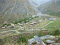
 Aerial view before the construction of the Matterhorn Terminal |
|
| Location of the municipality | |
  |
|
Tasch is a municipality and a civic community of the district Visp and a parish of the deanery Visp of the German-speaking part canton of Valais in Switzerland .
geography
The political municipality is located in the Mattertal and includes the village of Täsch and the hamlets of Zermettjen, Täschberg and the Täschalp hiking area.
Täsch is the last place in the Mattertal before Zermatt. From here the road has been closed to private traffic in the direction of Zermatt since 1972 and the Matterhorn-Gotthard Railway must be used. Passenger cars can be left in the large parking garage ( Matterhorn Terminal Täsch ) built in 2006 at the train station.
The Täschbach and Mattervispa flow through the municipality . The Täschbach is used for traditional irrigation at 1,500 m and has been laid completely in pipes for 1.2 km since 1992 as a bisse holding water .
The water meadows of the municipality are supplied with the bedload collector Chi via the Niwi and Halta-Hof water pipes . The irrigation is regulated by the municipal council or appropriate supervisors. The unauthorized discharge of water is a criminal offense.
In the so-called Täschgufer (Gufer = Valais German for rock debris, rubble), the erosion in three Murrinnen caused repeated damage to the valley floor and buried the cantonal road Stalden-Täsch , among other things . Rockfall blocks penetrated into populated areas. To prevent future debris flows , seven rockfall protection dams and two small retention basins were built on the slope. On the Europaweg, a gallery in the Täschgufer protects against falling rocks.
history

Täsch was first mentioned in 1302 as Tech (Latin Pera ). In the 13th century the nobles of Täsch had their seat here, whose last heir, Junker Johann, passed his rights on to the Am Hengart family before 1400. As early as 1305, Täsch and Randa formed a Kastlanei des Zenden Brig . The Meier or Grosskastlan von Brig was responsible as the highest judge until 1552 , after which the Kastlanei belonged to the Majorat St. Niklaus (Freigericht). The use of the Täschalp was mentioned in 1555, the delimitation of the area against Zermatt in 1560.
In 1798 Täsch and Randa separated. The northern borders with the Randaërn were not settled until 1841 after long disputes. Ecclesiastically, Täsch belonged to Visp or to the St. Niklaus parish until 1423 , when it became its own parish. The church from the 15th century had to give way to the new parish church in 1939.
Täsch has a municipal and a civic community, which meet together on the occasion of the original and citizens' assembly. The population increased steadily from 1798 with 140, 1850 with 177, 1900 with 251, 1950 with 413, to 2000 with 831 inhabitants.
population
| Population development | |||||||||
|---|---|---|---|---|---|---|---|---|---|
| year | 1798 | 1850 | 1900 | 1950 | 2000 | 2010 | 2012 | 2014 | 2016 |
| Residents | 140 | 177 | 251 | 413 | 831 | 1126 | 1165 | 1235 | 1237 |
economy
The development of the mountain farming village into a tourist destination in the 19th century was influenced by Zermatt. In 1891 Täsch was connected to the Brig-Visp-Zermatt Railway . The community assembly (original assembly) approved the construction of the Hotel Täschhorn, which opened in 1904, followed by six other hotels as well as numerous holiday apartments and chalets. Today the Social Medicine Center (SMZ) Zermatt is housed in the former Hotel Täschhorn.
In 2005, 88% of jobs were in the service sector, which in 2009 had over 90,000 overnight stays. Guest workers employed in Zermatt live in Täsch because of the lower rents.
tourism
The Europaweg from Grächen to Zermatt , opened in 1997, leads over the Täschalp , where the Europaweghütte Täschalp restaurant offers food and accommodation. Täsch is also the starting point for the Täschhütte and the Längfluegletscher .
The Matterhorn Golf Club's 9-hole course is located in the municipality of Täsch.
Views
Täschalp from the Europaweg

Water meadows in Täsch

Täsch in winter

Church / Täsch

Cemetery in Täsch

Country house in Täsch


literature
- Bernard Truffer: Täsch. In: Historical Lexicon of Switzerland . 2012 .
- Joseph Zurbriggen: Täsch. Family Statistics, Chronicle and Church . Brig 1952 (reprinted 1990)
- Leo Lauber: Täscher Chronicle 1952-2007 . Valmedia publishing house, Visp 2009
Web links
- Täsch on the ETHorama platform
- Website of the municipality of Täsch
- Official WebGIS of the municipality of Täsch
- Pictures from Täsch
- Changes in the Murrinnen in Täschgufer since 1936 (PDF; 422 kB)
- Video impressions of an autumn hike above Täsch
Individual evidence
- ↑ Permanent and non-permanent resident population by year, canton, district, municipality, population type and gender (permanent resident population). In: bfs. admin.ch . Federal Statistical Office (FSO), August 31, 2019, accessed on December 22, 2019 .
- ^ Bernard Truffer: Sankt Niklaus (VS). In: Historical Lexicon of Switzerland .
- ^ Bernard Truffer: Täsch. In: Historical Lexicon of Switzerland .
- ↑ Längfluegletscher on ethorama.library.ethz.ch/de/node
Baltschieder | Eisten | Embd | Grächen | Lalden | Randa | Saas-Almagell | Saas-Balen | Saas-Fee | Saas-Grund | St. Niklaus | Stalden | Staldenried | Täsch | Törbel | Visp | Visperterminen | Zeneggen | Zermatt
Former communities: Eyholz | Gasenried | St. Niklaus Dorf | St. Niklaus Matt
Canton of Valais | Districts of the canton of Valais | Municipalities of the canton of Valais