Gasenried
| Gasenried / Ried | ||
|---|---|---|
| State : |
|
|
| Canton : |
|
|
| District : | Visp | |
| Municipal municipality : | St. Niklaus | |
| Postal code : | 3924 | |
| Coordinates : | 629.88 thousand / 114333 | |
| Height : | 1659 m above sea level M. | |
| Website: | www.st-niklaus.ch | |
|
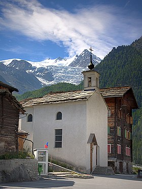
Chapel Ried St. Theodul ( 1661.6 m above sea level ) with Ried glacier (in the background), from the right Dürrenhorn ( 4035 m ), Hohberghorn ( 4219 m ), Stecknadelhorn ( 4241 m ) and Nadelhorn ( 4327 m ) of the Mischabel |
||
| map | ||
|
|
||
Gasenried ( Valais German Gasuriäd ), sometimes short Ried (Valais German Riäd ), is a large clustered settlement in the municipality of St. Niklaus (Valais German Zaniglas ) in the Valais district of Visp that is inhabited all year round .
geography
Gasenried lies at 1659 m above sea level. M. on the right flank of the valley above St. Niklaus Dorf ( 1120 m above sea level ). The old village center is grouped around the village chapel . The highest permanent settlement in the municipality of St. Niklaus is located on the Rieder Terrasse.

At the upper edge in the east, Gasenried is bounded by the Riedwald. To the north it borders on Grächen . The Ried Glacier lies in the southeast . To banish the glacier, the small chapel Schalbett was built at its foot . In the southwest below the settlement there is a steep pasture slope on which several farm buildings are scattered.
Today's picture is dominated by chalet , hotel and restaurant buildings up to the hamlet of Rittinen ( 1,455 m above sea level ) . Gasenried, together with Rittinen, is the sun terrace of the St. Niklaus community.
The panoramic view from the Ried Glacier of the Mischabel in the southeast and from the Weisshorn of the Weisshorn Group in the southwest to the Bietschhorn and the Aletsch Glacier in the north is magnificent.
Surname
The name Gasenried is historically documented, for example
- 1388 as am Riede in Chouson (= in St. Niklaus) and
- Cited as gases in 1574 .
In the Swiss name landscape, Ried, Riet (from Old High German hriot ) usually means 'moor, wetland'; as the basis of Swiss clearing names (to an unoccupied Old High German * riot ) the word is controversial. The former Franco-Provençal name of the place St. Niklaus «Chouson» lives on in the defining word Gasen , which possibly goes back to a Latin personal name, perhaps Calidius .
history
The territory of Gasenried has a total of three chapels, namely Ried, Schalbett and Rittinen , but has always belonged to the Roman Catholic parish of St. Niklaus .
In the Middle Ages the barons of Raron and Niedergesteln had feudal property in Gasenried.
From 1603 at the latest, when Gasenried signed a contract with Grächen for the use of water in the Riedbach , Gasenried was a separate municipality. In 1870, the previously politically independent municipality merged with the municipality of St. Niklaus .
- 1802 there are 107 inhabitants in Gasenried,
- 1850 86 inhabitants,
- 1860 174 inhabitants and
- 2015 150 inhabitants.
For the population originally oriented towards self-sufficiency in agriculture, the Autostrasse opened in 1952 brought major changes. On the one hand, a lot of construction activity began, because numerous chalets were built in the lower hamlets. On the other hand, it was now easier to take on work outside the village, with the Ried mainly orienting themselves in the direction of St. Niklaus Dorf, where the Scintilla works have been located since 1946 and which are now part of Robert Bosch GmbH .
population
| Population development | ||||
|---|---|---|---|---|
| year | 1802 | 1850 | 1860 | 2015 |
| Residents | 107 | 86 | 174 | 150 |
Attractions
Hiking trails and alpine tours
- Hikes along the "Wasserleite" of the Riedbach ,
- Hike to the Maiensäss Flüe ,
- Europaweg from Gasenried ( 1659 m ) to Zermatt ( 1608 m ),
- Balfrin high-altitude trail from Gasenried via Grächen ( 1619 m ) to Saas-Fee ( 1798 m ), the alternative route from Gasenried over the Seetal Pass ( 2975 m ) directly to Saas Fee can also be taken.
- The Bordierhütte ( 2,886 m above sea level ) of the SAC is also accessible from Gasenried , the central starting point for high-altitude tours to the summit
- of the Nadelgrat with Nadelhorn ( 4327 m ), Stecknadelhorn ( 4241 m ), Hohberghorn ( 4219 m ) and Dürrenhorn ( 4035 m ) as well
- the Balfring group with Ulrichshorn ( 3925 m ), Balfrin ( 3796 m ), Gross Bigerhorn ( 3626 m ), Klein Bigerhorn ( 3182 m ), Färichhorn ( 3292 m ), Platthorn ( 3246 m ) and Gabelhorn ( 3136 m ).
literature
- Philipp Kalbermatter: Gasenried. In: Historical Lexicon of Switzerland . 2005 .
Web links
Individual evidence
- ↑ Ried as a clearing name is particularly attested for Bavarian, cf. Adolf Bach: Deutsche Namenkunde, Volume II.1, S. 314 as well as Johann Andreas Schmeller: Bavarian Dictionary II 60. The meaning is according to Schweizerischer Idiotikon VI 1731 (Bed. Ried 2 ) for the older time, however only weakly attested and completely the canton of Bern restricted to also occupy the southwest Alemannic; Based on this, Peter Glatthard, place names between Aare and Saane, Paul Haupt, Bern / Stuttgart 1977, 339–384, interprets numerous reed names in the western canton of Bern as clearing names. Regarding the occurrence as a clearing name, however, the Nidwalden Orts- und Flurnamenbuch III 1667, the Schwyz name book IV 86, the Thurgau name book II.2 452, the Urner name book II 1078 and the Zug name book IV 51 are completely unmentioned in the Appenzeller name book II.3 1481, in the Lucerne name book I.2 786 and in the Rhaetian name book II 470. The Thurgau name book II.2 452 writes on the subject: «Occasionally in the literature it is indicated that Riet could also be a subsidiary form of Rüti ( nhd. Reute ) or another derivation from the same verbal basis and thus designate Rodeland. This is especially true for Bavaria, but hardly for our region. " The main problem with the Alemannic occurrence of Ried as a clearing name lies in the very marginal appearance as an appellative, which requires interpretation .
- ↑ Lexicon of Swiss Community Names , ed. from the Center de Dialectologie at the University of Neuchâtel under the direction of Andres Kristol, Frauenfeld / Lausanne 2005, p. 793 f. (under Sankt Niklaus VS ).


