Ulrichshorn
| Ulrichshorn | ||
|---|---|---|
|
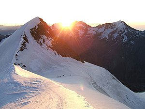
Ulrichshorn from the southwest at sunrise, from the northeast ridge of the Nadelhorn |
||
| height | 3925 m above sea level M. | |
| location | Canton of Valais , Switzerland | |
| Mountains | Valais Alps | |
| Dominance | 0.52 km → Nadelhorn | |
| Notch height | 80 m ↓ Windjoch | |
| Coordinates | 633 862 / 107459 | |
|
|
||
| First ascent | August 10, 1848 under the direction of Melchior Ulrich | |
| Normal way | From the Mischabelhütte via Windjoch and southwest ridge (glacier tour) | |
The Ulrichshorn ( 3925 m above sea level ) is a summit in the Mischabel group of the Valais Alps west of the Saas Valley . The mountain is located a little southwest of the Windjoch, the south-west ridge rising up from the Windjoch ( 3850 m above sea level ) forms the continuation of the north-east ridge of the Nadelhorn ( 4327 m above sea level ). The summit is known for its view, the view of the northeast face of the Lenzspitze ( 4294 m above sea level ) and the Nadelgrat is particularly noteworthy .
The mountain was named after Melchior Ulrich , a Swiss alpinist and theologian from Zurich, under whose direction the first ascent was possible in 1848.
Routes
The easiest ascent leads from the Mischabelhütte ( 3335 m above sea level ) first west on the ridge that pulls down from the Lenzspitze until you enter the Hohbalm glacier at almost 3,600 meters . The Windjoch is reached via this in a north-westerly direction. In the last steep ascent to the Windjoch, you first head directly towards the Ulrichshorn and only finally turn west to the yoke to avoid the crevasse zone . The short, very narrow southwest ridge from the high wind to the summit is seldom covered with snow , but occasionally icy. From the Mischabelhütte two hours of ascent time are to be estimated. Up to the Windjoch this ascent corresponds to the normal route on the Nadelhorn , so that the Ulrichshorn is often taken along when climbing the Nadelhorn.
Another possibility of ascent is via the north ridge from the Riedpass ( 3561 m above sea level ). The ridge is in the lower area a broad back of fir, which has a few cracks. Only at the top does the line get narrower. From the Bordierhütte ( 2886 m above sea level ) this ascent variant takes 3½ hours.
Literature and maps
- Michael Waeber: Area Guide Valais Alps . 13th edition, Bergverlag Rother, Munich 2003, ISBN 3-7633-2416-X
- National map of Switzerland 1: 50,000, sheet 5006, Matterhorn - Mischabel
- National map of Switzerland 1: 25,000, sheet 1328, margin
- Hiking map, ski tours 1: 25,000, Saas Fee . 2007, Rotten Verlag, ISBN 978-3-905756-25-8 (map base: national maps of Switzerland 1: 25,000)

