
Saas Valley
| Saas Valley | ||
|---|---|---|
 Saastal with Saas-Fee (left) and Saas-Grund (center). In the background the snow-capped Bernese Alps . |
||
| location | Canton of Valais | |
| Waters | Saaservispa | |
| Mountains | Valais Alps , Mischabel and Weissmies group | |
| Geographical location | 638 243 / 107359 | |
| Topo map | National map of Switzerland 1: 25,000 (LK25), sheet 1329, Saas | |
|
||
| Type | Vorderes Saas Valley: V valley ; rear Saas valley : U valley | |
| height | 723.5 to 4545 m above sea level M. | |
| use | Winter and summer tourism, agriculture and alpine farming , hydropower | |
| particularities | Largest concentration of four thousand meter peaks in the Alps | |

The Saas Valley ( French Vallée de Saas ) is the valley of the Saaservispa . It is a side valley in the Upper Valais in Switzerland .
geography

_(14576904889).jpg)
The Saas Valley is primarily known for the ski resorts of Saas-Fee and Saas-Grund, the proximity to the Mattertal with Zermatt and the access to the alpine attractive areas of the Mischabel chain with the highest peak in Switzerland, the cathedral .
The Saas Valley is the eastern branch of the Vispertal , in which it unites with the Matter Valley to the west near Stalden . Coming from the Rhone Valley , you get to Eisten and Saas-Balen via Visp and Stalden , then to Saas-Grund . From Saas-Grund, following the valley further south, you reach Saas-Almagell and later the Mattmark dam or, branching off to the right, Saas-Fee, a good 200 meters higher .
To the south and south-east, the Saas Valley borders on the Italian Valle Anzasca with the capital Macugnaga . The Monte Moro , Ofental and Antrona passes in the Saas Valley used to serve as smugglers' routes. After the opening of the Simplon Pass , the difficult to access and high passes in the Saas Valley lost their importance.
history
In 1851, Canon Peter Joseph Ruppen wrote The Chronicle of the Saas Valley, which is still considered the standard work on the Saas Valley today. It was based on the records of Dean Peter Joseph Zurbriggen (Saas family statistics no. 553). Notary Alois Zurbriggen and Pastor Imseng added scholarly supplements to this chronicle. The manuscript has been preserved to this day.
Until 1893, the communities Almagell, Balen, Fee and Grund formed a single parish of the Visp deanery . The talk church was in Saas-Grund. The residents of the three communities Almagell, Balen and Fee had to go to Saas-Grund for all church affairs such as baptism, confirmation, marriage, burial, etc.
The endangered Saaser Mutte sheep originated in the Saas Valley.
Largest concentration of four thousand meter peaks in the Alps
The Saas and Mattertal valleys rise up to the Matterhorn and Monte Rosa (the mightiest and second highest mountain range in the Alps), which is south of the Mischabel range that they encompass , and 38 four-thousand-meter peaks , which is the greatest concentration of the four-thousand-meter peaks in the Alps . On the right side of the Saas Valley are the two four-thousand-meter peaks of the Weissmies group with Weissmies and Lagginhorn , 36 four-thousand-meter peaks surround the Mattertal.
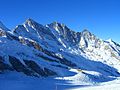
Täschhorn , Dom and Lenzspitze (from left)
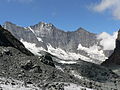
Cathedral ( 4545 m above sea level )

The Allalinhorn , a four-thousand-meter peak that is easy to climb

Landscape in the rear Saas Valley with Stellihorn

.jpg)


Municipalities

The Saas Valley forms a total of eight communities, with the five communities Eisten, Saas-Balen, Saas-Grund, Saas-Fee and Saas-Almagell being 100% in the Saas Valley. The eight municipalities of the valley (from top to bottom - so south to north) are
- Saas-Almagell ,
- Saas-Fee ,
- Saas-Grund ,
- Saas-Balen ,
- Ice ,
- Staldenried ,
- Visperterminen
- and at the Association of the Vispertäler:
- Stalden .
Saas-Grund is the former capital of the Saas Valley and the second largest village in the Saas Valley after Saas-Fee . The villages of Saas-Almagell ( 1672 m ), Saas-Grund ( 1559 m ), Saas-Balen ( 1483 m ) and Eisten ( 1086 m ) are on the valley floor on the Saaservispa, the villages of Saas-Fee ( 1798 m ) and Staldenried ( 1052 m ) on the slope of the Saas Valley.
Saas-Almagell
Saas-Almagell is the southernmost of the municipalities in the Saas Valley and has 370 inhabitants (as of December 31, 2018). Immediately following Saas-Almagell is the Mattmark dam , the highest earth dam in Europe (2197 m). For winter sports enthusiasts there is a ski area and cross-country skiing trails, for hikers there is a large network of hiking trails available all year round.
Saas-Fee
Saas-Fee is the largest town in the Saas Valley with 1,564 inhabitants (as of December 31, 2018). The municipality has the largest ski area in the municipality. Saas-Fee is car-free.
Saas-Grund

Saas-Grund has 1000 inhabitants (as of December 31, 2018) and is the central part of the Saas Valley. In Saas-Grund, the road splits to Saas-Fee and Saas-Almagell. The place has a sunny skiing and hiking area (Hohsaas, Kreuzboden) and - like the rest of the Saas Valley - is geared towards tourism.
Saas-Balen
Saas-Balen has 347 inhabitants (as of December 31, 2018) and is best known for its round church and the Fellbach. There is only one ski lift in the village, which is why winter tourists often switch to the neighboring villages.
Web links
- Cultural objects in the Saas Valley
- Paul Martone: Saas Valley. In: Historical Lexicon of Switzerland .
- Saastal on the ETHorama platform
Individual evidence
- ↑ Entry on Saaser Mutten on the pro specie rara website
- ↑ «Saaser Mutte», acutely threatened with extinction, on the SRF website
- ↑ Christian Imboden: Mountains: Profession, Vocation, Fate. Rotten Verlag, Visp 2013, p. 50.
- ↑ Christian Imboden: Mountains: Profession, Vocation, Fate. Rotten Verlag, Visp 2013, p. 12.
- ^ Paul Martone: Saas-Grund. In: Historical Lexicon of Switzerland .