Antronapass
| Antronapass | |||
|---|---|---|---|
|
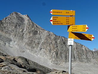
Signpost on the pass |
|||
| Pass height | 2838 m above sea level M. | ||
| region | Canton of Valais , Switzerland | Verbano-Cusio-Ossola Province ( Piedmont Region , Italy) | |
| Watershed | Saaser Vispa → Vispa → Rhone | Ovesca → Toce → Lake Maggiore → Ticino → Po | |
| Valley locations | Saas-Almagell ( Saas Valley ) | Antrona Schieranco ( Valle Antrona ) | |
| expansion | Mule track | ||
| Mountains | Valais Alps | ||
| map | |||
|
|
|||
| Coordinates , ( CH ) | 46 ° 2 '16 " N , 8 ° 1' 13" O ( 645 025 / 98625 ) | ||
The Antronapass , formerly also Saaserberg or Saaserfurka , Italian Passo di Saas , is 2838 m above sea level. M. high Saumpass over the Alps . The border between Italy and Switzerland runs at the top of the pass . The Antronapass connects the municipality of Saas-Almagell in the canton of Valais with Antrona Schieranco in the Valle Antrona in Italy.
The Antronapass was first mentioned in 1217. In 1415 the inhabitants of the two valleys agreed to open the pass and to maintain it. After 1791, the path to the mule track was expanded and partially paved. In 1792, a salt sausage was opened on the pass . After the opening of the Simplon Pass , the interregional movement of goods between the two valleys ended.
View from the pass to Lake Cingino
literature
- Arthur Fibicher: Antronapass. In: Historical Lexicon of Switzerland . April 8, 1998 .


