
Toce
| Toce (Eng. Tosa) | ||
 The course of the Toce |
||
| Data | ||
| location | Northern Italy | |
| River system | Po | |
| Drain over | Lake Maggiore → Ticino → Po → Mediterranean | |
| source | Near the Griesspass | |
| Source height | 1720 m | |
| muzzle | in Lake Maggiore near Fondotoce Coordinates: 45 ° 56 ′ 11 " N , 8 ° 29 ′ 36" E 45 ° 56 ′ 11 " N , 8 ° 29 ′ 36" E |
|
| Mouth height | 193 m | |
| Height difference | 1527 m | |
| Bottom slope | 20 ‰ | |
| length | 76 km | |
| Right tributaries | Strona | |
The Toce (German: the Tosa; Walser German d Riis ) is a 76 km long river in the northern Italian region of Piedmont and hydrologically the largest water feeder of Lake Maggiore , although the Ticino brings only slightly less water into it.
It rises on the south side of the Gries Pass, which belongs to Italy (near the Nufenen Pass ), not far from the Swiss border.
Below Frütt (Italian: La Frua) it falls over a first valley step as a waterfall, the Cascata del Toce , 143 m down into Val Formazza (Eng. Pomatt). It flows through the Val Formazza and, after another valley step, the Valle Antigorio . In the glacier park of Uriezzo near Baceno , he formed a complex of gorges when the Toce Glacier melted after the Ice Age. At Crevoladossola , the Diveria coming from the Simplon Pass flows from the right . Here the valley widens, which from here on is called Valle d'Ossola . The Toce passes the main town of the valley, Domodossola , furthermore Villadossola and Ornavasso . In spite of the intensive development of the valley, it retains its character as a wild river lying broadly. After 76 km it flows into Lake Maggiore at Fondotoce - halfway between Gravellona Toce and Verbania- Pallanza .
Important tributaries
- Diveria (near Crevola d'Ossola)
- Melezzo Occidentale (near Domodossola)
- Ovesca (near Villadossola)
- Anza (near Piedimulera )
- Strona (near Gravellona Toce)
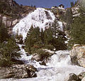
The Tosafall at Frütt

in the Uriezzo Gorges
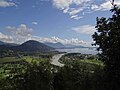
Toce - confluence with Lake Maggiore


Web links
- Toce on the ETHorama platform