Simplon Pass
| Simplon Pass Passo del Sempione |
|||
|---|---|---|---|
|
Simplon Pass with Monte Leone, Breithorn and Hübschhorn |
|||
| Compass direction | North | south | |
| Pass height | 1995 m above sea level M. | ||
| Canton |
|
||
| Watershed | Taferna, Saltina , Rotten | Chrummbach, Diveria (Doveria), Toce ( Po ) | |
| Valley locations | Brig ( Switzerland ) | Domodossola ( Italy ) | |
| expansion | Pass road | ||
| Built | 1800-1805 | ||
| Lock | Open all year round | ||
| Mountains |
Valais Alps (west) Leone group (east) |
||
| profile | |||
| Denzel scale | SG 1-2 | SG 1-2 | |
| Ø pitch | 6.4% (1321 m / 20.5 km) | 4.2% (1732 m / 41 km) | |
| Max. Incline | 9% | 9% | |
| map | |||
|
|
|||
| Coordinates | 645 225 / 122198 | ||
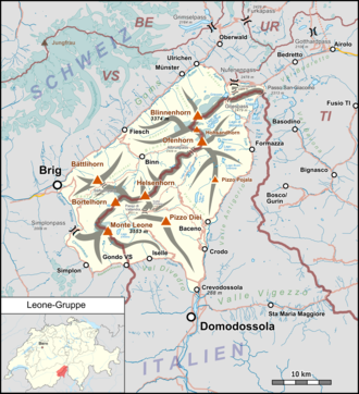
The Simplon Pass ( Italian Passo del Sempione ) is a 1995 m above sea level. M. high mountain pass in the Swiss canton of Valais and separates the Valais Alps in the west from the Leone group in the east.
geography
The Simplon Pass connects the Rhone Valley in the Swiss canton of Valais with the Val d'Ossola in the Italian province of Verbano-Cusio-Ossola and Lake Maggiore . The glaciated Fletschhorn towers above it on the south side ; The Spitzhorli ( 2736 m above sea level ) is located a little to the northwest . There are two natural lakes at the pass, the Rotelsee and the Hopschusee ; two more have been artificially created.
Traffic routes
Since there is a wetland around the deepest point of the watershed, the traffic routes pass east above, which is why the apex of the pass road is 2006 m above sea level. M. achieved. It begins on the north side in Brig and leads past the hospice . On the other side follows the village of Simplon , which is already looking southern, and the border community of Gondo . It is main road 9 , a third class national road . In Italy, the towns of Iselle , Varzo and Domodossola follow .
The Alpine Passes Trail also leads over here; its 14th stage runs a little further east and even reaches 2032 m above sea level. M. before it goes down to the hospice ( 1998 m above sea level ).
In the vicinity of the pass, the Simplon Tunnel (a railway base tunnel ) built between 1898 and 1921 runs under the Monte Leone massif .
history
Around the middle of the 17th century, the mule track over the pass was expanded by the owner of the salt monopoly, Kaspar Stockalper , today Via Stockalper . At the top of the pass he built the Spittel and in Gondo a warehouse, the so-called Stockalper Tower. During this time, the goods were carried over the pass with mules (the so-called "seaming" ). This traditional method of transporting goods was in use in Valais until the 20th century.
The pass gained its national importance only after Napoleon I had a paved pass road built from 1801-1805 to make the pass passable for his artillery . Since then, the Simplon has been accessible by stagecoach . In 1801, on Napoleon's orders, the construction of the Simplon Hospice began, which was completed in 1831 by the Augustinian Canons of the Hospice on the Great St. Bernhard .
In September 1910, Jorge Chávez Dartnell flew over the pass from Brig and was the first to cross the main Alpine ridge in a powered aircraft. He fell on landing in Domodossola from a height of 10-20 m and suffered fatal injuries.
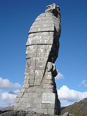
The pass was of great importance during the Second World War . Its southern flank has been greatly expanded militarily from the border with Italy to the top of the pass. One of the historical witnesses is Fort Gondo. The symbol of the Simplon Pass, the golden eagle , also dates from this time .
During the planning of the national road network in the middle of the 20th century, the pass road was included in the national road network as the A9 and in the 1970s and 1980s by the construction of numerous bridges, e.g. B. Ganterbrücke and galleries , expanded to be winter-proof. Long stretches of the historic Napoleon road were destroyed. Today the Simplon is considered the best-developed pass crossing in Switzerland and has developed into a transit route for heavy traffic, which is used by around 80,000 trucks annually (as of 2007). Although the Simplon road is a national road, the pass can also be used by bike.
The pass is a firing range for regular artillery exercises of the Swiss Army .
tourism
In the Simplon area hikes can be undertaken, e.g. B. the Stockalperweg from the Simplon hospice past the old hospice to the village of Simplon and on through the Gondoschlucht to Gondo , walking time approx. 4½ hours. The Simplon Pass is accessed from Brig to Domodossola with the Swiss Postbus . Travel time is 1 hour 40 minutes.
gallery
Simplon Hospice in the snow
Säumer on the Simplon Pass 2020
literature
- Hans-Niklaus Müller: Landscape history Simplon (Walliser Alps, Switzerland). Glacier, vegetation and climate development since the Ice Age . Institute for Geography and Geoecology, Karlsruhe 2005, ISBN 978-3-934987-10-4 .
- Michel François Delaloye (ed.): Simplon. Histoire, geology, mineralogy . Fondation Bernard et Suzanne Tissières, Martigny 2005, ISBN 2-9700343-2-8 .
- Thomas Köppel, Stefan Haas (eds.): Simplon. 100 years of the Simplon Tunnel . AS-Verlag, Zurich 2006, ISBN 3-909111-26-2 (trilingual G / I / F).
- Renato Arnold: Simplon Pass. In: Historical Lexicon of Switzerland . December 19, 2012 .
Web links
- Information about the pass at Simplon Tourism
- Hiking suggestions in the Simplon area
- www.a9-simplon.ch Official website of the Federal Roads Office FEDRO
- "Voyage pittoresque de Genève à Milan par le Simplon" by Gabriel Lory, an illustrated travelogue from 1811 (PDF; 13.6 MB)
- Simplonpass on the ETHorama platform
Individual evidence
- ↑ a b Location & heights according to Swisstopo (maps of Switzerland)
- ↑ Spitzhorli on ETHorama
- ^ Corina Kolbe: Aviation pioneer Jorge Chávez: Nightmare over the Alpine ridge spiegel.de/einestages, September 22, 2010, accessed September 24, 2018.
- ↑ Fort Gondo
- ↑ Simplon-Bergalpe shooting range ( Memento from May 31, 2013 in the Internet Archive ) (PDF; 4 kB) Retrieved September 11, 2019
- ↑ The Stockalperweg. Retrieved May 25, 2018.
- ↑ Gondo Gorge. Retrieved May 25, 2018.


