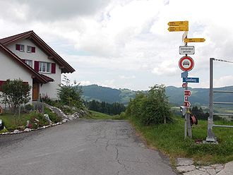
Chatzenstrick
| Chatzenstrick | |||
|---|---|---|---|
|
Chatzenstrick pass, coming from Einsiedeln |
|||
| Compass direction | west | east | |
| Pass height | 1053 m above sea level M. | ||
| Canton | Schwyz | ||
| Valley locations | Third Altmatt | Einsiedeln | |
| expansion | Unmade road | Pass road | |
| Lock | - | ||
| profile | |||
| Ø pitch | 6.8% (135 m / 2 km) | 5.6% (168 m / 3 km) | |
| Max. Incline | ? % | ? % | |
| map | |||
|
|
|||
| Coordinates | 697 352 / 221 396 | ||
The Chatzenstrick is in the Swiss canton of Schwyz situated passport and pilgrimage of the villages Einsiedeln and Altmatt together. The pass is at 1053 m above sea level. M. with a difference in altitude of around 150-200 meters.
Coming from Einsiedeln, the road is paved throughout up to the top of the pass. From there, the gravel road towards Altmatt is closed to motorized traffic.
The Maria End chapel is located next to the former Katzenstrick inn.
Catering
Coming from Einsiedeln, a few hundred meters before the top of the pass, is the «Katzenstrick» inn. From its sun terrace you have a good view of the Schwyz and Glarus Alps and Einsiedeln. The restaurant is closed (as of April 2018).
etymology
The Chatzenstrick / Katzenstrick has nothing to do with a cat (Swiss German: Chatz) or with a rope. The first part of the word goes back to a farmer named Kätzi (also written Chätzi) who worked this area. The second part of the word comes from dashes. This is a field name (Old High German Strih = strip, district, Middle High German dash = area). The original name was: Chätzi's strokes, which means something like: the land of Chätzi.
The pilgrimage of Lucerne to the pilgrimage site Einsiedeln used to lead via the cat rope, which has given it the nickname cat stretcher.


